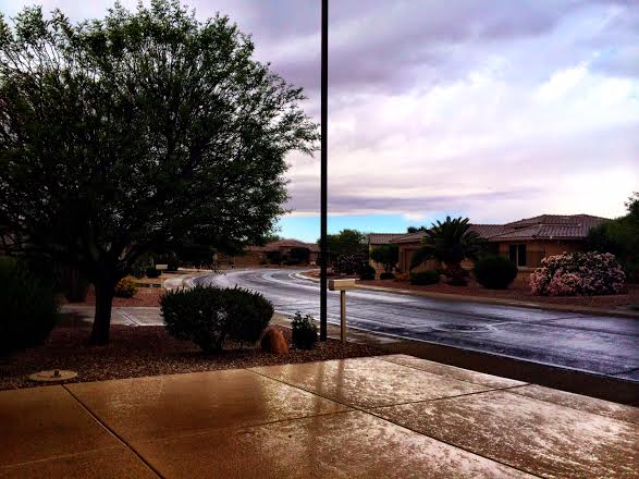
I'm spending some time with my family in Arizona and what might have been 'normal' to me, was anything but for the locals here in Phoenix. The last time there was measurable rain in Phoenix, AZ was in early March. Temperatures in the 60s also led to several complaints about how cold it was. While my mother (former Minnesotan) looked like she was dressed for a winter Olympic competition, I was in shorts and flip-flops.
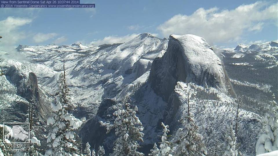
Sierra Snow
This was the view from Yosemite National Park in California early AM Saturday after nearly 2ft. of snow came down in parts Sierras since late last week.
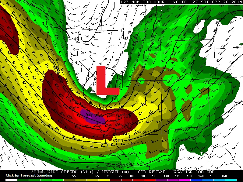
Intense Winds
WOW! The 500mb level showed a near 100kt+ wind over southern California on Saturday morning. This type of intense wind will help to make the storm system even stronger over the coming days!
Storm Pushes East
The same storm system that brought rain and snow to places in the west will continue to move slowly into the central part of the country. Heavy rain and severe weather appears to be the main threat going forward through the rest of the weekend/early next week.
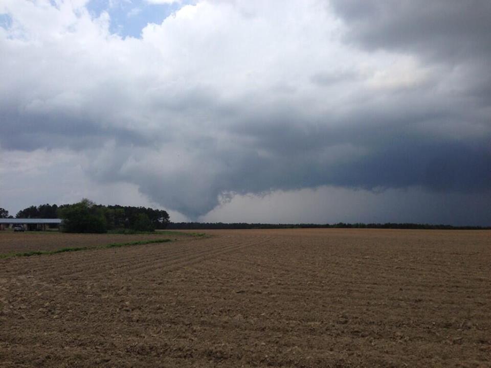
Severe Threats Continue
A multi-day severe weather threat continues through early next week as a powerful Pacific storm continues to wobble east. The image below was from Goldboro, NC as our last storm system departed the Eastern Seaboard.
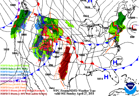
Friday's Storm Reports

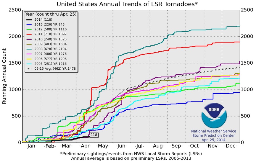
2014 Tornado Reports
Thanks to all of the tornado reports in North Carolina on Friday, the 2014 PRELIMINARY tornado reports through April 25th have climbed to 118. According to NOAA's SPC, the 118 PRELIMINARY tornado reports through April 25th is the lowest number of reports the 2005-2014 reports below. Last year saw 226 tornado reports, while in 2012, there were 588 reports.
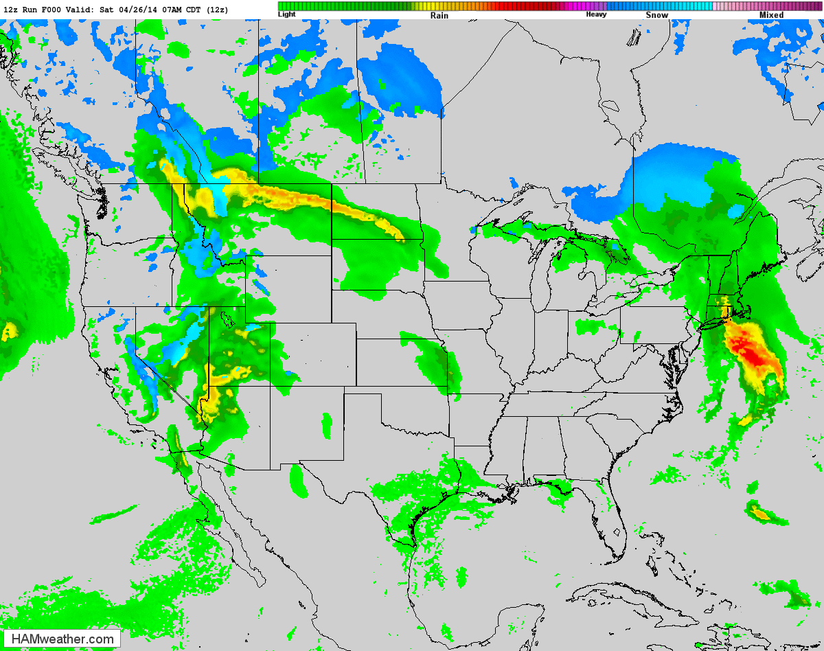
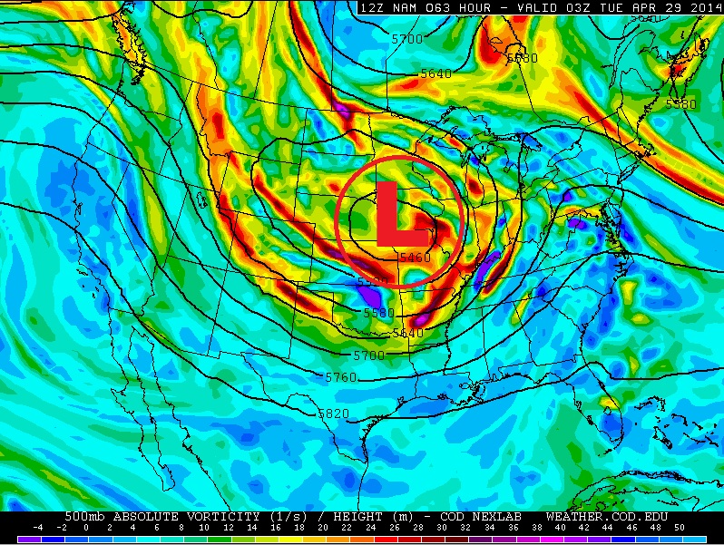
Strong Pacific Storm Moves Inland...
The loop below from AM Saturday to AM Tuesday shows our latest strong Pacific storm working into the central U.S. with several rounds of severe weather potential.
Severe Threat Sunday
Sunday's severe threat looks quite interesting across the mid-section of the nation. A MODERATE RISK of severe weather has been issued in parts of the middle and lower Mississippi Valley. Hail, high winds and even tornadoes can't be ruled out. Stay aware of the weather situation if you live in these areas Sunday!!
...NEB...IA...NERN KS...NWRN MO... SEVERE STORMS ARE EXPECTED TO FORM BY EARLY AFTERNOON AHEAD OF THE SURFACE LOW. COLD TEMPERATURES ALOFT AND FAVORABLY ORIENTED DEEP-LAYER SHEAR VECTORS ACROSS THE DRYLINE WILL SUPPORT NWD MOVING SUPERCELLS CAPABLE OF LARGE HAIL AND A FEW TORNADOES.
...ARKLATEX INTO SRN MO... STRONG INSTABILITY WILL DEVELOP AHEAD OF THE DRYLINE AS MID TO UPPER 60S DEWPOINTS SURGE NWD AND HEATING OCCURS. DEEP-LAYER SHEAR WILL BE PERFECTLY ORIENTED RELATIVE TO THE DRYLINE FOR DISCRETE SUPERCELLS. GIVEN THE DEGREE OF BOUNDARY LAYER CONFLUENCE AHEAD OF THE DRYLINE...AND STRONG HEATING AND MOISTENING...A PRE-FRONTAL BAND OF SUPERCELLS COULD FORM OVER SRN AR...NRN LA...AND NERN TX. SUPERCELLS WILL INITIALLY BE CAPABLE OF VERY LARGE HAIL...WITH AN INCREASING TORNADO THREAT AS THEY MATURE DURING THE LATE AFTERNOON AND EVENING. SEVERAL STRONG TORNADOES APPEAR POSSIBLE...AND A HIGH RISK COULD BE ISSUED IN SUBSEQUENT OUTLOOKS ONCE CONFIDENCE IN THE BEST CORRIDOR INCREASES.
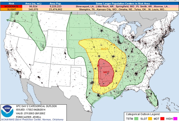
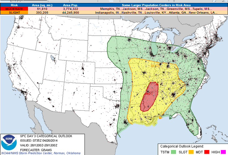
Monday Severe Threat
The Storm Prediction Center has issued another MODERATE RISK on Monday just east of Sunday's MODERATE RISK area. Monday could feature another day with tornadoes...
...MIDWEST TO CNTRL GULF COAST...
A PLUME OF 60S SURFACE DEW POINTS WILL BE ESTABLISHED FROM THE WARM FRONT IN THE MIDWEST S/SWWD TO THE WRN/CNTRL GULF COAST AND PERSIST AMIDST STRONG LOW-LEVEL S/SWLYS. ALTHOUGH CONVECTION WILL LIKELY BE ONGOING AT 12Z/MON FROM PARTS OF THE MIDWEST TO MID-SOUTH...ROBUST DIURNAL HEATING SHOULD OCCUR IN CONVECTIVE-FREE AREAS TO SUPPORT AT LEAST MODERATE BUOYANCY OVER MUCH OF THE WARM SECTOR BY AFTERNOON. LOW/DEEP-LAYER SHEAR WILL BE QUITE STRONG OWING TO THE AFOREMENTIONED SPEED MAX. THIS CO-LOCATION WITH THE ESTABLISHED WARM SECTOR YIELDS A LARGE AREA OF ORGANIZED SEVERE POTENTIAL. THE MOST CONCENTRATED CORRIDOR FOR HIGH-END SEVERE RISK APPEARS CENTERED OVER PARTS OF THE LOWER MS VALLEY TO MID-SOUTH. WIDESPREAD STORMS APPEAR PROBABLE DURING THE AFTERNOON...LIKELY EMANATING FROM REGENERATIVE CONVECTIVE CLUSTERS ALONG THE DRYLINE/CONVECTIVE OUTFLOWS. WITH EFFECTIVE SHEAR AOA 50 KT AND SURFACE DEW POINTS INTO THE MIDDLE TO UPPER 60S...SETUP COULD YIELD SEVERAL SUPERCELLS WITH STRONG TORNADOES AND LARGE HAIL...EVOLVING INTO BOWS AND WIDESPREAD DAMAGING WINDS.
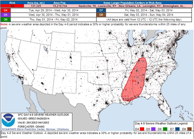
Severe Threat Tuesday
..DISCUSSION... THE MULTI-DAY SEVERE WEATHER EPISODE ASSOCIATED WITH THE PERSISTENT UPPER-LEVEL TROUGH OVER THE CNTRL CONUS SHOULD CONTINUE INTO D4/TUE AS THE LAST IN A SERIES OF INTENSE MID-LEVEL SPEED MAXIMA EJECTS THROUGH THE BASE OF THE TROUGH. THIS SHOULD RESULT IN STRONG KINEMATIC FIELDS OVERSPREADING A GULF WARM SECTOR CHARACTERIZED BY 60S SURFACE DEW POINTS. THE BREADTH OF THE WARM SECTOR WILL PROBABLY BE CONFINED BY WIDESPREAD ANTECEDENT CONVECTION ON D3. HOWEVER...GUIDANCE IS FAIRLY CONSISTENT WITH DIURNAL DESTABILIZATION OCCURRING AHEAD OF THE PACIFIC COLD FRONT/EFFECTIVE DRYLINE. THE CAPE/SHEAR COMBINATION APPEARS FAVORABLE FOR HIGHER-END SEVERE RISK FOCUSED FROM THE CNTRL OH VALLEY TO THE CNTRL GULF COAST. OVERALL KINEMATIC FIELDS SHOULD BE IN A WEAKENING STATE ON D5/WED AND BECOME INCREASINGLY DISPLACED FROM GREATER BUOYANCY AS THE FRONT ACCELERATES EWD. NEVERTHELESS...ORGANIZED SEVERE POTENTIAL IS EVIDENT FROM PARTS OF THE CNTRL APPALACHIANS AND MID-ATLANTIC SWD TO THE SOUTHEAST...LIKELY YIELDING EVENTUAL SLIGHT RISK DELINEATION.
Cut-Off Low Develops
The storm system becomes mature early this week. It intensifies so much that it becomes "Cut-off" from the upper level winds. This tends to keep weather systems stagnant. Weather conditions in the eastern two-thirds of the nation through much of the week ahead.
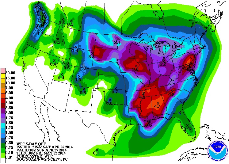
Wet Weather Ahead
According to NOAA's HPC, the 5 day precipitation forecast looks quite wet for a number of locations east of the Rockies. Some spots could wind up with 2" to 5" of rain by the end of next week!
Thanks again for checking in and have a great rest of your weekend and stay safe!