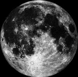
Moon Phase for April 13th at Midnight
1 Day Before Full (Pink) Moon
 .
.===================
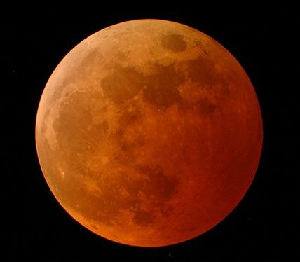
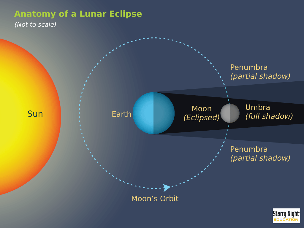
April 15th Full Moon and Lunar Eclipse
"April 15th at 3:42 a.m. EDT: Full Pink Moon —The grass pink or wild ground phlox is one of the earliest widespread flowers of the spring. Other names were the Full Sprouting Grass Moon, the Egg Moon, and —among coastal tribes —the Full Fish Moon, when the shad come upstream to spawn. In 2014 this is also the Paschal Full Moon; the first full moon of the spring season.
The first Sunday following the Paschal Moon is Easter Sunday, which indeed will be observed five days later on Sunday, April 20. This full moon will also undergo a total lunar eclipse and North America will have a ringside seat for it, as it will occur between midnight and dawn depending on your location. Totality will last almost 78 minutes."
Read more from Space.com.
WeatherNation Meteorologist Gretchen Mishek has more on the upcoming Lunar Eclipse in a recent blog:
"Mark the calendar for April 15 as the stars align for a total lunar eclipse. The peak time of the eclipse will be at 3:45 a.m. EDT. It will be the first time that this occurs on over 2 years and mark the beginning of a series of lunar eclipses. The last time a total lunar eclipse was visible in the United States was December 11, 2011."
See her full blog HERE:
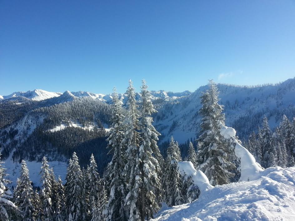
Ski Weather ContinuesThanks to my good friend Aaron Theis who recently got some late season skiing in at Steven Pass Ski Area. WOW! It looks amazing!!
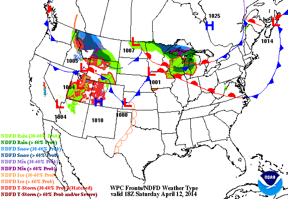
Weather Outlook
Here's the weather outlook through early next week, note the heavy snow that looks to continue along the Central Rockies/Front Range. Several inches of snow are expected in these areas through AM Monday. As the storm rolls out into the central part of the country, severe weather will continue to be an issue. Sunday afternoon/evening could be a little more interesting as the storm intensifies.
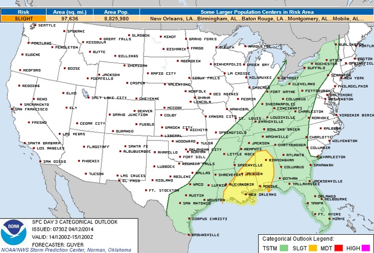
Severe Weather Potential
This multi-day severe weather event looks to continue into early next week, but the most significant severe weather threat will be Sunday.
Severe Threat Sunday
The Storm Prediction Center has issued a MODERATE risk of severe weather for parts of the Plains, but the SLIGHT risk extends from the Middle Mississippi Valley to the Gulf Coast of Texas and Louisiana. Hail and high winds will be the primary threat, but isolated tornadoes can't be ruled out.
OVERALL...FAVORABLE WIND PROFILES /45-50 KT EFFECTIVE SHEAR/ WILL SUPPORT INITIAL SUPERCELLS...ALTHOUGH INCREASINGLY UNIDIRECTIONAL WINDS AND THE INFLUENCE OF THE COLD FRONT SUGGEST THAT MULTICELLS/LINE SEGMENTS SHOULD EVOLVE BY EVENING IN MOST AREAS...WITH NEAR-COLD FRONTAL STORMS STEADILY BEING UNDERCUT BY THE COLD FRONT /FROM NORTHWEST TO SOUTHEAST/. LARGE HAIL IS EXPECTED TO THE DOMINANT HAZARD OVERALL...ALTHOUGH DAMAGING WINDS AND SOME TORNADOES WILL ALSO BE POSSIBLE SUNDAY AFTERNOON/EARLY EVENING IN AREAS NEAR/EAST OF THE SURFACE TRIPLE POINT INCLUDING EASTERN OK AND ADJACENT PARTS OF MO/AR/NORTH TX.

Monday Severe Threat
The severe weather threat continues into early next week as the storm system moves east. Heavy rain, hail and high winds still look to be the primary threat here, but an isolated tornado can't be ruled out here either.
THIS CONVECTION/ASSOCIATED CLOUD COVER PROVIDES SOME UNCERTAINTY...BUT THE FRONT-PRECEDING AIR MASS SHOULD CONTINUE TO MOISTEN/DESTABILIZE THROUGH THE AFTERNOON AHEAD OF THE FRONT AND AN ANTICIPATED SURFACE FRONTAL WAVE /LIKELY SOMEWHERE ACROSS MS-AL-TN/. ALTHOUGH LOW-LEVEL WINDS MAY GRADUALLY WEAKEN BY AFTERNOON/EVENING IN MOST AREAS /ESPECIALLY AWAY FROM THE SURFACE LOW/...STRENGTHENING WINDS ALOFT AND RESIDUALLY STRONG LOW-LEVEL SHEAR/SRH MAY SUPPORT SUSTAINED LINE SEGMENTS/EMBEDDED SUPERCELLS CAPABLE OF DAMAGING WINDS...SOME HAIL...AND POSSIBLY A COUPLE OF TORNADOES INTO THE EVENING HOURS.
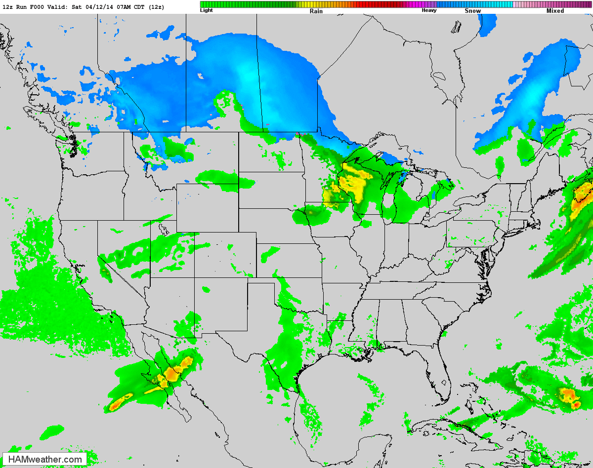
Future Radar
The higher resolution future radar shows the storm system wrapping up over the middle part of the country through early next week. This is a pretty classic spring storm with wintry precipitation on its western/northern flank and heavy rain/severe storms on it southeastern flank.
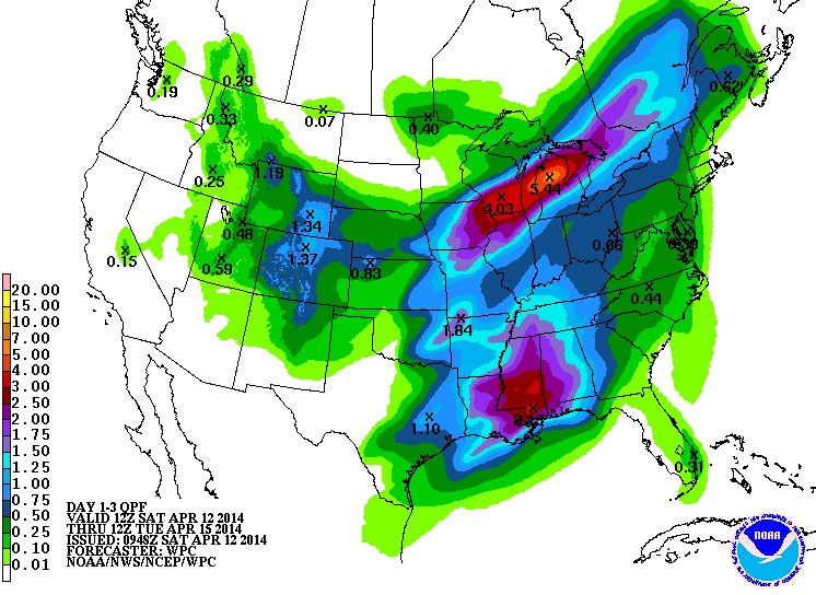
Precipitation Outlook
Take a look at the how much precipitation some spots could see through early next week. Keep in mind that these numbers reflect nearly the entire weekend from AM Saturday through AM Tuesday.
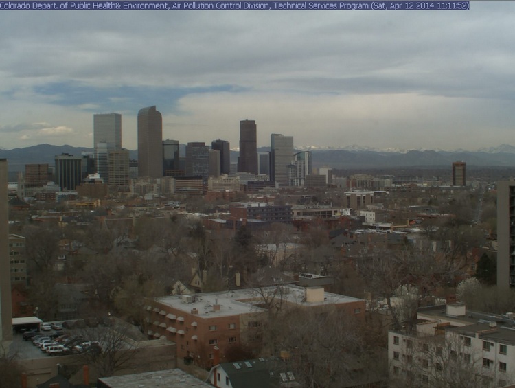
Snowy Front Range
This was the view from Denver, CO late Saturday morning prior to snow moving in. Snow is expected to accumulate through Sunday and as much as 4" to 8" can't be ruled out in spots, especially in the higher elevations.
TIMING...RAIN AND SNOW WILL DEVELOP LATE SATURDAY NIGHT ACROSS THE FRONT RANGE I-25 URBAN CORRIDOR. PRECIPITATION WILL BECOME ALL SNOW BY EARLY SUNDAY MORNING AND MAY BE HEAVY AT TIMES SUNDAY. THE SNOW IS EXPECTED TO DECREASE AROUND MIDNIGHT SUNDAY NIGHT. * SNOW ACCUMULATIONS...4 TO 8 INCHES POSSIBLE. TOTAL SNOW ACCUMULATIONS WILL DEPEND ON SNOW INTENSITY AND AMOUNT OF MELTING. * WIND/VISIBILITY...NORTHEAST 10 TO 20 MPH. VISIBILITIES MAY DROP TO A QUARTER MILE OR LESS DURING PERIODS OF HEAVY SNOW. * IMPACTS...HEAVY WET SNOW MAY ACCUMULATE SUFFICIENTLY ON ANY TREES THAT ARE BEGINNING TO LEAF OUT TO BREAK TREE LIMBS. SCATTERED BRIEF POWER OUTAGES WOULD BE POSSIBLE. SOME SNOW AND SLUSH MAY ACCUMULATE ON ROADS...ESPECIALLY BRIDGES AND OVERPASSES...DURING PERIODS OF HEAVY SNOWFALL.
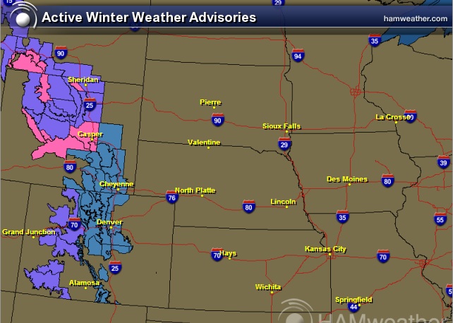
Winter Weather Headlines
Here are the winter weather headlines that have been posted along the Rockies/Front Range. Slushy spring accumulations here will be enough to shovel and plow in spots through PM Sunday/AM Monday.
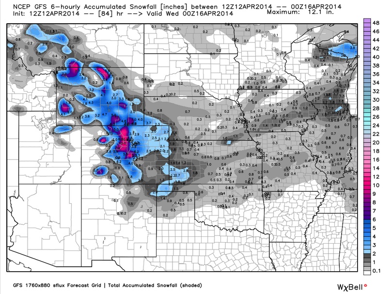
Snow Potential
The snow potential late Sunday/early Monday suggests up to 6" or more in spots along the higher elevations of the Rockies, while lower tallies will be found in the lower elevations. Also note how some lighter tallies of snow may be possible across the Plains/Midwest through early next week.
Memories of March
As this system begins to shift east, temperatures will return to more March-like temperatures. Here's the temperature outlook through early next week. Note how the cool air begins to invade the eastern part of the country.
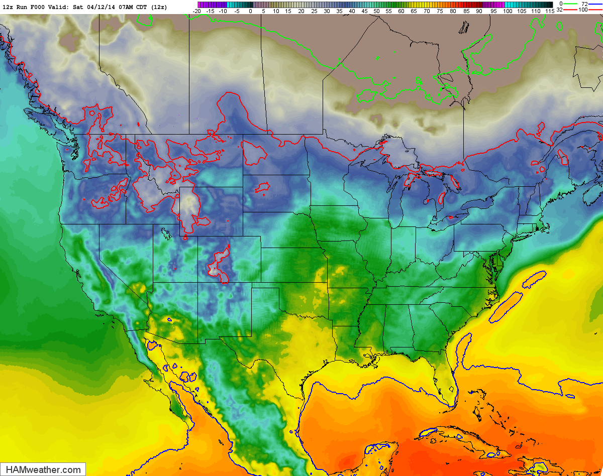
Monday Temperature Outlook
The temperature outlook for Monday looks quite chilly across the middle part of the country post front. However, temperatures ahead of the front look very spring-like across the eastern third of the country ahead of the front.

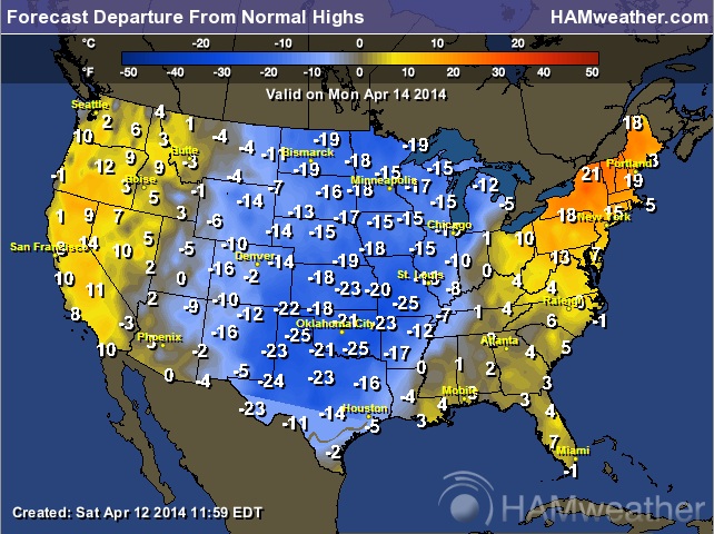
Monday Highs From Normal
This is a pretty significant chunk of cold air for mid April. Temperatures on Monday could be a good 10F to nearly 25F below average across the middle part of the country!
Thanks for checking in and have a great rest of your weekend! Don't forget to follow me on Twitter @TNelsonWNTV