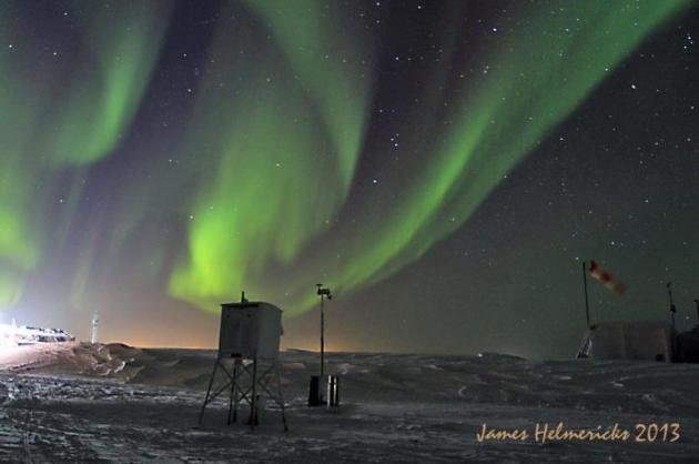
Great picture from James Helmericks out of Alaska (Shared by the National Weather Service Alaska Facebook page)!
"While out seeing how many stars I could see in Orion for the Globe at Night project the Aurora came out to dance. Took a photo of the Colville Village cotton shelter and drifts under the aurora."
International Falls Record Cold?
Question:
A major Dutch paper reported on the recent cold weather streak and mentioned that International Falls had a chance to break the low temperature record.
As ex-Minnesota residents (1968-1980) we are interested whether this happened indeed.
Regards
Hanneke and Bert Potjer
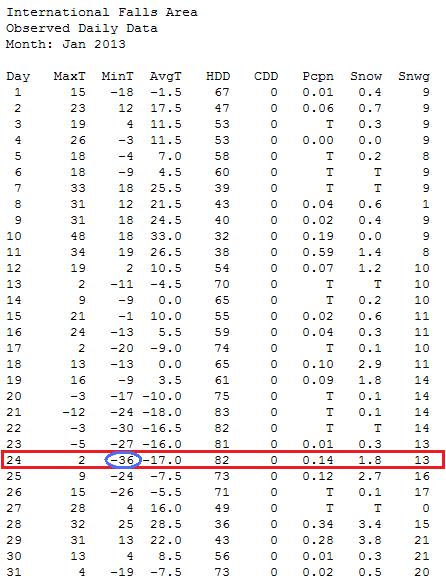
Thanks for your question Hanneke and Bert. I looked at the low temperatures recorded in International Falls, MN thru January and could find no record low temps. They got close, but no record lows were tied or broken.
The coldest February low temp was -39F on the 2nd. The record low for that day is -45 set in 1996.
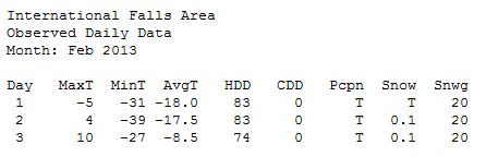
January's coldest overnight low in International Falls was -36, but not a record. The record for that date was -40 set in 1966.
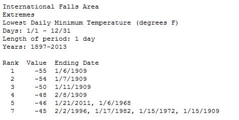
All-Time Cold in International Falls?
Here are some of the all-time coldest ever recorded in International Falls since 1897.
Coldest Temp in Minnesota?
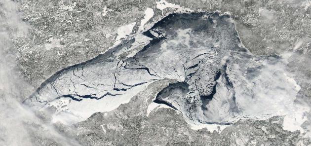
The coldest temperature in Minnesota ever recorded was -60F set February 6th, 1996. It was a cold winter in 1996, in fact, according to the Great Lakes Aquarium, Lakes Superior was nearly 100% frozen over.
The image below was taken early March 2009 when Lake Superior was nearly 100% frozen over... pretty cool! I actually remember this quite well because one of the Duluth High School Hockey teams had a practice on Lake Superior!
Clipper-Fest Continues
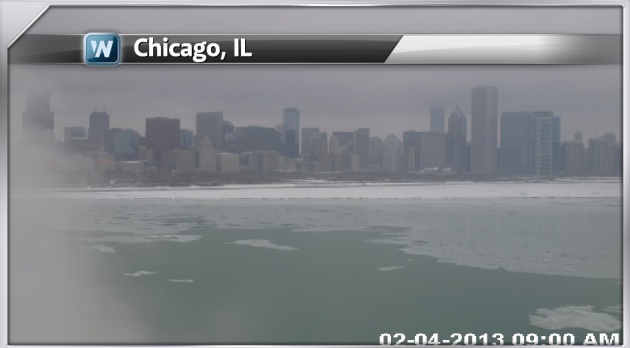
Take a look at the webcam from earlier Monday out of Chicago! Fast moving clipper systems have been sailing through the Upper Midwest/Great Lakes Region since late last week. Each system has dropped a couple/few inches of fluffy snow in a narrow band, which has already added up to shovelable/plowable amounts since the start of the month. Snow AM Monday led to substantial flight delays in Chicago, which may be possible again Tuesday as another clipper rolls in.
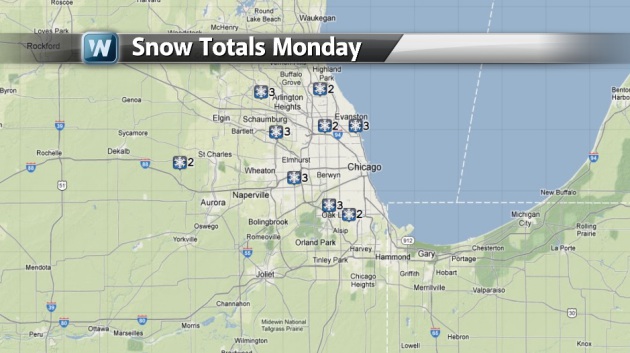
Monday Snow Totals
Here are some of the snow totals that were tallied across Chicago from PM Sunday-AM Monday.
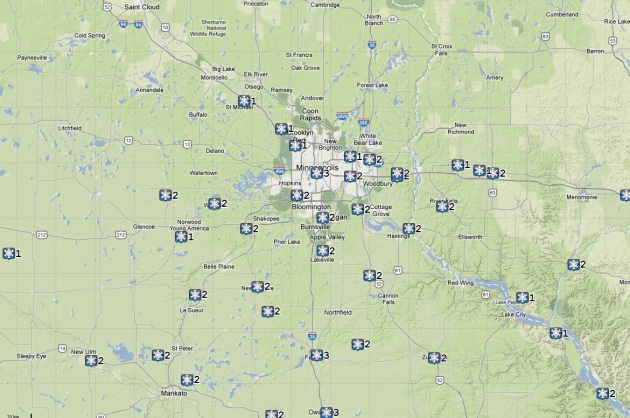
Monday Snow Totals Across the Twin Cities
The Clipper that rolled through PM Sunday-AM Monday across the Twin Cities was responsible for another couple/few inches of snow as well.
Fresh Snow
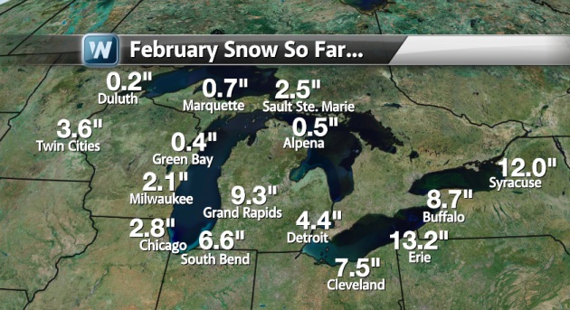
One thing about fresh snow is that it really brightens the landscape doesn't it? I have to admit, I actually kind of like not having to stare at ugly brown snow piles. The image below suggest how much snow we've seen since the start of the month! Keep in mind that snow tallies from Sunday-Monday haven't been added into the data below.
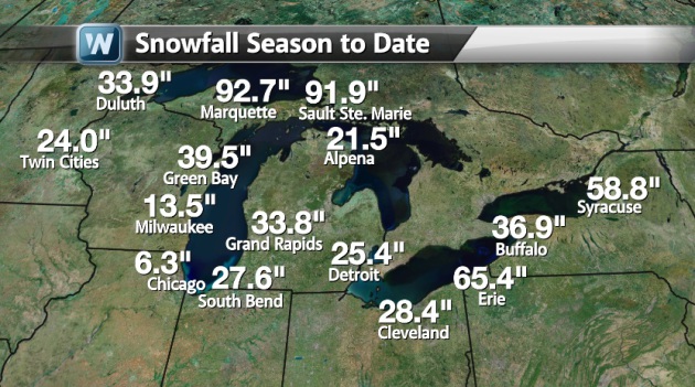
Snow Season to Date
Interestingly, we've seen nearly half the seaonal snow in Chicago so far this month and more is on the way!
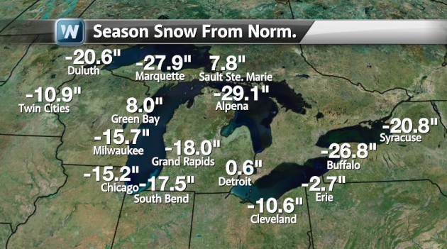
Seasonal Snow Deficit
Despite the recent snowfall as of late, we're still quite a bit behind schedule. There are still several spots with large season snow deficits. It appears that we'll be making up for lost time through the rest of the week and potentially again late weekend.
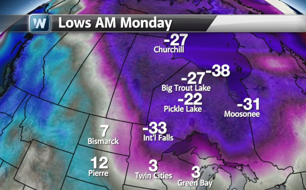
Cold Blog Steers Clippers
Low temperatures Monday morning revealed the clipper storm track pretty well. These fast moving (fairly week) systems are riding the edge of the Arctic air, which is bottled up north of the Great Lakes and around the Hudson Bay.
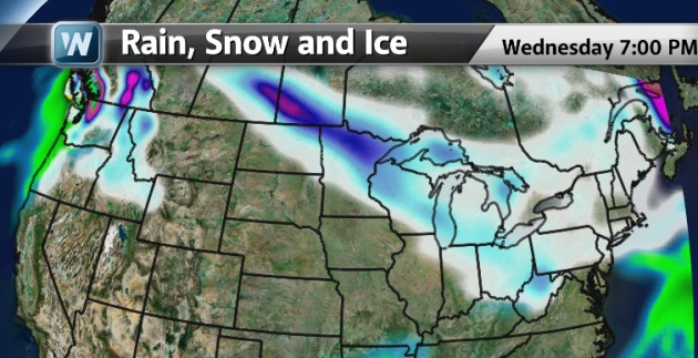
Clipper-Fest Continues
We're not quite done with
clippers just yet. We've got at least 2 more before the weather pattern
chances this weekend. The image below suggests the additional snow from
PM Monday-PM Wednesday. The darker blue across northern Minnesota would
suggest the possibility of nearly 4" to 6" through that time.
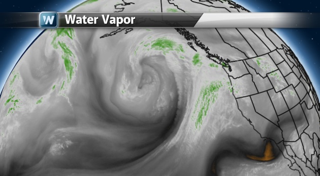
Weekend Storm System...
Take a look at the storm system
over the Pacific Ocean. This is going to be the next system that makes
waves across the mid-section of the nation by late weekend/early next
week.
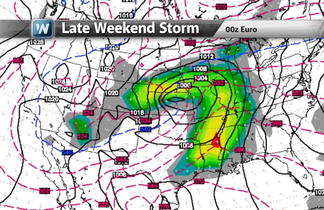
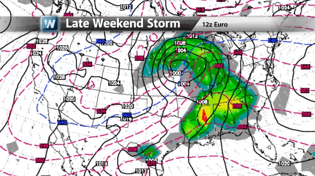
Late Weekend Storm
Here's the storm progged by late
Sunday/AM Monday over the middle part of the country. Note the heavier
snow swath on it's northwestern flank. This could bring
shovelable/plowable snow from the Central Plains to the Great Lakes.
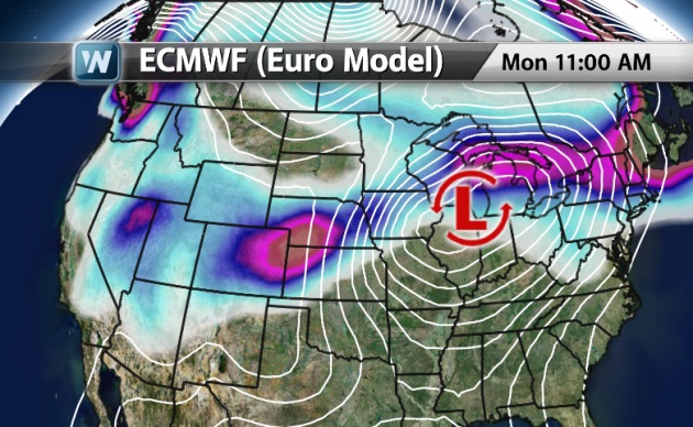
Differences in Model Runs
It is important to keep in mind
that this is a developing storm and the forecast WILL CHANGE!!! The
image below was the 6pm Sunday ECMWF model run.
The image below shows the same
storm, but this is a little newer run from 6am Monday... The other thing
we'll have to keep an eye on is the severe weather potential across the
Lower Mississippi Valley.
Thanks for checking in and have a great rest of you week!
Don't forget to follow me on Twitter @TNelsonWNTV