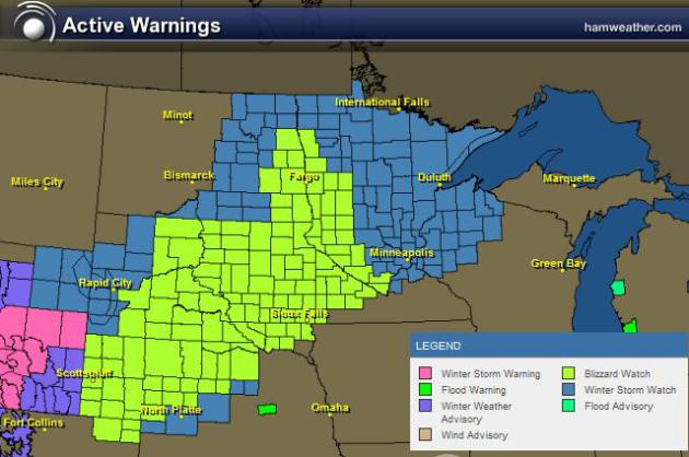
A large chunk of the Upper Midwest has been put under WINTER WEATHER HEADLINES including BLIZZARD WATCHES. A fairly intense area of low pressure will blow into the Upper Mississippi Valley region by the weekend with strong winds and wintry precipitation. At this point, the heaviest snowfall looks to fall from portions of northwestern Nebraska to central/eastern South Dakota, eastern North Dakota and into central and northern Minnesota, where 6" to 10"+ of snow will be possible. Strong winds on the backside of the low will gust to near 45mph and create whiteout conditions across the Dakotas and far western Minnesota.
Probability of at Least 4" of Snow on SUNDAY
Again, at this point, it still appears that the heaviest will just miss the Twin Cities. The NWS probability of at least 4" of snow on SUNDAY are at 70% across central and northwestern MN.
Probability of at Least 8" of Snow on SUNDAY
Here's the NWS probability of at least 8" of snow on SUNDAY. Note there is still a small 70% near the SD/ND/MN border. The 10% does not fall in the Twin Cities.
Probability of at Least 12" of Snow on SUNDAY
The percent chance of at least 12" of snow on SUNDAY drops down to just 10% across northwestern MN.
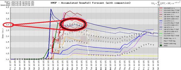
Slop Storm for MSP??
To be honest, there is still quite a bit of uncertainty with weather models right now. Some have heaviest snow band across northwestern Minnesota, while some try to bring it through the northern Twin Cities metro. Here's a look at a few different weather models for the Twin Cities. I've circled the "MODEL AVERAGE" which suggests around a few inches of slop. Keep in mind that it also appears there will be some sleet/rain/freezing rain possible. Total precipitation (liquid) from the storm could be near 1" for some!
MODEL AVERAGE:
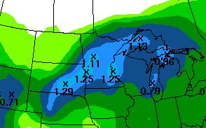
Waterlogged Storm
Here's the latest HPC 3 day precipitation forecst. Note several maximums there exceeding 1" - again from central Minnesota and southeast, snowfall amount could be cut down quite a bit due to warmer air wrapping into the system. That would change precipitation over to Rain/Freezing Rain and Sleet!
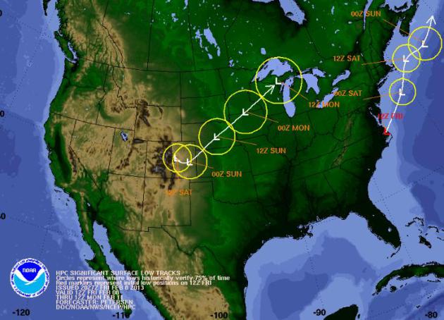
Still a Developing Storm...
I'm hoping that we'll get a little more clarity with the next set of model runs later this evening.... stay tuned!
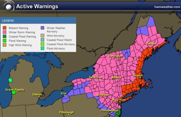
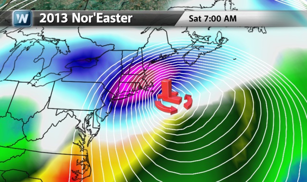
Historic Nor'Easter Continues...
Wild wind and snow surrounding the historic Nor'Easter of 2013 will begin to wind down through PM Saturday and Sunday. Post storm, there will be lots of cleanup, which will likely take days/weeks to remove nearly 2ft. to 3ft in places. Near hurricane force wind gusts and the shear quantity of snow will make for a number of power restorations that will likely be still ongoing through next week.

...A POTENTIAL HISTORIC WINTER STORM AND BLIZZARD IS EXPECTED TO DROP AROUND 2 FEET OF SNOW THROUGH SATURDAY...
** STORM TOTAL SNOWFALL ACCUMULATIONS OF 1 TO 2 FEET...WITH
LOCALLY HIGHER AMOUNTS ARE POSSIBLE ACROSS MUCH OF THE NORTHEAST. THE
HEAVIEST SNOW IS FORECAST TO FALL ACROSS PARTS OF EASTERN
MASSACHUSETTS...CONNECTICUT AND RHODE ISLAND WHERE SNOWFALL AMOUNTS
HIGHER THAN 2 FEET ARE POSSIBLE. IN ADDITION TO THE HEAVY SNOWFALL...
WIND GUSTS AS HIGH AS 70 MPH ARE POSSIBLE...ESPECIALLY NEAR THE COAST.
THIS WILL RESULT IN BLIZZARD CONDITIONS WITH DRIFTING AND BLOWING SNOW
ACROSS MUCH OF SOUTHERN NEW ENGLAND INTO SATURDAY. TRAVEL CONDITIONS
WILL BE EXTREMELY HAZARDOUS IF NOT IMPOSSIBLE. **
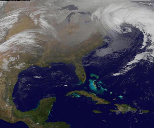
2013 Nor'Easter
Image courtesy NASA
Why So Intense?
This Nor'Easter was actually the
result of two low pressure systems merging near Cape Cod. The northern
low tracked through the Great Lakes region with heavy snow tallies near
12". The southern low tracked across the Gulf Coast States with heavy
rain and even a few severe storms. The image below was from Friday
afternoon just before the two storms merged. Note how intense the
southern low appeared to be... This helped to churn copious amounts of
Atlantic moisture inland. The northern low provided a shot of colder
air, which helped keep that all important rain/snow line mostly
off-shore for most everybody!
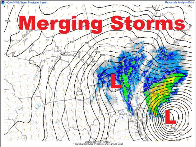
Friday Night Merge...
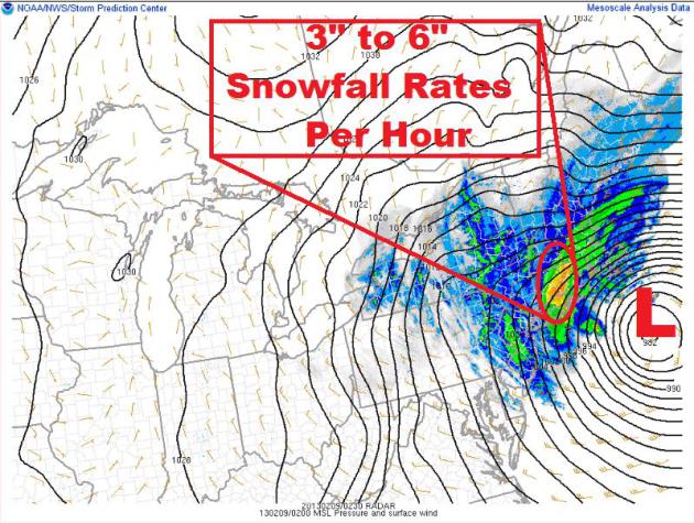
Not sure I've ever seen a storm
like this! There were reports of thundersnow and 3" to 6" snowfall rates
PER HOUR! The image below was the Nor'Easter as it was really kicking
into high gear with heavy snow and wind gusts to near hurricane force
over eastern Mass.
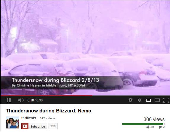
THUNDERSNOW!!
I've only experienced
thundersnow once maybe twice in my life... it's pretty awesome! Take a
look at this video out of NY, thanks to Christine Heeren
(thrillcats) out of Middle Island, NY:
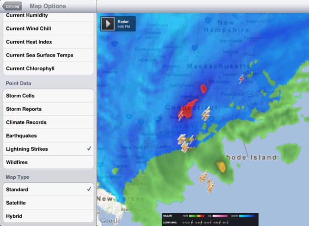
Thundersnow on Radar
Even radar was picking up on thundersnow! The little lightning icons below showed where lightning was being picked up by radar.
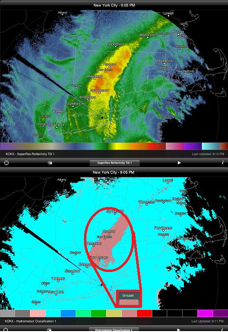
Dual Pol Radar Upgarde
Geek moment... I thought this
was pretty neat. There were reports of SLEET mixed in with heavy snow
during the height of the even over parts of CT. Flipping over the the
Hydrometeor Classification mode, it was actually suggesting SLEET in the
areas that were reporting sleet! Pretty cool!
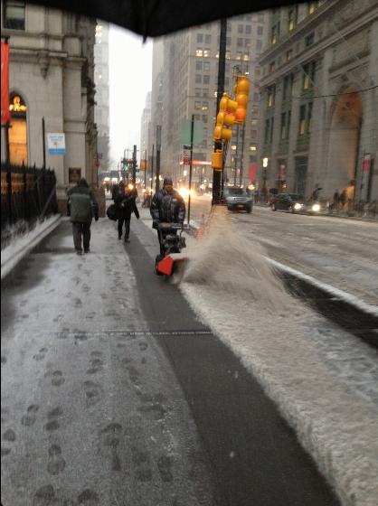
This is what it looked like in
NYC as the snow started Friday afternoon. Thanks to my good friend and
old hockey teammate, Jamie Steinert, for this picture.
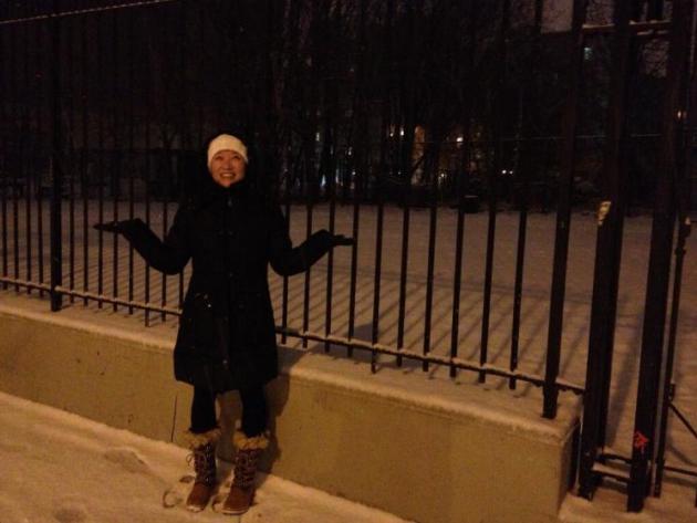
Thanks to my good friend Peter Brooks for this picture below. Here's Lainey Yang enjoying the snow in NYC Friday night!
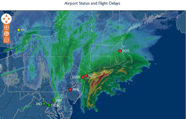
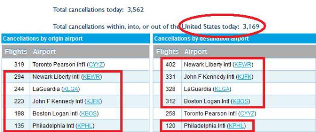
New England Closed Until Further Notice
A number of cities in the Northeast basically 'shut down' in advance of this storm. Ground and air travel halted Friday. The images below from Flightaware.com showed over 3,000 flight cancellations across the nation on Friday, most of those in the Northeast due to the massive storm!
A Storm of Historic Proportions... 2013?
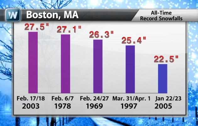
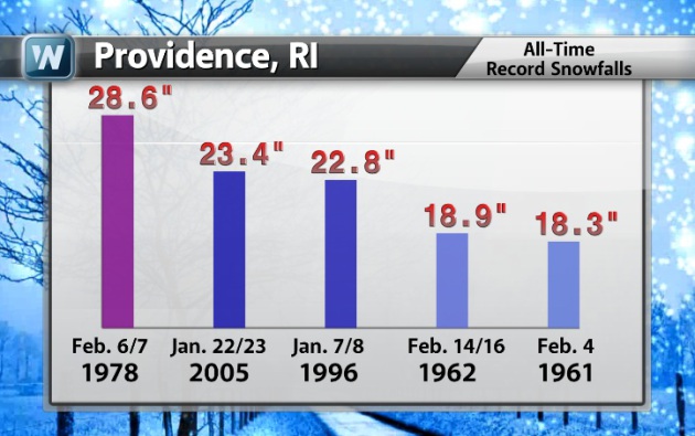
This storm definitely has the potential to dump record snow amounts in quite a few areas. Here are the top 5 storm totals for Providence, RI and Boston, MA. Interestingly, the February 5th-7th, 1978 storm ranks as the all-time greatest snow storm in Providence, RI at 28.6". Boston, MA had it's 2nd largest snow storm during that storm at 27.1". This storm certainly has the potential to meet OR exceed some of the top 5 tallies listed below!
Boston Snow Stats...
Big snow has eluded the Boston, MA region over the last couple of
winters. In fact, the last time we've seen a 12" snow storm was back in
2011. January 11th that had 14.6" !! By the way, the biggest snow
event last winter was a whopping 4.4"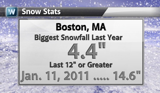
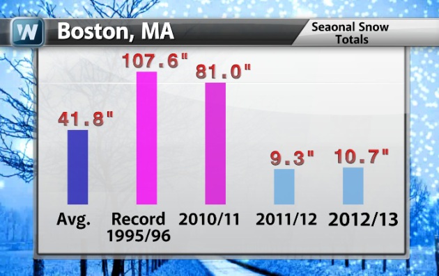
Boston Snow Stats Continued...
Here are some other Boston snow stats. Note the measly 9.3" seasonal snow total last winter!
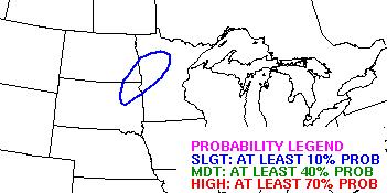
Weekend Storm
Stormy Scenario
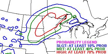
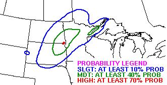
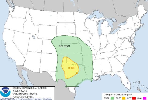
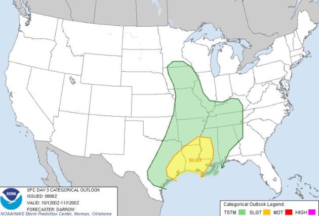
This storm system will also have the capability of producing strong to severe thunderstorms across the south Saturday and possibly Sunday. The Storm Prediction Center has issued a SLIGHT RISK of severe weather for parts of Texas on Sunday. Stay tuned for more.
Saturday Threat
Sunday Threat
Thanks for checking in, have a great weekend ahead!
Don't forget to follow me on Twitter @TNelsonWNTV