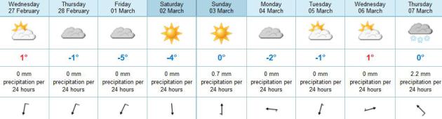
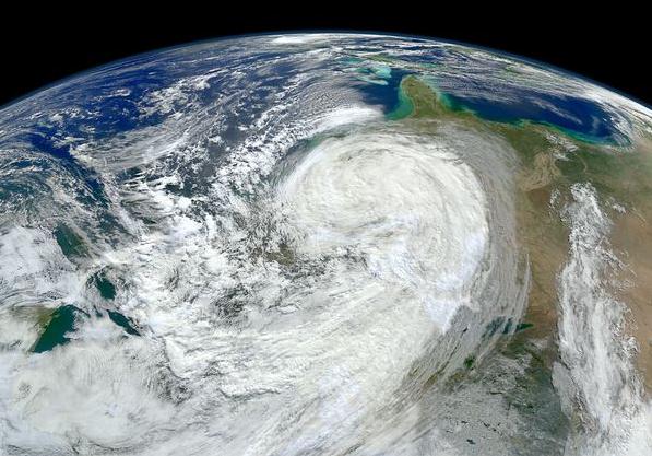
Holding Pattern
Meteorological spring kicks off Friday, March 1.
Forget the calendar - as far as the atmosphere is concerned - spring is
48 hours away. Historical weather data shows the coldest 90 days of the
year, on average, are from December 1 to March 1.
Feeling better yet? We've picked up over 2 hours
and 20 minutes of daylight since December 21. A higher sun angle means
the odds of subzero weather drop off rapidly in March. That said, snow
is on the ground over 54 percent of the USA, which will act as a brake
on any warming in the weeks ahead. I still maintain that spring will
come reluctantly this year, which may be good news.
Why? It should mean larger north-south
temperature contrasts across America, helping to spin up bigger, wetter
storms, taking the edge off our drought.
In theory.
Yesterday's inversion (warming temperatures with
altitude) coupled with light winds lead to a rare February air
pollution alert. How long can you hold your breath?
No big storms; Monday's clipper may brush us
with wet snow Monday; a few inches south of MSP. On the blog: keep
expectations for March warmth low. A negative phase of the NAO should
mean a cooler, stormier month.
More slush anyone?
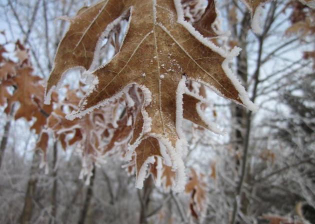
* photos of hoar frost above from WeatherNation TV producer D.J. Kayser, taken at Watab Creek Park near Sartell.
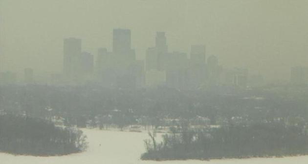
Smog - Minneapolis Style. This midday Tuesday webcam
frame-grab was courtesy of KARE-11, a combination of fog and smog
trapped in the lowest few hundred feet of the atmosphere by light winds
and an inversion (warming temperatures with altitude).
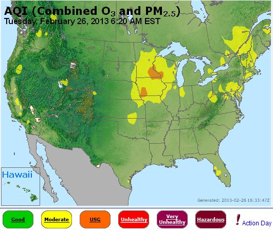
Late Winter Smog. Yes, this is a bit unusual for
late February, but with major storms tracking well south/east of
Minnesota and a weak area of high pressure producing clear to partly
skies and light winds overhead, conditions are favorable for inversions,
which allow man-made pollutants to accumulate near ground-level, posing
the greatest risk to seniors, and people with heart/respiratory
problems. Map from 6:20 am yesterday courtesy of
AIRNow and the EPA.
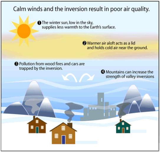
What's An Inversion? The Salt Lake City office of the National Weather Service has a
good explainer
describing how inversions can form. They're even more likely in
mountainous areas, which can create a "bowl effect", hills and mountains
helping to trap pollutants near the ground, especially when
temperatures are warming with altitude. Salt Lake City has seen an
unusually high number of smoggy days this winter due to inversions: "
On
most days, the temperature of air in the atmosphere is cooler
the higher up in altitude you go. This is because most of the
suns energy is converted to sensible heat at the ground, which in
turn warms the air at the surface. The warm air rises in the
atmosphere, where it expands and cools. Sometimes, however, the
temperature of air actually increases with height. The situation
of having warm air on top of cooler air is referred to as a temperature
inversion, because the temperature profile of the atmosphere is
"inverted" from its usual state. There are two types of
temperature inversions: surface inversions that occur near the
Earth's surface, and aloft inversions that occur above the
ground. Surface inversions are the most important in the study of
air quality."
Winter Air Pollution Episodes. Winter smog is most
likely under high pressure bubbles, when winds are light and natural and
man-made pollutants can collect near the ground. Having snow on the
ground cools the lowest few hundred feet of the atmosphere, sharpening
inversions, trapping even more crud. Details in today's
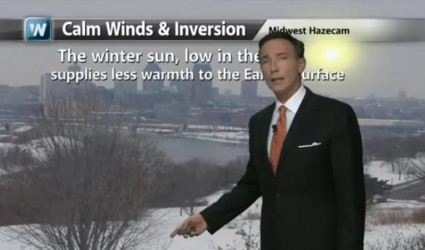
2.30 YouTube edition of Climate Matters: "
An
air pollution health alert was issued Tuesday for folks in the Twin
Cities and Rochester. Meteorologist Paul Douglas has more on what causes
this winter smog."
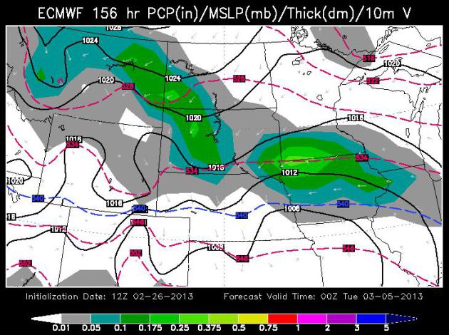
Quiet. No weather headaches or drama thru the middle
of next week. ECMWF data shows a cooling trend Friday and Saturday,
then a rebound back up to near freezing from Sunday into most of next
week. Monday's clipper will probably sail south of MSP; another chance
of light snow next Thursday.
A Near-Clipping. The ECMWF model (WSI) shows a weak
clipper passing south of the Twin Cities Monday, a potential for a few
quick inches along the I-90 corridor of southern Minnesota.
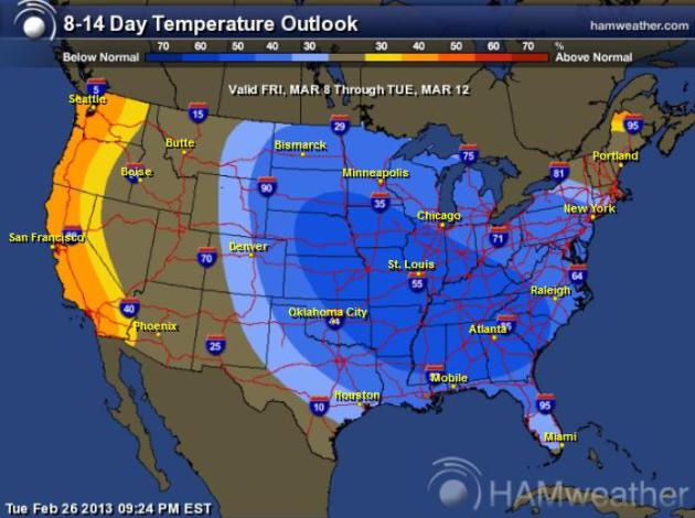
Cold Start To March. After near-normal temperatures
during the first week of March temperatures cool off by the second week
of March, cooler than average weather east of the Rockies between March
8-12. No early spring this year. Map above: Ham Weather.
The White And Windy City. NOAA data shows 4-6"
snowfall amounts over much of Chicago, as much as 10" for Waukegon and
8" for Milwaukee - the biggest snowfall of the winter so far, what has
been a very slow winter for snow-lovers in Chicago.
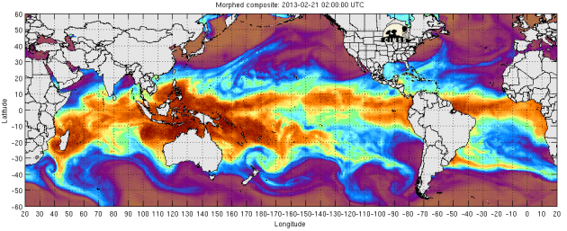
Relief At Last? The pattern appears to be shifting; more Pacific moisture reaching the USA. Here's an excerpt of a story at
Discover Magazine: "
As
I write this late Saturday night, clouds are thickening over the Front
Range of Colorado, where I live, and weather models are predicting
more than a foot of snow in some places. And this is just the first of
three storms that are predicted to blow through Colorado through
Thursday. As the image above shows, we can thank a veritable atmospheric
fire hose out in the Pacific that is spewing precipitable water at the
West coast, and thereby helping to spawn storms..."
Turbulence Ahead For Weather Satellites. There may
be a gap in coverage - which could (in theory) impact the U.S. model
forecast accuracy in the years ahead. Here's an excerpt from
National Geographic News: "
Like a celestial version of Pixar's industrious robot Wall-E, environmental-monitoring satellites
continually whiz overhead, quietly performing their allotted tasks of
taking data and beaming the information down to climate researchers and
weather forecasters. But a recent U.S. Government Accountability Office (GAO) report
highlights the fact that this monitoring network—which weather
forecasters and climate researchers rely on—is in trouble. That's
because these U.S.-owned satellites are aging, and there are serious
concerns about whether their replacements will be ready by the time they
start to break down, said J. Marshall Shepherd, president of the American Meteorological Society and a professor at the University of Georgia in Athens..."
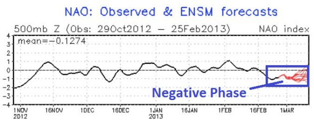
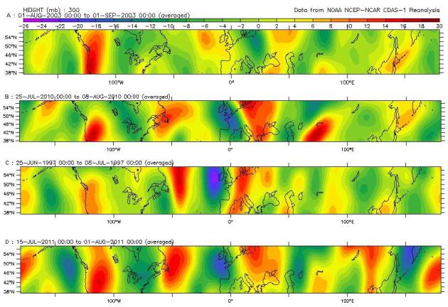
Negative Phase Of NAO. The North Atlantic
Oscillation has been negative for roughly 1 week, meaning a greater
potential for Canadian air to surge south into the USA. Strong positive
phases correlate with a strong zonal flow from the Pacific (what we
experienced last March when the USA saw record-shattering heat). A
negative phase of the NAO correlates with stormier, colder weather,
especially east of the Rockies. A negative phase of the NAO is expected
to linger into mid-March. No early spring this year, at least not for
Minnesota, the Upper Midwest, and most northern cities of the USA.
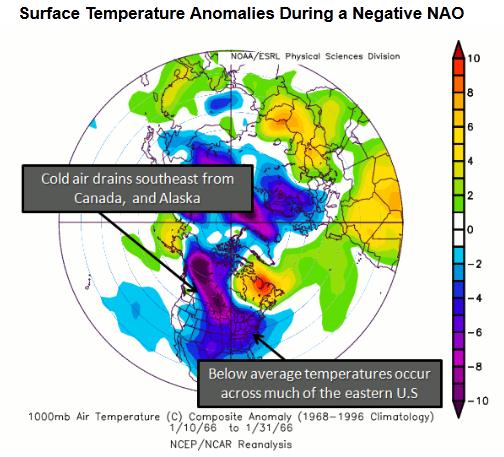
NAO: Negative Phase. This graphic from NCEP/NCAR
shows average temperatures anomalies of a negative phase of the NAO,
Canadian air making a straight shot at the USA; more waves (dips and
bulges) in the jet stream, capable of pulling polar air south, spinning
up major storms in the process.
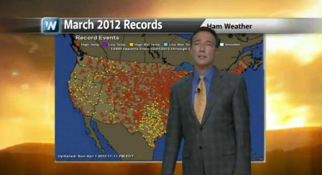
2012 and 2013: Meteorological Apples and Oranges.
Last year at this time snow was on the ground over only 23% of the USA,
with a powerful west to east wind flow, zonal winds from the Pacific,
which warmed us up into the 70s and 80s in March. Nearly 14,000 heat
records in March 2012, a taste of early summer in late winter! Don't
expect a rerun this year. A negative phase of the NAO (North Atlantic
Oscillation) is keeping mild, Pacific air from sweeping across North
America - I expect a parade of cold fronts well into March. But this may
be a good thing (in terms of the drought). A more vigorous north-south
temperature contrast may set the stage for more vigorous storms, capable
of pulling moisture out of the Gulf of Mexico, helping to ease the
drought, especially over the Midwest. Details on
today's climate overview: "
Meteorological
spring starts Friday, March 1st, but for most of the nation it will
still look and feel like winter. Have you seen Amarillo, TX today?
This is a sharp contrast from a year ago. Meteorologist Paul Douglas
looks back at the record busting heatwaves last March and explains why
he's not expecting a repeat this year."
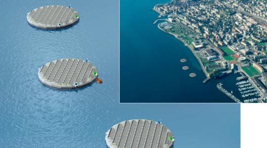
Energy Company To Test Floating Solar Islands. Now here's a novel idea; details courtesy of
gizmag.com: "
Swiss
energy company Viteos has announced that it is to build three floating
solar arrays on Lake Neuchâtel. Viteos will work with tech company and
"energy enabler" Nolaris to build the 25-m (82-ft) diameter islands,
each with 100 photovoltaic panels..."
Putting Out A Newspaper Sans Power. We take so many things for granted, including the power necessary to keep all our tech running, 24/7. Here's an excerpt of a
harrowing story
from St. Cloud Times Executive Editor John Bodette outlining the
difficulties in getting a newspaper published when (most) of the power
goes out: "
Good morning, St. Cloud area. I’m never taking
electricity for granted again. I have said this before, but I’m saying
it again. About 8:20 p.m on Feb. 16, we began losing power in the
Times Media building. Apparently, a transformer went out in our
northside neighborhood, causing an outage for thousands of customers,
including us. Xcel told us that it would take until 1 a.m. to finish
repairs. However, our deadline for the Sunday edition is 11:10 p.m.,
and we had loads of news pages in progress when the partial outage
began..."
The Worst Foods For Sleep? So many of us are tossing and turning (and worrying) every night - here's an article that caught my eye from
Huffington Post: "
A glass of warm milk,
a cup of chamomile tea, a few slices of tryptophan-laced turkey breast
-- a number of foods are at least rumored to help us drift off to
sleep. But, besides the obvious (hello, 4 p.m. Starbucks run), could
there be foods that are actually keeping us up at night? For the most
part, the research surrounding sleep and diet focuses on how your sleep
patterns affect what -- and how much -- you eat, says Kelly Glazer
Baron, Ph.D., M.P.H, a sleep researcher and neurology instructor at
Northwestern University's Feinberg School of Medicine. We know that too
little sleep clouds our food judgement and that the most sleep-deprived among us are likely to serve ourselves larger portions. We also know that both too little and too much sleep can lead to weight gain, for the reasons above and more..." (image above:
MyZeo.com, which has 13 surprising facts about insomnia).
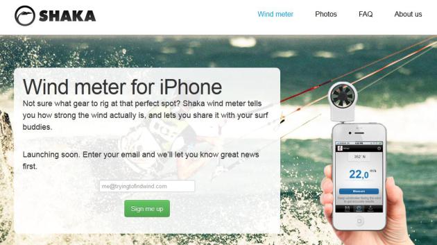
A Wind Meter For Your iPhone? Yes, this may very
well complete me. I'll be the envy of my peers the next time I go wind
surfing, or paragliding, or bungee jumping. But will it work on my
couch? Details
here.
Is iWatch Gesture Control How Steve Jobs "Cracked The Code of iTV?"
Calling Dick Tracy - he wants his watch back. Not sure I want to be
checking e-mail on my watch, but the (alleged/rumored) watch may be a
means to an end, according to this article at
Gizmag: "
In Walter Isaacson's biography of Steve Jobs, the late Apple CEO is quoted as saying that he finally “cracked the code” of an Apple TV set.
“It will have the simplest user interface you could imagine,” Isaacson
quoted Jobs. “I finally cracked it.” What if Jobs’ secret was Apple’s
rumored smartwatch? And what if that secret involved hands-free 3D
gesture control? Not long ago, the internet was abuzz with rumors of an Apple smartwatch (iWatch?).
Most of us have been focusing on the wearable device as an extension
of an iPhone. Flexible touchscreen, voice control, and some version of
iOS. Think Pebble on Cupertino-made steroids...."
Climate Stories...
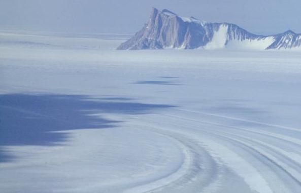
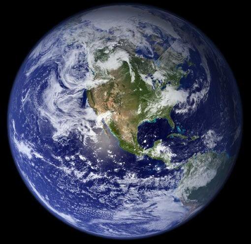
Polar Regions Will See More Snow Over Next Century, Less Everywhere Else.
Snow less often, at our latitude, but when it does snow a better chance
of extreme snow/blizzard conditions, especially if you live near the
east coast. Here's an excerpt from
redOrbit: "
A newly-developed National Oceanic and Atmospheric Administration (NOAA) climate model predicts that increasing carbon dioxide (CO2)
levels will lead to less snowfall in most areas of the world –
including the United States – over the next 100 years. In fact, research
conducted by Sarah Kapnick of the Princeton University Atmospheric and
Oceanic Sciences (AOS) program and Thomas Delworth, a senior physical scientist at the NOAA’s Geophysical Fluid Dynamics Laboratory (GFDL),
forecasts that only the polar regions and the Earth’s highest altitudes
will receive more snow over the next century. “The decline in snowfall
could spell trouble for regions such as the western United States that
rely on snowmelt as a source of fresh water,” Catherine Zandonella, Office of the Dean for Research at the New Jersey-based university, reported on Friday..." (photo above: NASA).
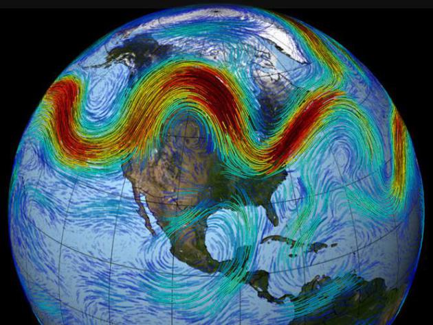
Global Warming May Cause Extremes By Slowing Planetary Waves.
I've mentioned this a few times, the tendency for weather patterns to
become "stuck", meaning more intense droughts and a greater potential
for flooding as storms hover over one area - longer. Here's an excerpt
of a story at
Reuters: "
Global
warming may have caused extreme events such as a 2011 drought in the
United States and a 2003 heatwave in Europe by slowing vast, wave-like
weather flows in the northern hemisphere, scientists said on Tuesday. The
study of meandering air systems that encircle the planet adds to
understanding of extremes that have killed thousands of people and
driven up food prices in the past decade.
Such planetary air flows, which suck warm air from the tropics when
they swing north and draw cold air from the Arctic when they swing
south, seem to be have slowed more often in recent summers and left
some regions sweltering, they said.
"During several recent extreme weather events these planetary waves
almost freeze in their tracks for weeks," wrote Vladimir Petoukhov,
lead author of the study at the Potsdam Institute for Climate Impact
Research in Germany..."
Weather Extremes Provoked By Trapping Of Giant Waves In The Atmosphere. Here is an excerpt of the actual paper referenced above, at the
Potsdam Institute For Climate Impact Research: "...“
What
we found is that during several recent extreme weather events
these planetary waves almost freeze in their tracks for weeks.
So instead of bringing in cool air after having brought warm
air in before, the heat just stays. In fact, we observe a
strong amplification of the usually weak, slowly moving
component of these waves,” says Petoukhov. Time is critical
here: two or three days of 30 degrees Celsius are no problem,
but twenty or more days lead to extreme heat stress. Since many
ecosystems and cities are not adapted to this, prolonged hot
periods can result in a high death toll, forest fires, and
dramatic harvest losses.
Anomalous surface temperatures are disturbing the air flows
Climate change caused by greenhouse-gas emissions from
fossil-fuel burning does not mean uniform global warming – in
the Arctic, the relative increase of temperatures, amplified by
the loss of snow and ice, is higher than on average. This in
turn reduces the temperature difference between the Arctic and,
for example, Europe, yet temperature differences are a main
driver of air flow...."
Can Accountants Succeed On Climate Where Others Have Failed? Here's a snippet of an interesting story at
National Geographic: "
This past week the Government Accountability Office, the federal government’s independent auditor and watchdog agency, added climate change to its list of “high-risk” threats to the nation’s fiscal health. “Climate change creates significant financial risks for the federal government,” the GAO report said.
“The federal government is not well positioned to address the fiscal
exposure presented by climate change, and needs a government wide
strategic approach with strong leadership to manage related risks.” And
for anyone concerned about getting the government to act on climate
change, that raises a tantalizing question: Can accountants succeed
where scientists and the environmental movement haven’t?"
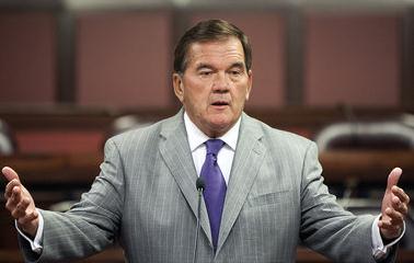
Republican Tom Ridge: "Climate Change Is A National Security Issue." Here's an excerpt of a story that resonated with me from
pennlive.com: "...
The
U.S. national security community, including leaders from the military,
homeland security, and intelligence, understand that climate change is
a national security threat,” Ridge said. “They're not talking about
whether or not it is occurring – it is," Ridge said. "They're talking
about addressing the problem and protecting the American people. It's
time Washington does the same.” Ridge, a former Homeland Security
secretary, appeared in Washington as part of an effort by the
Partnership for a Secure America, a bipartisan foreign policy group. The 38 foreign policy leaders signed an open letter arguing the national security threat of climate change..."
Photo credit: "
Former Pennsylvania Gov. and former Homeland Security Secretary Tom Ridge." DAN GLEITER, The Patriot-News
Long Term Climate Change Trends Worry Experts. Here's a clip from a story at
Indiana Public Media: "...
Indiana
University Professor of Atmospheric Science Sara Pryor is a lead
author of the section that looks at how climate change could affect the
Midwest, specifically. She says farmers could see future crops hurt by
droughts similar to the ones the region saw last summer. “Both corn and
soybean yields are decreased if we have warm summers, and if we have
dry summers,” she says “So, given that our climate change projections
are that the Midwest will become warmer and dryer in the summer, we
certainly have expectations that crop yields will decrease.” She says if
current trends continue, the growing region for crops will move
gradually north. “Because our region is relatively flat, for one degree
of warming, a crop has to move; all plants have to move, about 100
kilometers to keep at that same temperature.” However, she says, the
farther north in the Midwest you go, the worst the soil quality gets..."
Can NASA Stop Global Warming? I'm skeptical that any
technology can stop the warming altogether, although we may be able to
launch solutions that slow the rate of warming. Here's an excerpt from
Project-Syndicate: "...
Obama
should challenge NASA to address one of today’s most important issues,
global warming, by developing safe, cost-effective technologies to
remove carbon dioxide from the planet’s atmosphere and oceans. This
mission could be accomplished in two phases.During the first phase,
which could be completed by 2020, researchers would identify roughly
10-20 candidate geo-engineering technologies and test them in
small-scale experiments. The second phase would include large-scale
test demonstrations to evaluate the most promising technologies by
2025. Developing these technologies is crucial, given that, over the
last half-century, the concentration of CO2 in the atmosphere has
increased from roughly 320 parts per million to almost 400 parts per
million, heating up the planet and increasing the acidity of the
world’s oceans. At this rate, the concentration of CO2 in the
atmosphere will exceed 450 parts per million in roughly 25 years..."
Climate Change Is Cutting Humans' Work Capacity.
Climate Central has the story; here's an excerpt: "
It’s not just the heat, it’s the humidity that gets you. That’s the conclusion of a new study
that finds climate change has reduced humanity’s ability to work by
making the planet hotter and muggier. That one-two punch has already cut
the world’s working capacity by 10 percent since humans began burning
large amounts of oil, gas, coal and other fossil fuels at the start of
the Industrial Revolution, found the analysis, which was published
Sunday in the journal Nature Climate Change. Researchers at the National Oceanic and Atmospheric Administration
predict that dive will continue, reshaping daily life in the most
populated areas of the planet as climate change intensifies.
By 2050, a
combination of rising heat and humidity is likely to cut the world’s
labor capacity to 80 percent during summer months — twice the effect
observed today...