70% of Nebraska now in exceptional drought, the most extreme designation. Source: NOAA.
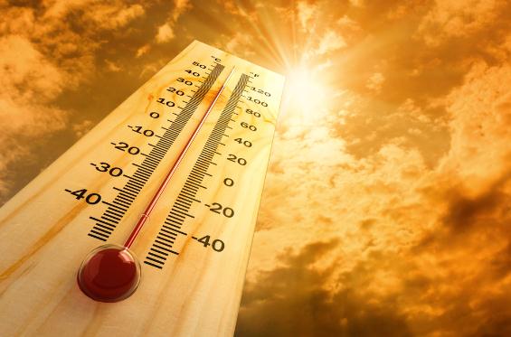
109 F. heat index yesterday at Searcy, Arkansas.
“
Isaac’s rains were like Chapter 1 in the drought relief book,” said
David Miskus, a meteorologist with the National Oceanic and Atmospheric
Administration’s climate prediction center. “We still need a lot more
rain to go here to really eliminate this drought.” - excerpt from a New York Times article on the drought below.
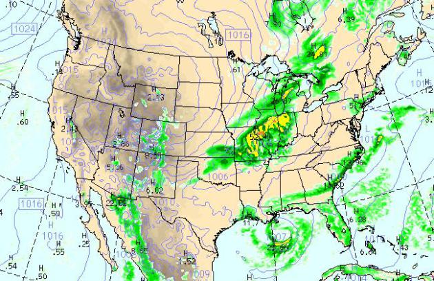
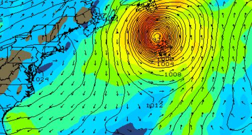
Today's Weather Map.
The WRF model, valid 4 pm, shows badly-needed rain over the Midwest and
Great Lakes, out ahead of the latest surge of cooler, Canadian air.
T-storms bubble up along the Carolina coast, while a tropical depression
sputters over the Gulf of Mexico. Dry weather persists for much of the
western half of the USA.
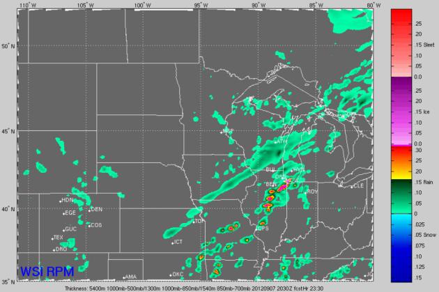
PM Instability Sprinkles.
The high-res, 12 km RPM model (courtesy of WSI) shows a few sprinkles
and very light showers over eastern Minnesota this afternoon; heavier
showers and T-storms pushing into Chicago, capable of sparking delays at
O'Hare and Midway.
"...
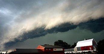
While some parts of the nation were dealing with drought and fire, others were being pummeled by storms.
A freak wind system known as a derecho left 23 dead and 1.4 million
people without power from Illinois to Virginia. Another potent storm dumped
up to 10 inches of rain in Minnesota and in Wisconsin, flooding homes,
breaking records, and prompting a polar bear to escape from a swamped
Lake Superior Zoo. All these storms, heat waves, droughts, and fires
are not one-off events, but a pattern of increasingly extreme weather
that is exactly what global warming models have predicted." - excerpt from a story at The Energy Collective; details below. Photo above: NOAA.
"..
.In providing an overview of the climatological situation, AMS
noted that all of the 10 warmest years in the global temperature
records through 2011 occurred since 1997. For the U.S. as a whole,
there have been twice as many record daily high temperatures as record
daily low temperatures recorded in the first decade of the 21st
century." - from an article on the new, revised AMS (American Meteorological Society) position on climate change; details below.
"...
Cherry pickers ignore the fact that our planet is currently building up heat
at the stunning rate of around 3 Hiroshima bombs per second. Instead,
they focus on short periods of the surface temperature record. This
record bounces up and down from year to year as the ocean exchanges heat
with the atmosphere, meaning that it’s possible to find any short period during a long-term warming trend where temperatures fall briefly." - excerpt from The Conversation below.
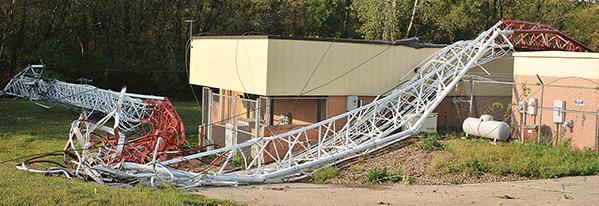
KSMQ Station Operating Again. This is what the
severe storms rumbling across far southern Minnesota earlier this week
did - straight line winds possibly in excess of 70 mph. at times.
The Austin Daily Herald has an update; here's an excerpt: "
Austin
KSMQ TV employees had a hectic day Wednesday after a storm toppled the
station’s broadcast tower early that morning; however, the station is
now back on the air. While the tower itself still lies in shambles, the
station was able to get back up and running at 7:58 p.m. thanks to the
help of other local broadcast stations. “We had great cooperation with
local broadcasters,” Eric Olson, KSMQ president and CEO, said
Wednesday afternoon before the station was again operational. The
fiasco was like a mini TV reunion for Olson and other local TV
executives, many who have not seen each other in years. Initially,
Olson and others thought it could be two weeks before KSMQ would be
operational, so much of the day was spent collaborating with other
stations on a solution."
Photo credit above: "
A portion of a 440-foot transmitter
tower lies draped over a small building near the Riverland Community
College west building Wednesday morning. The tower came down during the
severe storms that swept through Wednesday between midnight and 1 a.m." Eric Johnson/photodesk@austindailyherald.com
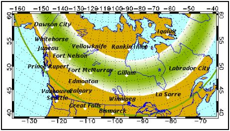
Aurora Forecast. Here's a
good link
to gauge the probability of being able to view the aurora on any given
night, the latest forecasts from the Geophysical Institute at The
University of Alaska, Fairbanks.
* more great aurora links
here.
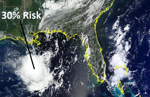
Not Quite As Ominous.
The soggy remains of Isaac, which struck Louisiana (twice) as a
hurricane early last week is still festering over the Gulf of Mexico.
NHC has lowered the odds of reintensification back to tropical storm
status to 30%, down from 50% on Wednesday. Forecasters will watch this
disturbance carefully - it may still drift east over Florida by the
weekend, increasing the odds of heavy rain. Image above courtesy of
NASA MODIS.
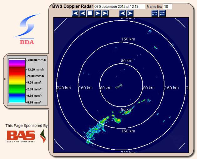
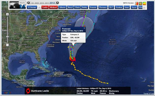
Waiting For Leslie. Here is the
latest radar loop
from the Bermuda Weather Service. The island may endure Category 2
(95-110 mph) winds by the weekend as Hurricane Leslie's eye passes very
close to Bermuda.
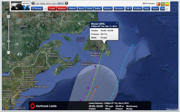
GFS Solution. The GFS solution is slower (and
deeper/stronger), showing a Category 2-3 hurricane 300 miles south of
St. John's, Newfoundland next Wednesday. Other solutions move the
hurricane faster, bringing "Leslie" ashore as early as Tuesday as a
Category 1 storm.
Projected Track of "Leslie".
Models sweep a strengthening Hurricane Leslie 150 miles east of Bermuda
this weekend, brushing the island nation with a 4-8 foot storm surge.
The storm is forecast to strengthen to a Category 2 hurricane, with
sustained winds exceeding 100 mph by the weekend. Map: NHC and Ham
Weather.
A Canadian Hurricane?
Water temperatures over the North Atlantic are unusually warm, some
5-10 F. warmer than average for early September. That may sustain Leslie
as a Category 1 storm unusually far north, with landfall projected next
Tuesday near St. John's, Newfoundland - possibly as a Category 1
hurricane. Map: Alerts Broadcaster.
Bermuda Weather Trivia. more details on Bermuda weather and climatology (and hurricane history)
here.
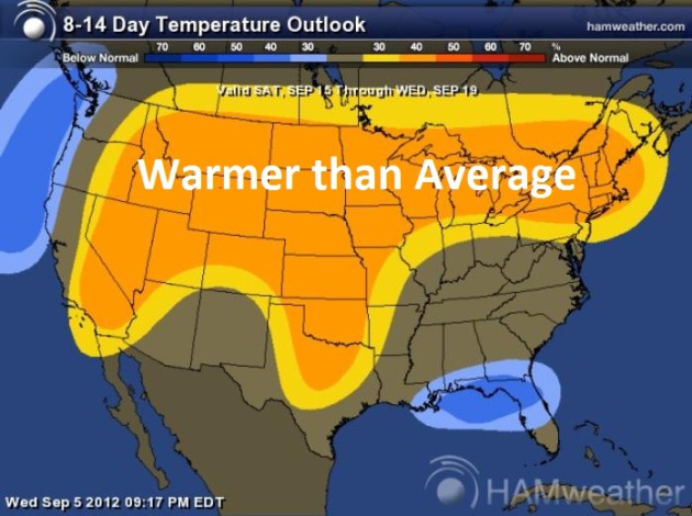
Warm Bias Thru Third Week of September. In spite of a
few blips of cooler air (including cool 60-degree highs for much of
Minnesota today) the trend will be...the same as it's been for the last
15 months across the Upper Midwest: warmer than normal. The 8-14 day
temperature outlook from NOAA CPC shows a warm bias across most of
America. Map: NOAA and
Ham Weather.
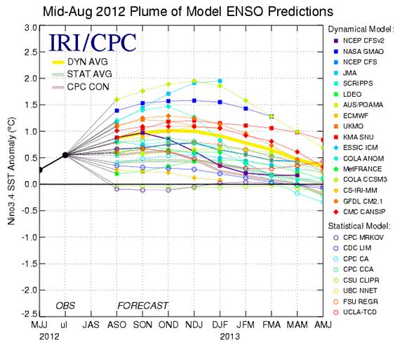
El Nino Conditions Are Likely To Develop During September 2012.
Not sure I'm ready for this. El Nino (warming phases) correspond to a
warm, dry bias for Minnesota and northern tier states. But wait, last
winter was the 3rd warmest, in spite of a La Nina cooling phase? We're
just as confused as you are.
NOAA has more details: "
ENSO-neutral
conditions continued during August 2012 despite above-average sea
surface temperatures (SST) across the eastern Pacific Ocean. Reflecting
this warmth, most of the weekly Nino index values remained near +5 C.
The oceanic heat content (average temperature in the upper 300 meters of
the ocean) anomalies also remained elevated during the month,
consistent with a large region of above-average temperatures at depth
across the equatorial Pacific. Possible signs of El Nino development in
the atmosphere included upper-level easterly wind anomalies and a
slightly negative Southern Oscillation Index."
 Will Winter Return With A Vengeance?
 I
doubt it (based on recent trends) but I reserve the right to be
pleasantly surprised. Here's an excerpt from my (bootleg) copy of the
2012 Farmer's Almanac. Why not. "
After a year of unprecedented warmth – both during the winter and
summer months – the great debate over whether or not Old Man Winter will
return with a vengeance is on. Last winter was the fourth warmest for the contiguous 48 since record
keeping began in 1895, with 24 states experiencing below-normal
precipitation. In fact, California experienced its second driest winter
ever. In only 10 states—chiefly across the nation’s midsection— was
winter precipitation above normal. The situation became critical this past spring and summer with
broiling hot temperatures across much of the country and the most severe
drought conditions the nation has seen in more than 50 years."
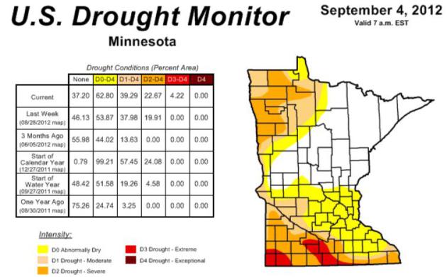
HydroClim Minnesota. Here are some
climate highlights from Minnesota State Climatologist Greg Spoden:
- The U.S. Drought Monitor, released on September 6, places portions
of southwestern and south central Minnesota in the Extreme Drought
category. Many northwestern Minnesota counties, and many of Minnesota's
southernmost counties, are said to be in Severe Drought. In total,
approximately 63% of Minnesota is considered to be in the Abnormally Dry
category or worse.
- The drought situation in northwest Minnesota and in far southeast
Minnesota is the result of an historically dry autumn in 2011, a
snow-sparse winter, and a dry 2012 growing season. The moisture deficits
in southern Minnesota developed rapidly due to very hot and very dry
conditions that begain in late June and continue as of this writing.
Over the past 11 weeks rainfall totals in many Minnesota counties fell
short of average by four or more inches.
This is the climatological equivalent of missing an entire summer's month worth of precipitation. In some south central Minnesota communities, late-summer rainfall deficits are in excess of 6 inches.
- The U.S. Geological Survey and Minnesota DNR report that stream
discharge values are very low at numerous Minnesota reporting locations.
Stream flow values rank below the 10th percentile for this time of year
in some of these watersheds.
- In a September 4 summary, the Minnesota Agricultural Statistics
Service reported that topsoil moisture was 22% Very Short and 41% Short
across Minnesota. The report also indicates that roughly 85% of
Minnesota's corn and soybean crop is in fair, good, or excellent
condition.
This is a significantly higher percentage of favorable conditions than those found in other Corn Belt states.
-
Ample autumn rains are critically needed to replenish soil moisture reserves. Water levels on other hydrological systems (lakes, rivers, wetlands) will rebound only after the soil profile is recharged.
* latest Minnesota Drought Monitor is
here.
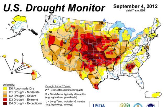
U.S. Drought Monitor. NOAA data continues to show
exceptional drought conditions across the central and southern Plains,
with extreme drought stretching from Nevada to Georgia.
Click here to get more information.
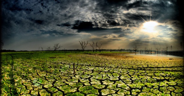
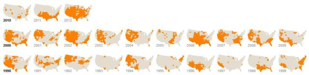 Wide Area Of Nation Still Parched After Storm
.
The New York Times has more on (slight) relief from Isaac, and how much of the USA
is still suffering through the worst drought since the mid-50s. Here's an excerpt: "
The remnants of Hurricane Isaac
that blew through the middle of the country over the weekend softened
the worst drought in decades in some areas, but a large portion of the
nation remains desiccated with ponds still too shallow to water cattle,
fields too dusty for feeding and crops beyond the point of salvage,
meteorologists and agriculture experts said Wednesday. Conditions have, in fact, worsened in some rain-starved regions
untouched by the hurricane’s gray clouds, meteorologists said."
Graphic above: Drought's Footprint.
"More than half of the country was under moderate
to extreme drought in June, the largest area of the contiguous United
States affected by such dryness in nearly 60 years. Nearly 1,300
counties across 29 states have been declared federal disaster areas.
Areas under moderate to extreme drought in June of each year are shown
in orange (above)" Source: New York Times.
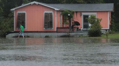
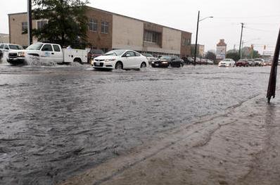 Flash Flood
.
Jennifer Shutte snapped this photo of street flooding in Salisbury,
Maryland Thursday afternoon, the result of slow-moving T-storms dumping
out some 1-2" rains in a short period of time. Details from
WBOC-TV.
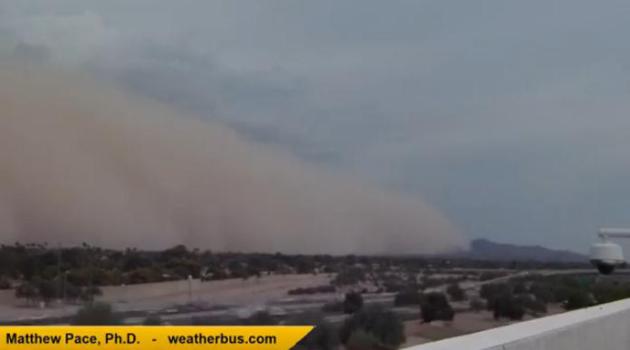 Haboob!
Another massive dust storm swept across Phoenix Thursday, the result of
T-storm downdrafts whipping up sand and dust and suspending 1 mile
overhead. Thanks to Dr. Matthew Pace for shooting some compelling
footage, available on
YouTube.
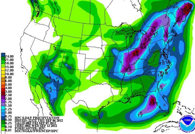
Moisture Imbalance. The 5-Day rainfall outlook
(NOAA HPC) shows some 1-3" amounts from Indianapolis and Toledo to
Detroit, another soggy bulls-eye near Tampa. Monsoon T-storms flare up
over the desert southwest.
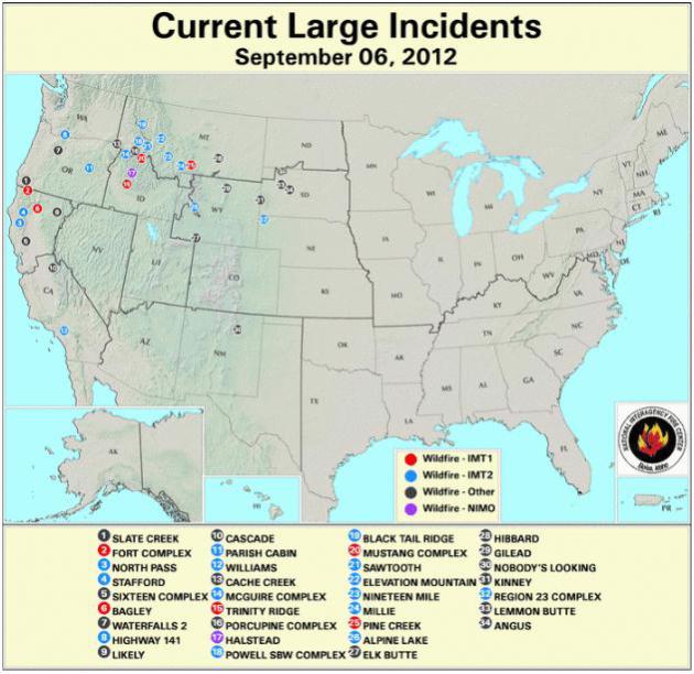
Active Fire Mapping. Here's a web page with updated wildfires around the USA, courtesy of
USDA.
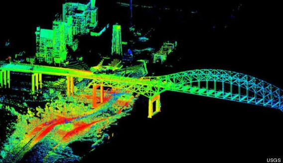
Hurricane Isaac 3-D Satellite Images Show Extent Of Flood Damage. I thought this was fascinating - a story from
Huffington Post and Our Amazing Planet; here's an excerpt: "
Hurricane
Isaac sent sheets of rain from the sky and ocean waters surging
ashore, inundating large regions of the Gulf Coast with devastating
floods last week. Teams of scientists are already on the ground, using
advanced laser-imaging technology to capture the storm's effects in 3D.
Teams with the U.S. Geological Survey are using lidar (short for light
detection and ranging) to help make intricately detailed topographic
maps of the floodwaters Isaac brought
to the hardest hit population centers in Louisiana, Mississippi and
Alabama. The scans capture not only the extent of the flooding, but also
catalog damage to buildings, levees and other structures."
Image credit above: "
A lidar scan, taken from the ground, of New Orleans' I-510 bridge taken on Aug. 31, 2012." USGS.
Hurricane Season Dilemma: To Stay Or To Go. Many
locals take a wait and see attidude, often relying on the category of
the hurricane to decide on whether to evacuate inland or wait it out.
"Category 1? No big deal - I'll take my chances." But Isaac was a
Category 1, a "minimal hurricane" (oxymoron) that produced Category
3-like damage and flooding, especially in the parishes outside of New
Orleans. Here's an excerpt of an article at
nola.com in New Orleans: "
It
was seven years ago that my life changed forever, just as many of us
who were affected by Hurricane Katrina. And it was deja vu last week
when Hurricane Isaac decided to pay us a visit and prolong its stay,
leaving many without power for days, and unfortunately, entire
communities without homes. When my husband suggested that we evacuate, I
originally thought that he was overestimating the severity of what was
then Tropical Storm Isaac. As I watched the newly formed Hurricane
Isaac destroy power lines and homes from the comfort of a family
member’s home the next day, I soon realized we had made the right
decision."
Flood An Underestimated Risk. There is some interesting information, statistics and trends in this article from
Insurance Networking News; here's a clip: "
As
Costa Rica sends rescue teams to an area hit yesterday by a magnitude
7.6 earthquake, risk modelers have more natural catastrophe data to
contend with: flood loss. Flood losses are on a rapid upswing, according
to a report issued today by Swiss Re.
Affecting an estimated 500 million people worldwide annually, the
increase in flood-related claims has been significant, notes Swiss Re’s
new report, “Flood - an Underestimated Risk: Inspect, Inform, Insure.”
According to Swiss Re’s data, in the 1970s annual flood-only related
claims were $1-2 billion; in 2011, insured flood losses amounted to $15
billion." Photo: Dan Anderson, EPA.
 Iowa's Wine Lovers Rejoice Over Crop
. I've never tried a fine Iowa wine. Most of my wine comes out of a box, but I'll give a try - if you say so. Details from
The Des Moines Register: "
The drought may give wine aficionados a rare gift this holiday season. Iowa
grape growers and wine experts say hot, dry weather has concentrated
the grapes’ flavors, which will lead to unusually tasty reds and whites. “The
quality of the crop is fantastic,” said Mike White, a viticulture field
specialist at Iowa State University. “It’s some of best that I’ve
seen.” But some shadows have fallen on the vines. A frost in April
killed much of the grapes. The drought also produced smaller fruit.
White predicts the volume of the grape harvest will fall by 30 percent."
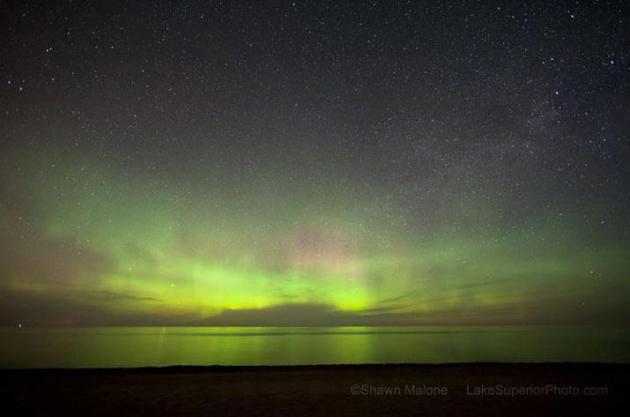
Celestial Magic
One of the (many) things I love about living in
Minnesota: a front row seat to the Northern Lights. Seeing ripples of
red and green race across the northern sky conjurs up a rare, almost
childlike sense of wonder. It's a mind-blowing experience.
There is still no way to predict the Aurora
Borealis in advance, but with recent solar flares the probability of
taking in a dazzling free show just went up.
I've had more luck in autumn than any other
season, but you'll need to get away from metro light pollution, and give
your eyes at least 15 minutes to adjust. Good luck.
A cooler front of Canadian heritage will be
whistling thru the trees today, daytime temperatures stuck in the 60s,
with a few lumpy stratocumulus clouds to convince you that it really is
September. The sun comes out on Saturday; a clipper sparks a few PM
showers east of the St. Croix. Sunday looks sunnier and nicer.
What a shock: no significant rain is in sight.
63 percent of Minnesota is "abnormally dry"; extreme drought pushing
into southern counties.
According to State Climatologist Greg Spoden
"some counties have missed an entire summer month's worth of rain since
late June". No end to warm/dry in sight.
Climate Stories...
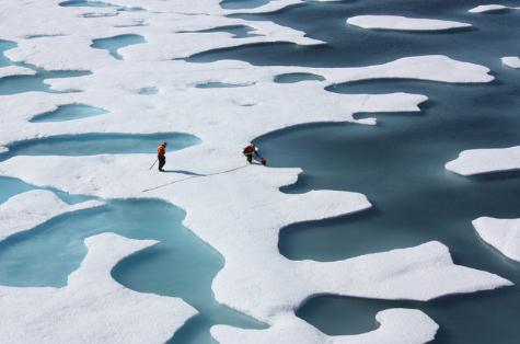
Arctic Ice Melt "Like Adding 20 Years Of CO2 Emissions." The BBC has the story (and video) - here's a clip: "
The
loss of Arctic ice is massively compounding the effects of greenhouse
gas emissions, ice scientist Professor Peter Wadhams has told BBC
Newsnight. White ice reflects more sunlight than open water, acting like
a parasol. Melting of white Arctic ice, currently at its lowest level
in recent history, is causing more absorption. Prof Wadhams calculates
this absorption of the sun's rays is having an effect "the equivalent
of about 20 years of additional CO2 being added by man".
Summer From Hell: Climate Change Makes Its Presence Known.
The Energy Collective has the story; here's an excerpt: "
The
summer of 2012 has come to a close, but it won’t be forgotten anytime
soon. It delivered one extreme weather event after another, from heat
waves to freak storms, wildfires to drought. People lost their homes
and livelihoods, yet even as they try to pick up the pieces, more
powerful weather systems are looming on the horizon. Extreme weather is
a hallmark of climate change. Scientists from the National Center for
Atmospheric Research, the National Oceanic and Atmospheric
Administration, and other leading groups confirm that climate change is
contributing to the frequency and power of 2012’s weather events.
Climate change creates stronger storms, including hurricanes like Isaac,
and more potent heat and drought."
Meteorologists Update Position On Climate Change. The story from
feedstuffs.com; here's a segment of the article: "
Updating a
2007 position statement, the American Meteorological Society released
an updated Statement on Climate Change Aug. 27. In addition to
providing background and a brief overview on how and why the global
climate has changed in recent decades, the statement names human
activities as the main cause of atmospheric and oceanic warming. “There
is unequivocal evidence that Earth’s lower atmosphere, ocean and land
surface warming; sea level is rising; and snow cover, mountain
glaciers, and Arctic sea ice are shrinking,” the statement concludes.
“The dominant cause of the warming since the 1950s is human activities.
This scientific finding is based on a large and persuasive body of
research.”
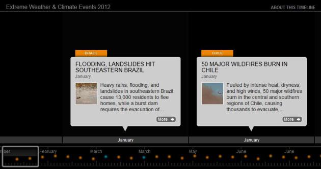
Timeline (Infographic) Showing Extreme Weather, Climate Change Link So Far In 2012. Huffington Post has the story (and timeline): "
As the Gulf Coast assesses damage from Hurricane Isaac, food prices take a hit from the Midwest drought and the West continues to battle wildfires, the World Resources Institute has compiled a timeline of some of the extreme weather and climate events that have hit the world so far in 2012. As WRI's Kelly Levin notes,
"While we have not performed analysis connecting any of these events
to climate change, many of these occurrences are in line with what
scientists have predicted in a warmer world. Plus, the science of attributing extreme events to human-induced warming has improved significantly."
How Do People Reject Climate Science? Here's an excerpt from an article at Australia's
The Conversation: "
In a previous article on The Conversation, Stephan Lewandowsky asked, why do people reject science?
I’m going to take a slightly different angle and consider how people
are able to reject climate science in the face of strong evidence. A
growing body of research has found that when a person’s worldview is
threatened by scientific evidence, they interpret the science in a
biased manner. One issue where this influence is strongest is climate
change. For supporters of an unregulated free market, regulating
polluting industries to reduce global warming is so unpalatable that
they are far more likely to reject that climate change is happening."
Photo credit above: "
In spite of overwhelming scientific
evidence for climate change, people find ways to reject that evidence
if it does not fit with their world view. NASA Goddard Space Flight Center."
Democrats Mention Climate Change Once In Over 80 Speeches. Details from
The Daily Caller: "
CHARLOTTE,
N.C. — Though the 2012 Democratic Party platform declares that the
“national security threat from climate change is real, urgent, and
severe,” it is apparently not urgent and severe enough to merit mention
by speakers at the Democratic National Convention during the past two
days. The Daily Caller reviewed the speech transcripts of the over 80
speakers who took the stage at the Time Warner Cable Arena here in
Charlotte on Tuesday and Wednesday, and only one mentioned climate
change — and even he only mentioned it in passing."