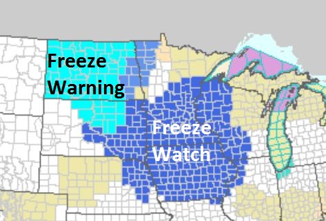
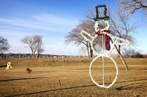
Freeze Watch tonight for most of Minnesota, including the Twin Cities. A frost is likely over the outlying suburbs.
And So It Begins. "
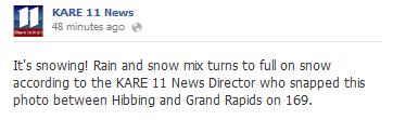
After hail was reported in
Duluth at 7:30 pm (Friday) very light snow has been observed by a fellow
meteorologist a short time ago at 8:20 pm in Grand Rapids, Minnesota!" - e-mail from meteorologist Bryan Karrick.
Freeze Watch. Much of Minnesota will wake up to a
frost or freeze Sunday morning. The immediate close-in suburbs of the
metro may avoid 32 F, but outlying suburbs will come very close to
experiencing the first frost of the season, about a week ahead of
schedule.
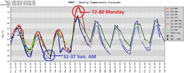
Looking Frostier. Every computer run drops a degree
or so. NOAA (local Twin Cities office) is predicting 35, I'm going 34 at
MSP International, which means 36-38 for the downtowns, but 30-32 at
Lakeville, Stillwater, Anoka and Medina. If you live outside the 494/694
freeway and you want to see your flowers awhile longer, cover them up,
bring them inside, or write them off. Graph: Iowa State.
First Frost/Freeze. The National Weather Service has
issued a Freeze Watch for much of the Upper Midwest, Freeze Warnings
for the Dakotas. The immediate downtowns and close-in suburbs may miss a
frost late tonight, but it's going to be close. Details:
...FREEZE WATCH SATURDAY NIGHT INTO SUNDAY MORNING FOR ALL OF
CENTRAL AND SOUTHERN MINNESOTA AND WEST CENTRAL WISCONSIN...

.A FREEZE WATCH HAS BEEN ISSUED FROM 1 AM TO 8 AM SUNDAY MORNING
FOR ALL OF CENTRAL AND SOUTHERN MINNESOTA AND WEST CENTRAL
WISCONSIN.

LOWS SUNDAY MORNING WILL DROP INTO THE MID 20S TO AROUND 30 OUTSIDE
OF THE URBAN CORE OF THE TWIN CITIES. WITHIN THE URBAN CORE OF THE
TWIN CITIES METRO AREA...TEMPERATURES ARE CURRENTLY EXPECTED TO
REMAIN UP IN THE MID 30S AND FROST MAY BE POSSIBLE EVEN IF
TEMPERATURES REMAIN A FEW DEGREES ABOVE FREEZING.

A COLD DOME OF CANADIAN HIGH PRESSURE WILL BE MOVING IN BEHIND A
STRONG COLD FRONT TONIGHT...AND WILL BE CENTERED ACROSS MINNESOTA
BY SUNDAY MORNING. THIS WILL RESULT IN CLEAR SKIES AND CALM
WINDS SATURDAY NIGHT...WHICH WILL ALLOW TEMPERATURES TO FALL
BELOW 32 DEGREES FOR MUCH OF THE AREA BY SUNDAY MORNING.
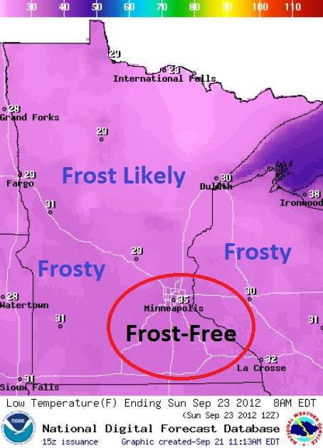
Flirting With Frost. The urban heat island will keep
temperatures about 3-7 F. warmer than greater Minnesota Sunday morning.
The close-in suburbs of the Twin Cities should avoid a widespread
frost, but far outlying suburbs may wake up to a light coating of white
on lawns and fields. Forecast temperatures courtesy of
NOAA.
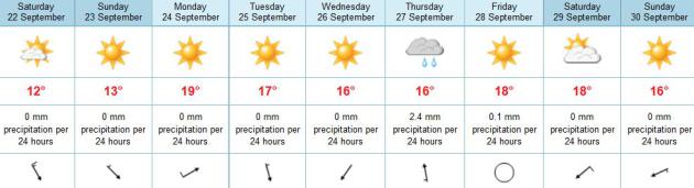
A Dry Spell. With the exception of a little light
rain next Thursday, it's a dry forecast for the next 7-10 days. Highs
next week reach the 60s, the best chance of 70+ highs Monday, again next
weekend. The drought is going to get progressively worse.
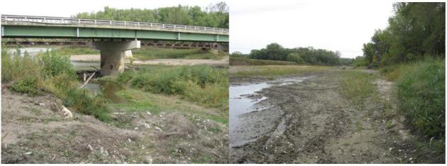
Down To A Trickle. This is, or was, the Raccoon
River at Booneville, Iowa - just southwest of Des Moines. There used to
be a river there. Thanks to Sandi Smith for sending this to
WeatherNation TV meteorologist Bryan Karrick.
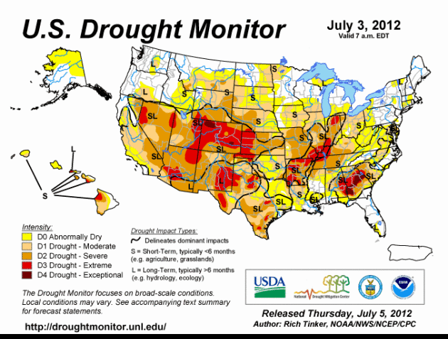
Drought Timeline. NOAA's
U.S. Drought Monitor shows the gradual progression and intensification of the drought covering much of the USA in this
animation.
The statistics are interesting: 70% of the lower 48 states are now
described as "abnormall dry", moderate drought impacting 54% of the
USA (up from 24% at the start of the water year). Severe drought is
impacting over a third of America, up from 15.8% at the start of 2012.
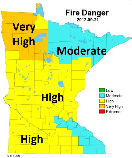
Fire Danger. According to the
Minnesota DNR
the fire risk has been upgraded to "very high" over the Red River
Valley. A high risk exists for most of central and southern Minnesota.
Autumn Forecast: You Might Not Need Heavy Coats For A While.
Call me a contrarian. The venerable Farmer's Almanac is predicting
"warmer and drier" for Minnesota and the Upper Midwest. So is CPC, the
Climate Prediction Center. Based on recent trends and a brewing El Nino
that forecast makes sense, logically. But the atmosphere hasn't been
behaving logically in recent years - I'm pretty sure we'll have a colder
winter than last, but not as severe or snowy as 2010-2011. At this
point even an "average winter" would feel like the real thing. Here's an
excerpt of a story at
The Star Tribune: "
A
warmer-than-normal autumn is likely for Minnesota, and may be followed
by another mild winter, a meteorologist from the National Climate
Prediction Center said Thursday. The agency released its latest
three-month outlook, and seasonal forecaster Huug van den Dool said the
warm regime that's been so pronounced across the hemisphere this year
is likely to continue through October, November and December in
Minnesota and across the United States. January through August of this
year was the warmest such period on record for both the Twin Cities and
Minnesota. As for winter, "I wouldn't go as far as saying it will be as
extreme as last year, but chances are it will be above normal," he
said in a telephone conference with reporters. "That's the long-term
trend." Photo above: AP.
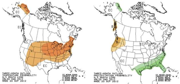
3 Month Guess (Outlook). CPC, NOAA's
Climate Prediction Center,
is forecasting a milder-than-average October thru December for a huge
chunk of the USA, drier than average for the Pacific Northwest, wetter
across the Gulf coast and southeastern USA (which correlates with an El
Nino warming over the central Pacific). Again, buyer beware. Odds favor a
mild bias into at least the first half of winter, based on the trends
of recent winters, but I sure wouldn't bet the farm on this. Call me
perpetually paranoid, but what's happening in the Arctic (record
melting) may have some blow-back across the lower 48. Hope I'm wrong.
Looking Ahead. Everyone wants to know what the
winter will be like. Me too. Can you tell me where the NASDAQ will be in
mid-February? Interest rates in early March? Looking at recent trends
this winter should be milder than average, especially factoring in a
mild to moderate El Nino warming, but that warming is taking place in
the central Pacific, and in previous El Nino's like this the biggest
impacts were over the Pacific Northwest and the southeastern USA, with
little impact (cold or warm) on Minnesota and the Midwest. As I've been
mentioning ad nauseum for days now, the Arctic is a huge wildcard.
Record warming has created a semi-permanent bubble of warm high pressure
at the top of the world, which may displace the cold "polar vortex"
farther south, meaning more bitter swipes extending southward into the
USA. The truth: models have some skill out to 15-20 days. Beyond that,
forget about it. We can use ocean temperatures as cues, but there is
still no reliable way to connect the dots and make a winter prediction
with high confidence. Here is Mark Seeley's take in the latest
installment of
WeatherTalk: "
On
Thursday of this week the NOAA Climate Prediction Center issued new
seasonal climate outlooks. The temperature outlook for Minnesota favors
above normal values over the October-December period. Actually this
trend is seen for about 75 percent of the USA based on dynamical models
and past trends. Little emphasis is placed on El Nino at the moment
because it remains in a neutral state. The precipitation outlooks shows
equal chances for above or below normal values over the
October-December period across most of the USA except the southeastern
and mid-Atlantic states which are expected to see above normal values."
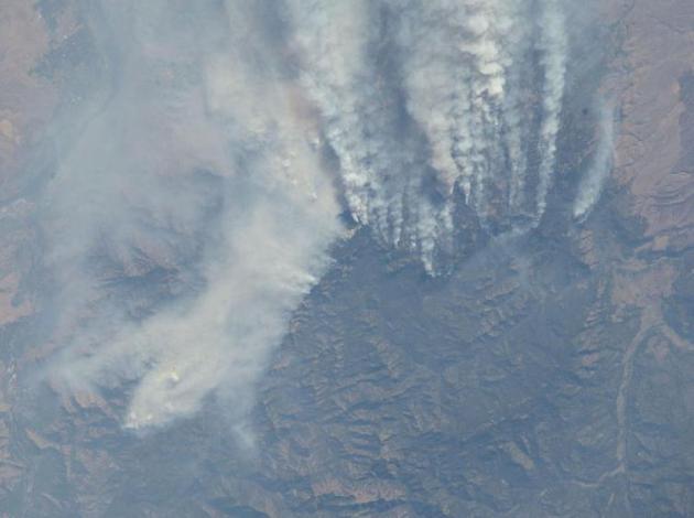
Wildland Fires In Idaho.
NASA has the details: "
One
of the Expedition 33 crew members aboard the International Space
Station, flying at an altitude of approximately 260 statute miles,
recorded this nadir scene of the Mustang Complex wildland fires in
Idaho. Close to 300,000 acres have been burned by the Mustang fires and
hundreds of people have been forced to flee the area."
"Ask Paul". Weather-related questions, comments (and reader explanations!)
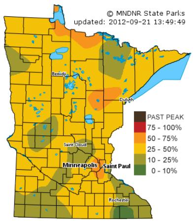
Paul -
I believe the DNR image
of fall colors that you are seeing is a victim of too little data
points. I'm not 100% certain, but I believe the map only uses the
foliage reports out of the state parks. If you look at the state parks
that are used across the metro areas, you can see that Ft. Snelling is
the only park showing 50-75% color (and the only park within the metro
area). Minnesota Valley State Park is showing 25-50%, Afton is showing
10-25%, and Lake Maria is also showing 10-25% color. The result is a
bulls-eye of 'color' over the Twin Cities. Similar to what happens when
an erroneous temperature observation is indicated on a contoured map.
Given
so few data points and the likelihood of data smoothing issues, I'd be
hesitant to make assumptions on the metrowide color being higher than
most. I certainly haven't seen 50% color.
Jon Dejong
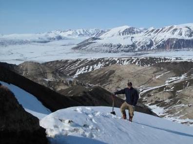
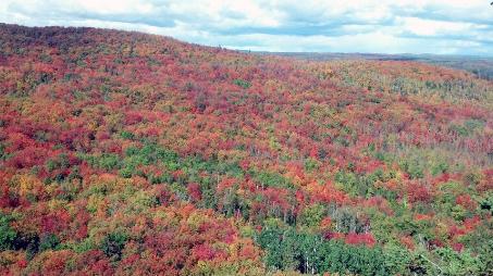
Like An Explosion At A Crayola Crayon Factory. Check out the scenery up at Lutsen: "The view from Moose Mountain. It's a great time to ride the Mountain Tram and enjoy the spectacular foliage!"
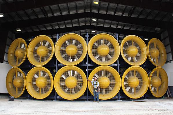
Category 5 Hurricane Simulator Will Blow You Away, Literally. I need one of these for my garage.
Technabob.com has the remarkable details: "
After
living in New Orleans for a number of years of my life, I can speak
from experience that hurricanes can be serious business. So the more we
can learn about how hurricanes and tropical storms work, the more
prepared that we can be for disaster, and the more lives and property
can be spared from nature’s fury. In the interest of learning more
about these storms, one university has built the world’s only category 5
hurricane simulator."
NASA Scientists Used Unmanned Aircraft To Spy On Hurricanes.
Drone technology is here (to stay). Expect to see one over I-94
providing real-time traffic reports within a couple of years. Why not?
Wired Magazine
has the story; here's an excerpt: "Hurricane researchers are gathering
unprecedented data this month by using two NASA Global Hawk unmanned
aircraft. The airplanes were originally developed for the military, but
have been modified to aid in atmospheric research. One of the Global
Hawks was flown to its new base at NASA’s Wallops Island Flight
Facility on Virginia’s Atlantic coast earlier this month and has
already flown several missions over developing tropical storms giving
atmospheric scientists the ability to watch and measure storms for up
to three times as long as they could with manned aircraft, including
NASA’s modified U-2 spyplane. The second Global Hawk is set to depart the
Dryden Flight Research Center in California and join its hangar mate in the next week or so." Photo credit above: NASA.
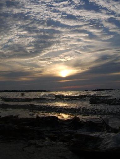
A Reluctant Sunset. Greg Harper captured this photo at De Soto, Florida Friday. Nicely done.
Cloud Appreciation Society. Tsunami-clouds? That's how one local TV station in Birmingham described the formation in this
video clip. The correct answer from the
Cloud Appreciation Society: "
Clouds
that look like a series of breaking waves are known as
‘Kelvin-Helmholtz’ formations. They can appear at the low, middle and
high cloud levels. This video, filmed from Birmingham, Alabama, US,
shows a particularly low example of Kelvin-Helmholtz clouds. So dramatic
were the waves that they were featured in the local news, described by
reporters as the ‘tsunami clouds’. We like dialogue between the
cloudspotting couple. She want’s him to call the TV weather man to ask
what they are. He seems to be too busy using his power tools to put up
some shelves at the same time as he’s filming them…"
Endeavor. It was a majestic (and somewhat sad) sight over L.A. yesterday. Photo credit
here.
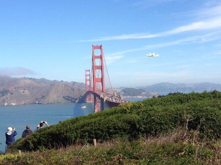
Another Perspective. From
KQED in San Francisco: "
And here's a beautiful shot of the Endeavor soaring over the Golden Gate Bridge!"
The Sites We Love Right Now. How many of the web sites in the "Top 50" do you use on a routine basis? Here's the run-down, according to
Time Magazine Tech: "
Just
a guess: You’re probably already aware that Google, Amazon and Twitter
are worth checking out. So as usual, most of the sites on our 50 Best
Websites list aren’t yet household names. They’re ones we TIME editors
find to be useful, entertaining, innovative or just plain addictive —
and, in some cases, all of the above. Read on, and we’ll tell you about
our favorites in 10 categories. Then let us know about yours in the
comments."
iPhone 5 vs. Galaxy S III. It's getting nasty out
there - have you seen the recent Samsung commercials poking fun at
Apple's new iPhone? The knives are coming out - and I was interested to
see what the tech-heads at
gizmag.com had to say in a head-to-head comparison. Here is an excerpt of their review: "...
In
2012, however, the biggest tech rivalry is the match between the two
biggest players in mobile: Apple and Samsung. This one has gotten
nasty, extending into international courts. Things only get more interesting with the release of Apple's iPhone 5
this week. A great product is much more than the sum of its parts, but –
even in this post-PC era – specs can matter. If one phone has a
quad-core chip with 2GB of RAM, and another a single-core CPU with
128MB of RAM, the first one will be much faster. Likewise, a display
with 320 pixels per inch (ppi) will look much sharper than one with
163ppi. You'd be foolish to worship at the altar of specs, but
technical details can still shed some light on the subject."
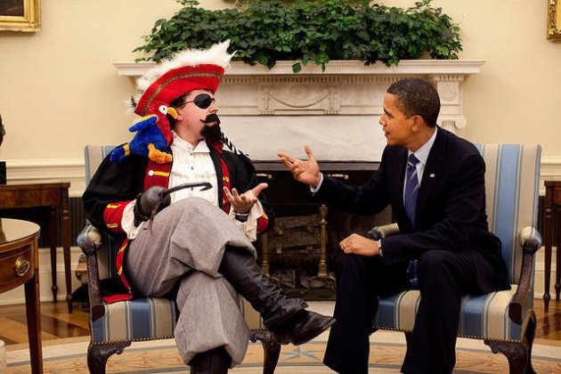
"Fox And Friends" Corrects Claim About Obama's Pirate Meeting (Well Sort Of). Journalism guru
Jim Romenesko has the (crazy details). No, you can't make this stuff up. “
Fox
and Friends” on Thursday used the Obama and pirate shot on the right
to show that the president is more interested in meeting with a pirate
than in conducting foreign policy. The AP’s David Bauder reports: "Over
an on-screen graphic that said “Arrrgh You Kidding?”, Fox ran the
picture Thursday morning with host Brian Kilmeade saying, “The White
House doesn’t have the time to meet with the prime minister of Israel,
but this pirate got a sit-down in the Oval Office yesterday.”
** photo above courtesy of Migizi Gichigumi, who snapped this photo at Washburn, Wisconsin Friday.
Frosty Possibilities
"When in a drought, don't predict rain."
There's some truth to that old proverb. Welcome
to one of the 5 driest Septembers on record.
Prevailing winds are
blowing from the Pacific, a dry pattern for Minnesota. No big southern
storms are brewing, able to take the edge off our deepening drought.
96 percent of Minnesota is abnormally dry;
2/3rds of the state in a moderate drought, including the north metro.
This may be the strongest "signal" of what's to come this winter.
NOAA predicts warmer and drier into December, based largely on "persistence"; acknowledging the current trends.
8 winters since 2000 saw less than 45 inches of
snow in the Twin Cities, 7 of those since 2004. 70+ inches of snow feels
like swimming upstream.
But with historic melting of the Arctic - we are in uncharted waters.
I'm tempted to interview a wooly bear caterpillar.
The official kick-off of fall brings a chilly
breeze and 50s, in spite of patches of blue sky. Frost is likely
tonight, even in outlying suburbs. The "urban heat island" will keep the
downtowns frost-free.
60s return next week, 70s next weekend. Showers brush southern Minnesota next Thursday, enough rain to settle the dust.
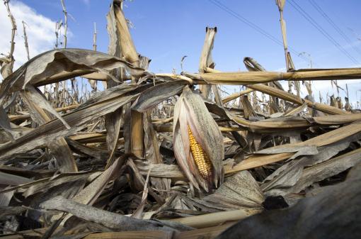
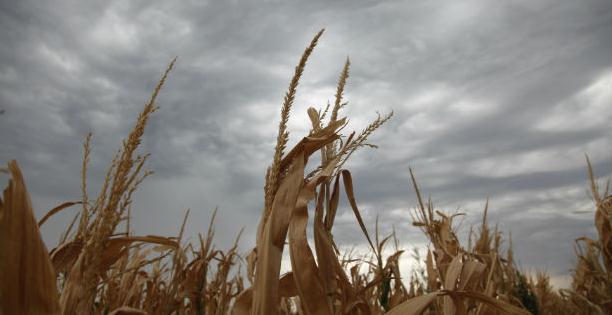
Photo credit above: "In this Sept.
19, 2012, photo corn plants weakened by the drought lie on the ground
after being knocked over by rain in Bennington, Neb. The U.S. Drought
Monitor update released Thursday, Sept. 20, 2012, says recent rainfall
came too late to help already damaged corn crops but may help
still-maturing soybeans. The report says dry conditions continue to ease
in key Midwest states as farmers pick up their corn harvests." (AP Photo/Nati Harnik)
Climate Stories...
Time For The GOP To Get Serious About Climate Change, The New National Security Issue. Here's a snippet from an interesting read at
The Atlantic: "
....This
is not a "soft" issue that should be of concern only to
environmentalists. Climate change can be destabilizing in international
affairs, a fact that the Department of Defense is now trumpeting. As
the 2010 Quadrennial Defense Review Report notes,
climate change contributes to food and water scarcity, provoking or
exacerbating mass migrations, and amping up conflicts over resources.
The report states, "While climate change alone does not cause conflict,
it may act as an accelerant of instability or conflict, placing a
burden to respond on civilian institutions and militaries around the
world."
Photo credit above: "
A badly under-watered Kansas
cornfield awaits rain this past August. An end-of-summer wet spell
helped nurture soybeans, but came too late for the corn crop -- a
development that could raise food prices around the world." (Reuters)
Despite Little Mention Of Climate Change From Candidates, Faith Groups Pledge To Make It A Campaign Issue. Here's an excerpt of a post from
Think Progress: "
This week, the National Climate Summit 2013 Coalition released a petition
calling on both Presidential candidates to address rapidly accelerating
climate change. The statement, written and endorsed by over 1300 faith
leaders, elected officials, civil rights groups, environmental
activists, business representatives, and others, calls on both
Presidential candidates to “act in the best interests of this and all
future generations of American’s now by publicly acknowledging the
climate emergency”; and committing to host a climate summit to craft
actions for national solutions within their first 100 days in office."
What Is The True Social Cost Of Carbon? Here's a clip from an interesting article at
Living Green Magazine: "...
Potential greenhouse gas policy, post-November, remains a murky picture. While candidate Mitt Romney has said he opposes a carbon tax, some of his economic advisers embrace the idea
(subscription) as a means to tackle greenhouse gas emissions,
especially in tight fiscal times. The Washington Post’s Ezra Klein
frames the carbon pricing debate as a bargain between Democrats and Republicans, and a Slate piece offers that carbon taxes are good not only for the environment, but also for the treasury.
Meanwhile, Daveed Gartenstein-Ross argues in The Atlantic that, given
the national-security challenges the issue poses for the U.S., Romney
and the Republican party are “ceding important ground by tolerating and encouraging denialism” of climate change. Ralph Nader says Obama and the Democrats are “running away from the issue” of climate change."
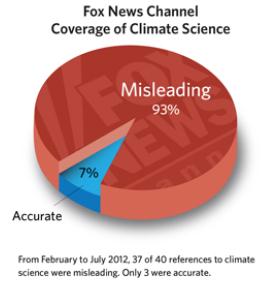
Got Science? Not At News Corporation. Here's an excerpt of a story at
The Union of Concerned Scientists: "
In
2007, News Corporation CEO Rupert Murdoch claimed coverage of climate
change in his media outlets — which include Fox News Channel and the
Wall Street Journal opinion pages — would improve over time. Such
improvement has not been achieved. A 2012 snapshot analysis shows that
recent coverage of climate science in both outlets has been
overwhelmingly misleading. The analysis finds that the misleading
citations include broad dismissals of human-caused climate change,
rejections of climate science as a body of knowledge, and disparaging
comments about individual scientists. Furthermore, much of this
coverage denigrated climate science by either promoting distrust in
scientists and scientific institutions or placing acceptance of climate
change in an ideological, rather than fact-based, context."
PBS Ombud: NewsHour Climate Change Report Worth Criticizing. Here's a clip from
Media Matters for America: "
A PBS NewsHour global warming report that allowed a climate change contrarian to "counterbalance" mainstream scientific opinion is
worth criticizing, according to PBS Ombudsman Michael Getler, who said
he received hundreds of emails and calls about the program. Getler
said he is penning a column on the issue that is likely to be posted
late today or Monday, and hinted it will be critical. "There's just a
lot of...hundreds of emails about it," Getler said when asked why he is
writing about the issue. "Commentary about it all over and it's
interesting." Getler declined to offer specific views on the NewsHour
report, which aired last Monday. But when asked if he has found
elements to criticize, he said: "Oh yeah, of course there's material to
be critical about."
Climate Change Could Awaken Canadian Forests: Study.
The Toronto Sun has the story; here's a clip: "
Ancient
forests in Canada's North could one day bloom again, thanks to climate
change, a new study has found. Bylot Island in Nunavut is home to a
fossilized forest that scientists estimate is between two and three
million years old. Once upon a time, the North's cold and barren
landscape featured a lush forest of oak, pine, spruce and hickory. If
temperatures in the North continue their upward climb, that forest
could return within a century, Alexandre Guertin-Pasquier of the
University of Montreal says. "According to the data model, climate
conditions on Bylot Island will be able to support the kinds of trees
we find in the fossilized forest that currently exist there, such as
willow, pine and spruce. I've also found evidence of a possible growth
of oak and hickory near the study site during this period,"
Guertin-Pasquier said in a press release."
Photo credit above: "
The University of Montreal's Alexandre Guertin-Pasquier at his study site in Nunavut in June 2010." (HANDOUT)
How Green Was My Lawn. What happened to environmentalism? The idealism of the 1960s and 1970s has worn thin. Here is an excerpt of an Op-Ed at
The New York Times that caught my eye: "....
Today,
however, climate change, perhaps the most important environmental
issue of our time, rarely polls among voters’ top five concerns. One
reason may be that its patently global character has enervated support
at environmentalism’s suburban grass roots. But it doesn’t help that
blanket condemnation of suburbs as hopelessly dependent on fossil fuels
comes all too easily."


