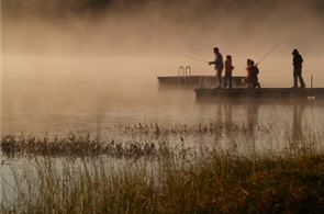
Shelf Cloud. Today's weather blog has a couple of amazing weather photos, including this dramatic "shelf cloud". Details below.
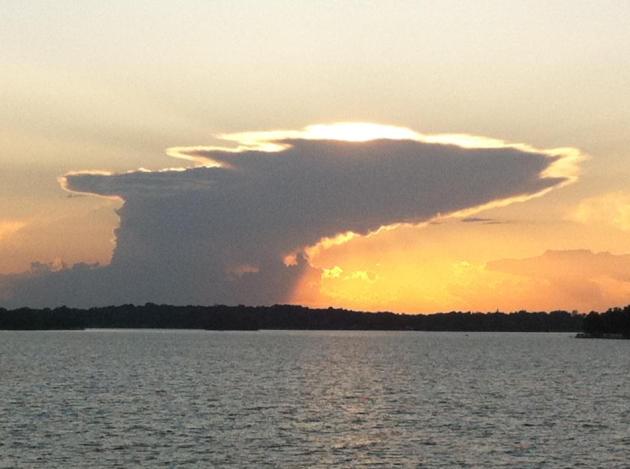
Cumulonimbus. I took this photo around 8:45 pm Monday evening, looking west. A few instability T-showers popped up along the leading edge of a cooler, drier, Canadian front that will drop dew points into the 50s today.
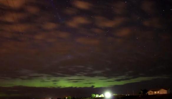
Aurora Possibilities. Recent solar storms have resulted in spectacular sightings of the Aurora Borealis. Details below.
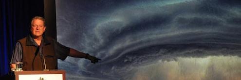
"...A strong, credible body of scientific evidence shows that climate change is occurring, is caused largely by human activities, and poses significant risks for a broad range of human and natural systems…. Some scientific conclusions or theories have been so thoroughly examined and tested, and supported by so many independent observations and results, that their likelihood of subsequently being found to be wrong is vanishingly small. Such conclusions and theories are then regarded as settled facts. This is the case for the conclusions that the Earth system is warming and that much of this warming is very likely due to human activities". (U.S. National Academy of Sciences, 2010)
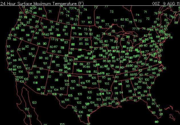
Monday Highs. Data courtesy of the Plymouth State Weather Center.
* Nightime lows have been significantly warmer than average since June 1. Based on NWS "cooling degree data" estimated costs to cool Twin Cities homes and businesses are running 42% higher than average, meaning your electric bill may bring tears to your eyes. Literally.
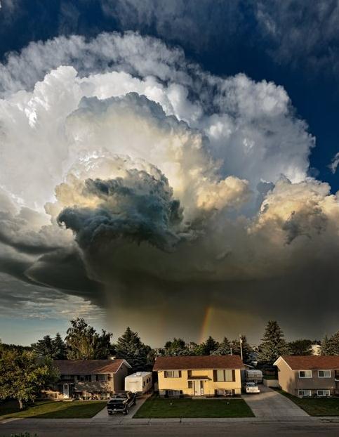
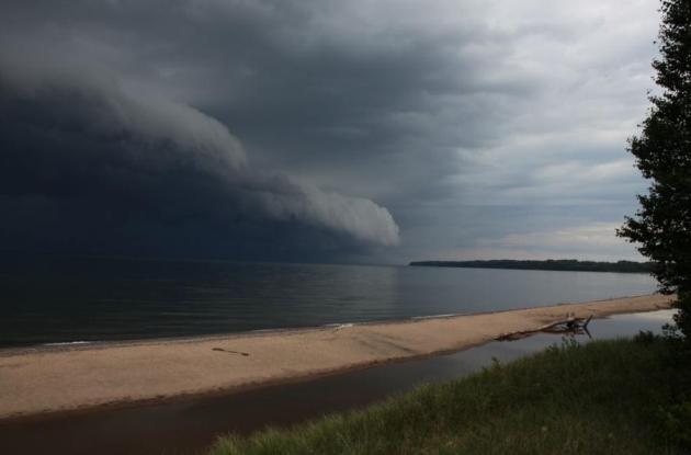
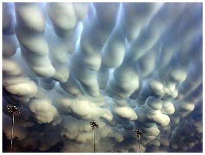
Honorable Mention: "Shelf Cloud". Thanks to Pete Schenck, who lives up on Lake Superior in lovely Herbster, Wisconsin, for sending me a classic example of a shelf cloud, marking the leading edge of rain/hail-cooled exhaust from a strong thunderstorm pushing across the lake, an advancing wedge - lifting warm air aloft, which condenses into a "lip" of clouds, sometimes called a roll cloud or shelf cloud. 5 stars.
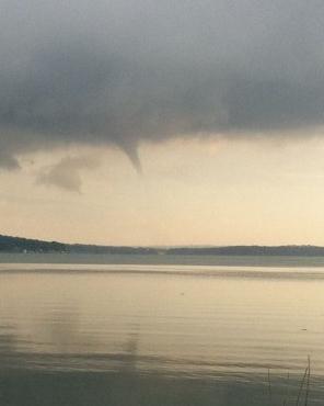
Funnel Cloud Over Madison Lakes. This funnel was spotted over Lake Monona Monday evening - no confirmation of an actual touchdown. The Wisconsin Journal has more details: "The National Weather Service and Dane County 911 Center received reports for about 20 minutes of a funnel cloud over lakes Monona and Mendota on Monday night, but no tornado warning was issued. Ashley Sears, a meteorologist with the National Weather Service in Sullivan, said she couldn't confirm the funnel cloud appearing around 7:20 p.m. because it was weak and there was no visual of it on the radar. "
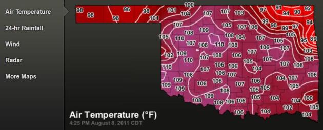
- According to data from the Oklahoma Mesonet, the statewide average temperature
during July came in at 89.1 degrees, more than 7 degrees above normal. The
National Climatic Data Center's statewide average for July stands at 88.9
degrees with data still being collected. Both values shattered the country’s
previous record of 88.1 degrees held by another legendary hot month in
Oklahoma, July 1954. - High temperatures alone were nearly 9 degrees above normal at 102.9 degrees.
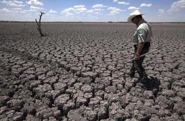
- The extreme heat is being fueled by one of the worst short-term droughts in
state history. The statewide average precipitation total of 16.73 inches since October 1,
2010, is the driest on record at nearly 14 inches below normal. Parts of
southwestern Oklahoma have seen less than 6 inches of rain over that 10-month
period. - The loss of soil moisture and green vegetation has combined with the summer sun
to bake the state unmercifully. - Unfortunately, widespread relief has yet to appear on the horizon. The latest
seasonal drought outlook from the National Weather Service’s Climate Prediction
Center (CPC) calls for drought to persist or intensify in Oklahoma through the
end of October. Farther out, the news is just as troubling. While the La Niña
event faded in late spring, the CPC issued a La Niña watch last week for
possible development once again this winter. The possibility of extending the
current drought further would be very bad news for a state already hit hard by
the heat and lack of rainfall.
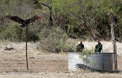
Photo credit above: "Turkey vultures drop in for a drink from one of the very few remaining watering sources on a private ranch that spans over 7,000 acres Saturday Aug. 6, 2011, near San Angelo, Texas. Randy Bolf, a fence contractor and rancher that leases the property for his cattle herd said that all of the rain and run-off watering tanks on the ranch that straddles Tom Green and Coke county have dried up and area wildlife and his cattle rely on the artificial watering sources he maintains on the property. (AP Photo/Tony Gutierrez)"
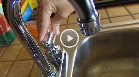
Kaufman County Town Runs Out Of Water. Lakes have turned into puddles, many reservoirs are gone, and towns are starting to run out of water. WFAA-TV has more details: "KEMP — This small town on the shore of Cedar Creek Reservoir ran out of water on Sunday. "No water. No water. Zero water," said Kemp Mayor Donald Kile. "We’re in pretty bad shape, to be honest with you." As the temperature surged into the triple digits for the 37th consecutive day, the mayor decided Sunday to shut down the municipal water system at 4 p.m. Repairs have been made on the system and the city's water levels are slowly returning to normal. Kile said the city expects to have water running freely from faucets by 4 p.m. Tuesday. After that, residents will still need to boil their drinking water for an unknown duration. With no running water, almost every business in Kemp is shutdown. Restaurants, car washes and daycare centers are losing profits. Employees are going without pay."
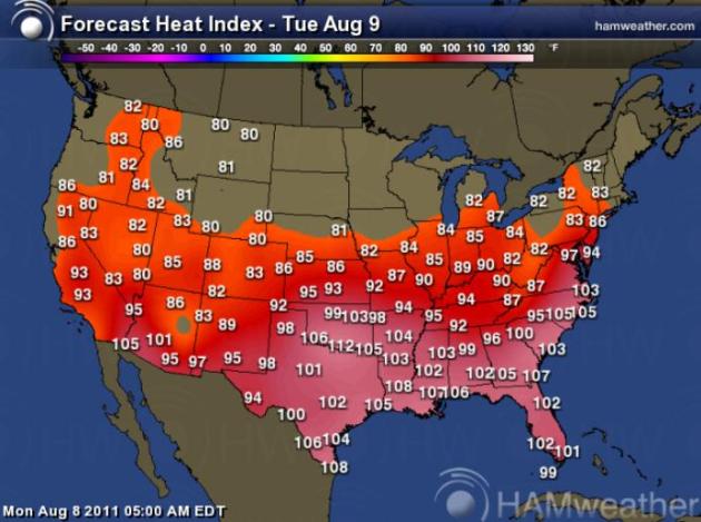
Sizzling South. The predicted heat index reaches 105-110 fom Texas eastward to the Carolinas later today, more heat advisories, more heat watches and excessive heat warnings.
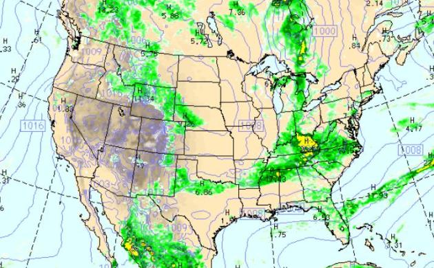
Tuesday Weather Map. The WRF/NAM model map (valid at 7 pm Tuesday) shows a cool front sparking showers and T-storms from Detroit to Louisville - more potentially heavy rain for the Mid South and Carolinas, even a few severe storms across the Virginia. The Upper Midwest enjoys a welcome dip in humidity, more lukewarm sunshine for most of the west.

Roof: If you need to have your roof replaced, specify:
Ring-shank nails: The design of a ring-shank nail resembles a screw, except that the head is flat.
Hurricane clips: The metal bracing connects roofs to walls.
Shingles: Look for materials rated by UL 2218 or FM 4473 as Class 3 or 4, which indicates they have been tested and found to stand up to increasing levels of hail damage. Also make sure the roof cover you choose is rated for the wind speed in your area. For example, shingles meeting the ASTM D 3161 Class F standard are rated for wind speeds up to 110 mph (a Category 2 hurricane), while shingles meeting the ASTM D 7158 Class H standard are rated for wind speeds up to 150 mph (Category 4).
Asphalt shingles are the best value, with hail resistance and wind warranties up to 130 mph. Metal is susceptible to hail damage. Slate is durable but more expensive.
Siding: Cement board is more resistant than vinyl. Cement is not rated by impact and wind like shingles."
* photo above courtesy of NOAA.

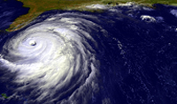
Remnants Of "Emily" Hit Bermuda With 50 mph Winds. Data from NOAA (thanks to James Aman from Earth Networks for forwarding this to me).
TXKF - - gust 51 mph at 10:55 a.m. EDT - - Wade International Airport, Bermuda
BEPB6 - - gust 48 mph at 10:36 a.m. EDT - - NDBC coastal buoy site at Bermuda Esso Pier
* photo above of Tropical Storm Emily striking the Domincan Republic courtesy of the Palm Beach Post.
Preliminary Winter Outlook. Meteorologist Sam Lillo takes a look at the winter-to-come in this Facebook post. According to NOAA there's at least a 50% chance that La Nina will return (probably not as strong as the powerful La Nina that resulted in unusually heavy snow/ice accumulations across so much of America: "The past two boreal winters have featured some extreme conditions around the world. In 2009-2010, the strongest west-based El Nino on record developed in the central equatorial Pacific, forced by three significant westerly wind bursts combined with persistent trade winds over the east Pacific. In concert with a strong easterly QBO, a record breaking low index NAM developed. This pattern contributed to multiple historic snow storms for the eastern U.S. The summer of 2010 followed with a massive transformation of the general circulation. Intensifying trade winds spread cooler waters westward, and a moderate La Nina was rapidly developing. Consequently, tropical forcing made a complete 180. In addition, the QBO westerly shear zone was rapidly descending. Combined with depleted ozone from the strong El Nino, the SAM was persistently in a high index state through the austral winter. Despite the preset conditions of a moderate La Nina and westerly QBO, the winter of 2010-11 once again featured a predominantly low index NAM. And once again, major snow storms pounded the northeast U.S. in December and January. Since January, the La Nina has weakened, in fact at a very fast rate through April and May. Current conditions in the equatorial Pacific may be considered as neutral, though the general circulation still displays characteristics of La Nina. For example, twin upper level cyclones have been persistent over the eastern Pacific. In addition, a solidly negative PDO remains in place with above normal SSTs over the north Pacific and cold SSTs along the North America west coast. The result has been dominating ridging over the North Pacific, a downstream trough over the western U.S., and ridging over the central Plains and Midwest. One big effect of this pattern is the historic heat wave that has impacted the eastern two thirds of the nation this summer. Another persistent feature in the last couple months has been above normal heights over the Arctic. At the same time, heights have been predominantly above normal across the midlatitudes as well, with ridging over the Pacific, Atlantic, northern Europe, and central Russia. So calculations of the AO may return a weak signal, but the NAM is still in a low-index state."

Forecast: Increased Odds Of Seeing The Northern Lights. Check out the YouTube clip taken in the Rapid Cities area. More details: "This is my first attempt of ever doing a aurora borealis time lapse. I used a Canon Rebel XS and took about 110 shots at 30 second exposures, f/3.5, and ISO 1600. I then compressed this into a video clip under 30 seconds long.... the time lapse would be longer, but my camera's battery died right when it was getting good. Unfortunately, there were quite a few clouds around during the time I was taking pictures, so the lights aren't as visible as I would like them to be. However, the clouds do provide a cool effect. Additionally, I was near a road when taking this, and occasionally a car's headlights would brighten up the picture just a bit."
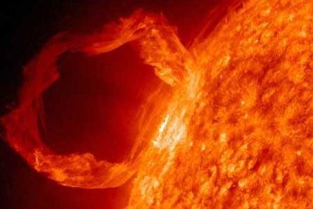
Solar Storms May Disrupt Gadgets. Here are more details on the recent solar storms from Mobiledia:
- U.S. government scientists are cautioning users of telecom and electric equipment to prepare for possible disruptions from a likely magnetic sun storm over the next few days.
- “The magnetic storm that is soon to develop probably will be in the moderate to strong level,” said Joseph Kunches, a space weather scientist at the Space Weather Prediction Center, a division of the U.S. National Oceanic and Atmospheric Administration, or NOAA.
- According to Joseph Kunches, a space weather scientist at the Space Weather Prediction Center, solar storms can affect telecom and GPS satellites, and people as far south as Wisconsin might be able to see the storms’ resulting aurora. Usually the aurora borealis, called the northern lights, are limited to northern latitudes, but the energy of this storm’s colliding energized particles may broaden the display.
- The increasing frequency of solar flares happen when energy stored in twisted magnetic fields, usually above sunspots, is suddenly released. The result is a burst of radiation across the spectrum, from radio waves to x-rays and gamma rays.
- “This will be a two or three out of five on the NOAA Space Weather Scale,” said Kunches.
- There have been three solar explosions from the sun already this week, but the first one passed the earth with little impact. However, the second one, Kunches said, “seems to be stronger.” If that trend continues when the third one passes earth, it could be more disruptive to the Earth’s magnetic field.
- As a practice, the Space Weather Prediction Center alerts power grid managers of upcoming solar events so they can plan for them. The next peak, called a solar maximum, is expected in 2013.
- “We’re coming up to the next solar maximum, so we expect to see more of these storms coming from the sun over the next three to five years,” Tom Bogdan, director of the center, said.
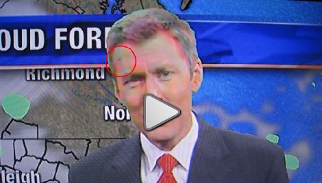
NBC 17's Wes Hohenstein Swallows Bug While Doing The Weather. I hate it when this happens. I distinctly remember a night at KARE-11 when I inhaled a bug - couldn't talk (no great loss). Paul Magers had to recite the 7-Day while I tried to catch my breath. I was outside, in KARE's "Back yard". Poor Wes was indoors, and still managed to find the only bug in the studio. Video clip courtesy of NBC17: "Chief Meteorologist Wes Hohenstein was doing the weather Thursday night on NBC17's 11 p.m. news when all of the sudden a small moth decided it didn't like what Wes had to say."
Climate Stories...
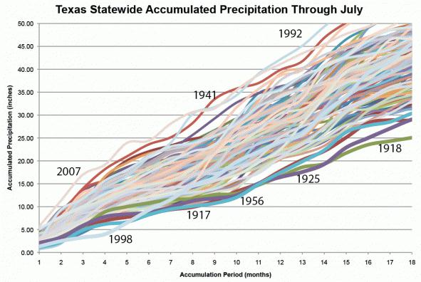
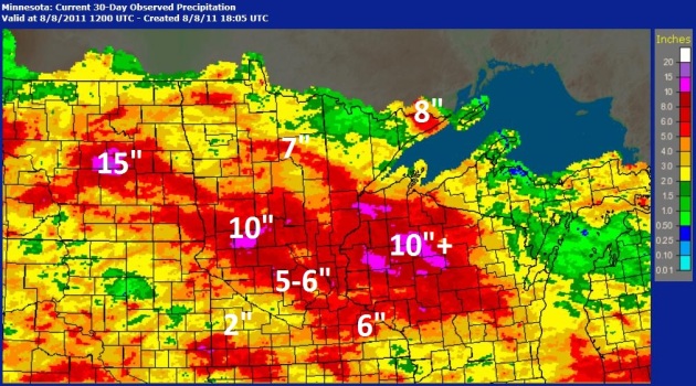
Texas Drought: A Fingerprint. Here's a story from John Nielsen-Gammon at the Houston Chronicle: "Drought has a variety of impacts. Some droughts can hit agriculture hard. Others affect water supplies. Others affect fire danger. Most affect all three, to varying extents. The length and timing of the drought relative to such things as the growing season determines the impact profile. I like to compare drought intensities through a type of diagram I created. (Maybe someone else created it before me, but at least I created it independently.) I call it the Drought Fingerprint Diagram. It’s drawn relative to a particular month of the year. Here, we’ll talk about the July diagram. The x-axis is the number of months of accumulated precipitation. Suppose the precipitation in July 1993 at a particular location was 2.00 inches. Then the one-month data point for 1993 would be at 2.00″. If June 1993 brought 1.50″ of precipitation, the two-month accumulation would be a total of 3.50″, so that’s the value plotted at two months. Another 3.00″ of rain back in May means that the three-month total is 6.50″, and that’s what’s plotted at three months. And so on, as far back as you’d like to go. All the lines slope upward to the right, because each point adds more precipitation from an older month to the current total. Here’s such a diagram (above) for Texas for the period 1898-2010."
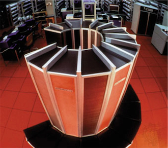
Supercomputers May Help Predict Climate Changes Locally. The Miami Herald reports: "CALVERTON, Md. -- Even a century ago, scientists working out equations on paper understood that gases in the atmosphere absorbed and emitted energy, keeping Earth from being a ball of ice. Today they use supercomputers to make increasingly refined predictions about how the Earth's climate will change. The new efforts take the question from global to local scale. Nations, states and communities have lots of climate-related questions: Should they divert water from one area to another? Build higher sea walls? Store and manage water the way Israel does today? Plan for many more 100-degree days in future summers? "We can't answer those questions with the capabilities we have today. That's why we're using supercomputers to push the limits of what we understand and how well we can predict," said James Kinter. He's a professor in the climate dynamics Ph.D. program at George Mason University in Virginia and the director of the Center for Ocean-Land-Atmosphere Studies. "We know with a high degree of certainty that the planet is warming up, and so just on average every place is going to be warmer," Kinter said. "But nobody lives on the average." (Credit: Cray 1 Supercomputer photo above courtesty of wired.com).
* There are many additional factors that shape computations of the global climate and they require the biggest of today's supercomputers, which calculate algorithms beyond the comprehension of mere mortals or our intuition.
* The science of global warming and climate change is settled in a general sense. However, many details continue to be debated by researchers. There are substantial regional differences in forecasts, and the severity of the consequences for our future climate remain quite uncertain. Here you need to be a much more serious scientist than I am to have an informed view.
While there is much room for debate, challenging the complex science or its conclusions from any one dimension is unacceptable, whether by focusing on one variable, a limited time window, or via anecdotes, or limited personal observation. I, for one, accept the peer-reviewed science but would not be surprised if forecasts shift a great deal in the years ahead. In view of all of the above, policy makers need to be careful."
Don't Confuse Weather With Climate. The Daily Star has a good recap of the difference between "weather" and "climate": "It happens every winter. There will be a massive snowstorm somewhere, and those who deny that man-made climate change is occurring will use the freezing temperatures as proof that the Earth isn't getting any warmer. Just as nonsensical are those who say hot weather in July is a definitive argument that global warming is, indeed, going on. According to preliminary data from the U.S. National Climatic Data Center, 2,712 high-temperature records were tied or broken last month, compared with 1,444 in 2010. At least one weather station in all 50 states set or tied a daily high-temperature record at some point during July. And that proves ... absolutely nothing. Where people on both sides of the argument _particularly the climate-change doubters _ make their mistake is in not knowing the difference between weather and climate. Weather is the condition of the atmosphere over a short period of time. Climate is how the atmosphere "behaves" over relatively long periods of time."
U.C. Berkeley Research Links Tree Die-Offs To Climate Change. The story from The Bay Citizen: "Fungus-related plant diseases are wiping out forests across the world – and new research indicates a similar phenomenon emerged as a result of radical climate change some 250 million years ago. That in turn suggests that scourges such as sudden oak death, Dutch elm disease, and the collapse of eucalyptus stands in Australia could be linked to contemporary climate change. These and other diseases attacking the world’s forests are caused by fungus, or by close relatives of fungus, and some scientists believe the fungi are seizing on tree weakness triggered by climate change and pollution. In a new paper published online Friday by the science journal Geology, UC Berkeley plant biologist Cindy Looy and fellow researchers based in England and the Netherlands argue that soil fungus played a major role in the disappearance of forests millions of years ago."

Did Past Climate Change Encourage Tree-Killing Fungi? LabSpaces.com has the story: "The demise of the world's forests some 250 million years ago likely was accelerated by aggressive tree-killing fungi triggered by global climate change, according to a new study by a University of California, Berkeley, scientist and her Dutch and British colleagues. The researchers do not rule out the possibility that today's changing climate could cause a similar increase in pathogenic soil bacteria that could devastate forests already stressed by a warming climate and pollution. The study, available online today (Aug. 5), will be published in the September 2011 print edition of the journal Geology of the Geological Society of America. The death of the forests – primarily comprised of conifers, which are distant relatives of today's pines and firs – was part of the largest extinction of life on Earth, which occurred when today's continents were part of one supercontinent, Pangaea. The so-called Permian extinction likely was triggered by immense volcanic eruptions in what is now Siberia. The huge amounts of gas and dust thrown into the atmosphere altered global climate, and some 95 percent of marine organisms and 70 percent of land organisms eventually went extinct."

Global Warming Is A Litmus Test For U.S. Republicans. The U.K. Guardian has the story - here's an excerpt: "Mitt Romney, arguably the leading Republican candidate for president of the United States in the 2012 election, recently significantly diminished his prospects for obtaining the support he needs from the right wing of his party. How did he do this? He simply declared that he believes the Earth is warming, and that human activities are responsible. To most scientists, such a statement would be considered fairly innocuous, and an accurate assessment of current understanding. But to a large fraction of the US Republican party, this is a completely unacceptable position - ranking alongside gay marriage, gun control and abortion rights. Anthropogenic climate change has become a litmus test for Republicans in the United States. If you want to appeal to the hard core of the party - those whom you need in order to obtain the party's nomination - you simply can not acknowledge what almost every national science academy and scientific organisation has accepted for many years. In fact, many other prominent Republicans, sensing the winds of retribution, have already back-tracked on whatever previous statements they might have made, if they contained even a whiff of climate reality. Given the importance of getting the United States on board to obtain a comprehensive international agreement on controlling greenhouse gases, this dismissal of scientific evidence about global warming is both sad and alarming."