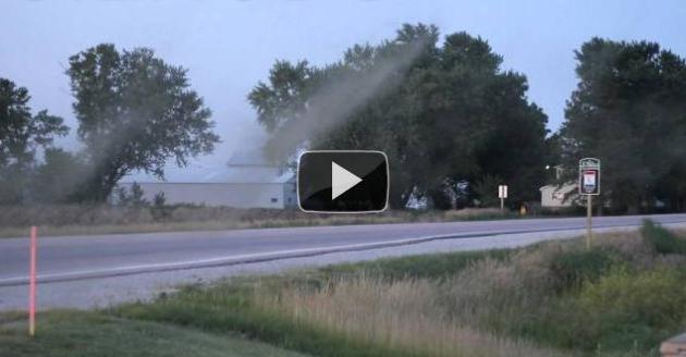
10 minutes warning for the Indiana State Fair Saturday evening. Severe storm warnings were issued by the local NWS office in Indianapolis at 8:39 pm. The storm's "gust front" arrived at 8:49 pm, winds gusting as high as 60-70 mph, close to hurricane force. (photo credit: cleveland.com).
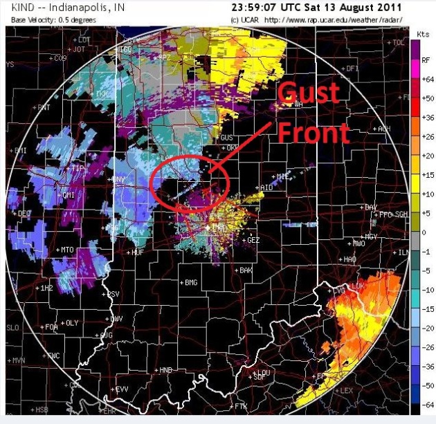
Anatomy Of A Killer Gust Front. AccuWeather has an interesting forum that talks about the conditions leading up to the severe T-storm downdraft that whipped up estimated straight-line winds of 60-70 mph. The bottom line: there WAS warning, but somehow the most essential information never made it to the people most vulnerable in time to prevent a tragedy. Another major factor: building codes for concert stages (I can't believe they're designed to withstand 70 mph gusts). Which brings up a serious liability concern: will this impact future concerts? Will codes be strengthened to insure that a similar stage set can't come toppling down in strong winds? Lot's of questions. Here is an excerpt of a post at the AccuWeather forum that caught my eye: "Looking at the archived velocity radar (above), you can clearly see the OFB/gust front start to show up at 23:59:07. Between 00:30 and 00:35, a storm exploded off the original OFB on the NW side of Indy via reflectivity scans. A Severe Thunderstorm Warning was issued at 00:39 with 16 minutes lead time. Sadly, the state police and fair grounds director were looking at a radar app for their PHONE! They suggested that ppl start evacuating the area and the promoter "warned" ppl that they MIGHT be evacuated...a few minutes later, the stage collapsed."
* radar image above courtesy of AccuWeather.

"Gustnado" May Have Caused Indiana Stage Collapse. Heather Buchman and Henry Margusity from AccuWeather speculate that a gustnado (a brief, mini-tornado-like surge of wind that sometimes forms along the leading edge of a severe gust front) may have helped to focus damage in the vicinity of the main stage: "After studying video footage and radar images from Saturday's deadly stage collapse at the Indiana State Fair, AccuWeather.com Senior Meteorologist Henry Margusity suspects that a gustnado was a cause of the collapse. "In the video, it appears that a possible gustnado traveled from left to right across the stage area," Margusity said. "The video shows a swirl of dust coming across the stage, and it's only when the swirl hits the stage that the stage actually collapses." The National Weather Service defines a gustnado as a short-lived, ground-based, shallow vortex that develops along a gust front associated with either thunderstorms or showers. More information is provided at the bottom of this page. Margusity also pointed out from the video more clues from a flag waving in the background. "Typically, a flag that size needs winds of about 46 mph to wave around like that," Margusity explained. "Given that the flag pole was moving as well, winds were probably near 50 mph."
* photo credit above: "This screen shot was taken from the YouTube video of the stage collapse, posted by JSilas7."
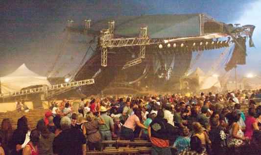
Clues Sought In Collapse Of Stage At Indiana State Fair. The New York Times has more details about the severe "gust front" that brought down a stage, with tragic consequences: "Just hours after lights and rigging on a concert stage at the state fair in Indianapolis toppled into a crowd, killing five people and injuring at least four dozen more, Indiana officials opened an investigation on Sunday to learn the cause of the calamity and what role the weather, including a wind gust that topped 60 miles per hour, may have played. Gov. Mitchell E. Daniels Jr. called the accident “freakish,” and officials linked it to a wind gust that passed through the area moments before the stage collapsed on Saturday night. Along with checking for any evidence of structural problems with the stage setup, investigators will also be looking into whether fair officials acted swiftly enough or paid appropriate heed to a severe thunderstorm watch that was issued nearly three hours before the scheduled concert." (photo: Getty Images).
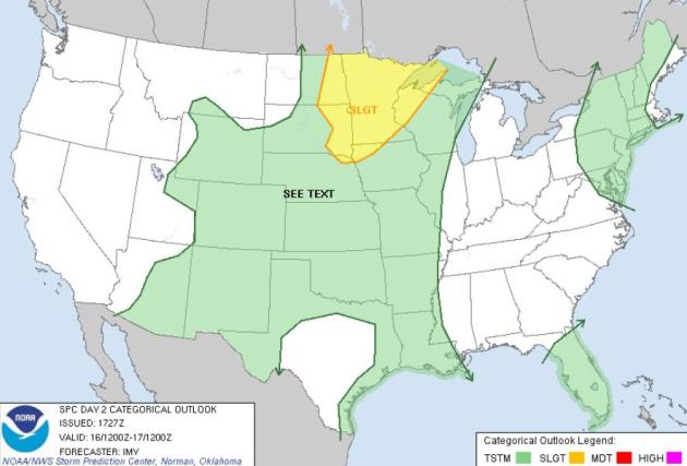
Tuesday Severe Threat. Here we go again - another day, another risk of severe storms over the Upper Midwest, especially Minnesota. Watches and warnings are likely later today. Map courtesy of SPC.

15 days/row above 100 at Houston, a new record. Previous record was 14 days/row above 100 in 1980.
90.6 F. average temperature so far in August in the Houston area, 3 degrees hotter than the previous all-time record.
* photo credit above: Jackson Myers @ flickr.com.
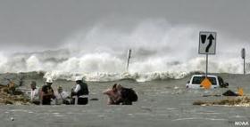
"...But surge is the most devastating element of a hurricane, killing more people than all other hurricane-related threats (freshwater flooding, winds and tornadoes) combined since 1900, according to the National Hurricane Center website." - USA Today article on a new scale to measure and rate hurricanes.
"...The Intergovernmental Panel on Climate Change (IPCC) Fourth Assessment Report, released in 2007, forecasts an ice-free Arctic summer by the year 2100. However, the Arctic sea ice may be thinning four times faster than predicted, according to Pierre Rampal and his research team of MIT'S Department of Earth, Atmosphere, and Planetary Sciences (EAPS)." - article below on accelerating ice melt in the Arctic from International Business Times.
"...There's no doubt about it - sea ice is going away," she said. "What we found was that about half of that trend is related to the increasing greenhouse gases." The other half of the sea-ice loss, as observed over the late 20th century, was "just related to variability in the system." - Miami Herald story below.
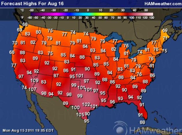
Tuesday Highs. 100-degree heat persists over the Southern Plains and portions of the southwestern USA, relatively comfortable 70s over the northern tier states, partial relief from the humidity for the southeast. Map courtesy of Ham Weather.
...RECORD DAILY MAXIMUM RAINFALL SET AT LAGUARDIA NY... A RECORD DAILY MAXIMUM RAINFALL OF 6.60 INCHES WAS SET AT LAGUARDIANY YESTERDAY. THIS BREAKS THE OLD RECORD OF 3.51 INCHES SET IN 2005.THIS IS ALSO THE SECOND HIGHEST ALL TIME DAILY RAINFALL FORLAGUARDIA...JUST SHY OF THE ALL TIME DAILY RECORD OF 6.69 INCHES SETON APRIL 15 2007....RECORD DAILY MAXIMUM RAINFALL SET AT CENTRAL PARK NY... A RECORD RAINFALL OF 5.81 INCHES WAS SET AT CENTRAL PARK NYYESTERDAY. THIS BREAKS THE OLD RECORD OF 3.10 INCHES SET IN 2005.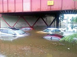
New York Metro Area: Nearly Twice The Normal Monthly Rainfall In One Day. AccuWeather has more details: "Extreme rain resulted in flooding across the Northeast on Sunday. Records were smashed, including an all-time record rainfall at the JFK International Airport in NYC. The New York City JFK Airport set the wettest day on record with 7.80 inches on Sunday. This smashed the all-time daily rainfall record of 6.27 inches on June 30, 1984. The old daily rainfall record was 0.96 of an inch of rain set in 2008. The normal rainfall for the month of August at the JFK Airport is 3.68 inches, so nearly twice the normal monthly rainfall was delivered in one day."
* CBS New York has more on Sunday's record rainfall amounts here.
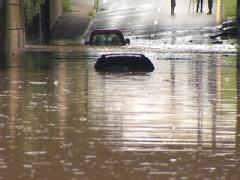
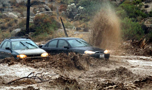
Flooding Leads To Evacuations, Submerged Vehicles, Delayed Train Schedules. More on the record flooding in the northeast from the Baltimore Sun: "Emergency workers responded Monday to several reports of flooded streets and homes after early morning rainstorms, including residences in Baltimore's Cherry Hill neighborhood, where residents had to be evacuated due to water flowing into basements, and the Brooklyn section of Anne Arundel County. Meanwhile, the National Weather Service issued a flash flood warning for the city and south central Baltimore County until 4:15 p.m. Monday. In addition, some Amtrak and MARC train service was delayed between Washington and Baltimore. Shortly after noon, the Maryland Mass Transit Administration announced that MARC Penn Line service between Washington and Baltimore was temporarily suspended due to "high water" over the tracks. Train 520, which had a 12:20 departure time in Washington, was delayed leaving the station, but service resumed before 1 p.m. The MTA advised passengers to expect delays to all MARC trains between Baltimore and Washington." (photo courtesy of WBAL-TV).
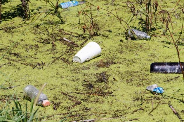
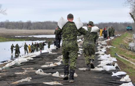
Smelly Surprises Lurk Beneath Missouri River Flood. Here's an update from the AP: "OMAHA, Neb. (AP) — When the Missouri River's floodwaters recede this fall, piles of debris, silt and some smelly surprises will be revealed. It's hard to say exactly what's hiding under the waters, but experts said it is certain that this year's epic flood will leave behind a mammoth mess once the water returns to within the Missouri River's banks. "It's a very unpleasant chore for people trying to clean this up," said John Remus, who oversees hydrologic engineering for the Army Corps of Engineers' Omaha office. The corps has been releasing massive amounts of water from the dams along the Missouri River all summer to deal with above-average Rocky Mountain snowpack and unexpectedly heavy spring rains. The huge amount of water flowing down the river caused flooding all along the Missouri that began in June and will continue into fall. Many of the hundreds of thousands of acres the river flooded in Iowa, Nebraska and Missouri this year were farmland, so the mess is certain to include agricultural debris like crops, fuel tanks, branches and miscellaneous equipment. "We know that there's going to be damage up and down the river, but the degree of damage is likely to vary considerably," said David Haldeman, a division administrator with the Nebraska Department of Environmental Equality."

Houston: A "Ridiculously Warm" August Continues. The Houston Chronicle's Eric Berger explains the sweltering pattern gripping Houston and much of Texas: "This is getting ridiculous. Of course Houston has continued its 100-degree-day streak and could break the record set in 1980 today. But that’s not the worst of it. The entire summer has, overall, been brutal. First came June, with an average temperature of 86.2 degrees that ranked as the warmest on record in Houston according to the National Weather Service. July came in at 87.1 degrees, third warmest on record for Houston. But August has been different altogether. This month’s average temperature is 90.6 degrees. Granted the month is only half over, but that is truly ridiculous. The warmest August on record, which occurred just last year, was 87.7 degrees. So this August has been very nearly 3 degrees warmer than any August on record. Let’s put this another way. The typical August in Houston has an average temperature of 85.0 degrees. The warmest previous August, last year, was less than 3 degrees warmer than that. Then there’s this August, which so far is an additional 3 degrees above the warmest ever August. Someone whose better at math than me could probably tell me how many standard deviations outside of the norm 90.6 degrees would be after 120 years of records."
Extreme Prairie Weather Focus Of University Study. The story from the Montreal Gazette: "Every time there is a weather disaster, the media tends to attribute it to global warming, but scientists are not that certain," he said. "We are going to look at the connection with global warming and whether it's making the extremes more severe and more often." The southern Prairies is the ideal place for research with the potentially disastrous climate. "The most costly disasters in Canadian history have always occurred in the Prairies," said Sauchyn. "That's partly because we have one of the most extreme climates in the world. "Very few places on earth have the swings that we do."


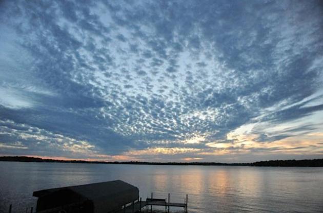
"Altocumulus". Mid-level clouds approximately 10,000 feet above the ground were evidence of instability aloft, an irritable atmosphere that may spark a few strong/severe storms by evening.
Monsoon Season
No, the rain is not falling as gently as it did for your grandparents. Recent research suggests a 24% nationwide increase in "extreme precipitation events", both rain and snow. Data collected since 1948 shows a 61% spike in flash flooding across New England. Tell that to residents of the New York City area (where some 8"+ rainfall amounts were reported Sunday; more than 2 month's worth of rain in less than 24 hours - a tropical storm's worth of rain!) Monday morning NWS Doppler out of Grand Forks displayed some 8-10" rainfall amounts over southeastern North Dakota. Every other day we see stark evidence of this new (increasingly extreme) weather regime.
JFK airport in New York was drenched with 7.8" rain Sunday, setting a new all-time record. That's more than 2 month's worth of rain falling in less than 24 hours. Why? A warmer atmosphere holds more water vapor, more fuel for extreme local rains. Tell that to residents living along the Missouri River, in the midst of a 6-month flood. All this while Houston bakes thru the 16th day/row above 100; a new record. Crazy times in the weather department. Every day I see something that makes me do a triple-take.
* photo above courtesy of the Weather Underground.
Climate Stories...
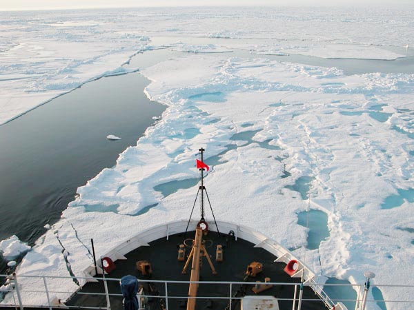
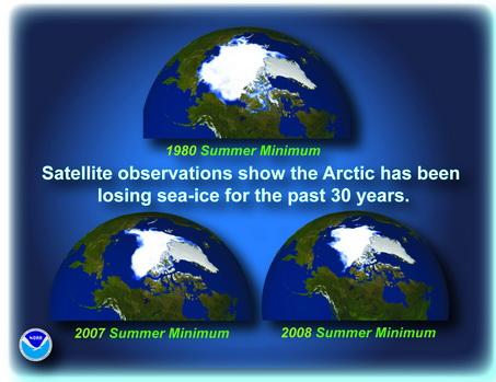
U.N. Climate Report Fails To Capture Arctic Ice Thinning Reality: MIT. The International Business Times has a story about the rate of ice melt at the top of the word, exceeding earlier expectations and predictions by a factor of 4: "The United Nations' most recent global climate report "fails to capture trends in Arctic sea-ice thinning and drift, and in some cases substantially underestimates these trends," says a new research from MIT. The Intergovernmental Panel on Climate Change (IPCC) Fourth Assessment Report, released in 2007, forecasts an ice-free Arctic summer by the year 2100. However, the Arctic sea ice may be thinning four times faster than predicted, according to Pierre Rampal and his research team of MIT'S Department of Earth, Atmosphere, and Planetary Sciences (EAPS)." (photo above courtesy of NOAA).
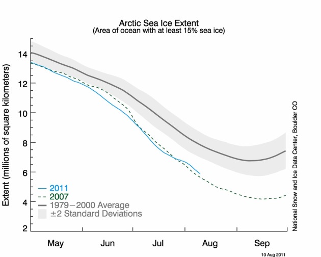
Global Warming: Arctic Sea Ice Hit Record Low In July 2011. The Summit County Citizens Voice has the story: "SUMMIT COUNTY — Arctic sea ice extent reached a record low level in July before recovering at the end of the month. As of July 31, the sea ice extent was at 2.62 million square miles. During the northern hemisphere summer, the ice shrinks through September, then starts to expand again through the winter. Accurate sea ice extent measurements date back to 1979, when satellites first started delivering reliable data and photographic images. This July, the sea ice extent was 81,000 square miles less than the previous low, set in 2007, and 842,000 square miles less than the average for 1979 to 2000, according to the monthly update from the National Snow and Ice Data Center’s Arctic Sea Ice News & Analysis web page. Based on the data gathered since 1979, Arctic sea ice is disappearing at a rate of about 6.8 percent each decade. Signalling the trend of vanishing sea ice, new data shows that more of the Arctic’s store of old and thick ice is melting. The ice melted quickly in early July, but the melting slowed down the second half of the month as a high pressure system over the Beaufort Sea, north of Alaska, broke down, bringing stormier and cooler weather to the region. The Arctic ice researchers say the weather change probably pushed the ice apart, forming a thinner but more extensive ice cover."
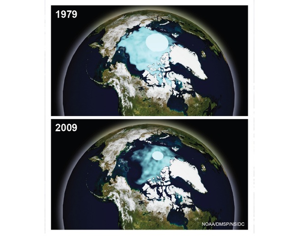
One of the consequences of rapidly melting arctic ice:

Russia's Arctic "Sea Grab". The Christian Science Monitor explains how Russia is taking full advantage of dramatic changes in the Arctic: "In a multinational race to seize the potential riches of the formerly icebound Arctic, being laid bare by global warming, Russia is the early favorite. Within the next year, the Kremlin is expected to make its claim to the United Nations in a bold move to annex about 380,000 square miles of the internationally owned Arctic to Russian control. At stake is an estimated one-quarter of all the world's untapped hydrocarbon reserves, abundant fisheries, and a freshly opened route that will cut nearly a third off the shipping time from Asia to Europe. The global Arctic scramble kicked off in 2007 when Russian explorer Artur Chilingarov planted his country's flag beneath the North Pole. "The Arctic is Russian," he said. "Now we must prove the North Pole is an extension of the Russian landmass."
New Study Blames Human Beings For Half Of Arctic Ice Melt. The Miami Herald has the story: "ANCHORAGE — About half the recent record loss of Arctic sea ice can be blamed on global warming caused by human activity, according to a new study by scientists from the nation's leading climate research center. The peer-reviewed study, funded by the National Science Foundation is the first to attribute a specific proportion of the ice melt to greenhouse gases and particulates from pollution. The study used supercomputers and one of the world's most sophisticated climate models to reach its conclusions, said lead author Jennifer Kay, a staff scientist at the National Center for Atmospheric Research in Boulder, Colo. The paper was published last week in the scientific journal Geophysical Research Letters. Kay said her study was an attempt to learn how much Arctic Ocean melting can be attributed to "natural variability" - complex changes wrought by nonhuman forces - and how much has been caused by greenhouse gases such as carbon dioxide and by atmospheric particulates. In doing so, she was also able to look ahead to future annual and decade-long fluctuations. She and the other authors said conditions will become more volatile from year to year. That means there will be years and perhaps decades when the ice pack expands. But the trend is in the other direction." (image above courtesy of NOAA).

A Darker Shade of Green. Here's a fascinating article that ran in Sunday's New York Times Magazine: "Sitting in a Panera in Boston’s financial district in early July with Jeremy Grantham, I suddenly found myself considering how I might safeguard my children’s and notional grandchildren’s future by somehow engineering the U.S. annexation of Morocco. Grantham, the founder and chief strategist of the asset-management firm GMO, was reading aloud from a rough draft of his next quarterly letter to investors, in which he ranks some long-term crises of resource limitation along a scale from “merely serious” to “dangerous.” Energy “will give us serious and sustained problems” over the next 50 years as we make the transition from hydrocarbons — oil, coal, gas — to solar, wind, nuclear and other sources, but we’ll muddle through to a solution to Peak Oil and related challenges. Peak Everything Else will prove more intractable for humanity. Metals, for instance, “are entropy at work . . . from wonderful metal ores to scattered waste,” and scarcity and higher prices “will slowly increase forever,” but if we scrimp and recycle, we can make do for another century before tight constraint kicks in."
Global Warming Affecting Life on Long Island. Here's an article from Long Island's Newsday (subscription required to read the full text of the article): "Climate change is altering Long Island and the results are all around us -- from longer growing seasons and earlier blooms to an influx of birds extending their range northward. Temperatures measured at Islip are on average 1.5 degrees higher than they were 30 years ago. Over 40 years, the waters of eastern Long Island Sound have warmed 1.8 degrees, a trend scientists suspect will eventually..."

Climate Change Linked To Longer Ragweed Season. The details from mycentraljersey.com: "NEW BRUNSWICK — Ragweed season once again has begun early in the metropolitan area, according to Dr. Leonard Bielory, a specialist in allergy and immunology who made the first sighting. Bielory, with the Department of Environmental Sciences at the Rutgers School of Environmental and Biological Sciences, is certified by the American Academy of Allergy, Asthma and Immunology National Allergy Bureau as a pollen counting station. “The earlier sighting is consistent with our findings that climate change may be affecting pollen release and earlier development of allergies,” Bielory said. Three out of four Americans who have allergies are allergic to ragweed pollen, which causes hay fever. Allergies associated with ragweed pollen costs about $21 billion a year in the U.S." (photo above courtesy of Discovery News).