 "...One of my greatest nightmares was having a major hurricane go up the whole Northeast Coast," Max Mayfield, the center's retired director, told The Associated Press. He said the damage will probably climb into billions of dollars: "This is going to have an impact on the United States economy
." - from a Huffington Post article on Hurricane Irene below.
"...Two factors that contribute to more intense tropical cyclones-ocean heat content and water vapor-have both increased over the past several decades--ocean heat content and water vapor--have both increased over the past several decades. This is primarily due to human activities such as the burning of fossil fuels and the clearing of forests, which have significantly elevated carbon dioxide (CO2) levels in the atmosphere." - article below on a possible link between climate change and hurricane intensity.
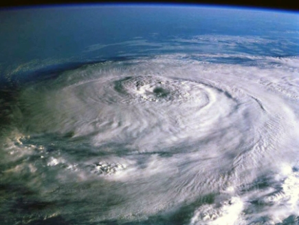
 NOT A Worst-Case Scenario For New York City
. I've been hearing some reports of a 10 foot storm surge in New York Harbor. Not sure where that's coming from - most of the models take Irene east of Manhattan, in which case the storm surge would be in the 1-3 foot range, maybe higher near Union, New Jersey - but hardly the "Storm of the Century". NOAA's latest surge prediction is above.
Hurricane Irene Is "Extremely Dangerous", President Obama Warns. Here's an update from
CTV.com: "
As Hurricane Irene made its way across the Atlantic on Friday, U.S. President Barack Obama warned residents in at-risk areas to take precautions or evacuate their homes in advance of "what's likely to be an extremely dangerous and costly storm." Irene was downgraded slightly from a Category 3 to a less-severe Category 2 storm, but is likely to strengthen by the time it reaches the mainland. On Friday the slow-moving storm had maximum sustained winds of 175 kilometres per hour. "I cannot stress this highly enough: if you are in the projected path of this hurricane you need to take precautions now," Obama said, speaking in Martha's Vineyard where he is on vacation with his family. "Don't wait, don't delay. We all hope for the best but we have to be prepared for the worst, all of us have to take this storm seriously."
The Northeast Is Cancelled Until Further Notice. Here's a summary of all the closures to transit (and entertainment), courtesy of
ABC News: "
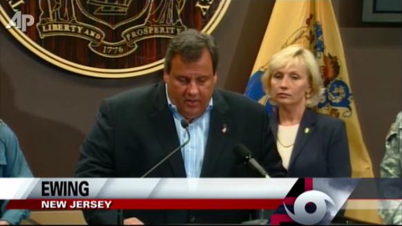
Hurricane Irene has blown away the weekend plans of millions, from airports to cruise ships to island and beach holidays, as travelers rely on storm trackers and households prepare for strong winds, rain and possible flooding. New York Gov. Andrew Cuomo announced New York City will shut down subways, other mass transit starting noon Saturday. "We are fully committed and we are preparing for the worst," Gov. Cuomo said in a statement. The 11 casinos in Atlantic City, N.J., are expected to close for the weekend, though a formal decision won't be announced until casino executives meet at 2 p.m. Friday with local and state emergency management officials. New Jersey Gov. Chris Christie announced beginning at 6 p.m. Friday, eastbound traffic into Atlantic City will close to help evacuate residents in shore areas. He said all gaming in the city will stop at noon Saturday."
 A New York Hurricane Could Be A Multi-Billion Dollar Disaster.
 Right now it appears that Irene will track JUST EAST of New York City, potentially sparing Manhattan and the other boroughs of New York from the worst of the storm surge - a much greater threat along the southern coastline of Long Island. Here's a blog post from the
New York Times: "Time to think about the unthinkable. What if a major hurricane were to pass close to New York City, as several forecasting models now suggest that Hurricane Irene might? Apart from the inevitable loss of life in the most densely populated part of the country, history suggests that the economic damage could run into the tens of billions of dollars, depending on the severity of the storm and how close it comes to the city. Unlikely but theoretically plausible scenarios could have the damage entering the realm of the
costliest natural disasters of all time, and perhaps being large enough to have a materially negative effect on the nation’s gross domestic product. Tropical cyclones in and around New York City and the Northeastern United States are fairly rare but not unprecedented. Using a relatively conservative set of criteria, I have identified 20 storms since 1900 that have made landfall north of the
Mason-Dixon line with tropical-storm force winds (at least 39 miles per hour) or higher, 12 of which made direct hits on either Long Island or New Jersey.
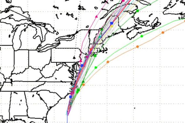 Latest Track Projections.
 After striking the Outer Banks of North Carolina Irene will weaken slightly (probably to Category 1 strength), and then hug the Delaware/New Jersey coast, probably tracking (just) east of New York City. Irene will probably maintain hurricane status as it hits southern New England during the day Sunday.
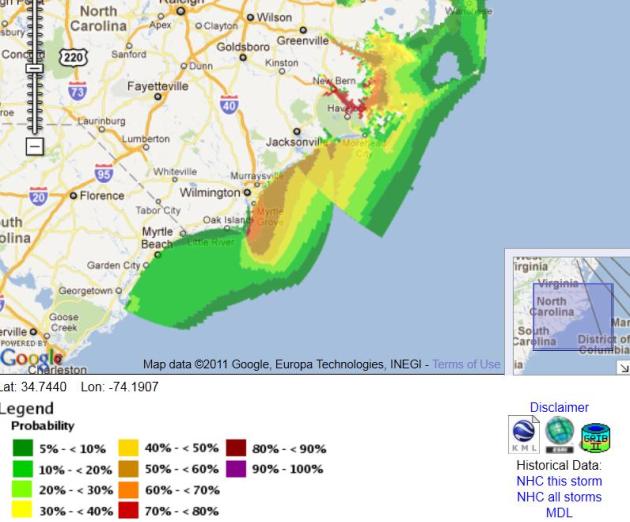 Probability Of A 4 Foot Storm Surge.
 The greatest risk of a damaging storm surge is forecast to be in the New Bern, North Carolina area, and near Wilmington, NC. Data courtesy of NHC.
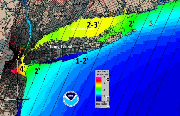
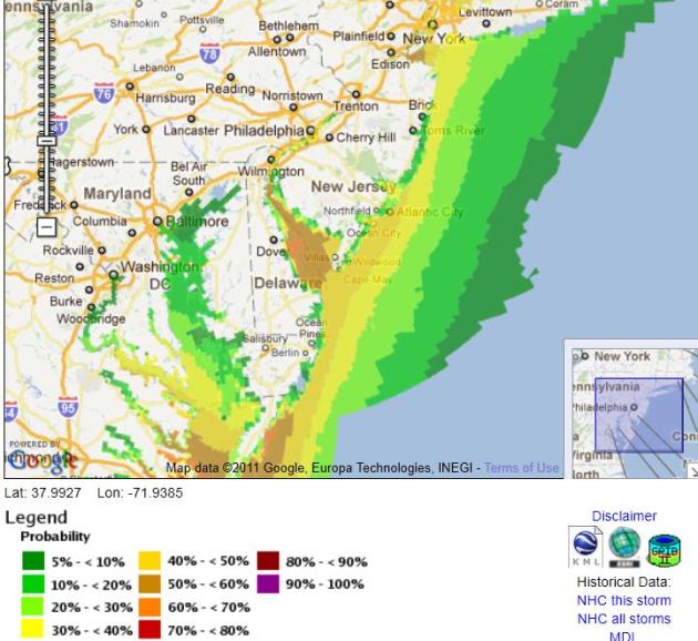 Probability Of A Two Foot Storm Surge?
 The Tidewater region of the Chesapeake Bay is vulnerable (Norfolk, Hampton, Newport News), and a significant storm surge may roll into the Dover, Delaware area and New York Harbor may see a 2-4 foot surge. Raw data is
here, courtesy of NHC.
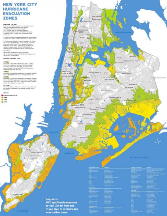
Most Vulnerable Regions Of New York City. The yellow/orange-shaded areas are most vulnerable to a hurricane's storm surge, including Lower Manhattan and much of Brooklyn. JFK and LaGuardia airports could also be closed, both situated very close to sea level. Click
here to see the map for yourself, courtesy of the City of New York.
Total Number of Hurricane Strikes Since 1900. This is broken down by county, showing a total of 20-25 separate hurricane strikes for the Outer Banks of North Carolina since 1900, fewer than 3 for New York City, but 7-9 different hurricanes for Long Island and Cape Cod in the last 111 years. Source:
NOAA's NHC.
Hurricane Irene: Governors Declare State of Emergency. More hurricane information from
The Huffington Post: "
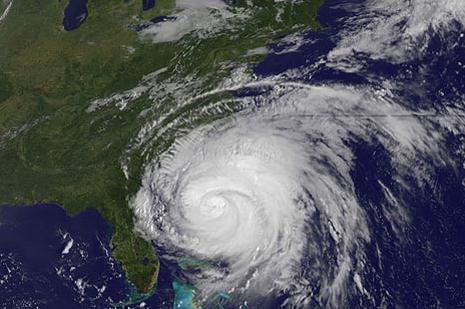
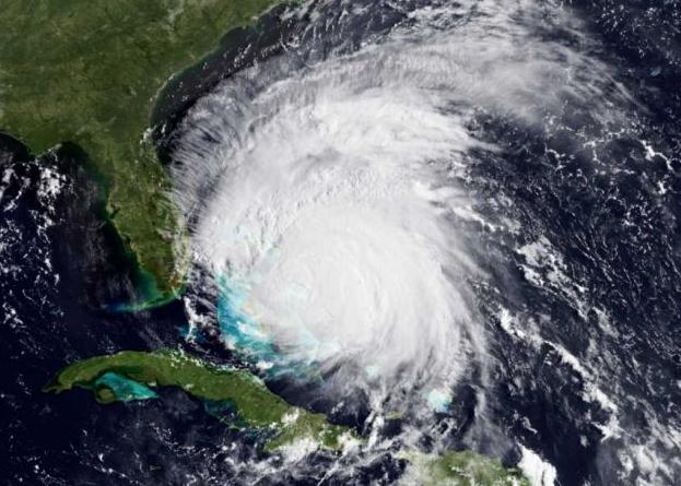
BUXTON, N.C. -- A monstrous Hurricane Irene tightened its aim on the Eastern Seaboard on Thursday, threatening 65 million people along a shore-hugging path from North Carolina to New England. One of the nation's top experts called it his "nightmare" scenario. The Category 3 storm with winds of 115 mph – the threshold for a major hurricane – would be the strongest to strike the East Coast in seven years, and people were already getting out of the way. Tens of thousands fled North Carolina beach towns, farmers pulled up their crops, and the Navy ordered ships to sea so they could endure the punishing wind and waves in open water. All eyes were on Irene's projected path, which showed it bringing misery to every city along the I-95 corridor, including Washington, New York and Boston. The former chief of the National Hurricane Center called it one of his three worst possible situations. "One of my greatest nightmares was having a major hurricane go up the whole Northeast Coast," Max Mayfield, the center's retired director, told The Associated Press. He said the damage will probably climb into billions of dollars: "This is going to have an impact on the United States economy."
 Hurricane Hunters Taking Off From MacDill AFB.
 I took a flight on one of these hurricane hunter aircraft back in 2004, for my book "Restless Skies" - a 14 hour flight thru Hurricane Frances - possibly the most uncomfortable flight of my life. America is the only country that flies into hurricanes to gather more data (you can only glean so much from weather satellites). Here's more information from
Central Florida News:
"Tampa's MacDill Airforce Base has been a launching pad for hurricane hunter planes heading to gather critical details about Hurricane Irene. NOAA researchers tracking Irene have been flying in and out of MacDill AFB while the storm has moved through the Atlantic. One NOAA researcher, Jim Hayes, went into the eye of Hurricane Irene on Friday. "I was in D.C. for the earthquake and it was about 60 seconds of rattling on the 18th floor, and this was that sort of same feeling," Hayes said, back on the ground at MacDill. Hayes described the eerie feeling being over the eye of such a massive storm: "I look up and I could see the blue sky. I look down at the sea and you could see foam from the high winds on the surface." As residents along the eastern seaboard prepare for the wrath of Irene, Hayes and crews from NOAA have been making around the clock mission to help predict the storm's path and intensity."
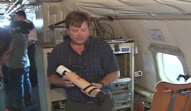
Photo credit: "
A device measures the storm's intensity. The information gathered is sent back to places like the Bay News 9 Weather Center, allowing our meteorologists to translate and report the data to you."
Threat Of Inland Flooding, Not Just Coastal Surge. Here's some good reporting from the
Christian Science Monitor: "
A slightly weaker hurricane Irene moved north toward North Carolina Friday morning as hurricane warnings and watches were posted along the coast from the North Carolina-South Carolina border to the mouth of the Merrimack River north of Boston. In addition to the storm surge Irene is expected push into coastal areas, inland flooding could be a serious problem because of the storm's size and track, forecasters say. While the eastern half of a storm tends to have the strongest winds, the western half tends to dump the most rain. Flood and flash-flood watches, issued by local National Weather Service forecast offices, have started to pop up along the eastern seaboard. In eastern Pennsylvania, southeast New York, and much of southwestern New England, soil moisture is significantly above normal for this time of year, says David Vallee, lead hydrologist at the Northeast River Forecast Center in Taunton, Mass. Intense summer thunderstorms have dropped enough rain over southern New England to push monthly rainfall totals for August from 2 to 5 inches above normal."
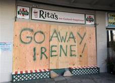
Photo credit: "A message is left for Hurricane Irene on one house, left, as a resident boards up another in anticipation of the arrival of Hurricane Irene in Nags Head, N.C., Thursday, Aug. 25, on North Carolina's Outer Banks." Charles Dharapak/AP
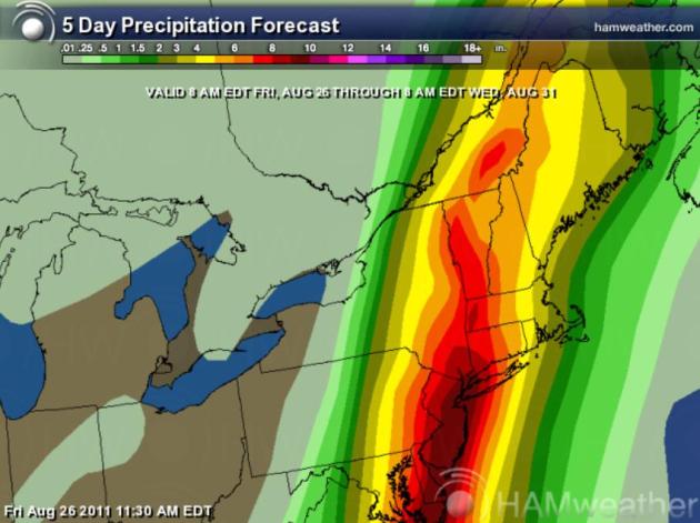
The Other Flood Threat. You'll hear a lot about storm surge in the coming days, the sudden rise in tides that precedes a hurricane's arrival. The other major concern: inland flooding triggered by torrential rains. Models are hinting at some 6-10" rainfall amounts from the Outer Banks of North Carolina northward to Norfolk, Rehobeth, Atlantic City and New York City.
 What You Need To Know To Prepare For Hurricane Irene
. Here's some
timely advice from wten.com in Albany:
- Have plenty of non-perishable food and water supplies on hand. Make sure battery-operated radios and flashlights are available and have an ample supply of batteries. You can also purchase hand-cranked flashlights and radios which do not need batteries. Have a first aid kit available and make sure there is an adequate supply of medicine on hand for those who need it.
- Know how to contact all family members at any time. Identify an out-of-town friend or family member to be the "emergency family contact." Make sure all family members have that number. Designate a family emergency meeting place where your family can meet in case you can't go home.
- Pay particular attention to relatives with special needs, small children and pets. Know where to relocate pets during a storm because most shelters will not allow pets. Most shelters will only accept "service animals" that assist people with disabilities.
- Prepare an emergency phone list of people and organizations that may need to be called. Include children's schools, doctors, child/senior care providers, and insurance agents.
- Know the local radio and television stations that will provide up-to-date official information during a storm emergency. Follow the news and emergency broadcast.
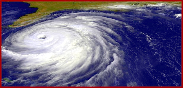
* file photo above of Hurricane Floyd from FEMA.
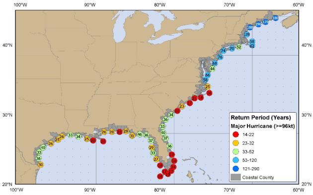
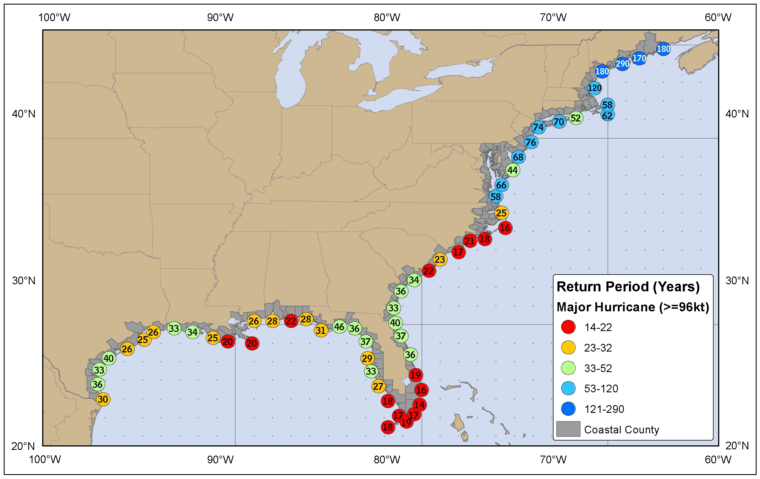
"Hurricane Alley". Here is a map from
NHC, showing the frequency of direct hurricane strikes along the U.S. coast. The Outer Banks of North Carolina see a direct strike every 16 years - New York City every 74 years.
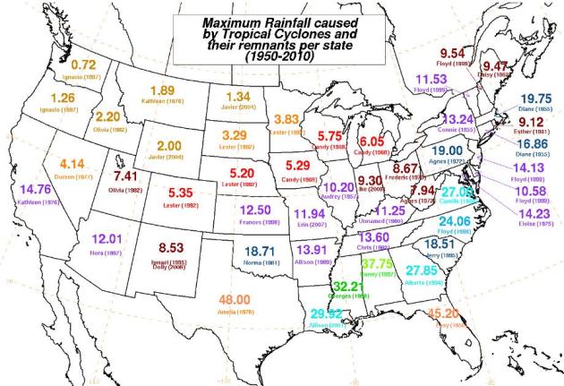 Maximum Rainfall From Tropical Cyclones
. I found this
graphic vaguely interesting. 45" from one hurricane in Florida (Hurricane "Easy" back in 1950 - love the name, btw). Know anyone named "Easy"? I hope not. Even Minnesota picked up 3.83" of rain from the remains of "Lester" back in 1992.
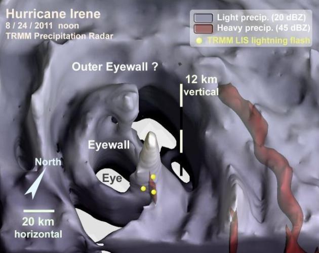
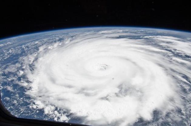
NASA's TRMM Satellite Analyzes Hurricane Irene In Rainfall, Lightning, Eyewall. Here's a post from
NASA, which is using sophisticated low-orbiting satellites to gather more raw data about Irene "
The Tropical Rainfall Measuring Mission Satellite known as TRMM has the ability to measure rainfall from space, and can also provide scientists with cloud heights, eyewall and lightning information. These images and captions of Hurricane Irene were provided by NASA hurricane scientist, Owen Kelley at NASA's Goddard Space Flight Center, Greenbelt, Md. In general, lightning in the inner core suggests the presence of strong updrafts and large ice particles. By implication, lightning suggests that convective cells are pumping a lot of latent heat energy into the tropical cyclone's central vortex, which is favorable for intensification. Hurricane eyewalls often are devote of lightning, as is the case for Irene on 8/23. But cat-3 Irene (on 8/24) did have lightning flashes in the eyewall, and there were many flashes during Irene's tropical storm phase (on 8/21)."
Cruise Ships Race Hurricane Irene To East Coast Ports. Here's an update from
USA Today: "Cruise ships are now speeding to their Eastern Seaboard home ports to end voyages before Hurricane Irene strikes. The storm is also altering ship schedules for cruises leaving this weekend. Plans may continue to shift as the storm's impact becomes evident. Passengers should check with the cruise line or their travel agent because ships may depart early. About 450 passengers missed their cruises last Sunday when two ships were forced to leave San Juan early due to the approaching storm.
At 11 a.m. ET, the National Hurricane Center in Miami reported that Irene was 330 miles south-southwest of Cape Hatteras, N.C., and outer rain bands of the storm were about to make landfall. It's now predicted the Category 2 storm will reach the coast Saturday and continue marching north. Hurricane warnings are now in effect from North Carolina to New Jersey.
Photo credit above: By William Thomas Cain, Getty Images
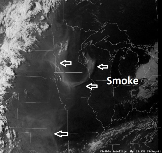
Outlook: Red (Smoky) Sunsets? Check out Thursday evening's visible satellite image, which clearly shows plumes of smoke from southern wildfires drifting into Minnesota. That could make for redder, more spectacular sunsets thru the weekend.
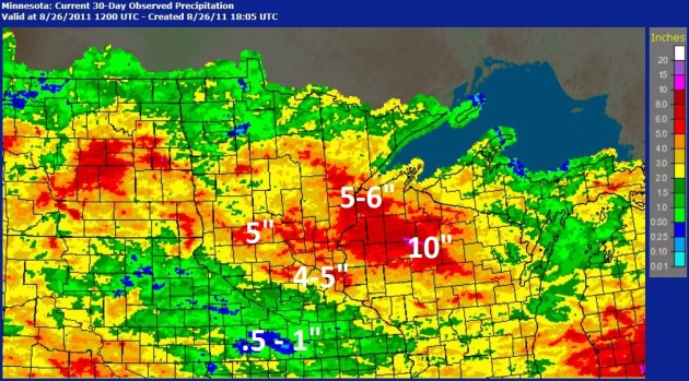
Wide Disparity In Rainfall This Month. Dr. Mark Seeley focuses on the big variations in rainfall across Minnesota so far this August in the latest edition of
Minnesota WeatherTalk: "
Thunderstorms have delivered large amounts of rainfall in northern and central areas of the state this month with many observers reporting monthly totals that already exceed average historical monthly values. Some of these reports include: 8.83" at Litchfield, 7.63" at Floodwood, 6.66" at Collegeville, 5,71" at Wright, 5.40" at Grand Rapids, 5.27" at Mora, 5.25" at Duluth, 5.23" at St Cloud, and 5.22' at Brainerd. Conversely, many southern Minnesota observers have reported significant rainfall deficiencies for the month of August. Less than one inch has been reported from several areas, and in southwestern Minnesota communities like Worthington and Marshall have reported less than half an inch, which has put some moisture stress on maturing corn and soybean crops."
* 30-Day Rainfall Map above courtesy of
NOAA.
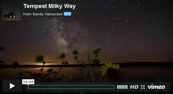
Jaw-Droppingly Gorgeous Video Captures Milky Way As Earth Spins. Check out this
video clip, sure to please astronomy buffs, courtesy of Yahoo News and Vimeo: "
Tempest Milky Way requires very little exposition before you watch the video. It's essentially 3 minutes of incredible, jaw-dropping scenery as the Earth spins, the stars revoling through the night sky as if riding a conveyer belt. The clarity and detail presented is absolutely astounding, giving you the chance to watch the sky in breathtaking color. Obviously, it reminds us a little of another timelapse video of the Milky Way, which was also quite a hit. Randy Halverson created this video entirely using views of the sky in South Dakota. He was challenged getting good shots of storms and stars. Since all of the scenes were shot via timelapse photography, it wouldn't take much to ruin a chunk of footage. If the storm wasn't moving just the right way, or if the lightning wasn't quite right, then Randy couldn't use the images. This video became an endeavor of careful patience and detail-oriented composition."
Smoky Sunsets
Repeat after me: "Yes, we see cold winters. It snows. We cope. Minnesota does experience big storms, but at least OUR STORMS DON'T HAVE NAMES." We sympathize with friends & family in the northeast, grappling with the impact of Irene. The situation doesn't look quite as dire as it did 48 hours ago; Irene sparing Washington D.C. and New York City the worst of the storm surge. Think of it this way: the same cold fronts that we like to gripe about "inoculate" Minnesota from having to ever worry about tropical storms - one of the FEW weather phenomena we don't have to fixate on.<p>The Outer Banks of North Carolina get hit today, the northeastern seaboard Sunday with the greatest potential for flooding from coastal New Jersey to Long Island.
And to think, before 1961, before the era of weather satellites, forecasters relied on ship reports to know where hurricanes were!
Smoke from southern wildfires may spark a few spectacular sunsets in the coming days - today's weather ideal for power- munching your way thru the State Fair. A stray shower may pop over western Minnesota; comfortable 70s this weekend giving way to a warming trend next week.
No 90s, no insipid humidity & no hurricanes.
Climate Change May Not Cause Hurricanes, But It Can Make Them Much Stronger. Here's a timely post from
treehugger.com: "
The perhaps inevitable question: So what's the connection between climate change and Hurricane Irene? The stock answer is that it's hard if not impossible to blame any extreme weather event and climate change, but it does contribute to making hurricanes, heat waves, droughts, even blizzards (for a while at least) more likely. As for hurricanes, one of the factors contributing to their strength is warm ocean water--hurricanes need ocean surface temperatures to exceed 79°F. Something which is increasing, as most TreeHugger readers will probably know. Union of Concerned Scientists explains how this figures into hurricane formation: Two factors that contribute to more intense tropical cyclones-ocean heat content and water vapor-have both increased over the past several decades--ocean heat content and water vapor--have both increased over the past several decades. This is primarily due to human activities such as the burning of fossil fuels and the clearing of forests, which have significantly elevated carbon dioxide (CO2) levels in the atmosphere. CO2 and other heat-trapping gases act like an insulating blanket that warms the land and ocean and increases evaporation. The world's oceans have absorbed about 20 times as much heat as the atmosphere over the past half-century, leading to higher temperatures not only in surface waters (e.g., depths of less than 100 feet) but also down to substantial depths, with the most severe warming occurring in the first 1,500 feet below the surface. As this warming occurs, the oceans expand and raise sea level. This expansion, combined with the inflow of water from melting land ice, has raised global sea level more than one inch over the last decade."
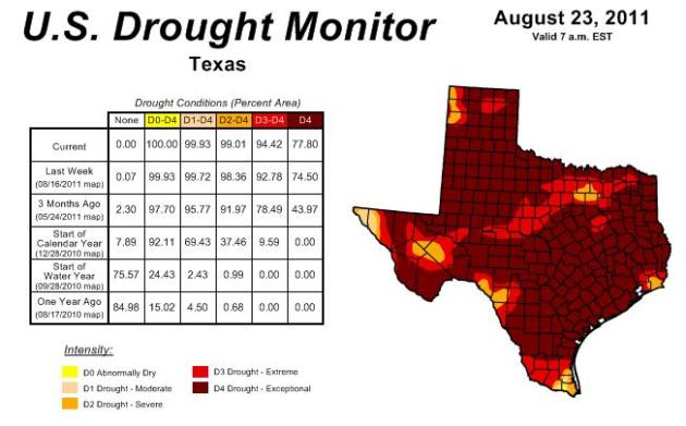
Assessing Climate Change In A Drought-Stricken State. The story from the
New York Times: "
Texas has endured its worst one-year drought in recorded history. And the hottest July. August is on course to be hotter still, setting another record. So, is this the result of climate change? Scientists hedge, particularly when it comes to the drought, because they are reluctant to pin any single weather event on climate change. They point to La Niña, an intermittent Pacific Ocean phenomenon that affects storms, as the immediate cause. “We can’t say with certainty whether this particular drought is in and of itself a product of climate change,” said David Brown, a regional official with the National Oceanic and Atmospheric Administration. However, Dr. Brown added, these kinds of droughts will have effects that are “even more extreme” in the future, given a warming and drying regional climate. Climate change, or global warming, has become a hot topic on the presidential campaign trail. Most scientists, including Dr. Brown, say humans are altering the climate by adding heat-trapping gases like carbon dioxide and methane to the atmosphere. Even so, Gov. Rick Perry, campaigning this month in New Hampshire, declared himself a “skeptic” that climate change is the result of human actions."
* map above courtesy of NOAA's
Drought Monitor.
Gallup: Americans Less Likely To View Climate Change As A Threat. Here's an article at
zdnet.com: "
Oh goody, a new Gallup poll for the politicians to play with over the weekend! The research organization is reporting that residents are really no more or less aware about climate change during 2010 than they were several years before, in 2007 and 2008. In the United States, for example, the number of people say they know a great deal about global warming or climate change is off 1 percent to 96 percent. What is off significantly, however, is both the percentage of Americans who believe that global warming is a serious treat and the number of people who think that it comes from human causes or both human and natural causes."
 Mitt Romney's Position On Climate Change
. Here's a blog entry from the
Washington Post: "
The Romney campaign argues that the candidate has been consistent in his stance on climate change. The campaign has a point. Romney stressed his uncertainty about global warming earlier this year, too; Phil Rucker quoted him in June:
“I don’t speak for the scientific community, of course, but I believe the world’s getting warmer,” he said. “I can’t prove that, but I believe based on what I read that the world is getting warmer. And number two, I believe that humans contribute to that. I don’t know how much our contribution is to that, because I know that there have been periods of greater heat and warmth in the past, but I believe we contribute to that.”
Meanwhile, though Romney on Wednesday said, “I don’t know if [climate change is] mostly caused by humans,” he also said, “Do I think humans contribute to it? Yes.” So Romney has been more consistent than I gave him credit for. Yet, that still makes him consistently timid on the science, particularly when it comes to the recent temperature record — the warming that NOAA calls “unequivocal” and that Romney shouldn’t need to cast in such uncertain terms in the first place."


