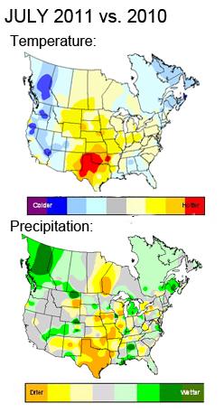
Warmest July in 50 years for the continental USA (source: Planalytics).
27 days above 100 in Oklahoma City during July.
"...The highest recorded temperature in Oklahoma City history is 113 degrees, set Aug. 11, 1936. Wednesday's predicted high is 111 degrees. The highest temperature so far in 2011 was 110 degrees on July 9." - article in The Oklahoman.
32 days in a row above 100 at Dallas (second longest streak on record). All-time record for consecutive 100-degree days at DFW: 42 days in 1980. We may come very close to that mark in 2011.

Close Encounter. Tropical Storm Emily is passing just south of Puerto Rico - some of the outer bands of the storm capable of heavy showers and storms, but the roughest surf (and heaviest rain squalls) are passing 50-125 miles south of San Juan. Radar loop courtesy of the Bio-Optical Oceanography Laboratory in Puerto Rico.
753. According to SPC the number of April, 2011 tornadoes has been revised to 753. The old April record was 267, in 1974. Almost THREE TIMES more than the previous record. The tornado record for any month was 542, set in 2003.

"...Since the 1970s, there has been no upward trend in the sun’s brightness." - article on the role of the sun in climate change from Yale's Environment 360. More details below.
"...Last month we set a record for the highest dew point ever recorded at the Minneapolis-St. Paul International Airport. Chicago recorded the very same thing. Yesterday, the news came that there is more land in the United States in extreme drought than in the history of the country. And it has been wet, too. In Alexandria, for instance, folks can't raise their docks any higher, so many people are simply pulling them out. Of course, Australia and Pakistan have seen more rain in the last five months than they've seen in their history. The Horn of Africa is in a drought worse than the one currently hammering Texas. Is this just weather? Or, is it climate?" - Op-Ed from Don Shelby at Minnpost.com, details below.
KSTC - - gust 63 mph at 9:05 a.m. EDT / 8:05 a.m. CDT - - Regional Airport, St. Cloud, Minnesota
STCSD - - gust 59 mph at 9:00 a.m. EDT / 8:00 a.m. CDT - - St. Cloud State University EAS Department
KCFE - - gust 54 mph at 9:14 a.m. EDT / 8:14 a.m. CDT - - Municipal Airport, Buffalo Minnesota
KBBB - - gust 53 mph at 7:33 a.m. EDT / 6:33 a.m. CDT - - Municipal Airport, Benson Minnesota
Straight-Line Wind Reports From Minnesota On Tuesday, courtesy of NOAA.
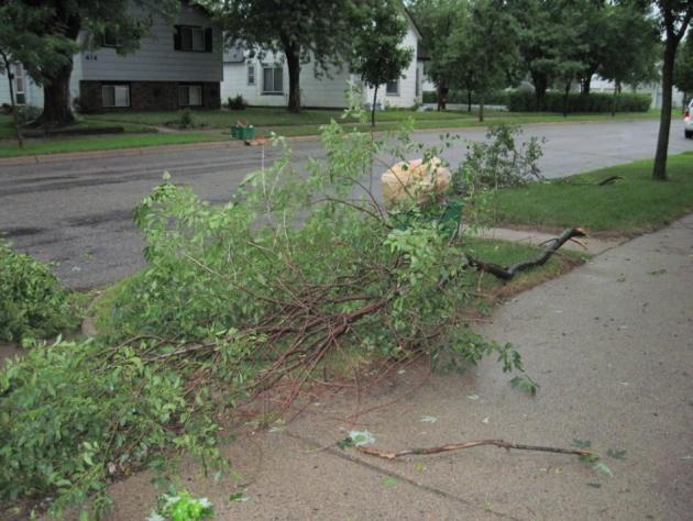
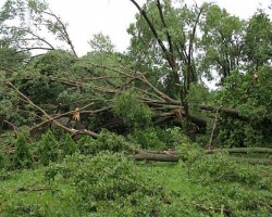
Sweating Out The Summer: Impressively Oppressive. The Star Tribune's Bill McAuliffe has a terrific summary of a month we'd all probably prefer to forget. July brought historic dew points and humidity levels to Minnesota, and much of the USA east of the Rockies: "July was the fifth-hottest July on record in the Twin Cities. What? Only fifth? Thanks to copious rain and humidity, the midsummer discomfort approached epic proportions, even without record-setting temperatures. August usually brings some relief, but Monday's downpours and dew points didn't seem to reverse any trends. And for better or worse, summer's a long way from over. "It's either raining like crazy, or it's extremely hot," said Kevin McNealey, who felt the impact in a distinctive way as owner of Blue Ladder Painting in Minneapolis. "The paint either dries too slow or dries too fast." McNealey said his work is down about 20 percent this year, though it's unclear how much is due to weather and how much is due to the economy. "When the end of the season comes around, sometimes people say, 'I should have gotten that painted.' I'm hopeful that's going to be the case," he said. Rainfall for July, 5.23 inches, was 29 percent above normal, and rain fell on 13 days. For those whose work wasn't affected, it fell on four out of five weekends. The high temp on July 1 reached 99, and nine more days in the 90s followed. No daily high temperature records were set, but several others were, indicating how oppressive the conditions were." (tree damage photo courtesy of D.J. Kaywer, a meteorology student at SCSU - and an invaluable member of the WeatherNation team).

July Was The Hottest Month On Record In Oklahoma. More details from newsok.com, powered by The Oklahoman: "Oklahoma's record-breaking heat wave made July the hottest month on record in the state. According to data from the Oklahoma Mesonet, the average temperature in Oklahoma in July was 89.1 degrees, breaking the previous record of 88.1 degrees set in July 1954, said Gary McManus, associate climatologist at the Oklahoma Climatological Survey in Norman. Records have been kept of statewide averages since 1895. The statewide average rainfall total was 0.70 inches, more than 2 inches below normal and making it the fourth-driest July on record. Oklahoma City's average temperature of 89.2 degrees in July topped the previous record of 88.7 degrees from August 1936. Oklahoma City had 27 days in July with a high temperature of at least 100 degrees, once again the most for any month in its history."
- July 4th weekend was the warmest since 2003 driven by sweltering heat and helping to drive traffic to beaches, water attractions, and movie theaters.
- The first week in July set 1,500 weather records due to heavy regional rainfall in the South Atlantic and East South Central regions and heat waves across the South Central Plains.
- Week 2 experienced similar regional trends of cooler temperatures on the West Coast and heat pushing from the Rockies to the East Coast. NYC and Philadelphia hit record highs as a part of 2,600 weather records for week 2.
- Week 3 of July 2011 was the warmest individual week in over 18 years. Several locations had their highest temperature ever recorded, including Newark, NJ (108F), Washington, DC (105F), and Hartford, CT (103F).
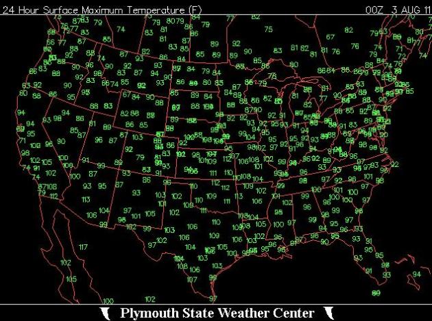
Hottest Day Yet. Just when you think it couldn't get any hotter in the central and southern USA: 110 at Dallas, 109 at Oklahoma City, 112 at Kansas City, 106 Little Rock, 112 Tulsa. Graphic courtesy of the Plymouth State Weather Center.
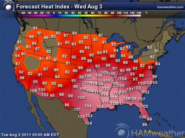
Ditto. Relief for New England, the Great Lakes and the Upper Midwest as dew points drop into the 50s, thanks to a fresh transfusion of Canadian air, but more record heat will grip the central and southern Plains, the Mississippi River Valley and Mid South, into the Carolinas and Florida. Map courtesy of Ham Weather.

Tropical Storm Emily. The enhanced infrared satellite loop (see the latest animation from wsi.com) showed Emily becoming more organized, wrapped up into a tigher, more concentric circle of clouds late Tuesday. Sustained winds are 50 mph and additional strengthening is likely today as Emily passes over warm, 85-degree water in the Caribbean. Hispaniola (Haiti and the Dominican Republic) may see a direct strike with some 10-15" rains, temporarily weakening Tropical Storm Emily, which is forecast to make a turn to the north, possibly tracking over the Bahamas by Saturday.
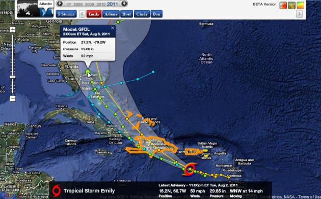
Emily's Projected Track. Tropical Storm Warnings in orange - most models take Emily across Hispaniola (where some weakening will take place), and then northwestward across the Bahamas, where further intensification is possible. The GFDL strengthens Emily to a 92 mph. hurricane, 100 miles east of Vero Beach, Florida by 2 am Saturday morning. Data courtesy of NHC and Ham Weather.


- Garage doors: If you want a replacement door, purchase a reinforced, wind-rated model. You can reinforce garage doors at their weakest points, using vertical brackets on each panel. Wood and light gauge metal guards, and hinges can be used. Experts suggest checking stores to see if retrofit kits are available for your garage door model.
- Roofing: If your roof needs replacement, a new one can be installed to meet stronger building codes adopted in 2002. Here are some tips we found on bracing and other roof strengthening and securing roofs to walls.
- Trees: Trim all tree limbs that could fall on your home before stormy weather is approaching.
- Windows: Install hurricane shutters and secure them in high winds. Protecting windows prevents wind and water damage and keeps the roof more secure. Duct tape will not suffice."
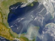
Satellite image of smog from NASA.
Air Pollution Makes Heat Even Worse. Here's a timely Op Ed from Ken Bradley, from Environment Minnesota:
"The heat wave sweeping the nation means more than just uncomfortable temperatures for all of us. It can also mean real threats to people’s health when excessive heat and sunlight mix with air pollution from power plants and cars, smog pollution is formed in the air, also known as ground-level ozone. Smog is the most pervasive air pollutant in the country – with nearly half of all Americans (48 percent) living in areas where the air is often unhealthy to breathe because of high smog levels. Minnesota’s recent heat wave has impacts on our population and pollution has made the situation even worse.
Breathing in ground-level ozone, though it doesn’t feel any different, is damaging to the lungs, and studies show that on days with elevated levels of ozone, children and adults suffer more asthma attacks, increased respiratory difficulty, and reduced lung function. A recent report by the non-profit group Environment Minnesota, titled Dirty Energy’s Assault on our Health: Ozone Pollution, suggests that children who grow up in areas with high levels of smog may develop diminished lung capacity, putting them at greater risk of lung disease later in life. Even for healthy adults, repeated exposure to smog over time permanently damages lung tissue, decreases the ability to breathe normally, exacerbates chronic diseases like asthma, and can even kill. The National Institute of Health estimates that 5,000 asthma related deaths occur each year with air pollution playing a significant role."
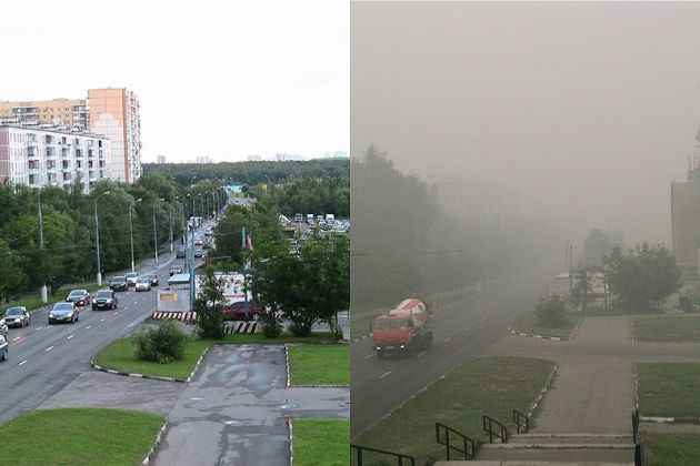
Before/After smog image of downtown Moscow courtesy of NOAA.
"There are many tools in place to help protect children and families from air pollution’s dangerous health effects. Every state monitors the air quality on a regular basis and alerts the public if the air is unhealthy to breathe and if people are advised to stay indoors or avoid outdoor exercise. The Air Quality Index (AQI) is the main tool for communicating this information to the public. The index has six color-coded categories ranging from green (good air quality) to purple (hazardous air quality). At the “orange-alert” level, the air pollution levels are high enough to affect sensitive populations, including children, older adults, and people with asthma and lung disease. At the “red-alert” level, everyone may begin to experience some adverse health effects, and members of sensitive groups may experience more serious effects. The Minnesota Pollution Control Agency releases these reports and anyone can sign up for their alerts.
While knowing the air quality is half the battle for protecting your health, there is a lot that is being done behind the scenes to reduce dangerous air pollution across the board. The U.S. Environmental Protection Agency is developing an updated standard to limit smog-forming pollution from power plants and cars across the country to protect public health, based on the latest air quality and health science. A strict science-based standard means less pollution allowed from power plants and cars, and healthier air for kids to breathe. While we can’t control the weather, we can impact the pollution that makes these hot summer days even worse for our families and communities."
- Ken Bradley, Environment Minnesota

(photo courtesy of NASA).
The Trees Are Nervous
Welcome to what will almost certainly go down into the record books as the most humid summer on record for Minnesota and much of the Upper Midwest. Dew point is an (absolute) measure of how much water is in the air. According to Pete Boulay at the MN Climate Office MSP has suffered thru 98 hours of 75+ dew points, a new record. Average is 18 hours.
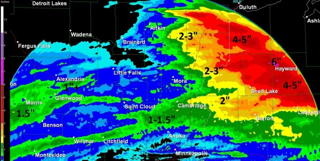
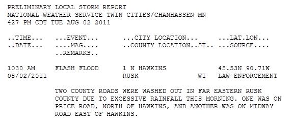
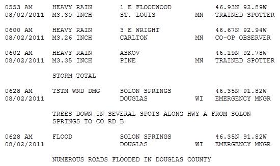
Who cares? When there's this much water in the air there's more fuel for violent T-storms capable of flash floods & extreme winds. Tuesday's severe storms unleashed 3-6" rain, nearly 2 month's worth of rain up north; reports of mudslides near Duluth.
America's North Woods are now under siege: the combination of saturated soil & hurricane-force wind gusts has toppled thousands of trees in recent weeks - a symptom of the "new normal".
It may have been the hottest July in over 50 years for the USA. July was the hottest month EVER for Detroit, Oklahoma City, Amarillo & Wichita Falls. Dallas may go 6 weeks/row above 100.
* photo above courtesy of WJON-Radio.
Climate Stories...
Climate Stories...


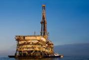
"When it comes to understanding the ebb and flow of U.S. energy policy, most insiders will acknowledge that natural gas has a lead. But with that bravado must come a bit of compliance -- namely in the form of new environmental regs. The U.S. Environmental Protection Agency has proposed new rules for natural gas explorers. That is, those entities that produce shale-gas must reduce their smog-related emissions by 95 percent. But the EPA says that would be done by using proven technologies that can capture natural gas that currently escapes into the air -- gas that would be made available for sale. Environmental groups are calling the proposal a fair deal, meaning that the capture of the gas would eliminate not just volatile organic compounds that make up smog but also those involving methane, as a byproduct. Methane is a greenhouse gas that is much more potent than carbon. The oil and gas industry is said to release 40 percent of all U.S. methane emissions, which is the largest single source, says EPA. "