
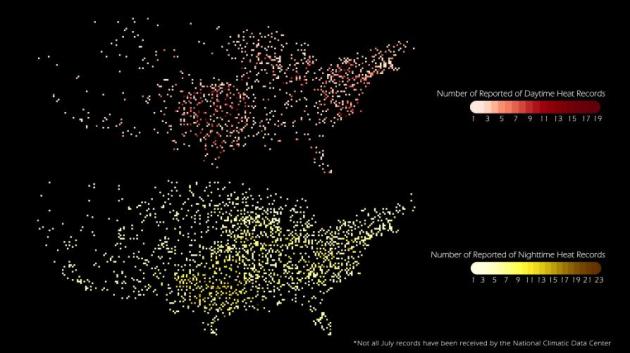
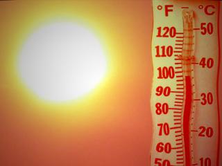
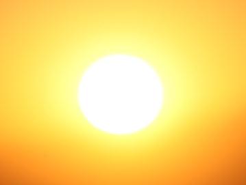
2,755 maximum temperature records set nationwide in July across the USA (preliminary count from NOAA).
6,171 minimum temperature records established in July, from coast to coast (source: NOAA).

A Reinvigorated Tropical Storm Emily? NHC says there's a 70% chance that a tropical wave will redevelop into Tropical Storm Emily. Details below.
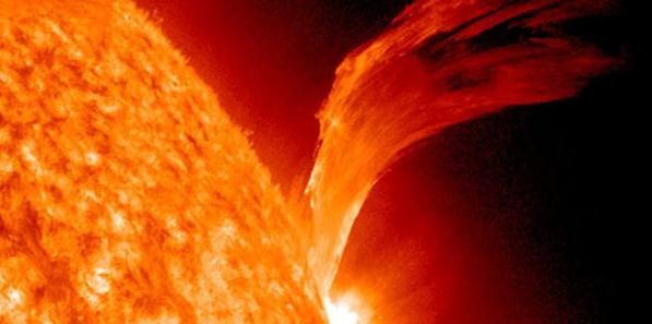
Solar Flares May Impact Communications This Weekend. Don't be surprised if your GPS acts a little hinky this weekend, due to a major solar flare on August 5. Politico has more details. A longer story from spaceweather.com below.
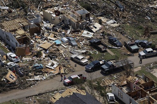
"...More than 9.1 million cubic yards of debris have been moved in just over three months," most of the 10 million originally estimated, Bentley says. The debris would fill 102,000-seat Bryant-Denny Stadium, the Tuscaloosa home of the University of Alabama's Crimson Tide, and form a stack about a mile high." - USA Today article below on the clean-up in Tuscaloosa after record tornadoes swept across the Alabama city this spring. (photo credit: blog.al.com).
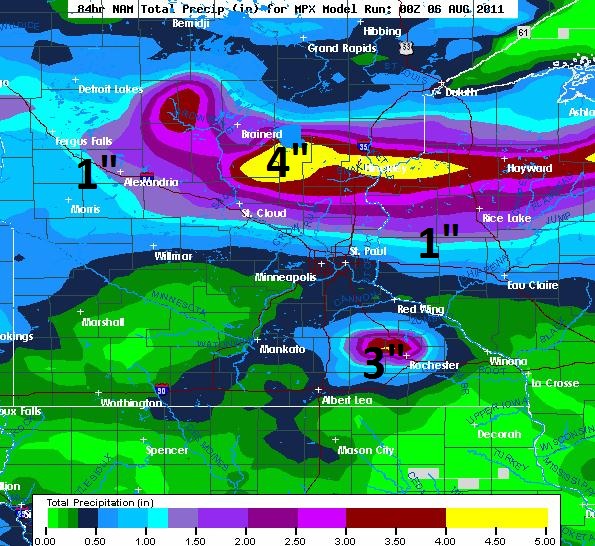
Potential For Flash Flooding over Central/Northern Minnesota. The latest NAM/WRF model prints out a narrow band of 2-4" rains from near Little Falls and Brainerd east to Hinckley, another rainy bullseye of 2-3" near Rochester. The latest NAM model prints out .47" for the MSP metro, considerably more over the northern suburbs.
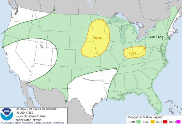
Saturday Severe Risk. An advancing cool front may spark a severe storm outbreak from the eastern Dakotas into Minnesota and western Iowa, another region of potentially severe storms from Indianapolis to Columbus, southward to Louisville. Source: SPC.
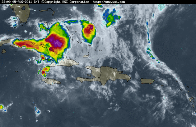
A Near Death (Tropical) Experience? Enhanced IR satellite loop courtesy of wsi.com. Tropical Storm Emily weakened over Hispaniola, where it dumped out 10"+ rains, triggering extensive flash flooding across Haiti and the Dominican Republic. Out over the (warm) waters of the Bahamas the storm shows renewed signs of strengthening - it may regain tropical storm status later today, still capable of impacting the eastern coast of Florida with strong winds, high surf and heavy rain squalls (although the odds of a full-blown Hurricane Emily impacting the coastal USA are slim). NHC nows says there is a 70% probability that this tropical wave will regenerate into Tropical Storm Emily. More details from NHC:
SATELLITE IMAGES...SURFACE OBSERVATIONS...AND RADAR DATA FROM CUBA
INDICATE THE REMNANT LOW PRESSURE SYSTEM OF FORMER TROPICAL STORM
EMILY HAS REMAINED NEARLY STATIONARY ABOUT MIDWAY BETWEEN THE
CENTRAL BAHAMAS AND THE NORTH-CENTRAL COAST OF CUBA. THUNDERSTORM
ACTIVITY HAS INCREASED AND BECOME A LITTLE BETTER ORGANIZED NEAR
THE SURFACE CENTER...AND UPPER-LEVEL WINDS ARE GRADUALLY BECOMING
MORE CONDUCIVE FOR A TROPICAL DEPRESSION TO FORM DURING THE NEXT
DAY OR SO. THIS SYSTEM HAS A HIGH CHANCE...70 PERCENT...OF
REGENERATING INTO A TROPICAL CYCLONE DURING THE NEXT 48 HOURS AS
IT MOVES TOWARD THE NORTHWEST AT 10 MPH. AN AIR FORCE RESERVE UNIT
RECONNAISSANCE AIRCRAFT IS SCHEDULED TO INVESTIGATE THE LOW ON
SATURDAY...IF NECESSARY. INTERESTS IN THE CENTRAL AND NORTHWESTERN
BAHAMAS SHOULD MONITOR THE PROGRESS OF THIS SYSTEM. REGARDLESS OF
DEVELOPMENT...THIS DISTURBANCE WILL PRODUCE GUSTY WINDS AND LOCALLY
HEAVY RAINFALL OVER PORTIONS OF THE CENTRAL AND NORTHWESTERN
BAHAMAS TONIGHT AND SATURDAY.

Note: at the time the dew-point reached the record 88F, wind speeds were decreasing and the air temperature rising. This suggests there were local influences that helped drive the dew-point to this extreme level."

From the standpoint of tropical-like dewpoints, summer of 2011 has brought more hours with a dewpoint of 75 F or higher than any other summer in history for the Twin Cities.......... "
( http://www.climate.umn.edu/doc/journal/muggy_2011.htm )
More Record Heat on Friday. Thanks to NOAA and Chad Merrill at Earth Networks:
...RECORD HIGH TEMPERATURE SET AT AUSTIN CAMP MABRY...
A RECORD HIGH TEMPERATURE OF 106 DEGREES WAS SET AT AUSTIN CAMP
MABRY TODAY. THIS BREAKS THE OLD RECORD OF 105 SET IN 1951.
...RECORD MAXIMUM TEMPERATURE TIED AT WICHITA FALLS... THE MAXIMUM TEMPERATURE AT SHEPPARD AIR FORCE BASE IN WICHITA FALLSTODAY WAS 110 DEGREES. THIS TIES THE RECORD HIGH FOR AUGUST 5...WHICH OCCURRED IN 1964. TEMPERATURE RECORDS FOR WICHITA FALLS DATE BACK TO 1923. ...RECORD HIGH TEMPERATURE SET AT MIDLAND... A RECORD HIGH TEMPERATURE OF 104 DEGREES WAS SET AT MIDLAND TODAY.THIS BREAKS THE OLD RECORD OF 103 SET IN 2003. ...RECORD HIGH TEMPERATURES SET ACROSS THE AREA... A RECORD HIGH TEMPERATURE OF 103 DEGREES WAS RECORDED AT AMARILLOTODAY. THIS BREAKS THE OLD RECORD OF 102 SET IN 1954. A RECORD HIGH TEMPERATURE OF 102 DEGREES WAS RECORDED AT BORGERTODAY. THIS TIES THE OLD RECORD OF 102 SET IN 2009 RECORD HIGH TEMPERATURE SET AT AUSTIN CAMP MABRY... A RECORD HIGH TEMPERATURE OF 106 DEGREES WAS SET AT AUSTIN CAMPMABRY TODAY. THIS BREAKS THE OLD RECORD OF 105 SET IN 1951. ...RECORD HIGH TEMPERATURE SET AT WACO... A RECORD HIGH TEMPERATURE OF 106 DEGREES WAS SET AT WACO TODAY.THIS TIES THE OLD RECORD OF 106 SET IN 2001. ...RECORD HIGH TEMPERATURE SET AT DALLAS FORT WORTH... A RECORD HIGH TEMPERATURE OF 107 DEGREES WAS SET AT DALLAS FORT WORTH TODAY.THIS BREAKS THE OLD RECORD OF 106 SET IN 1964. ...RECORD HIGH TEMPERATURE SET AT FAYETTEVILLE ARKANSAS... A RECORD HIGH TEMPERATURE OF 107 DEGREES WAS SET AT FAYETTEVILLE ARKANSAS TODAY.THIS BREAKS THE PREVIOUS RECORD OF 101...SET IN 1956. .RECORD HIGH TEMPERATURE SET AT TULSA OKLAHOMA... A RECORD HIGH TEMPERATURE OF 111 DEGREES WAS SET AT TULSA OKLAHOMA TODAY.THIS BREAKS THE PREVIOUS RECORD OF 110...SET IN 1964. ...RECORD MAXIMUM TEMPERATURE SET AT OKLAHOMA CITY...
THE HIGH TEMPERATURE TODAY AT WILL ROGERS WORLD AIRPORT IN OKLAHOMA
CITY WAS 110 DEGREES. THIS BREAKS THE DAILY RECORD HIGH OF 106
DEGREES... WHICH OCCURRED IN 1964.
...RECORD HIGH TEMPERATURE SET AT JOPLIN MO... A RECORD HIGH TEMPERATURE OF 107 DEGREES WAS SET AT JOPLIN MOTODAY. THIS BREAKS THE OLD RECORD OF 103 SET IN 1956.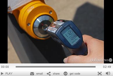
Surface Temperature At Dallas Playground Reaches 180 As Heat Wave Rolls On. Unbelievable. Thanks to shoppingblog.com and the Dallas Morning News for this one - check out the video clip: "Dallas has been baking in a heat wave that is stressing the state's power grid, and making residents miserable. Rolling blackouts across the state were just narrowly avoided yesterday. Dallas Morning News intern Marianne Brown was sent outside during the 109 degree heat to get an idea of how hot surfaces are around Dallas. She used a laser heat gun to check the temperature on various surfaces. In one outdoor playground, the the climbing wall is 150 degrees. The climbing handles are 170 degrees. The ladder is 150 degrees. And the surface of the playground reads 181 degrees. Feel like sitting in the shade? The bench reads 132 degrees. Residents can get burned just opening their car doors."

Drought Scorches Texas - And The Record Books, Says Texas A&M Professor. More (remarkable) details on the heat wave gripping the Lonestar State from Texas A&M's GeoNews: "COLLEGE STATION, July 6, 2011 – The months-long Texas drought is sapping the record books bone dry and is racking up dire statistics that have never been reached since reliable record-keeping was started 116 years ago, according to figures from Texas A&M University researchers. Don Conlee, instructional associate professor of atmospheric sciences who, along with graduate student Brent McRoberts, also assists State Climatologist John Nielsen-Gammon with recordkeeping, confirms that the period from February through June was by far the driest on record with a statewide average of 4.26 inches of rain. The next driest occurred in 1917 with 6.45 inches. Also setting records: March-June, driest on record; January-June, driest on record; December-June, driest on record; November-June, driest on record; and October-June, driest on record. They note that official weather keeping began in 1895 in Texas. Drought researchers, emergency managers and state and federal officials will convene in Austin on Thursday (July 7) for a special Southern U.S. Drought Impacts & Assessment Workshop. As for June, it was most definitely time to crank up the AC unit: 2011 marked the hottest June ever in Texas with an average of 85.2 degrees, breaking the previous mark of 84.9 set in 1953. “June was not only the warmest June in Texas history, it comes in as the fourth warmest month ever, which usually goes to a July or August time period,” Conlee notes."
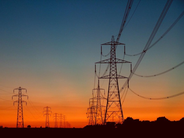
Heat Wave Pushes Texas Power Grid Into Red Zone. Reuters has the details of what an extended, 100-degree heat wave, is doing to the electrical grid in Texas: "(Reuters) - The Texas power grid operator has scrambled this week to meet soaring electricity demand in the face of a brutal heat wave, and residents of the second most populous U.S. state are one power plant shut-down away from rolling blackouts. Power demand for Electric Reliability Council of Texas, Inc, or ERCOT, which runs the power grid for most of the state, hit three consecutive records this week as Texans cranked up air conditioners to escape one of the hottest summers on record. The grid operator on Thursday cut power to some big industrial users, and businesses and households face a repeat of the rolling blackouts they faced in February, when a bitter cold snap interrupted power supplies." (photo credit: rechargetexas.com and the Dallas Morning News).
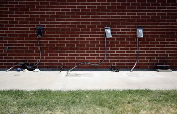
Air Conditioners Are Hot Targets For Dallas-Ft. Worth Thieves. Some people will do anything to keep their cool, even steal their neighbor's air conditioning unit. Dallasnews.com has the story: "Marlene Arnold feels like these thieves took from the Almighty himself. Last week, someone pilfered the air conditioners from Chisholm Baptist Church in Rockwall, leaving only the pipes jutting out of the brick walls and congregants sweltering through a Sunday service. Ten units were gone. “I just can’t imagine anybody that would steal from God, and that building is God,” she said. Authorities say air-conditioner thefts are on the rise: Whether they’re after the copper inside, or mammoth central air units, stealthy but brazen crooks are leaving people boiling in more ways than one. “I feel violated,” said Paula Moore, still angry at the sneak who took her entire outdoor unit last week. Moore was at her home off Interstate 20 in Rylie when it began to get hot. She checked the thermostat to see if the air conditioning was on. She checked the breaker box, and it was on, too. When she looked outside, her unit was gone."
- Texas state climatologist John Nielsen-Gammon reported that data from the previous 12 months indicate the state is now in its worst one-year drought on record. He also reported that preliminary data indicate July was the warmest month ever recorded in Texas, based on records dating to 1895. Various low-rainfall records were set last month, too. “Never before has so little rain been recorded prior to and during the primary growing season for crops, plants and warm-season grasses,” said Nielsen-Gammon, a Texas A&M University professor.
- With air conditioners running full-throttle to counter the searing heat wave gripping Texas, ERCOT, the agency that operates the power grid in most of the state, reported three consecutive electricity-use records were set Monday through Wednesday. On Thursday, ERCOT first cut back power to some industrial users. Then it appealed for broader conservation actions, saying electricity demand had created a “high probability” of rolling blackouts across the state. Finally, it lowered the emergency level without ordering planned outages. An agency official said this summer’s power demand has been “far beyond” expectations."
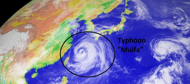
Eastern China On Alert As Typhoon Muifa Approaches. An update from China's Xinhuanet News Agency: "BEIJING, August 5 (Xinhuanet) – Civil affairs agencies in areas along China's eastern coast have been alerted to prepare for typhoon Muifa as it approaches the mainland. The storm decreased in strength on Wednesday night, going from a super typhoon to a severe typhoon. However, it is still expected to be one of the most powerful storms to hit China in recent years. Typhoon Muifa is heading towards China's southeastern coast at a speed of 13 km per hour. Meteorological authorities predict that Muifa will likely make landfall on Saturday night and cause significant damage. China has issued an orange alert for high waves in the East China Sea as the typhoon approaches. Orange is the second-highest level in the country's four-level high wave alert system. The eastern region of the East China Sea is likely to see waves of 6 to 9 meters high. The Ministry of Civil Affairs has issued a circular ordering its subordinate agencies in China's eastern and southeastern cities to monitor the situation closely and carry out disaster relief operations in a timely manner."
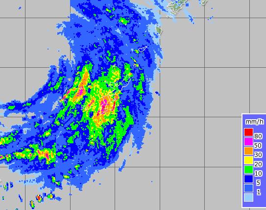
Muifa's Outer Bands Hitting Okinawa. Latest radar courtesy of JMA, the Japanese Meteorological Agency.
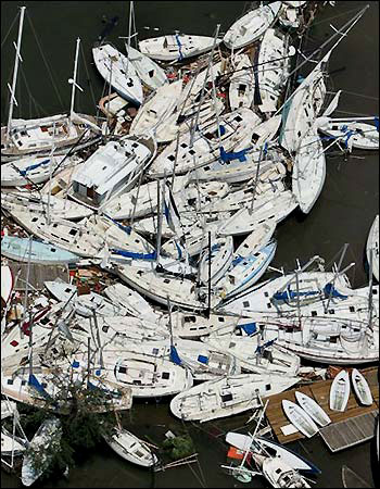
Boating: Hurricane Season Is Here. Silive.com has a solid article reminding boat owners what steps they need to take to prepare for hurricanes: "The 2011 Hurricane season is here and the National Weather Service is now predicting an average season. The tropics are starting to make the news as storms start to form. It has been very quiet so far. Are you ready for a big storm? How would you prepare your boat and yourself? When strong winds and severe weather is predicted, do not stay on the boat. A boat can be replaced but a life cannot. What should you do to be prepared? First decide if you are going to leave the boat at the dock or mooring or have it hauled to land. Many insurance companys will pay for you to haul your boat before a storm. Check your policy. Make your decision early. Do this before a Hurricane watch is posted (36 hours before storm hits). For boats to survive a hurricane it requires both boaters and marina operators to make a coordinated effort to minimize storm damage. If you elect to stay in the water prepare your boat by putting out extra lines on your cleats and tie to a different ring or cleat than the original line in case it fails. Put out extra fenders to prevent your boat from hitting the dock. Be sure to use chafing gear on your lines so they will not fray and fail to hold your boat secure. If you are on a mooring, make sure your chain and anchor are in good shape. Have it inspected NOW! Double up on the mooring lines and use a different cleat in case the first cleat fails." (photo credit: trinidadcruisingguide.com).
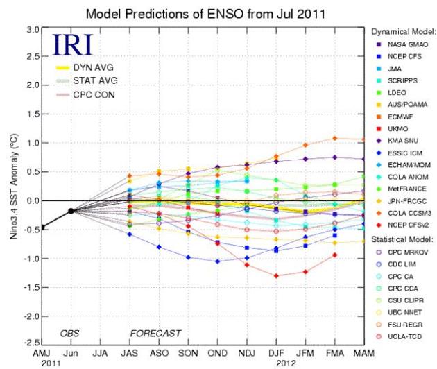
A (Weak) La Nina Pattern Returning By Winter? The current "ENSO-neutral" (Pacific Ocean water temperatures close to normal) is expected to continue into autumn, but NOAA reports an "equal chance" of ENSO Neutral or even a weak La Nina (cooling) of Pacific water this upcoming winter. If (and it's a big if) we do slide back into a cooling La Nina phase - it could tilt the odds in favor of a snowier winter. Too early to say - we'll keep an eye on it. Here's the latest from NOAA:
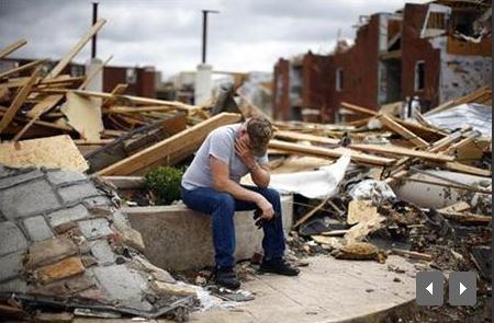
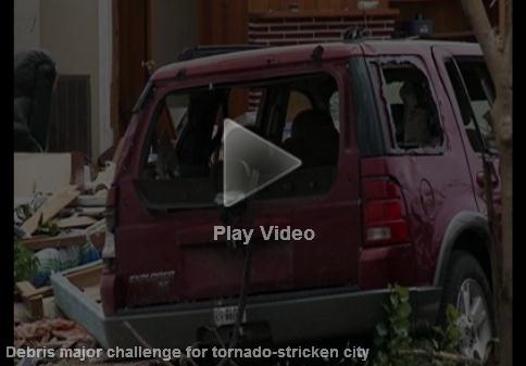
Alabama Recovering After Worst Tornadoes In State History. USA Today has a follow-up to what may have been Alabama's largest natural disaster. Here's an excerpt: "The estimated $1.5 billion in damage caused by the tornadoes covers an area larger than Rhode Island and Connecticut combined, says Albie Lewis, federal disaster recovery coordinator for the Federal Emergency Management Agency (FEMA). The cleanup is "ahead of schedule," Gov. Robert Bentley says. "More than 9.1 million cubic yards of debris have been moved in just over three months," most of the 10 million originally estimated, Bentley says. The debris would fill 102,000-seat Bryant-Denny Stadium, the Tuscaloosa home of the University of Alabama's Crimson Tide, and form a stack about a mile high. Tuscaloosa was one of the hardest-hit cities. Forty-seven residents died, and more than 7,200 homes and businesses were lost — about 12% of the city.

Geomagnetic Storm In Progress. A better chance of spying the "Northern Lights"? This solar burst may be strong enough to interfere with ground-based communications, including GPS systems. Spaceweather.com has the latest: "A major geomagnetic storm is in progress following the impact of a CME on August 5th around 1800 UT. Sky watchers at all latitudes should be alert for auroras after nightfall. Tip: the best hours for aurora sightings are usually around local midnight. Aurora alerts: text, voice. Reports of Northern Lights are coming in from many European countries including Germany, Denmark, Scotland and the Netherlands. Analysts at the Goddard Space Weather Lab say that the CME impact may have strongly compressed Earth's magnetic field, directly exposing satellites in geosynchronous orbit to solar wind plasma. Stay tuned for updates on this aspect of the storm. The arriving CME left the sun on August 4th, propelled by an M9.3-category eruption in the magnetic canopy of sunspot 1261. Click on (this link to spaceweather.com) to view a movie of the expanding cloud recorded by the Solar and Heliospheric Observatory."

Underwater Hotel Has Guests Sleeping With The Sharks. Looking for a REALLY exotic getaway? Hope you're not claustraphobic. How long can you hold your breath? Here's an interesting post from gizmag.com: "We were intrigued by the Amphibious 1000's proposed floating suites and private underwater lounges, however The Conrad Maldives Rangali Island Resort hosts the real deal! Situated in the tropical gardens on Rangalifinolhu Island, access to the resort is only by seaplane and while it may sound like any other exclusive get away, the Conrad Rangali will have you dining with stingrays and on special occasions, sleeping with the sharks. Opening its doors a little over five years ago, the resort features the world's first all-glass, under-the-sea restaurant. Guests are offered the experience of dining 16 feet (4.9 m) below sea level with 180-degree views of the reef and marine life. The resort has also been known to transform the underwater dining room into a private bedroom suite for two on special occasions."


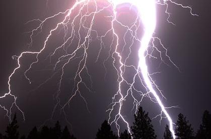
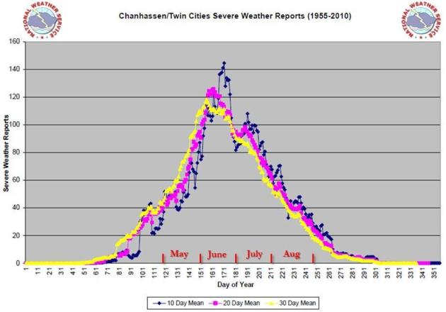
Extra-Severe Summer
Summer thunderstorms are a fixture across America. But this year has been unusually severe. According to the local NWS office, between July 14 & August 2 Minnesota was in a "slight risk" of severe weather 80% of the time, which (in their words) "is astounding." It was a summer of record dew points, 82 at MSP, 88 at Moorhead (new state record); a jungle-like dew point of 75+ nearly 100 hours.
All this extra moisture in the air can spark more severe storms capable of flash floods. A recent Environment America report examining 3,000 weather stations since 1948 found a 24% increase in extreme precipitation events nationwide; a 34% spike in Minnesota, a 61% increase in heavy rain (and winter snow) across New England. This summer put an exclamation point at the end of that report.
July was an amazing month: 2,755 record highs, 6,171 record (warm) lows. Never a dull moment.
Remarks Highlight Pawlenty's Climate Shift. An article at the Star Tribune: "Former Gov. Tim Pawlenty's position on climate change has now shifted from "one of the most important issues of our time" to questioning whether humans have had any effect on climate change at all. In a wide-ranging interview with the Miami Herald, Pawlenty said that "the weight of the evidence is that most of it, maybe all of it, is because of natural causes. But to the extent there is some element of human behavior causing some of it -- that's what the scientific debate is about." It wasn't too long ago that Pawlenty took a much more muscular approach to climate change. Shortly into his second term as governor, the Minnesota Republican made a big push for clean energy. When he was named chair of the National Governors Association, Pawlenty had the theme of "Securing a Clean Energy Future." He touted Minnesota legislation that set an ambitious goal of reducing greenhouse gas emissions 15 percent by 2015 and 80 percent by 2050. In 2007 he said he wanted the Upper Midwest to become "the Saudi Arabia of renewable energy." Pawlenty had teamed up with explorer Will Steger, planning a trip with him to the Arctic before he ultimately canceled. He joined with then-Arizona Gov. Janet Napolitano, a Democrat, in 2008 for an ad sponsored by the Environmental Defense Action Fund that pushed Congress to act on clean-energy standards. At one point, he called U.S. actions on energy "unsustainable" and, in calling for new carbon emission standards, said that "we have an unbelievable and unhealthy amount of our economy hooked to fossil fuels."
* The L.A. Times has another story about Mr. Pawlenty's recent remarks about "natural" climate change here.
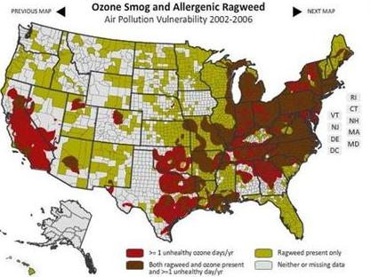
Climate Change Affects Each State, Web Tool Shows. The story at USA Today:
"How badly is climate change affecting your state? A new Web tool allows users to see how vulnerable their area has been to drought, flooding and heat extremes as well as the health problems that go along with them. This tool, based in part on weather data gathered by the National Climatic Data Center and developed by the Natural Resources Defense Council, compares each state's temperatures from 2000 through 2009 with those from 1961 to 1990. Users can see, for example, that the western United States has recently had more days of extreme heat than in previous decades."Climate change is real and in many cases is already affecting people and natural ecosystems," said Kim Knowlton, senior scientist at NRDC, a private environmental group. "From the dangers of extreme heat and increased flooding to the spread of ragweed whose pollen causes allergies or mosquitoes that can spread disease, climate change does not discriminate and local communities need to be better prepared."
Climate Change: Who Are The Skeptics? Nextgenjournal.com has the story; here's an excerpt: "As we discussed last time, there is a remarkable level of scientific consensus on the reality and severity of human-caused global warming. However, most members of the public are unaware of this consensus–a topic which we will focus on in the next installment. Anyone with an Internet connection or a newspaper subscription will be able to tell you that many scientists think global warming is natural or nonexistent. As we know, these scientists are in the vast minority, but they have enjoyed widespread media coverage. Let’s look at three of the most prominent skeptics, and examine what they’re saying. S. Fred Singer is an atmospheric physicist and retired environmental science professor. He has rarely published in scientific journals since the 1960s, but he is very visible in the media. In recent years, he has claimed that the Earth has been cooling since 1998 (in 2006), that the Earth is warming, but it is natural and unstoppable (in 2007), and that the warming is artificial and due to the urban heat island effect (in 2009). Richard Lindzen, also an atmospheric physicist, is far more active in the scientific community than Singer. However, most of his publications, including the prestigious IPCC report to which he contributed, conclude that climate change is real and caused by humans. He has published two papers stating that climate change is not serious: a 2001 paper hypothesizing that clouds would provide a negative feedback to cancel out global warming, and a 2009 paper claiming that climate sensitivity (the amount of warming caused by a doubling of carbon dioxide) was very low. Both of these ideas were rebutted by the academic community, and Lindzen’s methodology criticized. Lindzen has even publicly retracted his 2001 cloud claim. Therefore, in his academic life, Lindzen appears to be a mainstream climate scientist–contributing to assessment reports, abandoning theories that are disproved, and publishing work that affirms the theory of anthropogenic climate change."
* Image above courtesy of Flickr, Christine Zenino
When Climate Changes Come, And Water Policies Fail - Pray For Rain? Many Texans are turning to prayer right now - it's been the worst 1-year drought in Texas history, according to NOAA. Peter Gleick has a story about the heat/drought at Huffington Post: "Texans and the rest of the country are getting a preview of the future of water when national and local leadership on climate and water policies fail. Texas in the throes of its worst one-year drought on record according to the Texas State Climatologist Texas A&M Professor John Nielsen-Gammon. July was the warmest month ever recorded for Texas going back to 1895. July was the fifth consecutive month with extremely low precipitation totals, and it had the least year-to-date precipitation ever recorded. As Professor Nielson-Gammon stated, "Never before has so little rain been recorded prior to and during the primary growing season for crops, plants and warm-season grasses." And climate change is playing a role: "we do know is that temperatures are a degree or two warmer with climate change so the drought is worse than it would otherwise be," said Nielsen-Gammon." The official response of Governor Perry -- in the form of a proclamation -- was to declare official "Days of Prayer for Rain" in the State of Texas and to urge people to pray for rain. That was in April. It didn't work (at least from a hydrological point of view). This week, Governor Perry reissued the official drought disaster proclamation, but has provided few resources or specific directives to local governments and agencies for how to deal with the drought. The state will be looking for federal money for disaster relief and small business loans."

America's Gut Feeling About Climate Change. Here's an article from earthjustice.org: "When it comes to climate change, the fact is that most Americans don’t know the facts. A study by Yale professors revealed that while a majority (63 percent) of Americans believe in global warming, only half understand that it is anthropogenic (caused by human activity). And when the study tested the public on the science behind the warming, the results weren’t pretty. On a straight grading scale, more than half of the population surveyed scored an F. Over three-quarters scored either a D or an F. Even once a curve was applied to account for the greater difficulty of some questions, two-thirds still received a C or below. Not exactly cum laude. However, the study also revealed a surprise. Despite the clear lack of public knowledge concerning the science behind global warming, most Americans do have a firm understanding of ways they can reduce their carbon footprint:
· 75 percent knew that switching from fossil fuels to renewable energy, and driving electric cars instead of gas cars would decrease carbon emissions.
· 81 percent knew that planting trees would help.
· 73 percent knew that we should reduce tropical deforestation.
· 76 percent knew that we should drive less.
So the question becomes this: if Americans know the solutions, should it be concerning that they don’t understand the problem?"

In Defense Of Climate Science. Here's an excerpt of an Op-Ed in the Grand Junction Free Press: "When it comes to global warming and climate change the science is a proven fact, not a theory. Temperatures are on the rise and so are climate disruptions. Greenhouse gas emission concentrations are at their highest point in 800,000 years. There is no dispute in the world scientific community regarding either the existence of these phenomenon or their causes. Top scientists all agree that the climate change problem is enormous. As early as 2001, the Intergovernmental Panel on Climate Change (IPCC) determined that human activities were affecting global climate, calling the warming climate “unequivocal,” a conclusion ratified many times since from scientists around the globe. Yet, even with the conclusions of thousands of scientists from across the world representing many related disciplines firmly established, large numbers of the American public still believe that the issue is in dispute. Why, then, is denial so prevalent in the public sphere? One reason is because we have an erroneous view of science itself. We expect science to give us concrete proof and certainty. When it does not, we assume that something is wrong or incomplete. Science provides a consensus of experts based on accumulated knowledge, study and observation. The field provides the best evidence with facts and figures, in peer reviews by many other scientists, from wide ranging and interconnected fields of study. Then, only after undergoing in-depth and rigorous revision and review, are scientific findings published. We accept that science has brought us advanced technology, that medical science saves lives, and that we can send men to the moon. Science establishes the existence and interrelationships of microscopic worlds from under the oceans to distant planets. We trust and believe in science that reaches into our lives every day, yet refuse to believe the science of climate. You cannot have it both ways. Either you believe what science can deliver or you do not. One cannot select the science you choose to believe and discard the rest. That is not valid."

El Nino, La Nina, Climate Change, And The Horrific Drought In Somalia. How much of Africa's historic drought can be chalked up to "normal weather extremes" and what role (if any) does climate change play? The story from Time Magazine: "As I write this, Somalia is suffering its worst drought in 60 years. The lack of rain—combined with civil unrest and political interference from the al-Qaeda linked al-Shabab group—has produced catastrophic results. Yesterday Nancy Linborg, an official with the U.S. Agency for International Development (USAID), told a Congressional committee that more than 29,000 children under the age of 5 had died over the past three months in Somalia, thanks to the famine. If conditions worsen—and there's little reason to expected that they won't—upwards to 800,000 children may die of hunger and other causes. The violent political situation on the ground has multiplied the effect of the famine, preventing UN and other aid groups from helping the starving. But the drought itself is crippling—rainfall over the Horn of Africa, which includes Somalia, Ethiopia and Kenya in East Africa, between February and July 2011 has been 2 to 8 inches below normal, as a map (click here to see map and full text of the Time article) from the National Oceanic and Atmospheric Administration shows."