"...
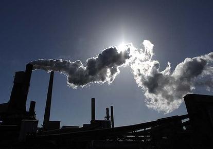
But the tsunami of hype on this story was relentless, a Category 5 performance that was driven in large measure by ratings. Every producer knew that to abandon the coverage even briefly—say, to cover the continued fighting in Libya—was to risk driving viewers elsewhere. Websites, too, were running dramatic headlines even as it became apparent that the storm wasn’t as powerful as advertised. The fact that New York, home to the nation’s top news outlets, was directly in the storm’s path clearly fed this story-on-steroids. Does anyone seriously believe the hurricane would have drawn the same level of coverage if it had been bearing down on, say, Fort Lauderdale? " - article on the media hyping of Hurricane Irene in the Daily Beast below.
*
photo credit above:
Richmond Times Dispatch.
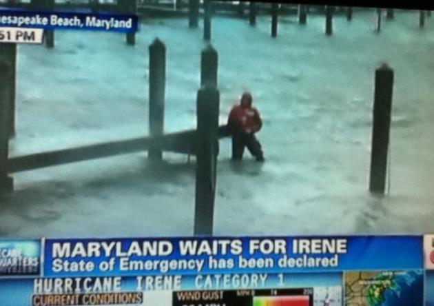
Not to, in any way, minimize the impact of at least 21 storm-related deaths in 6 states....or extensive inland flooding, especially over Vermont, Irene was an underwhelming hurricane for much of the northeastern USA. The massive storm surge that some media outlets were warning off Friday never came to pass. Irene came ashore over northern New Jersey early Sunday as a minimal Category 1 hurricane, weakened considerably after passing over North Carolina on Saturday. In addition, dry air wrapped into the storm, and wind shear aloft shredded the circulation - warm Gulf Stream water off the coast of Virginia and New Jersey wasn't enough to strengthen the storm as it accelerated northward. Irene moved faster than expected, pushing north across New York City at 25 mph Sunday morning. The storm surge was 4 to 4.5 feet in New York Harbor, submerging some streets in Lower Manhattan, including the FDR - closing one tube of the Holland Tunnel for a few hours. Irene arrived during high astronomical tide (8 am Sunday), which compounded the surge. But some of the more extreme predictions (8-12 foot storm surge for New York City?) were wildly inflated, and borderline irresponsible. My big concern: a growing risk of APATHY. New Yorkers (and New England residents in general) may react with a "so what?" reaction the next time a truly dangerous hurricane threatens the east coast. The truth: we've experienced winter nor'easters that were more damaging than this hurricane. A few more statistics related to Irene:
*
wettest month on record for Philadelphia and New York City with over 19" of rain reported.
*
peak storm surge in New York Harbor: 4.5 feet at 9 am Sunday morning.
*
60 mph wind gust in New York as Irene passed almost directly overhead.
*
FDR Drive had to close due to storm surge flooding; the north tube of the Holland Tunnel flooded as well.
* "
several billion dollars" in estimated damage along the Jersey shore, according to New Jersey Governor Chris Christie.
*
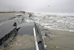
Highway 12 on the Outer Banks was cut off by the storm surge in at least 5 separate spots.
*
Over 4.5 million Americans lost power over the weekend, due to Hurricane Irene.
*
Statewide disaster for Vermont. Flooding may some of the worst in Vermont's history.
** Irene moved north faster than the models predicted, taking a more westerly path than the (majority) of NHC models were predicting as recently as Saturday morning.
Inland flooding was probably underpredicted (in retrospect), while the coastal storm surge was (in 20/20 hindsight) exaggerated. NHC models did a good job with the storm surge forecast, but many of the national cable networks were warning viewers of a worst-case scenario, a possibly storm surge of 8-12 feet in New York Harbor. The actual storm surge peaked at 4.5 feet at 9 am Sunday morning in NYC.
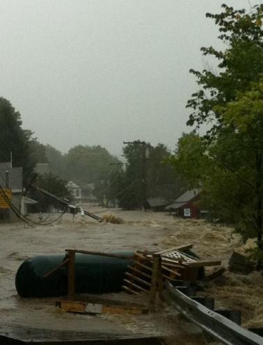 Severe Flooding In Wilmington, Vermont.
 The soggy remains of Irene may have dumped as much as 6-8" rain on Vermont, resulting in extreme flooding. The ground was already saturated from an unusually wet summer - the rain from Tropical Storm Irene almost immediately ran off into streets and streams. Photo courtesy of
yfrog.com.
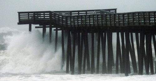
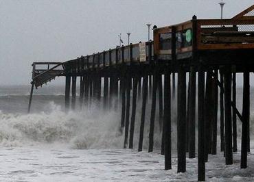
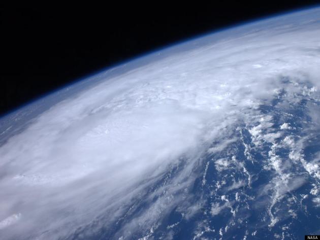
Landfall. "
Waves crash onto a road as Hurricane Irene arrives on August 28, 2011 in Southampton, New York." (Joe Raedle - GETTY IMAGES) . Courtesy of the
Washington Post.
New Jersey Governor Christie Expects Damage "In The Billions". Here's an update from
Yahoo News and Reuters: "
WASHINGTON (Reuters) - New Jersey Gov. Chris Christie said on Sunday that he expects damages from Hurricane Irene to run into the billions of dollars along the state's Atlantic coast and from inland river flooding. "I've got to imagine that the damage estimates are going to be in the billions of dollars, if not in the tens of billions of dollars," Christie said in an interview with NBC's "Meet the Press" program."
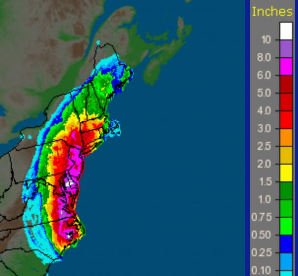 Rainfall From Irene
.
NOAA Doppler estimates show a band of 6-10" from eastern North Carolina northward to New Jersey.
Here are the highest rainfall totals per state from Irene from NOAA's HPC division:
15.74" Bayboro, NC
13.30" East Durham, NY
12.96" Plum Point 3 WSW, MD
11.04" Freehold Township 1 WNW, NJ
11.04" Suffolk Airport, VA
10.42" Ellendale, DE
8.90" Savoy, MA
8.82" Lafayette, PA
8.44" Winsted 0.7 SE, CT
7.00" Hinsdale, NH
5.93" Brattleboro 2 SW, VT
5.37" Warren, RI
4.75" Bethel, ME
3.62" Myrtle Beach 8.6 SW, SC
3.36" Reagan National Airport, DC
Can Hurricane Irene Batter Republicans Into A U-Turn On NOAA Cuts? A 30% cut in NOAA's budget? That sounds like a really good idea, considering 2011 is rapidly turning into the most severe year on record for the nation. Cutting & slashing NOAA's budget sounds like a prudent course of action, right? The U.K.
Guardian has the story: "
Now might be a good time for Republicans to rethink their proposal to cut 30% from the existing budget of the National Oceanic and Atmospheric Administration (NOAA) – the agency responsible for tracking hurricanes. NOAA says the Republican cuts will destroy its ability to warn of hurricanes five or 10 days out. That is crucial lead time to carry out the preparations and evacuations we have been seeing this weekend with Hurricane Irene. Mississippi floods, the mid-Atlantic tornados, south-western wildfires and record heatwaves made 2011 a year of extreme weather events well before Irene hit. But Republicans in the House of Representatives insist NOAA is a waste of money."
Death Toll From Irene Reaches 15. More storm details from AP and
WTOP-AM:
CONNECTICUT:
_ In Prospect, one person was killed in a fire that Gov. Dannel P. Malloy said apparently was caused by wires knocked down by the storm.
FLORIDA:
_ In Volusia County, 55-year-old Frederick Fernandez died Saturday off New Smyrna Beach after he was tossed off his board by massive waves caused by Irene. The Orlando Sentinel reports the high school teacher had a large cut on his head, apparently from hitting the sea floor. He was pronounced dead shortly after being pulled from the water.
_ In Flagler County, 55-year-old tourist James Palmer of New Jersey died Saturday in rough surf. Family members say they lost sight of him after he waded into the surf in North Florida. He was pulled to shore and his wife attempted CPR, but he was pronounced dead at the hospital.
MARYLAND:
_ In Queen Anne's County, a woman was killed when a tree fell on a house and caused the chimney to collapse. Another person in the house was not hurt.
NORTH CAROLINA:
_ In Nash County, a man was killed after a tree limb fell on him outside his home Saturday morning as outer bands from the storm brought near hurricane-force gusts inland.
_ Goldsboro police say a 15-year-old girl died Saturday afternoon after the SUV carrying her and family members collided with another SUV at an intersection where Irene had knocked out power to traffic lights. The victim and other family members were thrown from their SUV, and occupants of both vehicles were taken to the hospital. The girl's family was returning to northern Virginia from a vacation in Myrtle Beach, S.C.
_ A man in Pitt County drove through standing water, went off a road and died after striking a tree on Saturday.
_ A mother in Sampson County died Saturday morning when a tree fell on a car carrying her and two family members.
VIRGINIA:
_ Newport News authorities report that 11-year-old Zahir Robinson was killed when a large tree crashed through his apartment shortly after noon. He was pronounced dead at the scene. The boy's mother, who was in the apartment, was not injured.
_ In Brunswick County, a tree fell across a car Saturday afternoon, killing 67-year-old James Blackwell of Brodnax. The driver was taken to the hospital with minor injuries.
_ Chesterfield County police say a man died at a Hopewell hospital Saturday after a tree fell on a house that he was inside with six other adults. A woman in the house was hospitalized with non-life-threatening injuries.
Get Real: Hurricane Irene Should Be Renamed "Hurricane Hype". I have to at least partially agree with
Forbes on this one. Forecasters underestimated the inland flooding, while overestimating the impact of the storm surge, especially on New York City and Boston: "
Over the years the National Hurricane Center (NHC) has employed the world’s best experts on Atlantic tropical cyclones, from “Dr. Bob” Simpson, to the mediagenic Neil Frank and on to the current director, Bill Read. The lifesaver-in-chief was probably Frank, who indefatigably crisscrossed the nation educating the public to the dangers—hidden and obvious—that accompany these curiously seductive weather systems. His era was one of many innovations, including extensive use of satellites, and tailoring the “names” of storms to the culture where they roam in order to attract attention.....The number of false positives has so cheapened the currency of tornado warnings that few now bother to interrupt their work when one is given. While the very good forecasters at the National Weather Service were not at all happy when veteran TV meteorologist James Spann blamed a large number of Tuscaloosa deaths on the very high false alarm rates, he had a point."
A Hurricane Of Hype. Thanks for ripping off my newspaper headline, Howard. I didn't see any credit from
The Daily Beast's Howard Kurtz, who is complaining about the Armageddon-like drumbeat coming from the national media leading up to Irene's arrival. More of a whimper than a bang: "
It was raining in Manhattan on Sunday morning, and the dogged correspondents in their brightly colored windbreakers were getting wet. But the apocalypse that cable television had been trumpeting had failed to materialize. And at 9 a.m., you could almost hear the air come out of the media’s hot-air balloon of constant coverage when Hurricane Irene was downgraded to a tropical storm. Not everyone was willing to accept this turn of events. When the Weather Channel’s Brian Norcross told MSNBC that forecasters had been expecting the first hurricane to make landfall in New York City since 1893—“and it didn’t happen”—anchor Alex Witt was openly skeptical. “Really, Brian?” she asked. Hadn’t Irene technically still been a hurricane when it came ashore in New York an hour earlier? “Can’t we still go with that?” No, Norcross said."
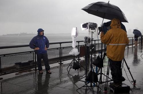
photo credit above: "
Meteorologist Jim Cantore, left, and a crew from The Weather Channel, report on Hurricane Irene from Battery Park in New York City on August 27, 2011, Jonathan Saruk, The Weather Channel / Getty Images."
FEMA's Budget Disaster. What a year. Irene will probably go down in the record books as the 10th billion-dollar-plus weather disaster in 2011, which would be a new record (old record is 9 separate billion dollar disasters in 2008). The
Daily Beast reports on how the endless treadmill of tornadoes, floods, heatwaves, droughts (and now hurricanes) are impacting FEMA's budget: "
It’s been a busy year for America’s disaster agency, and that may soon spell disaster for its budget. It started with severe winter storms in the east and southwest in January. Tsunami waves from the Japanese earthquake struck the West Coast and Hawaii in March, followed by the tornado that flattened parts of southern Missouri in May. Several Midwest states saw flooding earlier this month. And an earthquake and hurricane rocked the East Coast this week. So far in 2011, the Federal Emergency Management Agency (FEMA) has responded to “major disasters” 65 times, among the highest in the agency’s history. The unprecedented demand has stretched the agency and its budget increasingly thin. Craig Fugate, FEMA’s administrator, told White House reporters in May that the agency’s disaster relief fund was running low, then just above $1 billion. Without an infusion from Congress, he said, relief workers would only address immediate needs, like delivering food and water, instead of less immediate concerns like clearing felled trees and cleaning streets."
Challenges In Predicting The Intensity Of Storms. Weather models do a fairly good job predicting the track of hurricanes, but the intensity of these massive storms is more of a wild-card, in spite of supercomputer technology and realtime data from "Hurricane Hunter" aircraft flying into these storms. The
New York Times details the challenges of predicting hurricane intensity: "
Irene may be the first hurricane to hit the East Coast in several years, but in one respect it is like all the others that have come and gone before it: forecasters have had difficulty predicting its strength. Officials with the National Hurricane Center warned Saturday that the storm was still capable of inflicting heavy damage, particularly from flooding, as it slogged toward New Jersey and New York. But they said it had decreased in intensity, with sustained wind speeds of about 80 miles an hour, down 15 miles an hour from 12 hours before. And they acknowledged that they did not know precisely why it had weakened. “There’s some internal dynamics of the storm that we don’t completely understand,” said Todd Kimberlain, a hurricane specialist at the center in Miami. Mr. Kimberlain said one reason for the weakening may be that the storm had never completed a typical hurricane cycle in which the innermost band of spinning clouds, called the inner eye wall, dissipates and is replaced with an outer band that contracts."
* photo credit above: Andy Newman, AP.
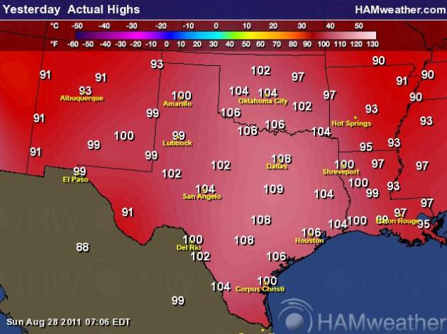 Record Heat Continues In Texas
. Saturday's high in Houston was a blazing 109 F, tying the record for the hottest temperature ever recorded. Map courtesy of Ham Weather.
Darwin Award Goes To CNN. Are they trying to drown this poor reporter? At the same time they're urging viewers to seek shelter and "head to higher ground" - news crews are on the beach, in the water, almost tempting Mother Nature. Yes, this storm was over-hyped. Any hurricane is a big deal, but you would have thought we were tracking Armageddon. What got lost in the effort to boost ratings was perspective, a cool, calm, rational analysis of Irene. No, the national media did not do a good job with this hurricane. Who cares? My biggest fear: when the "Big One" does come up the coast people may be ambivalent; apathy may set in "hey, they hyped the last storm and it wasn't that bad...why listen to them now?" That's my biggest concern.
Breaking News. No Hurricanes, but a kitten was born at the Miracle of Birth Center (Minnesota State Fair):
PUBLIC INFORMATION STATEMENT
NATIONAL WEATHER SERVICE TWIN CITIES/CHANHASSEN MN
210 PM CDT SAT AUG 27 2011

...MINNESOTA STATE FAIR...

AT 2 PM...AT THE MINNESOTA STATE FAIR...IN THE MIRACLE OF BIRTH
CENTER...A TEMPERATURE OF 79 DEGREES WAS REPORTED UNDER MOSTLY
CLOUDY SKIES. BY THE WAY...A KITTEN WAS BORN AT THE BIRTH CENTER
EARLIER TODAY.
PUBLIC INFORMATION STATEMENT
NATIONAL WEATHER SERVICE GREEN BAY WI
1145 AM CDT SAT AUG 27 2011

...ACTIVE TORNADO SEASON IN NORTHEAST WISCONSIN...

THROUGH AUGUST 27...14 TORNADOES HAVE BEEN CONFIRMED THIS YEAR IN THE
NWS GREEN BAY SERVICE AREA OF NORTHEAST WISCONSIN.  THIS IS ABOUT TWICE
THE LONG-TERM AVERAGE FOR THE AREA.  ON APRIL 10 ALONE...TEN TORNADOES
OCCURRED IN NORTHEAST WISCONSIN...A SINGLE DAY RECORD TORNADO OUTBREAK
FOR THE AREA.

IN WISCONSIN...36 TORNADOES HAVE BEEN DOCUMENTED SO FAR THIS YEAR.
THE 30-YEAR AVERAGE IS 23 FOR AN ENTIRE YEAR.

BELOW IS A PRELIMINARY LIST OF TORNADOES REPORTED IN THE NWS GREEN BAY
SERVICE AREA IN 2011.

DATE     LOCATION (COUNTIES)        MAGNITUDE   PATH (MILES)
---------------------------------------------------------------------
APR 10   MARATHON-LINCOLN             EF3         21.2
APR 10   WAUSHARA                     EF1         10.9
APR 10   LANGLADE                     EF1          5.3
APR 10   WAUSHARA-WAUPACA-OUTAGAMIE   EF1         27.7
APR 10   FOREST-FLORENCE              EF2         12.0
APR 10   WAUSHARA-WINNEBAGO           EF1         14.9
APR 10   FOREST                       EF1          3.3
APR 10   OUTAGAMIE                    EF2          1.5
APR 10   BROWN                        EF1          1.2
APR 10   CALUMET                      EF1          1.7
MAY 22   WOOD-PORTAGE                 EF1         31.6
AUG 19   MARINETTE                    EF1          7.8
AUG 23   SHAWANO                      EF0          0.2
AUG 23   CALUMET                      EF0          0.5

NOTES:
1. THE MAY 22 TORNADO MOVED OUT OF JUNEAU COUNTY IN THE NWS LA CROSSE
SERVICE AREA.  ENTIRE PATH LENGTH OF THE TWISTER WAS JUST OVER 64 MILES.
2. THE AUG 19 TORNADO BRIEFLY PASSED INTO UPPER MICHGAN ALONG THE
MENOMINEE RIVER BEFORE MOVING BACK INTO MARINETTE CO.
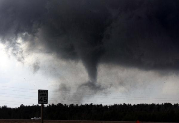
* Photo credit of tornado:
ouramazingplanet.com.
Science Uncertain How Wildlife Deals With Severe Weather. Here's an interesting story from the
Pittsburgh Post Gazette: "
Many animals seem to sense when bad weather approaches. They become restless, often abandon their normal activities, and sometimes flee the area. I suspect many can detect subtle changes in barometric pressure that precede approaching storms. Cavity-nesting birds and mammals no doubt ride out storms in tree cavities. As long as the tree doesn't snap, they're fine. If a tree beaks off at the cavity, the occupants may get waterlogged and succumb to hypothermia. In the case of flash floods, burrow dwelling animals may seem doomed. But most mammal burrows are not simply holes in the ground. Often these animals burrow down and then turn the burrow upward before excavating their living quarters. This makes it less likely that floods completely wash out burrow systems. During prolonged, extended floods, however, all bets are off, and many burrow dwellers probably die."
*
photo credit above:
refugeassociation.org.
What Hurricane Preparedeness Looks Like In New York City. Here's a tongue in cheek blurb from
happyplace.com: "
America, please pray for New York. Pray that the destruction isn't so great that the wifi goes out, preventing New Yorkers from constantly uploading their iPhone photos of said destruction. Pray that the television coverage is so myopically focused on New York's brunt of the storm that its citizens don't have to be bored with brief reminders of the other dozen states being drowned by Irene's wrath. And please, for the love of God, pray that the storm will hold off long enough to not put a damper on Sunday brunch plans. Amen. Let us know in the comments what you think may be missing from this list."
Tenacity. This restaurant in Wilmington, North Carolina, wasn't going to let a "little hurricane" get in the way of serving up world-famous oysters! Photo courtesy of
happyplace.com.
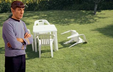
Spock. Apparently he wasn't all that impressed with last week's tremor in Virginia. A lawn chair was knocked over. OMG!
 Remembering 9-11.
 This has nothing to do with weather (obviously), but you don't want to miss a special series of documentaries on the
National Geographic Channel all this week. Last night's first-person account from President George W. Bush was extraordinary - tonight's special looks at 9-11 through the eyes of former New York City Mayor Rudy Giuliani.
Why Weather?
"You're a WEATHERMAN!" KARE-TV anchor Paul Magers told me with a smirk (late 1980s?) I don't think it was a compliment. Why subject myself to daily humiliation?
I'm still in awe of the weather. Predicting the weather is an intellectual challenge. Weather models are great, but the most accurate forecasts rely on man & machine. Perspective is critical. We get to tell stories every day, and the "toys" we play with are incredible: Doppler, supercomputers & weather satellites. It's a humbling profession - we're still learning.
For example, hurricanes go thru cycles; the "eye-wall" regenerates - a new eye forms, replacing the original eye, which makes the prediction of hurricane intensity even more challenging. And yes, "It's the only job where you can be wrong much of the time and still get paid!"
Ha ha.
Clean-up from over-hyped Hurricane Irene (at least in terms of storm surge predictions for major cities, including New York City) is underway. A long-range European model prints out another hurricane over New York on 9/11. Hope it's wrong.
Climate Stories...
Climate Change Has Made New Yorkers More Vulnerable To Hurricanes. Here's a story from
Grist Magazine and Climate Central: "
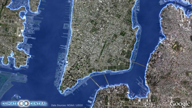
Hurricanes inflict some of their greatest damage by pushing walls of water onto land, in what are called storm surges. The National Oceanic and Atmospheric Administration (NOAA) estimates that Hurricane Irene may generate peak surges of up to 10 feet high in places along the Mid-Atlantic coast. Tall wave action will compound the threat in exposed areas. And over the last century, mostly due to global warming, sea level has risen about a foot along much of the coast, placing even more people and homes at risk than would have otherwise been the case. This map below shows lower Manhattan and parts of Brooklyn and New Jersey. The blue area identifies the land zone within five vertical feet of the average high tide line, toward the upper end of the range of surge heights NOAA is predicting for the immediate area. Based on 2010 Census information and Climate Central's map analysis, almost a quarter million (233,000) people live in this zone for all of New York City. That's 28 percent (65,000 people) more than live within the four-foot zone -- the line we would be talking about if the sea hadn’t risen a foot over the last hundred years. About two-thirds of that rise appears to come from global warming."
Hurricane Irene, Global Warming, And The Rising Cost Of Storm Surge Damage. Here's the story from
thedailygreen.com: "
When the words "hurricane" and "global warming" end up in the same sentence in a news story, typically the subject is whether climate change is or will make Atlantic hurricanes stronger or more frequent. Unlike many other aspects of climate change, that's one point where legitimate scientists argue, and the jury is still out. But when it comes to the damage that hurricanes are likely to do when they make landfall in the U.S., there's considerably less debate. For one, more people live along the coasts than ever, and people continue to move there despite the ongoing seasonal risk of tropical storms and hurricanes. As of 2003, more than half of the U.S. population lived along the coast, and the 153 million people living there at that time had grown nearly 30% in 25 years, according to a 2008 National Oceanographic and Atmospheric Administration study. Since 2003, the U.S. experienced the real estate bubble and a building boom, adding substantially to the homes in hurricane risk zones."
Seeing Irene As A Harbinger Of Climate Change. I think we have to be very careful about linking any one storm with climate change. As one climate scientist described Irene to me: "Irene didn't start the fire, but a warmer ocean may have thrown another log on the fire." The number of Category 4-5 hurricanes has nearly doubled since 1970. There's no evidence that a warming atmosphere (and warmer ocean water) is producing more hurricanes, but there may be a link betwen climate change and the intensity of some of these massive, Texas-size storms. More from the
New York Times:
"
The scale of Hurricane Irene, which could cause more extensive damage along the Eastern Seaboard than any storm in decades, is reviving an old question: are hurricanes getting worse because of human-induced climate change? The short answer from scientists is that they are still trying to figure it out. But many of them do believe that hurricanes will get more intense as the planet warms, and they see large hurricanes like Irene as a harbinger. While the number of the most intense storms has clearly been rising since the 1970s, researchers have come to differing conclusions about whether that increase can be attributed to human activities. “On a longer time scale, I think — but not all of my colleagues agree — that the evidence for a connection between Atlantic hurricanes and global climate change is fairly compelling,” said Kerry Emanuel, an expert on the issue at the Massachusetts Institute of Technology. Among those who disagree is Thomas R. Knutson, a federal researcher at the government’s Geophysical Fluid Dynamics Laboratory in Princeton, N.J. The rising trend of recent decades occurred over too short a period to be sure it was not a consequence of natural variability, he said, and statistics from earlier years are not reliable enough to draw firm conclusions about any long-term trend in hurricane intensities."
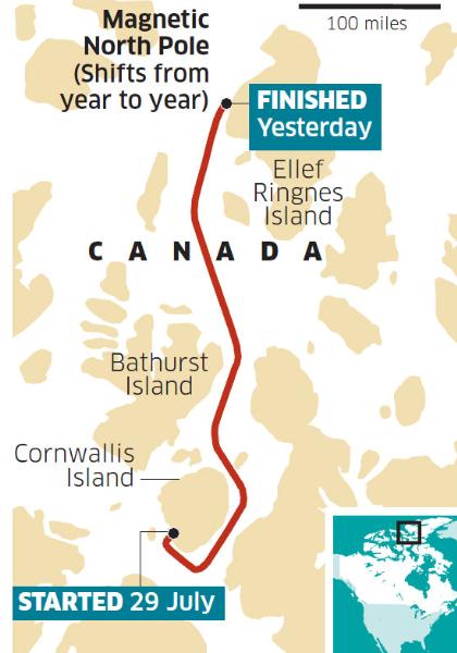
Rowing a boat to the North Pole? I didn't think that was even possible, in spite of thinning Arctic ice. Here's the story from the U.K.
Independent newspaper: "
Six British adventurers were "on top of the world" yesterday after they became the first team to row to the magnetic North Pole. They were exhausted by their 28-day journey but were jubilant to have set a record they had been told was impossible. They rowed 450 miles from Resolution Bay in Canada, but found the last three miles so badly congested by ice floes and lumps of broken ice that they had to drag the rowing boat for several hours to complete the last stretch of the journey. Jock Wishart, who has previously set records rowing across the Atlantic, said the scale of their achievement had "yet to sink in". But he confessed to leaping about on the ice in excitement when it was confirmed that they had reached the pole. As expedition leader, he was tossed from an ice floe into the Arctic water as the team celebrated the end of their journey yesterday."
NSF Confirms Results Of Penn State Investigation; Exonerates Michael Mann Of Research Misconduct. An update from
scholarsandrogues.com: "
As a result of the illegal publication of CRU climate emails, the Pennsylvania State University (PSU) conducted an inquiry and investigation into allegations of research misconduct by Professor Michael Mann. The University exonerated Mann of all four allegations in July 2010, but the National Science Foundation Office of Inspector General (OIG) reviews such investigations for completeness and correctness. On August 15, 2011, the OIG released the results of their own review, agreeing with all of the conclusions of the PSU investigation and subsequently acquitting Mann of all the allegations of research misconduct made against him. PSU published the results of an their internal investigation into alleged research misconduct by climatologist Michael Mann on July 1, 2010. As S&R reported, the university’s conclusions were that Mann did not falsify data over the course of his research, that he did not destroy any emails in possible breach of the Freedom of Information Act, that he did not misuse his position or abuse confidentiality agreements, and that he did not deviate from accepted practices of conduct for his field."
The Upside To Global Warming. The
Daily Beast ponders the advantages of a warming world: "
A few thousand years ago, a mighty river flowed through the Sahara across what is today Sudan. The Wadi Howar—now just a dried-out riverbed for most of the year—sustained not just fish, crocodiles, and hippopotamuses, but also agriculture and human settlement. As late as 1,000 B.C., a powerful fortress stood on its shores. But then the Sahara dried out, turning from a green savannah into an inhospitable desert. The culprit: climate change. According to desert geologist Stefan Kröpelin, who has studied geological data for the eastern Sahara going back 6,000 years, the desert spread as temperatures dropped. Global cooling meant that the air had less capacity to hold moisture from the oceans, leading to fewer rains and more arid climes."
Mental Illness Rise Linked To Climate. In what is sure to be a controversial link - here's the story from Australia's
Sydney Morning Herald: "
RATES of mental illnesses including depression and post-traumatic stress will increase as a result of climate change, a report to be released today says. The paper, prepared for the Climate Institute, says loss of social cohesion in the wake of severe weather events related to climate change could be linked to increased rates of anxiety, depression, post-traumatic stress and substance abuse. As many as one in five people reported ''emotional injury, stress and despair'' in the wake of these events. The report, A Climate of Suffering: The Real Cost of Living with Inaction on Climate Change, called the past 15 years a ''preview of life under unrestrained global warming''. ''While cyclones, drought, bushfires and floods are all a normal part of Australian life, there is no doubt our climate is changing,'' the report says. ''For instance, the intensity and frequency of bushfires is greater. This is a 'new normal', for which the past provides little guidance."
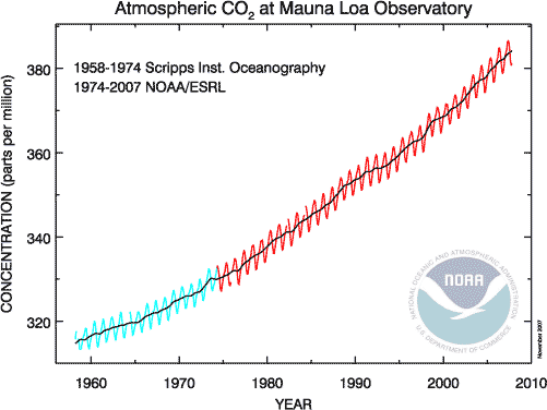
15 Irrefutable Signs That Climate Change Is Real.
Businessinsider.com has the story: "
From rising air and ocean temperatures to shrinking glaciers and widespread melting of snow and ice, evidence of a changing global climate is all around us. The Intergovernmental Panel on Climate Change has linked many of these changes in climate to an increase greenhouse gas emissions from human activities, which was documented in a 2007 assessment report compiled by thousands of scientists over decades of research and debate. Regardless of their causes – whether you believe in anthropogenic drivers, like fossil fuels from power plants and cars or not — the observed changes in climate are scientific facts that have grave implications for the future of natural and human systems. Click here to see the facts.
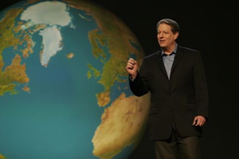
Al Gores Compares Climate Change Skepticism To Racism. This is why so many people have a problem with Al Gore. I respect the man for his passion, and trying to educate consumers about the perils of climate change (he's taken a lot of heat over the years), but when he compares climate change to racism I fear he's turning a lot of people off - that's a bit of a stretch in my humble estimation.
Slate.com has more details on his latest rant: "
Just as an unusually large Hurricane Irene bore down on the East Coast, Al Gore upped the ante in the global warming debate. In an interview with FearLess Revolution founder Alex Bogusky on Friday, Gore tackled topics like eating less meat, the challenges of industrial agriculture, and the dubious nature of mountaintop mining. But as Politico reports, he also offered up some advice to environmentalists when engaging in debate with climate change skeptics. Gore said that those who believed the issue was a serious one needed to “win the conversation” by directly challenging nay-sayers, just as civil rights activists did in the face of racism. Gore’s comment: “There came a time when people said, ‘Hey man, why do you talk that way? That’s wrong, I don’t go for that so don’t talk that way around me. I just don’t believe that.’ That happened in millions of conversations, and slowly the conversation was won. And we still have racism, God knows, but it’s so different now and so much better. And we have to win the conversation on climate.”