
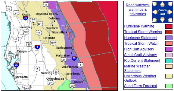
Florida: Tropical Storm Watches & Warnings. Warnings are in effect just 20 miles offshore - the biggest concern: rough surf and rip tides along the eastern coastline of Florida. Details from the National Weather Service here.
Potentially Bad News For The Coastal Mid Atlantic States & New England. Here's what we know: Florida will be spared, so will coastal Georgia and South Carolina. The Outer Banks will probably experience Category 2 or 3 force winds late Saturday into Sunday morning with a storm surge in excess of 4-5 feet on some of the barrier islands. An approaching trough of low pressure may pull the track a bit farther to the west after Irene passes North Carolina, meaning a potential for Hurricane Irene to create major damage from coastal Delaware and New Jersey to Long Island and southern New England. New York City may even experience hurricane conditions Sunday and Sunday night. A worst-case scenario is a track south/west of Manhattan, which could force water into Hudson Bay and flood much of Lower Manhattan. This appears unlikely, but we can't underestimate the potential for serious coastal flooding (and flash flooding inland, with some 10"+ rainfall amounts). Here's more on the uncertainty for Day 4-5 from NHC:
THE EYE OF THE HURRICANE HAS BEEN MOVING NEAR OR OVER SOME OF THE
BAHAMAS RESULTING IS SOME WOBBLING. THE BEST ESTIMATE OF THE
INITIAL MOTION IS TOWARD THE NORTHWEST OR 310 DEGREES AT 10 KNOTS.
THE DEVELOPMENT OF THE LARGE TROUGH ALONG THE EAST COAST OF THE
UNITED STATES IS MATERIALIZING AS PREDICTED BY THE GLOBAL MODELS.
THIS STEERING PATTERN WILL FORCE IRENE TO TURN TOWARD THE
NORTH-NORTHWEST AND THE NORTH WITH A SLIGHT INCREASE IN FORWARD
SPEED OVER THE NEXT FEW DAYS. THE LATEST GUIDANCE HAS CHANGED VERY
LITTLE...AND PERHAPS THE ONLY DIFFERENCE IS THAT THE GFS SHIFTED 30
N MI TO THE WEST...TOWARD THE ECMWF SOLUTION DURING THE LAST
PORTION OF THE FORECAST. THIS DOES NOT RESULT IN A SIGNIFICANT
CHANGE OF THE OFFICIAL FORECAST TRACK FROM THE PREVIOUS ONE.

BECAUSE IRENE IS A LARGE CYCLONE...TROPICAL STORM AND HURRICANE
WATCHES WILL LIKELY BE REQUIRED FOR A PORTION OF THE COAST OF THE
CAROLINAS EARLY THURSDAY.


FORECAST POSITIONS AND MAX WINDS

INIT  25/0300Z 23.8N  75.4W  105 KT 120 MPH
 12H  25/1200Z 25.5N  76.5W  110 KT 125 MPH
 24H  26/0000Z 27.5N  77.3W  115 KT 135 MPH
 36H  26/1200Z 29.5N  77.4W  110 KT 125 MPH
 48H  27/0000Z 31.5N  77.0W  105 KT 120 MPH
 72H  28/0000Z 36.0N  75.2W   90 KT 105 MPH
 96H  29/0000Z 42.5N  72.0W   75 KT  85 MPH
120H  30/0000Z 50.0N  67.0W   45 KT  50 MPH...POST-TROP/EXTRATROP
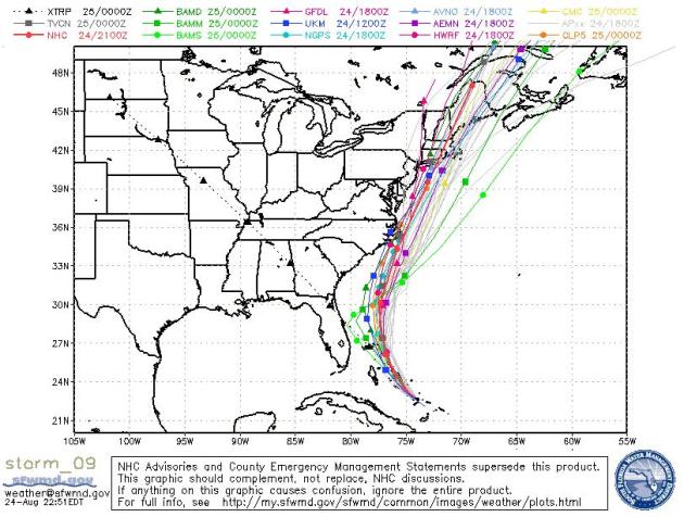
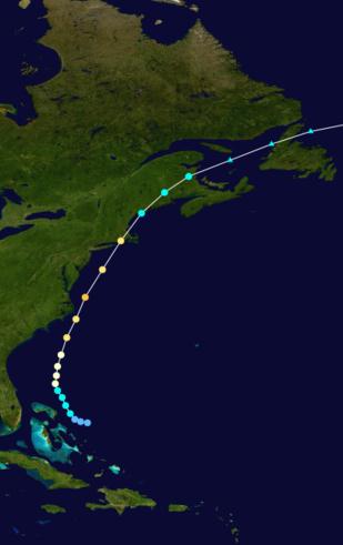
A Widening "Cone of Uncertainty". Confidence is high that Irene will make a turn to the north, and then north-northeast, but after Saturday the track is very uncertain, the "cone of uncertainty" increases. It's worth repeating that the average margin of error for landfall for Day 4 is plus or minus 200 miles in either direction.
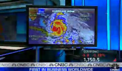
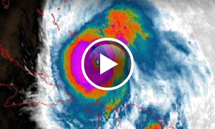
Can New York City Take A Category 5 Hit? The short answer is no. A Category 2-3 storm would be bad enough, capable of flooding much of Lower Manhattan, even flooding the subway system. 100 mph plus winds could shatter windows, creating a deadly shower of glass on the streets below. In a worst-case scenario Manhattan (island) could be completely cut off from the surrounding Tri-State area. CNBC has more: "There she is, folks. that's a live radar loop of hurricane erenal. you can see there's a good chance this is going to slam the northeast, including new york city. i don't do a lot of weather, but i can read a map. this is the expected pattern, extreme catastrophic, low, medium, high. multiple threat zones. we know it's coming. the question is how big and how much damage will it do? i want to show you something else, new video from -- we don't have a lot of reports of injuries yesterday, safe to say there will be problems reported when it's all said and done. in the meantime. noaa has sent its planes over the storm, and this is the latest video from the noaa. with the threat level for the northeast corridor, that was upgraded. now they're saying it's quite real. professor scott mandia is here with us. thanks for having me. working in the news, okay, we get crushed all the time for hyperbole and overstating concern. that's a common criticism, maybe some of it is deserved, all right? but talk to us about this storch. everybody that we have talked to said, listen, brian, it's not some hyped up story. how major is it? it's category 3, a katrina size storm, and should be category 4 by tomorrow morning."
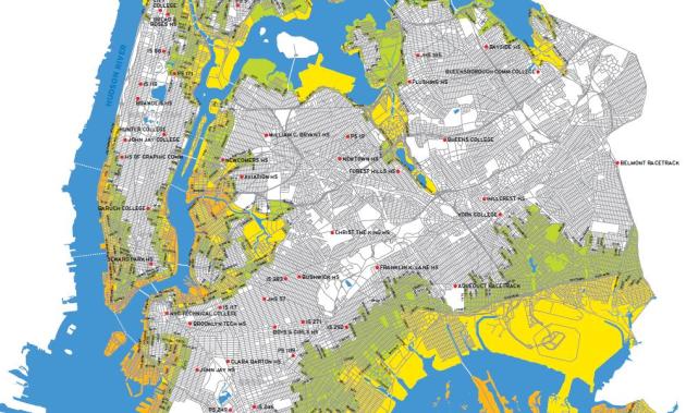
Most Vulnerable Boroughs Of New York City. If Hurricane Irene pushes a significant storm surge into coastal New Jersey and Long Island, flooding in New York City may be considerable. Here is a pdf document showing the most vulnerable regions of metro New York.
* Storm Surge is the biggest killer in a hurricane, not the high winds or embedded tornadoes. The combination of unusually low pressure and relentless winds can carve out a "dome" of water, as much as 10-20 feet above normal tide levels, pushed ashore ahead of the eye of a hurricane. The most dangerous quadrant is the northeastern sector of a hurricane, where the storm surge tends to reach its maximum value. Here are some facts about storm surge from NHC:
- From 1990-2008, population density increased by 32% in Gulf coastal counties, 17% in Atlantic coastal counties, and 16% in Hawaii (U.S. Census Bureau 2010).
- Much of the United States' densely populated Atlantic and Gulf Coast coastlines lie less than 10 feet above mean sea level.
- Over half of the Nation's economic productivity is located within coastal zones.
- 72% of ports, 27% of major roads, and 9% of rail lines within the Gulf Coast region are at or below 4 ft elevation (CCSP, SAP 4-7).
- A storm surge of 23 ft has the ability to inundate 67% of interstates, 57% of arterials, almost half of rail miles, 29 airports, and virtually all ports in the Gulf Coast area (CCSP SAP 4-7)
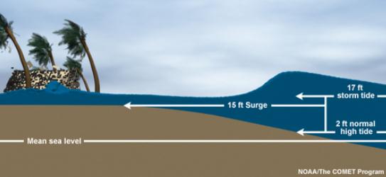
What Is Storm Surge? This is going to be the biggest concern, from the Outer Banks of North Carolina northward to coastal New Jersey, Long Island and southern New England - with the worst conditions to the east/right of Irene's track. Here'a good explanation from NHC: "Storm surge is an abnormal rise of water generated by a storm, over and above the predicted astronomical tides. Storm surge should not be confused with storm tide, which is defined as the water level rise due to the combination of storm surge and the astronomical tide. This rise in water level can cause extreme flooding in coastal areas particularly when storm surge coincides with normal high tide, resulting in storm tides reaching up to 20 feet or more in some cases."
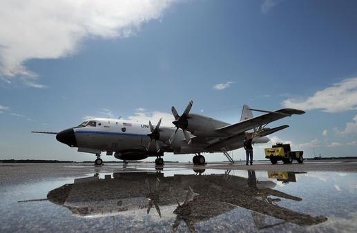
Photo credit above: A NOAA P-3 Orion turboprop named "Kermit" is seen on the tarmac prior to flight Tuesday. (Chris Urso).
"Hurricane Bob was one the costliest hurricanes in New England history. The second named storm and first hurricane of the 1991 Atlantic hurricane season, Bob developed from an area of low-pressure near The Bahamas on August 16. The depression steadily intensified, and became Tropical Storm Bob late on August 16. Bob curved north-northwestward after becoming a tropical storm, but re-curved to the north-northeast after becoming a hurricane on August 17. Bob brushed the Outer Banks of North Carolina as it moved north-northeastward on August 18 and August 19, and intensified into a major hurricane (Category 3+ Saffir-Simpson Hurricane Scale) shortly thereafter. After peaking with maximum sustained winds of 115 mph (185 km/h), Bob weakened slightly as it approached the coast of New England. Bob made landfall twice in Rhode Island as a Category 2 hurricane on August 19, first on Block Island and then in Newport. Bob was the only hurricane to make U.S. landfall during the 1991 season. As it continued inland, Bob rapidly weakened, and deteriorated to a tropical storm as it emerged into the Gulf of Maine. Shortly thereafter, Bob made landfall in Maine as a strong tropical storm early on August 20."
* Bob's Storm Surge Hit Coastal New England Very Hard. More from Wikipedia: "Hurricane Bob caused a storm surge of 6 to 10 feet (1.8 to 3.0 m) (above mean tide) along the Rhode Island shore, which would have resulted in four feet of water inundating downtown Providence had its protective hurricane barrier failed. The surge was worse (10 to 15 feet (4.6 m)) in Buzzards Bay. The Buzzards Bay shore east to Cape Cod was hardest hit. The highest surges, of 12 to 15 feet (4.6 m), were observed in Onset, Bourne, and Wareham, at the head of Buzzards Bay. Cove Road in Mattapoisett had 29 of 37 homes destroyed, while Angelica Point lost 32 of 35 homes along the shore. Boat damage was significant, as many boats were torn from their moorings. On lower Cape Cod, residents were without power or running water for several weeks after the storm had passed. Contracted electrical companies from as far away as Canada were called in to fix power lines downed as a result of the storm. Extensive beach erosion occurred along the shore from Westerly, Rhode Island eastward. Some south-facing beach locations on Martha's Vineyard and Nantucket lost up to 50 feet (15 m) of beach to erosion. Due to the extensive damage, President George H.W. Bush declared Rhode Island a "disaster area" because of Hurricane Bob."
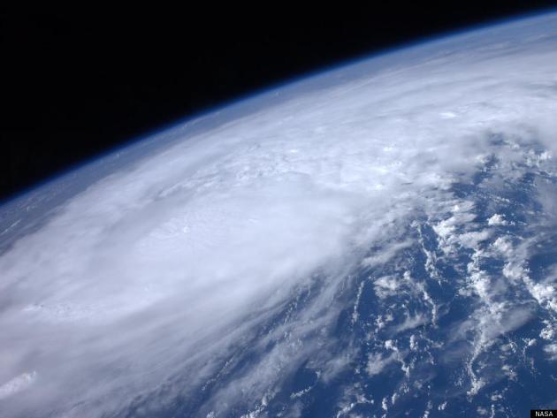
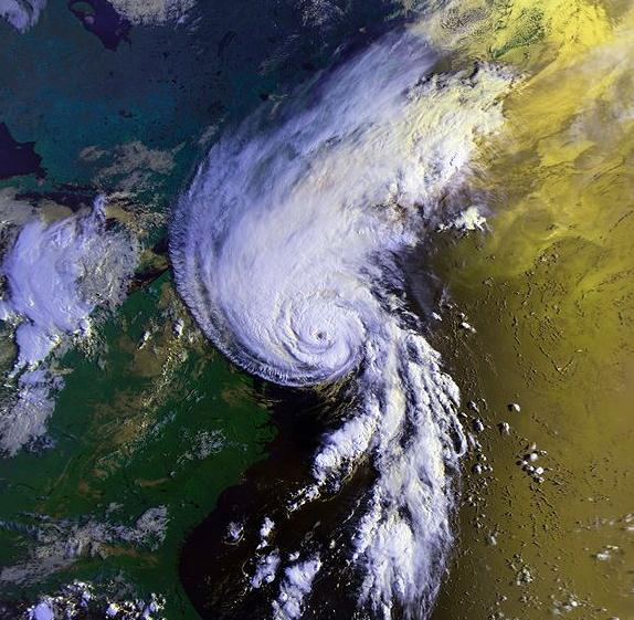
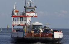
Hurricane Irene: U.S. Prepares For The Storm. Here's another perspective on "Irene" from the Huffington Post: "HATTERAS, N.C. -- Evacuations began on a tiny barrier island off North Carolina as Hurricane Irene strengthened to a major Category 3 storm over the Bahamas on Wednesday with the East Coast in its sights. Irene's maximum sustained winds increased to near 115 mph (185 kph) with additional strengthening forecast, the U.S. National Hurricane Center in Miami said. The evacuation in North Carolina was a test of whether people in the crosshairs of the first major hurricane along the East Coast in years would heed orders to get out of the way. The first ferry to leave Ocracoke Island arrived just before 5:30 a.m. in nearby Hatteras with around a dozen cars on board. It won't be easy to get thousands of people off Ocracoke Island, which is accessible only by boat. The 16-mile-long barrier island is home to about 800 year-round residents and a tourist population that swells into the thousands when vacationers rent rooms and cottages. Tourists were told to evacuate Wednesday. Island residents were told to get out on Thursday." (photo courtesy of NASA).
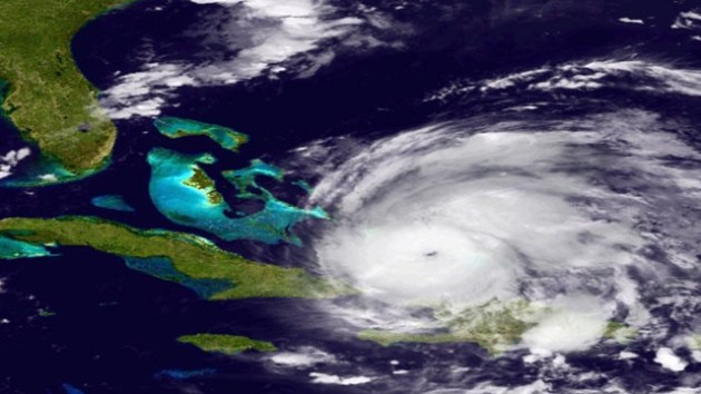
Hurricane Irene Strengthens As It Moves Toward U.S. The latest from the New York Times: "MIAMI — Hurricane-preparedness is now all about watching the cone. And on Tuesday, Hurricane Irene’s tracking cone curved just far enough away from the Florida peninsula to cause emergency officials up and down the state to breathe a cautious sigh of relief. “We are out of the cone at the moment, though we have seen it wobble in the past,” said Peter Elwell, the town manager in Palm Beach, Fla., referring to the constantly evolving cone on forecast maps that designates a hurricane’s probable path. “The cone moving away from us is a mixed bag: you know the bullet you are dodging is going to hit somebody else.” The mouth of the dangerous storm’s cone took dead aim on Tuesday at North Carolina, where officials scrambled to get ready. But federal and state authorities warned residents in other places not to be complacent; they said the hurricane would probably affect nearly every state along the East Coast. Forecasters at the National Hurricane Center here said they were becoming increasingly confident that Hurricane Irene, a Category 1 storm on the Saffir-Simpson wind scale late Tuesday with sustained winds of 90 miles per hour, would gradually increase in strength over the warm Gulf Stream waters. The Bahamas will bear the brunt of the storm over the next several days before it is expected to veer on a more northward path toward the Carolinas, forecasters said." (photo courtesy of NOAA).

This emergency supply kit should include:
• Three-or-more-day supply of food in airtight, waterproof container, and drinking water.
• Bowls for food and water."

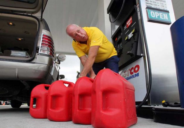
Hurricane Irene Scrambles More Cruise Schedules, Prompts Lines To Evacuate Private Islands. An update from USA Today: "As Hurricane Irene begins to pummel the Bahamas, more cruise lines have altered itineraries, and evacuated their private islands in the region. Earlier this week, Carnival Cruise Lines announced changes to seven itineraries and Royal Caribbean shifted four. Now as the storm's path has clarified, additional ships have been rerouted.Two Norwegian Cruise Line ships are dropping calls in the Bahamas:
- Norwegian Jewel will skip Nassau on Wednesday and head toward its home port of New York, where it's scheduled to arrive Saturday.
- Norwegian Sky will miss Great Stirrup Cay (the cruise line's private island) today, and spend the day at sea. It may also drop a planned visit to Freeport on Thursday and will complete its cruise in Miami on Friday, as planned."
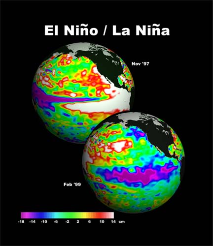
A Link Between El Nino And Violent Conflict? This is a new one, based on research just published in "Nature". NPR has more details: "Scientists say there's a link between climate and violent conflict. A statistical analysis of civil conflicts between 1950 and 2004 found that in tropical countries, conflicts were twice as likely to occur in El Nino years. The analysis appears in the journal Nature. El Nino occurs when there is unusually warm water in the Pacific Ocean near the equator. But it affects weather patterns in tropical countries around the globe."

Animal care staff recognized changes in animal behavior.
Great Apes
- The earthquake hit the Great Ape House and Think Tank Exhibit during afternoon feeding time.
- About five to ten seconds before the quake, many of the apes, including Kyle (an orangutan) and Kojo (a Western lowland gorilla), abandoned their food and climbed to the top of the tree-like structure in the exhibit.
- About three seconds before the quake, Mandara (a gorilla) let out a shriek and collected her baby, Kibibi, and moved to the top of the tree structure as well.
- Iris (an orangutan) began “belch vocalizing”—an unhappy/upset noise normally reserved for extreme irritation—before the quake and continued this vocalization following the quake.
Small Mammals
- The red ruffed lemurs sounded an alarm call about 15 minutes before the quake and then again just after it occurred."
Hurricane Preparation
I wonder how well meteorologists at the National Hurricane Center (a division of NOAA) sleep at night? If I'm wrong a picnic gets rained out; people get angry, but life goes on. If the hurricane forecasters misjudge the track of a hurricane, thousands, even millions of lives can be threatened. It's a thankless job: evacuations are expensive but if you don't issue a warning and the storm veers off-course, people may not have enough time to flee inland. Weather models do a pretty good job predicting the track of hurricanes, but the INTENSITY is tougher to pin down. The ECMWF (European) model prints out a 27.2" monster near the Outer Banks of N. Carolina by Sunday. A second landfall is still possible from Providence to Cape Cod. Since the track will stay over warm Gulf Stream waters, Irene may retain hurricane status into New England, taking a path similar to "Bob" in 1991. Flash flooding & coastal beach erosion is likely.
* photo above courtesy of ctpost.com.
Climate Stories....
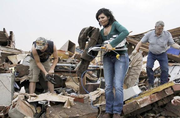
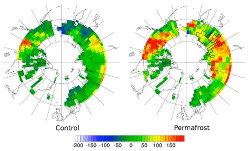
Photo credit above: "A sink becomes a source, as revealed by these two simulations of net CO2 fluxes due to climate change at the end of 21st century. The control simulation on the left did not include permafrost processes. The permafrost simulation on the right included processes that depict how carbon accumulates in soil and how it decomposes. In the latter simulation, large carbon losses are seen in central Canada where substantial permafrost stocks exist that are vulnerable to warming. Units are in grams of carbon per square meter per year."