First Flakes Next Week?
Why
does 50 degrees feel so much better in March than it does in October?
Perspective. After a run of 70s in September, extending into the first
11 days of October, next week will feel like a cold slap across the
face. Something I can relate to.
Long-range ECMWF (European)
guidance shows a good chance of flurries early next week, with a slight
risk of a coating by Tuesday morning. Lovely.
According to
Minnesota State Climatologist Greg Spoden the first coating (tenth of an
inch) usually comes by November 4 in the Twin Cities. We usually enjoy
our first flakes by mid-October.
The coldest temperature so far
this fall at MSP International: 39F. The first frost of the season is
possible Saturday morning, likely Sunday morning; a hard killing freeze
likely by the middle of next week. Right on schedule. Our first 28F low,
cold enough to kill off most plant-life, usually comes October 20,
based on 1948-2005 records.
Rain showers arrive tonight ahead of
the next chilly surge, more showers late Sunday. Colder air behind that
front will probably spark snow flurries/showers next Monday night &
Tuesday.
My forecast: snowmobilers are about to develop an itch that a scratch won't reach.
More November Than October.
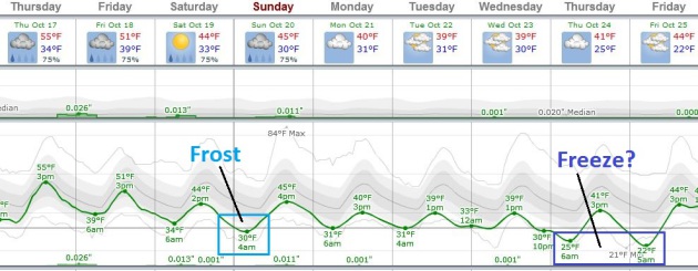
ECMWF data shows 40s over the weekend, possibly a few days in the upper
30s next week. A frost is possible Sunday morning, a hard freeze
possible by the end of next week with a couple nights in the mid to
upper 20s in the metro. Have you taken out the dock and boat yet? Might
be a good idea to move things along in the coming days. Graph:
WeatherSpark.
No Cause For Panic - Yet.
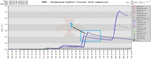
I'm not buying a few of the GFS runs predicting a couple inches of snow
next week, although I can't rule out a dusting or coating on lawns and
fields next Monday night. It's too early for specificity, but the
atmosphere will be cold enough for flurries and snow showers next week.
Here we go. Graph: Iowa State.
A Parade Of Cold Fronts.
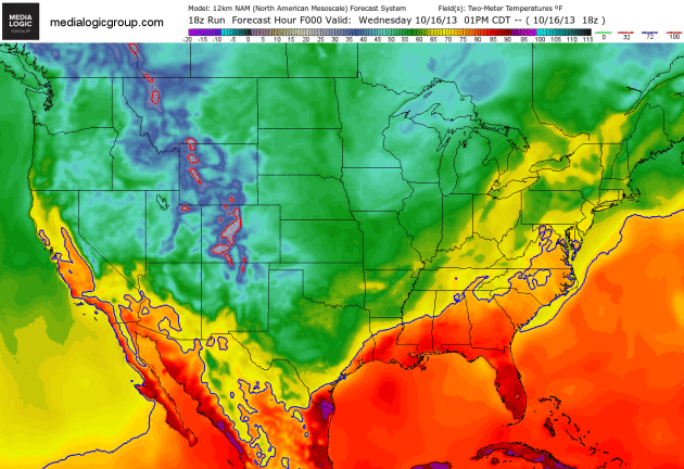
The 84-hour NAM forecast shows colder air pushing south into the Plains
and Upper Midwest into the weekend. The red-outlined regions show
temperatures colder than 32 F. By next week it may look and feel more
like mid-November than mid-October. Map: NOAA and Ham Weather.
A Chilly Halloween Shaping Up.
Payback time for a balmy September and lukewarm start to October? GFS
data shows highs in the 30s on October 21, nights dipping into the low
and mid 20s. The forecast calls for a few extra layers under that fancy
costume.
 First Coating Of Snow For Select Cities?
 Yes,
this is my way of cheering you up on a Thursday. Thanks to State
Climatologist Greg Spoden for providing me with this information. Bottom
line, the mean (average) date of the first coating (tenth of an inch or
more) in the Twin Cities is November 4. More details at
this site:
Minneapolis/St. Paul International Airport - Date of First Snowfall => 0.1"(period of record: 1938 - 2012)
mean: November 4
earliest: September 24, 1985
latest: December 2, 1963
Duluth International Airport - Date of First Snowfall => 0.1"(period of record: 1948 - 2012)
mean: October 23
earliest: September 18, 1991 (* note: very early snowfall last year - September 21, 2012 *)
latest: November 26, 2004
International Falls Airport - Date of First Snowfall => 0.1"(period of record: 1948 - 2012)
mean: October 19
earliest: September 14, 1964
latest: December 8, 1999
Fargo International Airport - Date of First Snowfall => 0.1"(period of record: 1942 - 2012)
mean: November 2
earliest: September 25, 1942
latest: December 14, 1999
Rochester International Airport - Date of First Snowfall => 0.1"(period of record: 1933 - 2012)
mean: November 5
earliest: September 26, 1942
latest: December 19, 1939
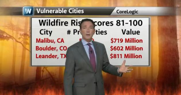
Growing Wildfire Risk.
The trends are clear: as the West continues to dry out and warm up
wildfires are becoming bigger, and more intense over time. CoreLogic
just released an update on the most vulnerable states and metropolitan
areas. Texas and Colorado top the list, but in terms of insured property
at risk California is also very much at risk. Details in today's
edition of
Climate Matters.
 Ask Paul
. Weather-related Q&A:
"
I
have put off some exterior painting. Will there be a day soon when I
can safely paint outside? I think the paint folk say a minimum of 50
degrees is required."
Virginia Fuhrken
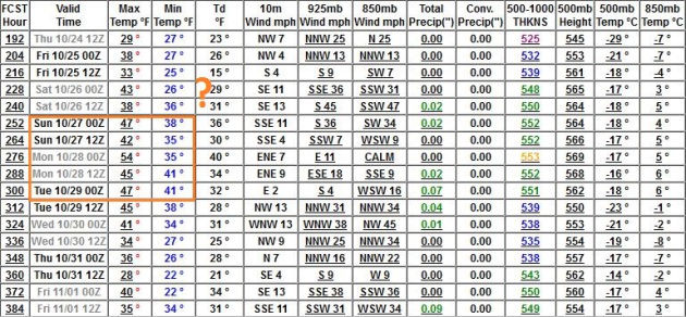
Virginia -
there's little doubt we're heading into a cold part of the cycle,
temperatures trending (well) below average the next 2 weeks, probably
through the end of October. The GFS solution (below) shows a slight
upward blip in temperatures around October 27-28, followed by a colder
front in time for Halloween; not sure you'll see a series of days above
50F, but some temporary reprieve from the chill is possible into the
first half of November.
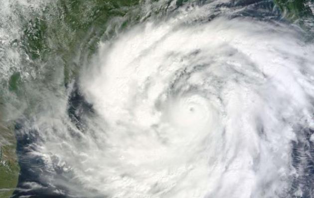
Super Cyclonic Storm Phailin: The Strongest Storm Ever In The North Indian Ocean Basin. LiveScience puts Typhoon Phailin into perspective - here's an excerpt: "
Phailin
(the Thai word for sapphire) is officially the strongest tropical
cyclone ever recorded to make landfall over India. Phailin had begun as a
tropical storm with 105kph (65mph) winds, but rapidly intensified on
October 10 2013 to 250kph (155mph). It was upgraded to a super cyclonic
storm, which is equivalent to Category 5 in the Saffir-Simpson Scale for
the North Western Atlantic Ocean (NWA) Basin..."
Photo credit above: "
Cyclone Phailin hit the Indian state of Orisha on Saturday night." EPA/STR.
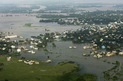
A Fishing Community Recounts Evacuation Experience During (Typhoon) Phailin.
Using force to evacuate people in the projected path of a severe
typhoon? I haven't seen that before - but evacuating nearly 1 million
Indians in the path of Phailin undoubtedly saved hundreds, possibly
thousands of lives. Here's a clip from
The New York Times: "...
After
pleading for hours with unwilling villagers to relocate, the
authorities said they began to use force, although no violence was
involved. Under the National Disaster Management Act, district
administrations may use force during a disaster in order to remove
people from vulnerable areas..."
Photo credit above: "
An
aerial view shows an area flooded by heavy rains in the aftermath of
Cyclone Phailin in Balasore district, Orissa state, India, Tuesday, Oct.
15, 2013. A mass government evacuation of nearly 1 million people
spared India the widespread deaths many had feared from the powerful
weekend cyclone Phailin, which destroyed hundreds of millions of
dollars' worth of crops and tens of thousands of homes." (AP Photo)
New Views Of Sandy. Here's a clip from a fascinating article at
UCAR
explaining some of the factors that contributed to Superstorm Sandy's
size, ferocity and outsized storm surge (for a Category 1 strength storm
at landfall on October 29, 2012): "...
Since the January AMS
meeting, Tom Galarneau, along with NCAR colleagues Chris Davis and Mel
Shapiro, have analyzed additional AHW simulations, which they describe
in the just-released paper. They explain that Sandy’s life cycle—unique
in Atlantic hurricane annals—was actually a blend of several
well-studied phenomena that hadn’t been previously shown to come
together in such a way near a major coastline. As Sandy moved
northeast, contrasting air masses created a pseudo-frontal system along
the edge of the Gulf Stream’s warm water. The vorticity, or circulation,
along this frontal zone (picture an atmospheric rolling pin oriented
along the Gulf Stream) was gradually ingested by Sandy and tilted into
vertical vorticity (now picture the rolling pin standing on one end).
This helped the storm’s core to intensify, tighten, and regain its
Category 2 status. It’s roughly similar to the smaller-scale process by
which a supercell thunderstorm can ingest, tilt, and concentrate
spinning air to produce storm-scale circulations (some of which can
generate tornadoes)..."
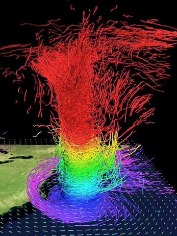
Image credit above: "
In
this 3-D map of potential temperature, relatively cool air wraps around
Sandy's core near the surface (purple and blue colors), while air
parcels gain heat from moisture condensing into clouds and precipitation
as they ascend through the storm’s core." For more details on this simulation, see the
YouTube videos below. (©UCAR. Image courtesy Mel Shapiro, NCAR).
All Taxpayers Are Footing The Cost Of Fighting High-Risk Wildfires.
MinnPost has more details; here's an excerpt: "...
While
the property losses may be confined to unfortunate homeowners (and
others in their hazard insurance pool), the firefighting costs incurred
by the U.S. Forest Service are borne by the Minnesota taxpayer on an
equal footing with Coloradans and Californians, and driven up by
continuing new construction in the fire zone. The 2013 season may
actually turn out to be milder than some recent years — though still
more destructive than long-term averages —despite huge fires in
Colorado, California and Arizona, including the Yarnell Peak fire that
killed 19 elite firefighters in June..."
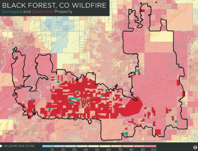
Graphic credit above: Courtesy of CoreLogic. "
This
map shows a section of the wildland-urban interface outside Colorado
Springs, where the Black Forest fire last June became the worst in
Colorado history as measured by property loss. Areas with a wildfire
risk score above 60 are considered at high risk of wildfire, and areas
above 80 are at very high risk. In 10 days the blaze destroyed more than
500 homes and damaged many more."
Jellyfish Are Taking Over The Seas, And It Might Be Too Late To Stop Them.
Bad sushi anyone? Is this a result of more acidic ocean water, or more
pollution? No idea, but this story makes me appreciate Minnesota's
(jellyfish-free) lakes even more. Here's an excerpt from
Quartz: "...
Coastal
areas around the world have struggled with similar jellyfish blooms, as
these population explosions are known. These blooms are increasing in
intensity, frequency, or duration, says Lucas Brotz, a jellyfish expert
at the University of British Columbia. Brotz’s research of 45 major marine ecosystems shows that 62% saw an uptick in blooms (pdf)
since 1950. In those areas, surging jellyfish numbers have caused power
plant outages, destroyed fisheries and cluttered the beaches of holiday
destinations. (Scientists can’t be certain that blooms are rising
because historical data are too few.)..."
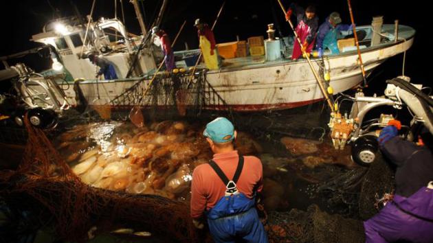
Photo credit above: "
The Nomura jellyfish invasion has plagued Japanese fishermen—and probably stems from pollution in China’s Yangtze River." AP Photo/Junji Kurokawa.
Marine Science Teacher Finds Carcass Of 18-Foot-Long Sea Creature Off California Coast. Hey kids, let's go to the beach and swim in the ocean! I think I'll pass and see a movie instead, after reading this story at
The Star Tribune; here's an excerpt: "
A
marine science instructor snorkeling off the Southern California coast
spotted something out of a fantasy novel: the silvery carcass of an
18-foot-long, serpent-like oarfish. Jasmine Santana of the Catalina
Island Marine Institute needed more than 15 helpers to drag the giant
sea creature with eyes the size of half dollars to shore Sunday.
Staffers at the institute are calling it the discovery of a lifetime.
"We've never seen a fish this big," said Mark Waddington, senior captain
of the Tole Mour, CIMI's sail training ship. "The last oarfish we saw
was three feet long..."
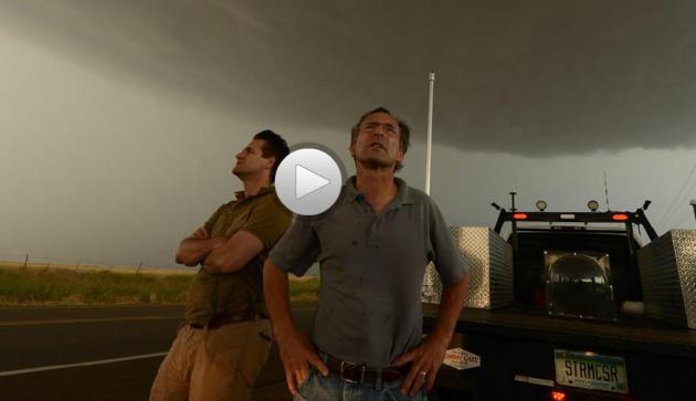
"The Last Chase". Robert Draper at
National Geographic
has a detailed, and haunting account of research meteorologist and
veteran tornado chaser Tim Samaras's deadly encounter with a massive
tornado in May; here's the introduction: "
It’s shortly after six in
the evening on May 31, 2013. Sitting in the passenger seat of the white
Chevrolet Cobalt, the 55-year-old, bookishly handsome storm chaser
momentarily gapes at the video camera that the driver of the car is
pointing at his face. Then he looks back through the window at the
outskirts of El Reno, Oklahoma. The wheat fields are eerily aglow and
shudder from a vicious wind. No more than two miles away from the car,
twin funnel clouds spiral downward from an immensity of blackness. What
we hear in the man’s voice on the videotape is not quite terror. Nor,
however, do his words sound clinically factual, in the manner of the
scientist he happens to be. “Oh, my God. This is gonna be a huge one,”
he says..."
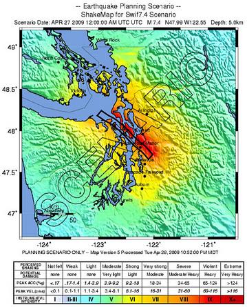
A Tsunami-Proof Elementary School Gymnasium? We have to worry about blizzards, floods and tornadoes here in Minnesota, but this story from
The Seattle Times
helped me to keep some perspective; a local school district is planning
vertical evacuations in the event of a major quake and resulting
tsunami - here's an excerpt: "
A new scenario
for a megaquake and tsunami off the Washington coast warns that the
death toll could top 10,000 — but Paula Akerlund is doing everything she
can to keep her kids safe. All 700 of them. The Grays Harbor County
school district Akerlund oversees on the Washington coast is preparing
to build the nation’s first tsunami refuge. Residents of Westport,
Grayland and other communities in the Ocosta School District
approved a $13.8 million bond issue earlier this year to replace a
flimsy elementary-school building with a complex that includes a gym
strong enough to withstand tsunami surges, tall enough to stay dry and
big enough to shelter more than 1,000 people on its roof..."
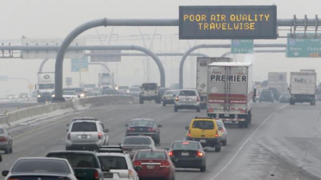
More Americans Die From Car Pollution Than Car Accidents. This headline made me do a double-take; here's a clip from
Quartz: "
Some day our descendants will marvel that we ever lived in cities filled with emissions direct from the tailpipes of cars. A new study from MIT
suggests that in the US, 53,000 people a year die prematurely because
of automobile pollution, compared to 34,000 people a year who die in
traffic accidents. These results more than double the number of people who die in the US every year as a result of automobiles, to nearly 100,000. One in five Americans is in danger from air pollution, and it appears that the hazard is primarily their proximity to roadways.."
Photo credit above: "
You might be able to avoid a pile-up, but you can't escape the smog." AP Photo/Rick Bowmer.
* Photo above courtesy of Timothy Butz.
Climate Stories...
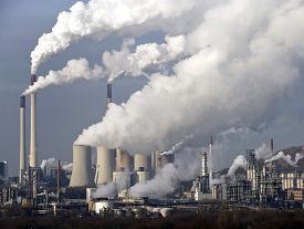
Supreme Courty Agrees To Hear Greenhouse Gas Case. The Los Angeles Times has the story - here's the introduction: "
The
Supreme Court has agreed to hear a utility industry challenge to the
Obama administration’s environmental regulations that would limit
greenhouse gases coming from power plants and factories. The justices
agreed to rule on whether the Environmental Protection Agency’s
restrictions involving motor vehicles give the agency the power to
impose similar restrictions on “stationary sources that emit greenhouse
gases,” which would include everything from power plants and refineries
to apartment buildings and factories. The court, however, turned away
the most aggressive challenges to the EPA’s authority to regulate
heat-trapping greenhouse gas emissions..."
The U.S. Is Now The Biggest Oil Producer In The World. Fracking (shale oil extracted via hydraulic fracture) has pushed us over the top. Here's a clip from an eye-opening story at
Fast Company: "
So
long, Saudi Arabia. The U.S. is projected to be the biggest supplier of
oil in the world this year when biofuels and natural gas liquids are
taken into account, according to data released from PIRA Energy Group.
The growth in U.S. oil production has been rapid--it was just last year
that the U.S. overtook Russia to claim the second place spot. Now,
thanks to the shale oil boom, the U.S. has climbed above even the Middle
Eastern oil empire of Saudi Arabia. And while both Saudi Arabia and the
U.S. increased oil production in 2013, the U.S. ramped up production
faster than the Saudis. According to a press release from PIRA,
the U.S. oil "growth rate is greater than the sum of the growth of the
next nine fastest growing countries combined and has covered most of the
world's net demand growth over the past two years..." (Image: Clean Technica).
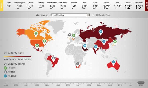
These Maps Show Where The U.S. Is Most Vulnerable To Oil Shocks.
The Washington Post provides perspective - here's an excerpt: "
How do America's vulnerabilities compare globally? For that we can turn to the "Oil Security Index,"
a new project from Securing America's Future Energy (SAFE) and Roubini
Global Economics. The United States, they find, is still more exposed
than most other advanced economies to disruptions in the global oil
supply.."
Response To Readers: Combating Climate Change With Nuclear Power And Fracking.
There's a link to the original article and a follow-up from the author.
Is nuclear power and fracking the lesser of the energy evils when
compared to coal? Here's an excerpt to an article at
Forbes: "
With
more than 7,500 views and 180-plus tweets, I want to thank everyone for
taking the time to read the original HBS Working Knowledge piece, The Case for Combating Climate Change with Nuclear Power and Fracking,
and, in particular, for sharing your thoughts with one another. I don’t
expect the article has changed minds, but I do hope it encourages
people to open their minds to consider new possibilities. Things that
were once seen as relatively safe are now understood as likely to be
quite dangerous, such as coal burning’s contribution to global warming
driven by worldwide cumulative CO2 emissions. Perhaps, the opposite is
also true. Are things that were once seen as quite dangerous now
potentially relatively safe as result of new understandings and
innovations?..."