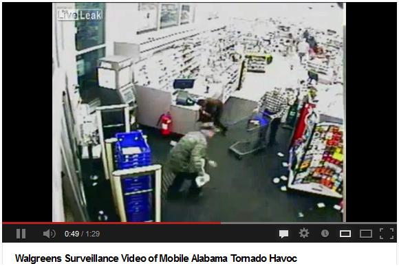
Take a look at this
surviellance video from a Walgreens store out of Mobile, AL during the
Christmas tornado outbreak. I'm SHOCKED that there weren't as many
fatalities as there could have been.
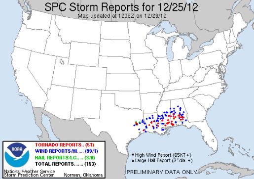
Updated Christmas Day Tornado Count
The Storm Prediction
Center continues to update the tornado tally from the Christmas Day
outbreak. The unfiltered PRELIMINARY reports are now up to 51!
"Nationwide, at
least 17 people died because of the ice, snow and wind. Deaths from
wind-toppled trees also were reported in Texas and Louisiana, but car
crashes caused most of the fatalities."
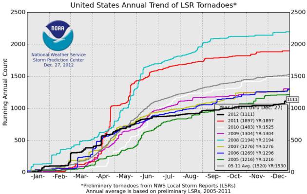
2012 Tornado Count
Despite the recent
flurry of tornado activity, 2012 will end well below the average annual
tornado count. According to the SPC, as of December 27th, there were
1,111 tornado reports nearly 400 below the 7year average of 1530.
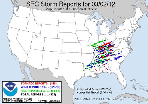
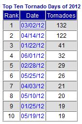
Top 10 Tornado Days of 2012
The Storm Prediction
Center has a list of the top 10 tornado days of 2012... the most active
days was March 2nd when 160 tornadoes were reported (actual 132).
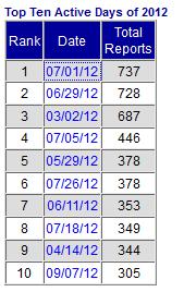
Most Active Severe Weather Days of 2012
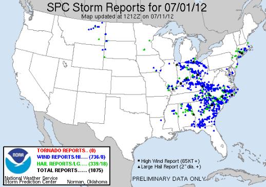
The information
below from the SPC shows the top 10 most active severe weather days of
2012. Preliminary data from July 1st, 2012 had over 1,000 storm reports,
a number that was refined to 737. Intense heat across the mid-section
of the nation allowed for severe thunderstorms to develop on its
northern periphery. These thunderstorms created long lived straight-line
wind producing storms. Look at all the wind damage reports (in blue)
from the Great Lakes to Florida! The other BIG day was June 29th.
Canada Blizzard
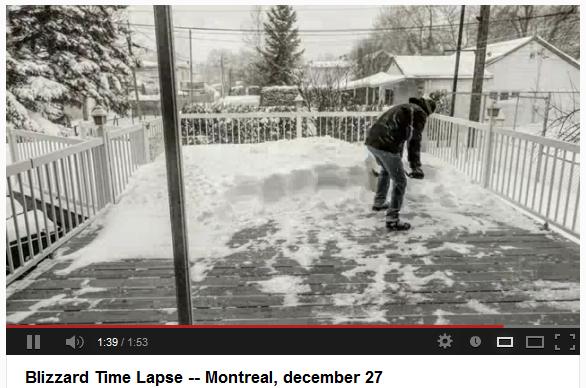
I thought this was
kind of neat, it's a time lapse of a blizzard out of Montreal Canada,
which is north of Burlington, VT. This is from the same storm system
that produced snow in Texas and the tornado outbreak earlier this week.
Air Travel Troubles?
Another winter
storm/system is bearing down on the Northeast through the early weekend.
It appears snow amounts won't be quite as dramatic as they were this
last week, but this will still be responsible for some travel troubles.
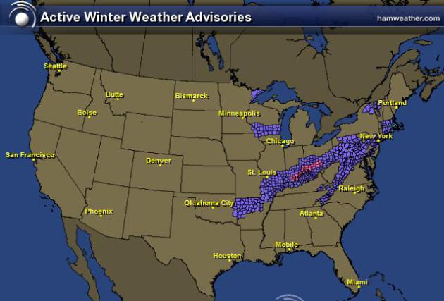
The graphic below shows the winter weather headlines that have been
posted through the weekend.
Northeast Snow Forecast
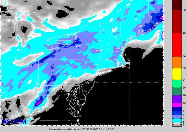
According to the
RPM model, there is going to be a moderate swath of 2" to 4" with
localized areas of 4" to 8" through the weekend.
Saturday Outlook
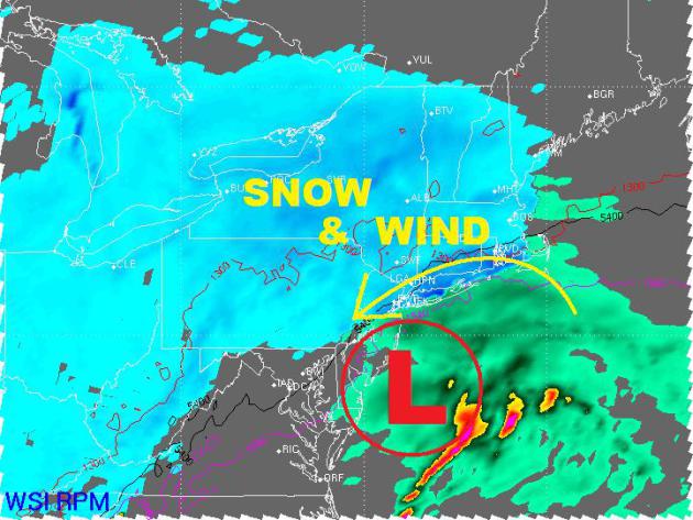
Here's the weather
map for PM Saturday, which shows the center of circulation south of New
York, but there will be decent wind and snow across some busy places
that may be more than just an inconvenience tro travelers. Moderate to
heavy snow totals along with wind gusts close to 30mph will create
problems on the ground and by air.
Cold Start to 2013
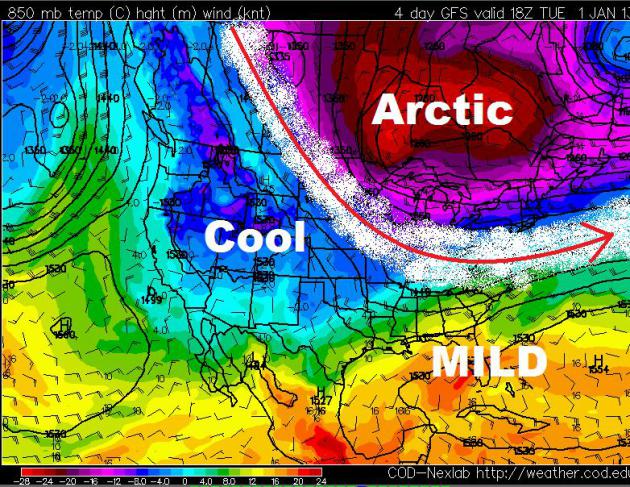
The forecast calls for a fairly
cold star to 2013. Thanks to a big dip in the jet stream, cold air from
the Arctic regions will continue to refrigerate much of the Lower 48
through the early part of 2013.
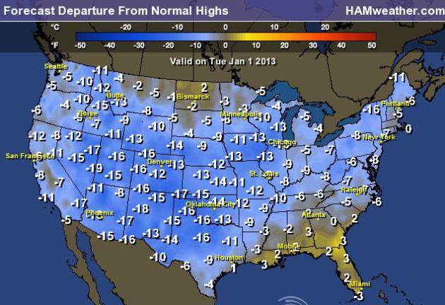
Cold Start to 2013
The extended forecast calls for a
fairly cold start to 2013 across much of the nation. Here's a look at
the high temperature from normal forecast for Tuesday, January 1st,
2013... Brr!
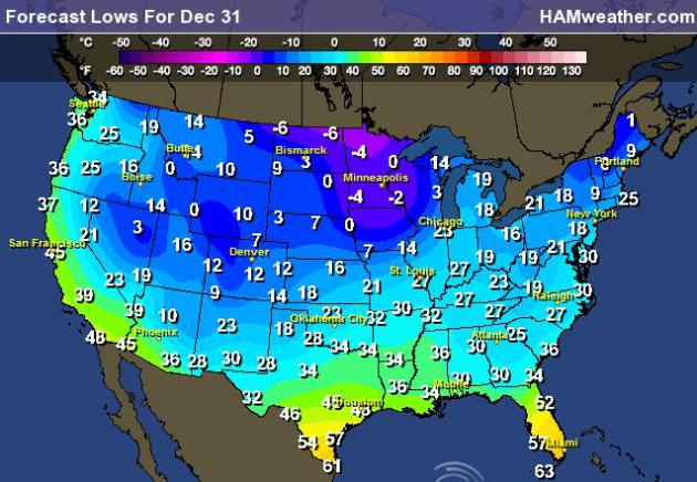
Ringing in the New Year
If you have plans to be out and
about through New Year's Eve night, take a look at the forecast low
temperatures for the night... Brr again! Make sure to bring the extra
layer along to the ball, you'll need it after the clock strikes midnight
otherwise you'll turn into a frozen pumpkin!
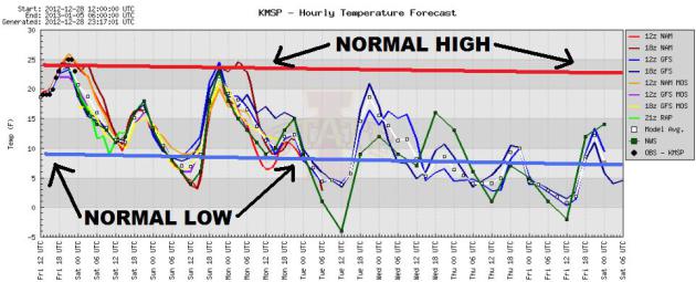
Below Normal Temps
The extended forecast for
Minneapolis calls for generally below normal temps from the end of
December through the first part of January. Temperature may consistently
bottom out near the sub-zero mark.
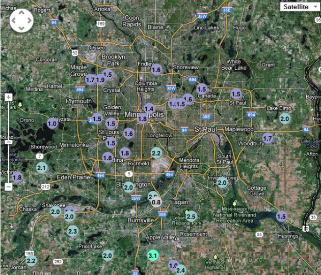
Latest Snow Reports
Here's a list of the latest snow
reports from Thursday-Friday. Even though there wasn't much moisture
with this system, cold temperatures allowed the snow to really fluff up!
Reports of 1" to 3" across the Twin Cities was pretty common.
Thanks for checking in and have a great weekend ahead!
Don't forget to follow me on Twitter @TNelsonWNTV
