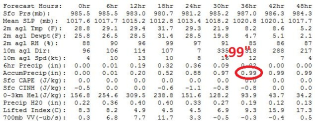
* heaviest snow: morning into early afternoon Sunday. Snow may fall at the rate of 1" hour during the AM hours.
* temperatures near freezing morning hours: meaning heavy, wet, slushy snow. Temperatures drop into the 20s by afternoon, meaning a more powdery snow by late afternoon, more prone to blowing/drifting.
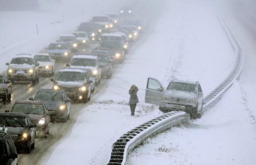
* Blizzard Warnings posted for parts of central and west central Minnesota. Never tell a Minnesotan not to travel, but I would seriously think twice on Sunday, especially heading west on 7 or 12. White-out conditions are possible as close to the metro as Mankato, Willmar and Glencoe.

Looks Like Snow
Snow. Noun. "Atmospheric water vapor frozen into ice crystals and falling in light white flakes or lying on the ground as a white layer."
Maybe absence really does make the heart grow
fonder. At least it's Sunday, when travel is optional for many. Kids of
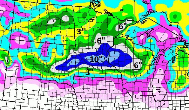
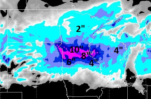
all ages will look longingly out the window. Expect 5-10", definitely enough to shovel and plow, and fashion into formidable snowballs.
Snow gets a bad rap; a source of traffic snarls
and broken hips. But snow is democratic and equal opportunity. That, and
my nasty-looking lawn just got an upgrade.
Go slow out there; snow tapers by evening; the
axis of heaviest snowfall forecast to set up from Willmar into the Twin
Cities, the most snow from a single storm since December, 2010.
Cold winds kicking in behind the storm may
create blizzard conditions as close as Willmar & Mankato. Better to
wax the skis and exercise a snowmobile.
Welcome to the first inch or more of snow (in
one day) in the Twin Cities since February 29. Chicago has gone 280 days
without measurable snow, a record 279 days at Milwaukee.
More accumulating snow may fall next Saturday; no big thaws the next 2 weeks. Yes, we will have a white Christmas after all.
The last 2 weeks have reminded me to take nothing for granted. See the beauty in every one and everything.
Even a (rare) MSP snowfall.
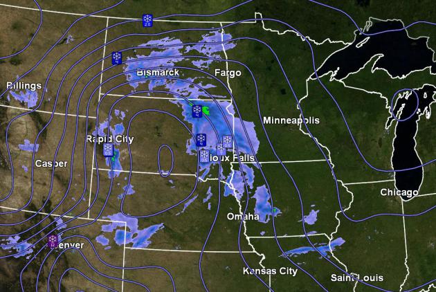
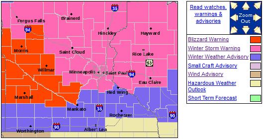
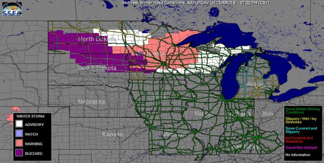
URGENT - WINTER WEATHER MESSAGE
NATIONAL WEATHER SERVICE TWIN CITIES/CHANHASSEN MN
336 PM CST SAT DEC 8 2012

...MAJOR WINTER STORM BEARING DOWN ON THE UPPER MIDWEST TONIGHT
THROUGH SUNDAY EVENING...
...BLIZZARD CONDITIONS EXPECTED ACROSS WESTERN MINNESOTA SUNDAY
AFTERNOON AND EVENING...

.A POWERFUL WINTER STORM CONTINUES TO ORGANIZE ACROSS THE DAKOTAS
AND WILL BEGIN AFFECTING WESTERN MINNESOTA THIS EVENING...AND
EASTERN MINNESOTA AND WESTERN WISCONSIN AFTER MIDNIGHT. LOW
PRESSURE WILL TRACK FROM ABOUT NEW ULM TO ROCHESTER ON SUNDAY
WHICH IS A LITTLE FURTHER SOUTH THAN EARLIER ANTICIPATED. MODERATE
TO HEAVY SNOW CAN BE EXPECTED AHEAD AND NORTH OF THIS LOW TRACK
TONIGHT AND SUNDAY.

BECAUSE COMPUTER MODELS HAVE SHIFTED SOUTH WITH THE TRACK OF THE
LOW...WINTER STORM WARNINGS AND WINTER WEATHER ADVISORIES HAVE
ALSO SHIFTED SOUTH. WINTER STORM WARNINGS ARE NOW IN EFFECT NORTH
OF A LINE FROM REDWOOD FALLS...TO RED WING MINNESOTA...AND EAU
CLAIRE WISCONSIN TONIGHT THROUGH SUNDAY EVENING. TOTAL
ACCUMULATIONS WILL RANGE FROM 5 TO 9 INCHES...WITH THE HEAVIEST
TOTALS NORTHEAST OF INTERSTATE 94.

WINTER WEATHER ADVISORIES HAVE BEEN ISSUED SOUTH OF THE WINTER
STORM WARNING DOWN TO THE IOWA BORDER TONIGHT THROUGH SUNDAY
EVENING. TOTAL ACCUMULATIONS HERE WILL RANGE FROM 3 TO 5 INCHES.

BEHIND THE LOW PRESSURE SYSTEM...SUSTAINED NORTHWEST WINDS OF 25
TO 35 MPH ARE EXPECTED OVER WESTERN MINNESOTA SUNDAY AFTERNOON
BEFORE TAPERING OFF GRADUALLY SUNDAY EVENING. SOME GUSTS MAY
EXCEED 40 TO 45 MPH. CONSIDERABLE BLOWING AND DRIFTING SNOW WILL
RESULT IN WHITEOUT CONDITIONS MAKING TRAVEL NEARLY IMPOSSIBLE BY
SUNDAY AFTERNOON. THEREFORE...A BLIZZARD WARNING WILL REPLACE THE
WINTER STORM WARNING FROM 11 AM SUNDAY THROUGH MIDNIGHT SUNDAY NIGHT
WEST OF A LINE FROM MANKATO TO ALEXANDRIA. AREAS OF BLOWING AND
DRIFTING SNOW ARE ALSO EXPECTED FURTHER EAST...BUT LIGHTER WINDS
PRECLUDE THE ISSUANCE OF A BLIZZARD WARNING AT THIS TIME.

TEMPERATURES WILL PLUMMET BEHIND THE SYSTEM TO WELL BELOW ZERO
LATE SUNDAY NIGHT OVER WESTERN MINNESOTA WITH WIND CHILL READINGS
AS LOW AS 20 TO 30 BELOW. DO NOT TRAVEL. SHOULD YOUR VEHICLE GET
STUCK...YOUR LIFE WILL BE AT RISK.


...WINTER WEATHER ADVISORY NOW IN EFFECT FROM 6 PM THIS EVENING
TO 11 AM CST SUNDAY...
...BLIZZARD WARNING IN EFFECT FROM 11 AM SUNDAY TO MIDNIGHT CST
SUNDAY NIGHT...

THE NATIONAL WEATHER SERVICE IN TWIN CITIES/CHANHASSEN HAS ISSUED
A BLIZZARD WARNING...WHICH IS IN EFFECT FROM 11 AM SUNDAY TO
MIDNIGHT CST SUNDAY NIGHT.

* TIMING...SNOW...HEAVY AT TIMES...WILL BEGIN EARLY THIS EVENING
  AND CONTINUE INTO SUNDAY MORNING. THE HEAVY SNOW WILL TAPER OFF
  SUNDAY AFTERNOON WITH A FEW SNOW SHOWERS EXPECTED THEREAFTER.
  THE WIND WILL THEN INCREASE FROM THE NORTHWEST WITH BLIZZARD
  CONDITIONS EXPECTED INTO SUNDAY EVENING.

* WINDS/VISIBILITY...NORTHWEST WINDS WILL INCREASE TO 25 TO 35 MPH
  WITH GUSTS AS HIGH AS 45 MPH SUNDAY AFTERNOON AND EVENING.
  CONSIDERABLE BLOWING AND DRIFTING SNOW WILL RESULT IN WHITEOUT
  CONDITIONS SUNDAY AFTERNOON AND EVENING WITH NEAR ZERO
  VISIBILITY.

* SNOW ACCUMULATIONS...4 TO 6 INCHES.

* TEMPERATURES...UPPER 20S EARLY ON SUNDAY WILL PLUMMET BEHIND THE
  SYSTEM INTO THE TEENS BY LATE SUNDAY AFTERNOON...AND ZERO TO 5
  BELOW LATE SUNDAY NIGHT. WIND CHILLS WILL FALL TO 20 TO 25 BELOW.

PRECAUTIONARY/PREPAREDNESS ACTIONS...

A BLIZZARD WARNING MEANS SEVERE WINTER WEATHER CONDITIONS ARE
EXPECTED OR OCCURRING. FALLING AND BLOWING SNOW WITH STRONG WINDS
AND POOR VISIBILITIES ARE LIKELY. THIS WILL LEAD TO WHITEOUT
CONDITIONS...MAKING TRAVEL EXTREMELY DANGEROUS. DO NOT TRAVEL. IF
YOU MUST TRAVEL...HAVE A WINTER SURVIVAL KIT WITH YOU. IF YOU GET
STRANDED...STAY WITH YOUR VEHICLE.