29 F. high in the Twin Cities Saturday.
25 F. average high for December 22.
28 F. high on December 22, 2011.
1" snow on the ground in the Twin Cities.
10-15 F. high on Christmas Day - at least the sun will be out.
Couple inches of snow possible Friday into Saturday as the next storm passes to our south/east.

A Super-Sized 2012
I'm exhausted.
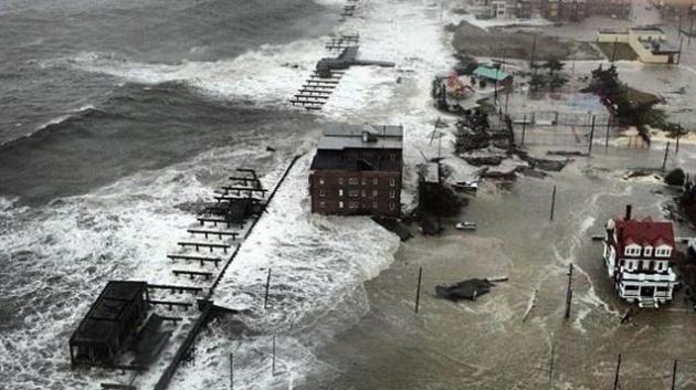
2012 was the second costliest year for weather
disasters, second only to 2005, when 4 hurricanes (including Katrina)
hit the USA. Sandy? 3 times larger than Katrina. 2012 brought a record
derecho, a 1-in-500 year flood in Duluth; the warmest year on record for
Minnesota and America.
TPT Almanac's news guru Cathy Wurzer asked me
what I thought 2012's big weather story would be for Minnesota.
"Drought". Forget fiscal cliffs; we fell off a moisture cliff by late
summer. Nationwide it's the worst drought since 1956. Unless we see
heavy rains in early spring - next year could bring back unpleasant
memories of 1988.
I don't think we're imagining it: the velocity of weather has changed. Record floods in 2011, then record drought a year later?
Crazy extremes.
We cool off today - next week one of the colder
weeks of a winter that (in my estimation) will wind up warmer than
average. Not as freakishly mild as last winter, but definitely above
average.
The eastern U.S. experiences a family of big
(rain) storms next week; heavy snow for New England. A cold Christmas
Day here gives way to a light snowfall Friday & Saturday.
For now keep your snowy expectations low.
* graphic above courtesy of Climate Central.
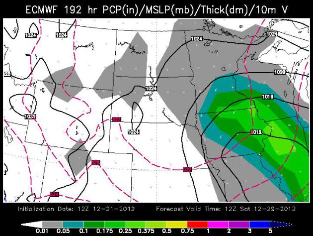
Late Week Snow. We may just squeak thru a white Christmas this year - I expect
about 1" of snow on the ground (officially) at MSP Tuesday morning.
Anything under 1" is considered a brown Christmas. The ECMWF (WSI) map
above is for Saturday morning; a couple inches of snow may fall Friday
into Saturday.
#5 Non-Winter of 2011-12
Some of the predictions were dire. Possibly a winter more snowy than 2010-2011 was in the cards. It didn't happen. One of the most wimpy winters ever seen in the Twin Cities and Minnesota was the result with mild temperatures and scant snowfall. 2011-12 wound up the tenth least snowy winter on record for the Twin Cities and was the fourth warmest winter on record.
#4 Hot July 2012
2012 was the second warmest month ever for the Twin Cities back to 1872 with 80.2 degrees. Only July 1936 was warmer with 81.4 degrees. Duluth had its warmest July on record, although in 1936, the recording station for Duluth was closer to Lake Superior. To escape the heat, one had to go to International Falls where the average July temperature was 69 degrees making 2012 only the 12th warmest July on record there.
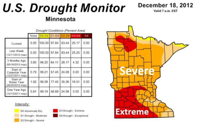
#3 Drought of 2011-2012
This could easily be #1 depending on where you live in Minnesota. The heavy rains of May and June, 2012 helped to blunt the drought a bit, but then it intensified by the late summer and continued into the fall. By late November 80% of the state was under a severe or extreme drought. By fall, soil moisture levels at the University of Minnesota Southern Research and Outreach Center in Waseca were some of the lowest on record.
#2 Northeast Minnesota Flood of June 19-20
The largest flash flood event in Minnesota for 2012 struck northeast Minnesota on June 19-20. The largest two day total was 10.10 inches just northeast of Duluth. There were so many roads flooded out in Carlton County that the county rain out of signs and more had to be trucked from the Twin Cities. One of the iconic photos of the storm was of Feisty the seal who escaped the Lake Superior Zoo and wound up on a neighborhood street. The St. Louis River engulfed and nearly destroyed the Jay Cooke State Park Swinging Bridge, but it will reopen in the summer of 2013. As for Feisty? She found refuge at Como Zoo and now has over 800 followers on Twitter.
#1 Outrageously Mild March 2012
Imagine if you will a March that was so warm it would break six record high temperature records in the Twin Cities, have four days with muggy dew point temperatures that reached 60 and wound up warmer than October! To top it off the Twin Cities had its earliest 80 degree temperature ever with 80 degrees on St. Patrick's Day, March 17. The old record was March 23 back in 1910. March 2012 will go down in history as one of the most bizarre months temperature-wise, finishing 15.5 degrees above normal. The only other month in the historical record for the Twin Cities that matches this feat was January 2006 that also finished 15.5 degrees above normal. As a consequence, spring phenology was exceedingly early with lilacs blooming the earliest on record in the Twin Cities, with many in full bloom by mid April.
Paul's Conservation Minnesota Outlook for the Twin Cities and all of Minnesota:
TODAY: More clouds than sun, colder. Winds: N 10. High: 21
SUNDAY NIGHT. Patchy clouds, a cold breeze. Low: 13
CHRISTMAS EVE: Mostly cloudy. Tracking Santa. High: near 20 (teens most of the day)

CHRISTMAS DAY: White Christmas (barely). Cold sun. Low: 4. High: 11
WEDNESDAY: Brisk blue sky, light winds. Low: 1. High: 13
THURSDAY: Clouds increase, good travel weather. Low: 5. High: near 20
FRIDAY: Light snow, slick roads possible. Low: 11. High: 23
SATURDAY: Icy start. Flurries taper, cold wind. Low: 15. High: 22
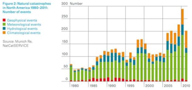
Troubling Trends. 14 separate billion dollar weather disasters in 2011, at least 11 more in 2012. Graph: Munich Re and NatCatSERvice.
With Climate Change, Winter Isn't What It used To Be. Here's an excerpt of an article at The Seattle Times: "...One of the biggest surprises in the technical report on biodiversity and ecosystems is how much winter has already changed, said Bruce Stein, director of climate-change adaptation with the National Wildlife Federation, in a conference call this week. "The bottom line is that these impacts aren't just going to happen in 50 to 100 years; many of them are already here, and are only going to get worse over time," Stein said. "There has already been more effect on winter than we thought, and that affects what happens in summer." In the Northwest, forests already show the effect of warmer winters in beetle-killed trees. The pests thrive without the killing cold. That, in turn, means summertime wildfires stoked with dead conifers..."
(Photo above: "mikepic")

1. Extend emissions limits to cover existing power plants.
On Dec. 20, a federal appeals court upheld that the Environmental Protection Agency has the power to regulate greenhouse-gas emissions. With its regulatory authority better established, the next step for the EPA could be to extend its emissions limits to cover existing power plants, not just new ones..."