Christmas Perspective
As our winters slowly warm, with more fickle
snowfall patterns showing up from year to year, it's good to keep some
perspective. Yes it's chilly out there, but nothing like 1983, when the
"high" on Christmas Eve was -10F.
Santa was not amused.
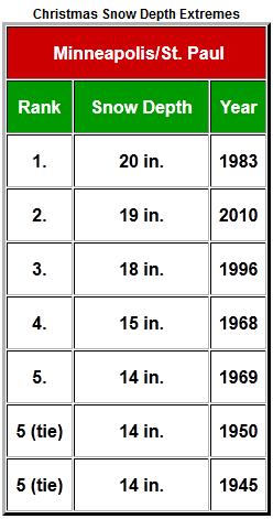
That was the year we had 20 inches of snow on
the ground on December 25 and then went on to pick up 98.6 inches for
the winter. Back when it snowed fairly consistently.
NWS records show 19 inches on Christmas 2010, 18
inches in 1996; both real winters. The exceptions to the rule. It's
odd: December's the snowy canary in the winter coal mine. If we get
smothered in snow - expect a long, old fashioned Minnesota winter.
But El Nino & nagging drought are conspiring
to route storms south/east of home - a trend that will continue thru
the first week of January.
Flurries are possible today (metro coating, 1-2"
far western MN), maybe a Friday coating, but holiday travelers in the
Upper Midwest catch a big break. Meanwhile the southern and eastern US
get pummeled with heavy rain and T-storms. Details below.
We may wake up to readings near zero Christmas morning - cold enough for most of us.
1 inch of snow on the ground Christmas morning? More beige than white.
Santa Tracker. Hey, it's a Christmas tradition.
Click here
to track Santa's real-time GPS location, in a variety of languages. I
don't expect any weather-related delays. Nobody does it better than
NORAD.
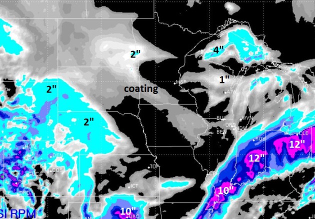
72 Hour Snowfall. A combination of mid-December
warmth (and rain) has chewed away at our snow cover, down from 11" on
December 10 to a paltry inch as of December 23 in the Twin Cities. A
coating of snow is possible south/west of the Minnesota River today,
closer to 2" near Fargo/Moorhead. A Wednesday storm may dump as much as
10" of snow from Oklahoma City to Evansville, Indianapolis, Columbus and
Cleveland. If you're traveling into the Ohio Valley or the Northeast
immediately after Christmas you may run into weather-related issues. RPM
model above: WSI.
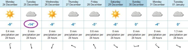
Christmas Day: Coldest Day In Sight. We won't set
any records, and (locals) probably wouldn't qualify Tuesday as "bitter",
but it will be cold enough, temperatures holding in single digits
across most of the metro area. We thaw out slightly, a shot at freezing
Sunday and Tuesday of next week. ECMWF highs above in Celsius (thank
God).
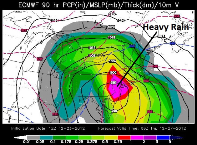
Wednesday Rainstorm For Northeast. Yes, it's a bit
odd tracking (mostly) rain for the northeast and New England in late
December, but that's the kind of winter we're having. The ECMWF model,
valid Wednesday at midnight, shows heavy rain pushing into Philadelphia
and New York City, with a potential for minor flash flooding (and flight
delays). Map: WSI.
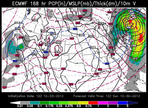
Weather Trends: Storms Buffeting Deep South and East Coast.
The ECMWF model above, valid Sunday morning (WSI) shows yet another
storm sweeping up the east coast, mostly rain for the major population
centers, but a changeover to heavy wet snow over New England. Boston may
pick up a few inches of wet snow from the system next Sunday/Monday,
while Minnesota warms up to near freezing.
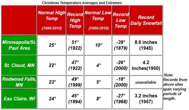
Christmas Numbers.
The average high for Christmas Day is in the low to mid 20s across most
of southern and central Minnesota. Climate info courtesy of the Twin
Cities
National Weather Service.
Very White Christmases. NWS historical data shows a whopping 20" on the ground back in 1983, 19" as recently as 2010.
Biggest Minnesota Weather Stories of 2012? Here is an excerpt from a recent post by Greg Spoden and Pete Boulay at
The Minnesota Climatology Working Group:
#5 Non-Winter of 2011-12
Some of the predictions were dire. Possibly a winter more snowy than
2010-2011 was in the cards. It didn't happen. One of the most wimpy
winters ever seen in the Twin Cities and Minnesota was the result with
mild temperatures and scant snowfall. 2011-12 wound up the tenth least
snowy winter on record for the Twin Cities and was the fourth warmest
winter on record.
#4 Hot July 2012
2012 was the second warmest month ever for the Twin Cities back to
1872 with 80.2 degrees. Only July 1936 was warmer with 81.4 degrees.
Duluth had its warmest July on record, although in 1936, the recording
station for Duluth was closer to Lake Superior. To escape the heat,
one had to go to International Falls where the average July
temperature was 69 degrees making 2012 only the 12th warmest July on
record there.
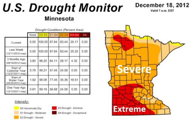
#3 Drought of 2011-2012
This could easily be #1 depending on where you live in Minnesota. The
heavy rains of May and June, 2012 helped to blunt the drought a bit,
but then it intensified by the late summer and continued into the
fall. By late November 80% of the state was under a severe or extreme
drought. By fall, soil moisture levels at the University of Minnesota
Southern Research and Outreach Center in Waseca were some of the
lowest on record.
#2 Northeast Minnesota Flood of June 19-20
The largest flash flood event in Minnesota for 2012 struck northeast
Minnesota on June 19-20. The largest two day total was 10.10 inches
just northeast of Duluth. There were so many roads flooded out in
Carlton County that the county rain out of signs and more had to be
trucked from the Twin Cities. One of the iconic photos of the storm was
of Feisty the seal who escaped the Lake Superior Zoo and wound up on a
neighborhood street. The St. Louis River engulfed and nearly
destroyed the Jay Cooke State Park Swinging Bridge, but it will reopen
in the summer of 2013. As for Feisty? She found refuge at Como Zoo
and now has over 800 followers on
Twitter.
#1 Outrageously Mild March 2012
Imagine if you will a March that was so warm it would break six
record high temperature records in the Twin Cities, have four days with
muggy dew point temperatures that reached 60 and wound up warmer than
October! To top it off the Twin Cities had its earliest 80 degree
temperature ever with 80 degrees on St. Patrick's Day, March 17. The
old record was March 23 back in 1910. March 2012 will go down in
history as one of the most bizarre months temperature-wise, finishing
15.5 degrees above normal. The only other month in the historical
record for the Twin Cities that matches this feat was January 2006 that
also finished 15.5 degrees above normal. As a consequence, spring
phenology was exceedingly early with lilacs blooming the earliest on
record in the Twin Cities, with many in full bloom by mid April.
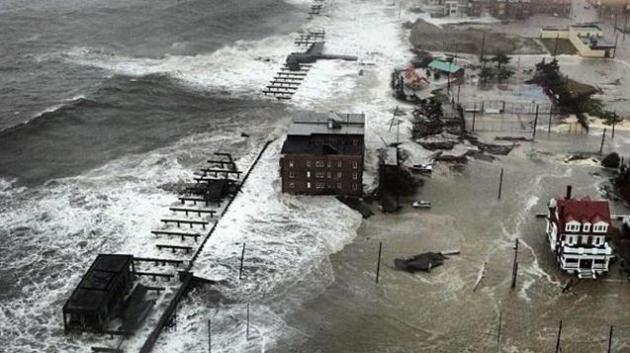
Sandy Timeline.
Gizmodo.com
has one of the better chronological summaries of Superstorm Sandy,
including some of the most incredible (and harrowing) photos of the
aftermath I've seen yet. Here's an excerpt: "This time it was no hype.
Sandy rampaged through New York, New Jersey and the rest of the
Northeast. The damage has been enormous: more than a hundred dead,
massive flooding everywhere, collapsed buildings, generator
malfunctions in hospitals, multiple fires, city-wide blackouts and
explosions in power plants. This is the complete story of Sandy, one
week later—a chronological timeline."
Hurricane Sandy: "
the largest Atlantic hurricane on record in terms of wind span". Source: Swiss Re (article at
desmogblog.com).
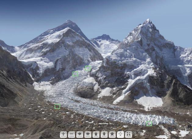
A 3.8 Billion-Pixel Tour Of Mt. Everest. This is pretty amazing; definitely worth a look. Here's an excerpt from
NPR: "
Photographer David Breashears of GlacierWorks
was on All Things Considered Monday to talk about a new way of
photographing the Himalayan region: By stitching together 400-plus
images into one giant, zoomable, interactive image — or a "gigapan"
containing more than a billion pixels. He and his team just sent us
something even cooler that they're currently working on: a Mount Everest you can explore, containing an estimated 3.8 billion pixels!"
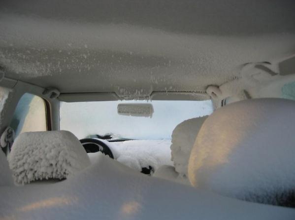
Nice Interior Trim. Thanks to airjokeroo.com for passing this one along. Looks like someone forgot to roll up their windows. Ouch.
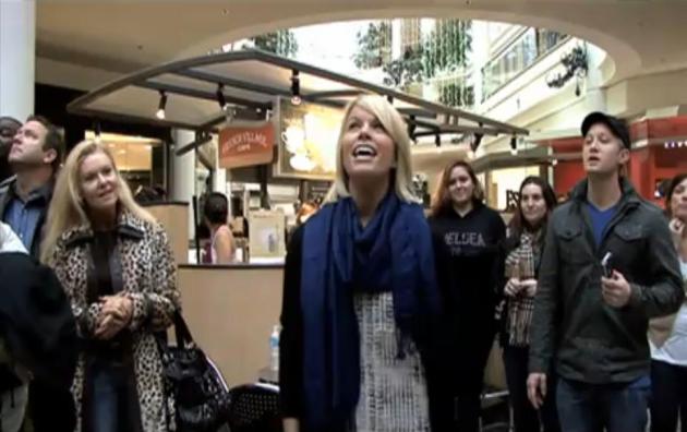
The Real Spirit of Christmas. It's easy to get
caught up in your "December Bubble", running around, focusing on gifts,
relatives, cooking, reunions. You should check out this
YouTube clip, apparently shot at the Mall of America recently. If you don't have the holiday spirit - you will after watching this.
Climate Stories...
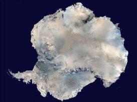
Western Antarctic Warming Confirmed. Contrary to the climate denier meme that "Antarctica is getting colder!"
USA Today reports; here's an excerpt: "
Western
Antarctica has warmed unexpectedly fast over the last five decades,
weather records confirm, adding to sea-level rise concerns in a warming
world. Temperatures in West Antarctica have increased at a rate nearly
twiceas large as the global average, a 4.3 degree Fahrenheit increase
since 1958, conclude meteorologists in the journal, Nature Geoscience,
out Sunday.The finding adds Western Antarctica to the list of hot spots
most affected by global warming, the century-long increase in global
average temperatures largely driven by greenhouse gas emissions from
burning oil, gas and coal..."
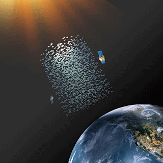
Harvard Scientist Proposes Refreezing Arctic To Prevent Global Warming Disaster. Not sure this is a great idea - I hope we never reach the point where this is deemed a necessity.
Mashable reports; here's an excerpt: "
Harvard
University geoengineer and environmental scientist David Keith has a
"plan B" in case of an environmental emergency. Keith's unusual proposal
is this: Force reflective particles into the Earth's upper atmosphere
-- the stratosphere -- to reverse global warming. "One approach is to
disperse particulates at high altitude to reduce the effective solar
flux entering the atmosphere," Keith and his fellow researchers report
in the Nature Climate Change journal and Environmental Research Letters..."
Image above:
coolsydney.net.au.
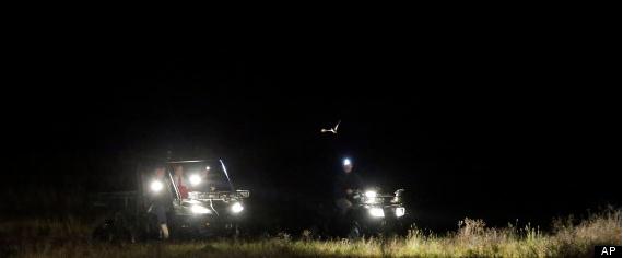
Texas Bird Count Gives Scientists Alarming Climate Change Clues.
Huffington Post has the story - here's an excerpt: "...
Similar
changes in bird behavior could be seen this year in the Midwest and
parts of the South, areas that have been gripped by a massive drought
that covered two-thirds of the nation at its height. The drought's
severity is unusual, but scientists warn that such weather could become
more common with global warming. Birds — as well as other animals —
will have to adapt, and the data collected in the Christmas count gives
crucial insight on how they might do that. The dataset is notable for
its size and the decades that it covers. Along with showing how birds
adapt to climate change, it reveals the impact of environmental
changes, such as habitat loss, which has contributed to a 40 percent
decline in bird numbers during the past 40 years, said Gary Langham,
vice president and chief scientist for the National Audubon Society..." (Photo above: AP)
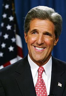
"...America's contributions to global climate change and our oil
dependence are endangering our national security, our economy and our
environment. But the global climate crisis is more than an urgent
scientific emperative; it is also a tremendous economic opportunity to
secure America's leadership in creating the low-carbon global economy
and our future prosperity..."
- Senator Bob Kerry, quoted in an article at
Ars Technica. Image: Wikipedia.
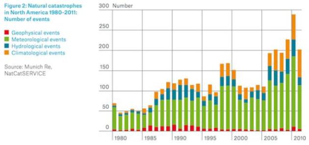
Troubling Trends. 14 separate billion dollar weather disasters in 2011, at least 11 more in 2012. Graph: Munich Re and NatCatSERvice.
With Climate Change, Winter Isn't What It used To Be. Here's an excerpt of an article at
The Seattle Times: "...
One
of the biggest surprises in the technical report on biodiversity and
ecosystems is how much winter has already changed, said Bruce Stein,
director of climate-change adaptation with the National Wildlife
Federation, in a conference call this week. "The bottom line is that
these impacts aren't just going to happen in 50 to 100 years; many of
them are already here, and are only going to get worse over time,"
Stein said. "There has already been more effect on winter than we
thought, and that affects what happens in summer." In the Northwest,
forests already show the effect of warmer winters in beetle-killed
trees. The pests thrive without the killing cold. That, in turn, means
summertime wildfires stoked with dead conifers..."
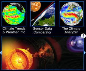
An Apps-Eye View Of Global Warming And Climate Change. Here is an excerpt of a good review of a few climate change related apps you can download for IOS and Android from
MercuryNews.com: "
Drought
in the Midwest; forest fires in the Southwest; blizzards and
hurricanes on the East Coast; rising ocean levels on both coasts. If
you're wondering what to make of the crazy weather of the past few
years, maybe it's time to check out some of the iPhone and Android apps
you can use to study climate change and global warming. Quite a few
are devoted to the still-contentious issue. Many are for the Apple (AAPL)
operating system, but there are some in the Android app store too. By
making the science visual, some of these apps let the nonprofessional
see historic trends without having to wade through thousands of
spreadsheets and databases..."
Your 2012 Climate Change Scorecard. Grist tallies up the pluses and minuses for 2012; here's an excerpt: "
As our friends at 350.org like to remind us, climate change really comes down to math.
Put x amount of greenhouse gas in the atmosphere, see y degrees of
warming. Our goal — meaning, our goal as an evolved, aware species that
would rather not be plagued by droughts and megastorms and constant
flooding and armed conflict — is to reduce how much carbon dioxide
we’re putting into the atmosphere each year instead of continually
increasing the amount. We’re not good at this. And time is running very
low: We either need massive, quick action or it’s too late.
Given that this particular year is nearing its end, we decided to
figure out how the math for 2012 stacked up. Did we, on balance, change
our ways so that our net greenhouse gas emissions declined, or did we
yet again increase how much we’re polluting? Are we running in the
positive or the negative or what?..."
(Photo above: "mikepic")
Four Feasbile Ways Obama Can Work On Climate Change. Here's a snippet from a recent
Bloomberg article: "
As the president looks toward his second term, he has pledged that climate change will be one of his top three priorities.
Given that a carbon tax or cap-and-trade program still seem to be
remote possibilities, what else can be done? Here are four plausible
policy options.
1. Extend emissions limits to cover existing power plants.
On Dec. 20, a federal appeals court upheld
that the Environmental Protection Agency has the power to regulate
greenhouse-gas emissions. With its regulatory authority better
established, the next step for the EPA could be to extend its emissions
limits to cover existing power plants, not just new ones..."