8" rain reported in parts of central and southern Maine over the weekend, over 7" reported at Portland, Maine.
98 F. high at Salt Lake City, Utah Monday, breaking the old record of 96 F in 1988. Source: NOAA.
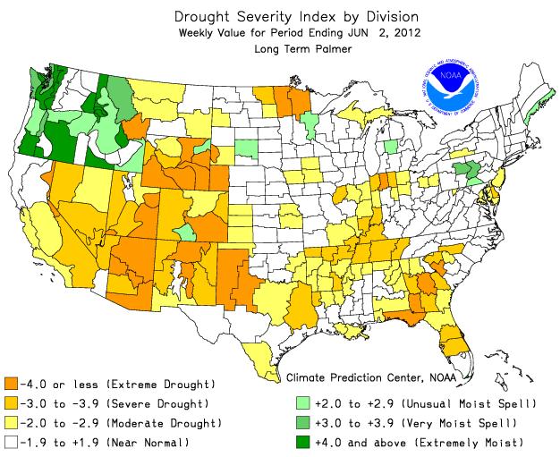
Palmer Index. Here is a running tally of moisture
conditions across the USA. The Red River Valley is still running a 4"+
rainfall deficit, but parts of central and east central Minnesota are
showing a 2-3" rainfall surplus, for the first time all year. Palmer
Index courtesy of
NOAA.
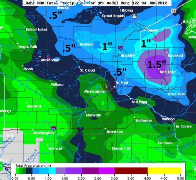 84 Hour Rainfall Prediction
.
After
a dry day today (make the most of it) an approaching warm frontal
boundary will leave the atmosphere irritable, capable of a few T-showers
Wednesday, with a possibility of stronger T-storms Thursday and Friday.
The heaviest (.5 to 1.5") rainfall amounts are forecast to fall
north/east of the Twin Cities.
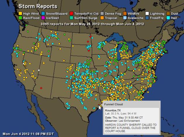
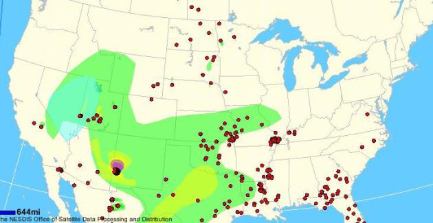
The United (Stormy) States of America. This
interactive Ham Aeris map shows the last week's worth of severe storm reports from coast to coast, over 3,000 at last count.
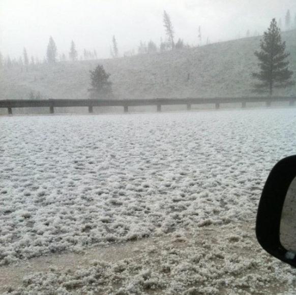
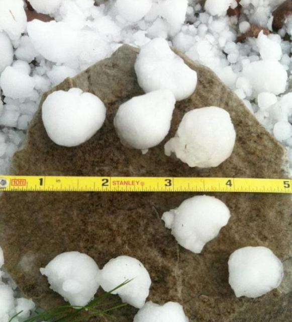
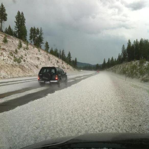
Montana "Hailers". National Weather Service
employees captured these photos of 1-2" hail, which covered the ground
near Potomac, Montana on Monday. Photos via
Facebook.
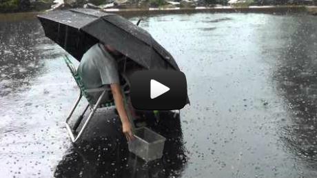
That's One Way To Collect Hail. Thanks to
max099tube for showing us the proper way to collect penny-size hail in Lehigh Valley, Pennsylvania on Sunday. A funny YouTube clip is
here: "
Zaxk having fun in the rain and hail."
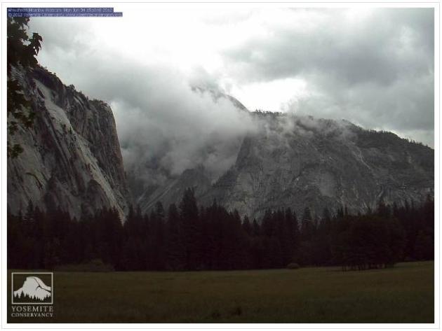
A Threatening Sky. Thanks to the Yosemite Conservancy for sharing this photo taken yesterday.
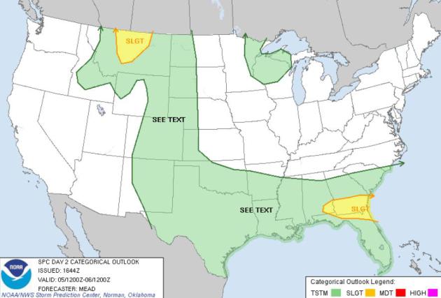
Tuesday Severe Risk. A few storms may exceed severe
criteria (1" diameter hail and winds over 58 mph) in northern Montana,
southern Georgia and the Florida Panhandle, according to NOAA SPC.
Outlook: Smoky Sunsets? NOAA's
"Fire Detect" URL
shows the location of every active wildfire in the USA, as well as
resulting smoke plumes. As hot air pushes north late in the week I
wouldn't be surprised to see a few extra-red, smoky sunsets across
Minnesota and much of the Upper Midwest.
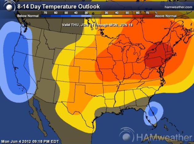
Warming Trend. The extended 8-14 day outlook from
CPC (NOAA's Climate Prediction Center) shows a significant warming from
the Upper Midwest into New England through mid-June.
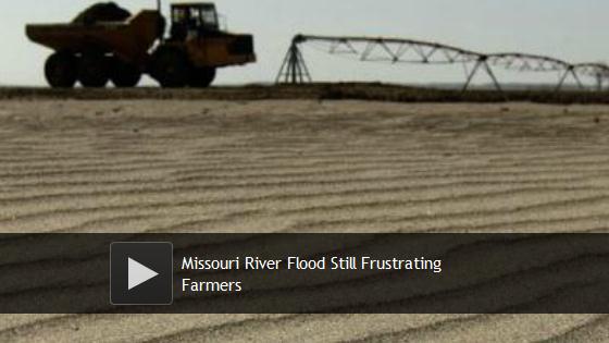
Missouri River Flooding: Sand Poses Major Problem For Farmers (Photos). Here's a snippet from
The Huffington Post: "
MISSOURI
VALLEY, Iowa (AP) — Mason Hansen guns his pickup and cranks the
steering wheel to spin through sand up to 4 feet high, but this is no
day at the beach. Hanson once grew corn and soybeans in the sandy
wasteland in western Iowa, and his frustration is clear. Despite months
spent hauling away tons of sand dropped when the flooded Missouri River
engulfed his farm last summer, parts of the property still look like a
desert. Hundreds of farmers are still struggling to remove sand and
fill holes gouged by the Missouri River, which swelled with rain and
snowmelt, overflowed its banks and damaged thousands of acres along its
2,341-mile route from Montana through North Dakota, South Dakota,
Nebraska, Kansas, Iowa and Missouri. The worst damage and the largest
sand deposits were in Iowa and Nebraska."
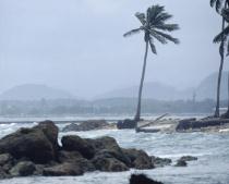
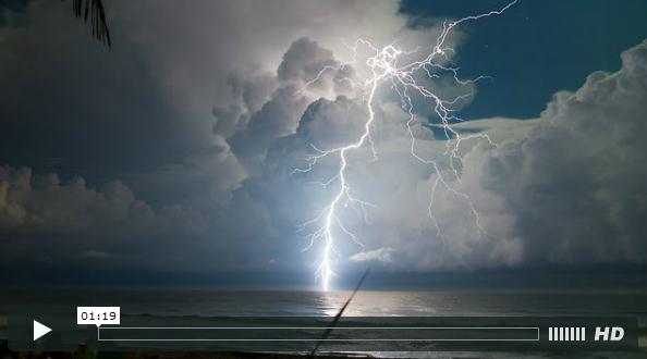
Hurricane Forecast For 2012: Cloudy With Chance Of Landfall.
I have this nagging gut feel (nausea?) that it's going to be an
above-average summer and autumn for hurricanes impacting the USA. I hope
I'm wrong. Here's an excerpt of a story at
Property Casualty 360: "
The
Atlantic Hurricane Season starts this week, and forecasters are
calling for a normal number of storms—but some warn that the odds are in
favor of a U.S. landfall. Catastrophe-modeler RMS released its
pre-season commentary, saying conditions remain right for the total
number of tropical storms “to be near the long-term average of 10.7
tropical storms.” RMS notes that while some existing conditions could
drive higher Atlantic basin-activity, other factors, such as higher
wind shear over the Atlantic, have increased “the likelihood of a
near-normal season in 2012.”
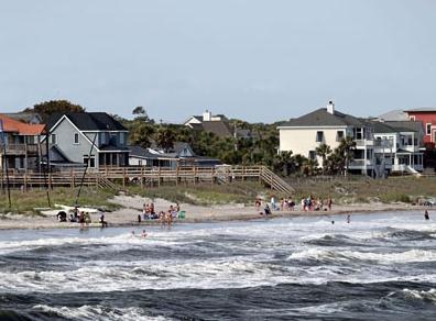
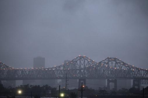 Officials: New Orleans Ready For Hurricanes
. I hope those officials are right; here's an excerpt from
Insurance Journal: "
The
Army Corps of Engineers — responsible for the massive rebuilding of
hurricane protection after the devastation of Hurricane Katrina in 2005
— and leaders from around the metropolitan area say they’re working
closely on emergency planning as the new hurricane season officially
gets under way June 1. With billions of dollars invested in new levees,
floodwalls and other flood protection, and an overhaul of cooperative
emergency planning that emerged from the Katrina disaster, officials
say citizens should have greater confidence that if tropical weather
sweeps out of the Gulf of Mexico this year the systems and
infrastructure in place are up to the test."
Photo credit: AP Photo/Gerald Herbert.
Storm Of Money: Hurricanes, Insurance And The Secret Black Boxes That Make Our Rates So High. Wonder why your insurance rates are so high? Charleston's
Post and Courier has a must-read article; here's an excerpt: "
Some
things are certain: As the earth spins, air moves swiftly around the
equator, creating the trade winds. It’s also certain that storms will
form because the sun shines bright where these trades blow, turning sea
water into sky-high clouds of steam that inevitably collapse, a
process announced by torrents of rain and thunder. And we know for sure
from history and physics that a few of these air masses will spin
counterclockwise, slowly at first, then faster and with enough momentum
to flatten cities, alter destinies, and if hooked into some fantastic
electric grid, pack enough energy to light every bulb on earth."
Photo credit: Post and Courier.
"Ask Paul". Weather-related Q&A.
Paul,
"
The last three years have been brutal for insurance companies
writing business in Minnesota due to the severe weather. Do you think
our current weather patterns are here to stay, ie, get used to it?"
Thank you,
Kevin Burkholder
Vice President - Personal Lines
RAM Mutual Insurance Company
Kevin - great question. The trends are pretty convincing in
the severe weather department. Dr. Jeff Masters at Weather Underground
believes the last 2 years have been the most severe for the USA since
1816. We're seeing more extreme weather events, more hail and more
downpours, in fact, the number of severe, 3"+ downpours across the Upper
Midwest has doubled in the last 50 years. There's no strong link (yet)
between climate change and tornadoes, but there's little doubt that
excessive rainfall events are on the rise, probably hail too, and this
pattern will almost certainly accelerate as we pump more greenhouse
gases into the atmossphere in the years ahead.
________________________________________________________________________________
Hello Paul,
"I just wanted to hear your opinion and ask
you a question. I don't know if it's "Ironic", but you mention in your
blogs that warmer atmosphere holds more water. Since this was the
warmest spring, doesn't it still link to this 2nd wettest spring since
it was warmer?"
Thanks,
Israel
Israel -
there's little doubt in my mind that warmer = wetter (and more severe). A
warmer atmosphere can hold more water vapor, loading the dice in favor
of more (extreme) rainfall events, and that's what we're seeing in the
data. Spring of 2012 was the warmest, and second wettest on record. 2010
was Minnesota's wettest year - and brought the most tornadoes the state
has ever witnessed (145). I've been accused of being an "alarmist", but
if you step back and really look at the trends, they are a bit
alarming.
In A Skirmish To Control The Screens. Here's an excerpt of an interesting article from
The New York Times: "
Given
the relentless battles by tech companies to win new smartphone users,
you would think that the tiny screen is the only one that matters.
Those battles are part of a larger war for three screens: smartphones,
tablets and televisions. The most important facet of these devices
won’t be the sharpness of the display or the sleekness of the design —
they will, after all, essentially be the same: flat pieces of glass of
varying sizes. What we will want most from these screens is their
ability to communicate with one another like a group of gabbing
teenagers in the middle of school recess."
Camping Storm Safety
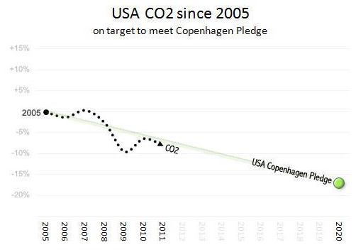
Here's a rare nugget of good news on the climate
front: the International Energy Agency (IEA) reports that the USA cut
greenhouse gas CO2 emissions by 430 million tons (7.7%) since 2006. The
bad news: global CO2 levels reached a new high in 2011 (31.6 gigatons).
Details on the blog.
So what?
A warmer atmosphere holds more water, loading the dice in favor of more severe storms and flash floods.
What do you do if a severe thunderstorm
approaches your campsite? Situational awareness is crucial. With
portable NOAA Weather Radios and apps on smart phones there's no reason
why you have to be surprised by storms. True, you may not get a great
cell signal up in the BWCA.
Your vehicle offers more protection than a soggy
sleeping bag. Are there restrooms nearby? Better than nothing. The
danger is lightning and falling trees - so try to find an outcropping of
rocks to ride out the storm.
A dry, quiet Tuesday gives way to a slight
thunder risk Wednesday; a better chance of storms Friday as hot,
humidifed air pushes north.
You'll want to evacuate to your favorite lake - highs reach the 90s Saturday and Sunday with dew points in the 70s.
A 100 F. heat index? We'll come close.
Climate Stories....
 Climate Scientists Lament A Nation Stuck On The Wrong Debate
. Here's an excerpt from a story at
insideclimatenews.org: "
The
global warming debate in Congress, the states and on the campaign
trail centers on two issues: Is Earth warming, and if so are humans to
blame? But ask most climate scientists, and they'll tell you that these
are the only questions not in dispute. Climate change is a matter of how
bad and by when, they'll say—not whether. "Scientists are inherently
skeptical," says Lonnie Thompson,
a paleoclimatologist at Ohio State University, who has led studies of
glaciers and ice sheets in 16 countries. "After enough evidence and
observation, though, you have to start to accept findings. That is what
happened with climate change. This wasn't a rash conclusion."
Photo credit above:
"NASA
scientists study changing conditions in the Arctic as part of the
agency's ICESCAPE mission, or Impacts of Climate on Ecosystems and
Chemistry of the Arctic Pacific Environment/Credit: NASA, Kathryn Hansen.
Climate Change Stunner: USA Leads World In CO2 Cuts Since 2006.
Here's a bit of good news - not sure how much of this CO2 reduction was
a symptom of the recession/depression we just muddled through, but the
Vancouver Sun has a ray of good news; here's an excerpt: "
The
world has yet to figure out how to stop the relentless increase in
climate pollution. But mixed in with all the bad news there was one
shining ray of hope. One of the biggest obstacles to climate action may
be shifting. As the IEA highlighted:
"US emissions have now fallen by 430 Mt (7.7%) since 2006, the largest reduction of all countries or regions.
This development has arisen from lower oil use in the transport sector
… and a substantial shift from coal to gas in the power sector."
How big is a cut of 430 million tonnes of CO2? It's equal to all
CO2 from all Canadians outside Alberta. From a US perspective, it's
equal to eliminating the combined emissions of ten western states:
Alaska, Washington, Oregon, Idaho, Montana, North Dakota, South Dakota,
Wyoming, Utah and Nevada."
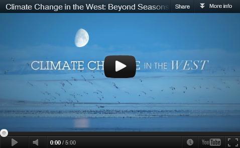
Beyond Season's End: Sportsmen Concerned About Climate Change.
Many farmers and fishing and hunting enthusiasts have told me stories
about changes they're witnessing, literally out in the field, with their
own eyes. It's a slow-motion transformation, but that northward shift
in flora and fauna climate scientists were predicting 30 years ago? It's
happening. Here's a post from
Climate Denial Crock of the Week: "
Rising summer temperatures pose a threat to coldwater brook trout in the Adirondacks, a recent study shows.
Researchers recorded air and water temperatures over the course of 11
summers and correlated readings to spawning activity. A rise of 1.8
degree Fahrenheit delayed spawning by approximately one week and reduced
the number of nests. Late spawning is likely to delay the emergence of
fry, which could uncouple synchronicity with the emergence of prey.
Water temperatures near 70 degrees Fahrenheit stress the fish, which do
not have sufficient energy to feed. Consequently the growth of their
reproductive organs slowed. High temperatures effectively caused the
trout to shut down in the middle of the summer, the paper’s authors
said."
The Planet Wreckers: Climate-Change Deniers Are On The Ropes - But So Is The Planet. Here's an Op-Ed from Bill McKibbon at
Huffington Post: "
It’s
been a tough few weeks for the forces of climate-change denial. First
came the giant billboard with Unabomber Ted Kacynzki’s face plastered across it:
“I Still Believe in Global Warming. Do You?” Sponsored by the
Heartland Institute, the nerve-center of climate-change denial, it was
supposed to draw attention to the fact that “the most prominent
advocates of global warming aren’t scientists. They are murderers,
tyrants, and madmen.” Instead it drew attention to the fact that these
guys had over-reached, and with predictable consequences. A
hard-hitting campaign from a new group called Forecast the Facts persuaded many of the corporations backing Heartland to withdraw $825,000
in funding; an entire wing of the Institute, devoted to helping the
insurance industry, calved off to form its own nonprofit. Normally
friendly politicians like Wisconsin Republican Congressman Jim
Sensenbrenner announced that they would boycott the group’s annual
conference unless the billboard campaign was ended."
Global Warming And Hurricanes. Here's a snippet of a story at the
Grand Cayman Observer: "
Although
there is a strong consensus among scientists that human-induced carbon
dioxide emissions are causing a greenhouse effect and thus raising
surface temperatures on Earth, other scientists staunchly oppose the
idea. One of those opposing scientists is
William Gray, a meteorologist who pioneered seasonal hurricane
forecasts while working at Colorado State University, where he remains
professor emeritus of atmospheric science. Among
his theories based on his scientific observations, Gray doesn’t
believe that carbon dioxide emissions are having any measurable effect
on the formation of tropical cyclones. "
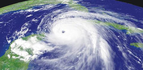
* image of Hurricane Ivan above courtesy of NASA.
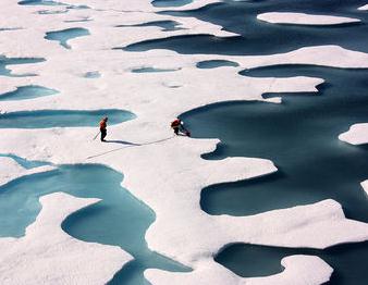
How Climate Change Is Growing Forests In The Arctic. Here's an excerpt of a story in
Time Magazine: "
If
there’s a single lesson for early 21st century life on the planet
Earth, it’s this: everything connects. That’s true whether we’re looking
at the global economic system, where sickness is now spreading from
the Euro zone to China to a wobbly U.S.,
or the global environment, as we can see in a new study showing the
Arctic rapidly responding to climate change by sprouting sudden trees in
the tundra. Researchers in Britain and Finland studied an area of
38,600 sq. mi (100,000 sq. km) in what’s known as the northwestern
Eurasian tundra, which stretches from western Siberia to Finland."
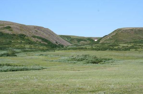
Photo credit above: B.C. Forbes. "
Growing shrubs in the Arctic of western Siberia."
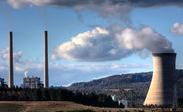
Nuclear, Coal Power Face Climate Change Risk - Study.
Reuters has the story; here's an excerpt: "
SINGAPORE,
June 4 (Reuters) - Warmer water and reduced river flows will cause more
power disruptions for nuclear and coal-fired power plants in the United
States and Europe in future, scientists say, and lead to a rethink on
how best to cool power stations in a hotter world. In
a study published on Monday, a team of European and U.S. scientists
focused on projections of rising temperatures and lower river levels in
summer and how these impacts would affect power plants dependent on
river water for cooling. The authors
predict that coal and nuclear power generating capacity between 2031 and
2060 will decrease by between 4 and 16 percent in the United States and
a 6 to 19 percent decline in Europe due to lack of cooling water."