90-Day temperature outlook calls a hotter than average summer for much of the USA. The CPC/Ham Weather prediction below.
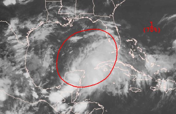
"Debby" may be forming in the Gulf of Mexico - NHC
now predicts a 70% probability of tropical storm formation. Details
below. Enhanced IR loop courtesy of WSI's
intellicast.com.
Corpus Christi:
the ECMWF (European) model brings "Debby" ashore near Corpus Christi,
Texas next Thursday. Confidence level is (very) low; that track will
almost certainly change in the coming days. Details below.
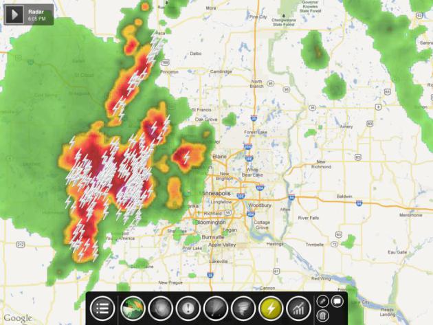
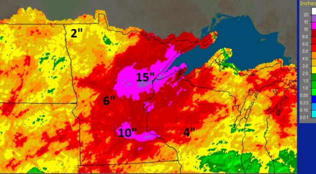
Off The Charts. The
NOAA map
above shows Doppler radar rainfall estimates for the last 30 days; over
15" near Duluth, and just southeast of MSP, from Cannon Falls to
Hastings. Meanwhile moderate drought conditions linger over Minnesota's
Red River Valley.
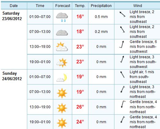
Weekend Details. The ECMWF model suggests the best
chance of a weekend shower or T-shower will come Saturday morning.
Sunday still appears to be the drier, sunnier day - winds shifting to
the north/northeast (fairly brisk, at 10-20 mph) with highs in the mid
80s.
Dew Point Prediction:
55 Today
59 Saturday
64 Sunday
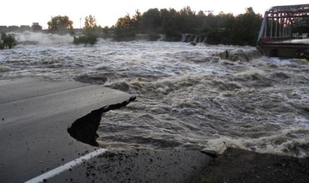
What Just Happened? 10" of rain in less than 48 hours? You might expect that in Manila or Fiji, but the North Woods of Minnesota? Details: "
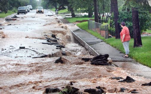
A
neighborhood resident looks at a flood-damaged road in Duluth, Minn.,
Wednesday morning, June 20, 2012. Torrents of rain and floodwater cut
away part of the roadbed. (AP Photo/Duluth News Tribune, Bob King)."
Washout. Wednesday morning small creeks were transformed into raging rivers, in a meteorological blink of an eye. Details: "
Railroad
crews inspect the flood damage to a section of track west of Duluth,
Minn.,Thursday morning, June 21, 2012. National Weather Service
meteorologist Kevin Kraujalis said 7.2 inches of rain fell on Duluth on
Tuesday and Wednesday, breaking the two-day record of nearly 6.7
inches set on July 20-21,1909. (AP Photo/The Star Tribune, Brian
Peterson)."
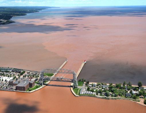
Serious Runoff. The amount of rainwater running off into Lake Superior is staggering. Details: "
Clay-laden
waters from the Duluth-Superior Harbor Basin pour out past the Aerial
Left Bridge, through the ship canal and into Lake Superior on Thursday
afternoon, June 21, 2012, in Duluth, Minn. Minnesota Gov. Mark Dayton,
who toured flood-ravaged areas on Thursday, said he was committed to
providing state resources, and would work to speed the process of
getting appropriate federal aid. Duluth's mayor, Don Ness, estimated
that there was $50 million to $80 million in damage caused to the
city's public infrastructure alone. (AP Photo/Duluth News Tribune, Bob
King)."
Northeastern Minnesota Flooding Information. Here is a good list of resources to keep up to date with what's happening in the Duluth area, courtesy of
HSEM, The Homeland Security and Emergency Management:
News Releases
Resources
Social Media
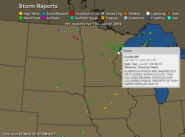
Storm Reports.
Ham Weather has more details on Wednesday's historic flooding up north. Data courtesy of NOAA.
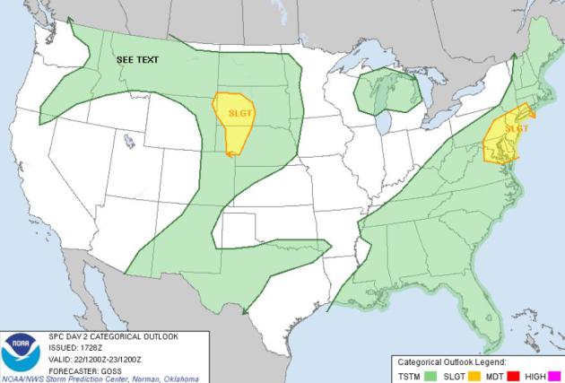
Friday Severe Threat. SPC is highlighting two areas
to watch later today: the Dakotas, and a heavily populated region in the
Northeast, from D.C. to Philadelphia, New York and Hartford - strong to
severe storms helping to break the heat as cooler, Canadian air sweeps
east.
Highway 210 Washed Away. Here's the latest from
MnDOT: "
New photo of HWY 210 near Carlton. The St. Louis River washed out HWY 210 leading up to the Thomson Bridge. Photo Courtesy of Minnesota Department of Transportation."
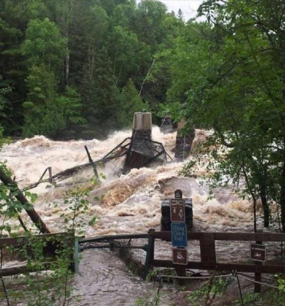
Swinging Bridge Is Gone. Leslie Munchho at Minnesota State Parks and Trails reports that Swinging Bridge is washed away at Jay Cooke. More via
Facebook.
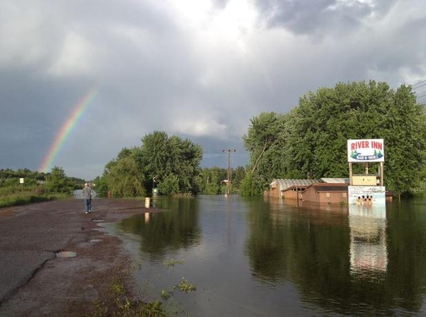
"After The Flood". Thanks to KARE-11's Boyd Huppert, who captured this shot near Scanlon - pic courtesy of KARE and
Facebook.
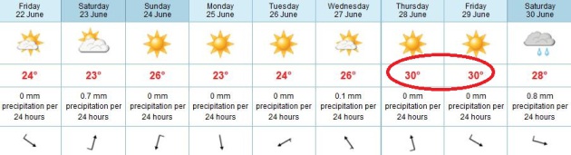
A Badly Needed Break. We should enjoy a dry pattern,
with near-normal temperatures through the middle of next week. The
European (ECMWF) model is suggesting low 90s returning by the end of
next week. High temperatures above in Celsius (you probably figured that
out).
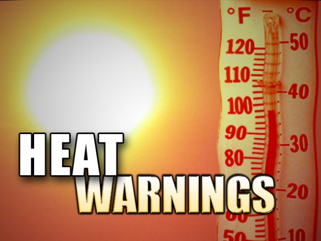
Thursday Records:
100 F. Baltimore (ties old record of 100 set in 1923).
99 F. Washington D.C. breaks old record of 98 set in 1988.
98 F. La Guardia, New York, breaking the old record of 97 in 1953.
96 F. Boston, breaking the old record of 95 (1949).
96 F. Hartford, tying old record of 96 set in 1953.
89 F. Bluefield, West Virginia (ties old record set in 2011).
99 F. Georgetown, Delaware, breaking the old record of 95 in 1964
97 F. Wilmington, Delaware, tying the (very) old record of 97 set in 1895.
89 F. Mount Pocono, tying the record of 89 in 1953.
95 F. Atlantic City, tying the record of 95 set in 2010.
97 F. Burlington, Vermont, breaking the old record of 95 set in 1953.
91 F. Worcester, Massachusetts ties the old record of 91 in 1953.
* records courtesy of NOAA and Earth Networks.
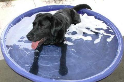
Dog Days Of June.
FEMA has some timely advice for overheated residents of the northeast:
"FloJo, a Search & Rescue dog, is staying cool today - are you? Safety tips for the summer heat:
- Check on those without air conditioning to make sure they're staying cool.
- Consider spending the warmest part of the day inside.
- Make sure your animals are not suffering from the heat and have plenty of water.
- Protect your face & head by wearing a wide-brimmed hat.
Leave a comment and share how you're staying cool! www.Ready.gov/heat."
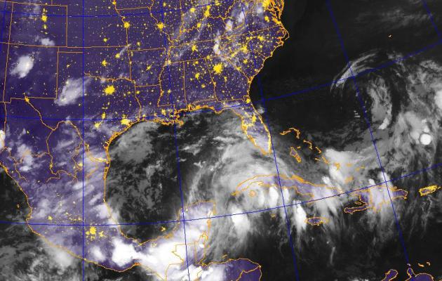
Watching The Gulf of Mexico. The swirl of moisture
in the eastern Gulf, centered just west of Cuba, shows signs of further
strengthening in the coming days. I have a strong hunch Tropical Storm
Debby will form in the Gulf of Mexico within 48 hours, posing the
greatest risk to Florida (but all residents living along the Gulf will
want to stay alert in the coming days). IR satellite image:
NEXSAT, Naval Research Lab.
Increasing Odds. 3 days ago the probability of
tropical cyclone formation was 10%. Yesterday it rose to 50%. As of late
last night the odds of cyclone formation with 48 hours rose to 70%. I
think Tropical Storm Debby is going to be a reality by late tonight or
early Saturday. More from
NHC:
A LARGE LOW PRESSURE SYSTEM LOCATED JUST NORTH OF THE NORTHERN COAST
OF THE YUCATAN PENINSULA IS PRODUCING AN EXTENSIVE AREA OF
CLOUDINESS...SHOWERS AND SCATTERED THUNDERSTORMS OVER MUCH OF THE
CENTRAL AND EASTERN GULF OF MEXICO AND THE NORTHWESTERN CARIBBEAN
SEA...AND ALSO OVER THE YUCATAN PENINSULA...WESTERN AND CENTRAL
CUBA...SOUTHERN FLORIDA...AND THE NORTHWESTERN BAHAMAS. SATELLITE
DATA AND SURFACE OBSERVATIONS INDICATE THAT THE LOW PRESSURE SYSTEM
IS GRADUALLY BECOMING BETTER DEFINED AND SURFACE PRESSURES ARE
SLOWLY FALLING ACROSS THE AREA. UPPER-LEVEL WINDS ARE ALSO
IMPROVING AND ARE FORECAST TO BECOME MORE CONDUCIVE FOR DEVELOPMENT
OF A TROPICAL DEPRESSION DURING THE NEXT DAY OR SO. THIS SYSTEM HAS
A HIGH CHANCE...70 PERCENT...OF BECOMING A TROPICAL CYCLONE DURING
THE NEXT 48 HOURS AS IT MOVES SLOWLY NORTHWARD INTO THE CENTRAL
GULF OF MEXICO. INTERESTS ALONG THE ENTIRE UNITED STATES GULF COAST
SHOULD MONITOR THE PROGRESS OF THIS LARGE DISTURBANCE THROUGH THE
WEEKEND. HEAVY RAINS AND LOCALIZED FLOODING ARE POSSIBLE ACROSS THE
YUCATAN PENINSULA...WESTERN CUBA...AND SOUTHERN FLORIDA THROUGH
SATURDAY. AN AIR FORCE RESERVE RECONNAISSANCE AIRCRAFT IS SCHEDULED
TO INVESTIGATE THE SYSTEM TOMORROW AFTERNOON...IF NECESSARY.
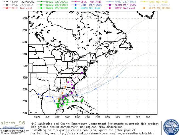
Place Your Bets. Steering winds aloft are unusually
light over the Gulf, which favors further strengthening, but makes
pinpointing a track even more difficult. Most of the models (above) seem
to favor a track over central or northern Florida, but a few models
bring Debby (?) into Texas. Stay tuned. Data courtesy of
sfwmd.gov.
* going way out on a limb, the ECMWF
brings
"Debby" ashore near Corpus Christi, Texas next Thursday. That track
will almost certainly change and shift in the coming days as new data
comes in. Residents of the Gulf should stay alert and consider hurricane
preparation plans well in advance.
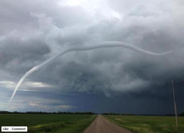
Photo Of The Day: Rope Tornado. I've never seen
anything quite like this - a skinny "rope" tornado that must stretch 2
miles from the cloud base to the ground. This was shared via the Grand
Forks NWS. Thanks to Matt Bahr from Valley News Live for sharing this,
via
Facebook.
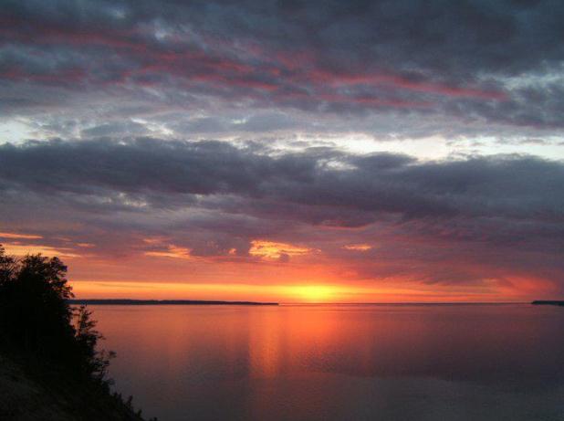
Honorable Mention. Here's a terrific shot from Sleeping Bear Dunes National Lakeshore, via
Facebook: "
The
beaches and viewpoints make the Port Oneida Rural Historic District
the perfect place to spend the Summer Solstice, official at 7:09pm EST.
Enjoy Summer 2012!"
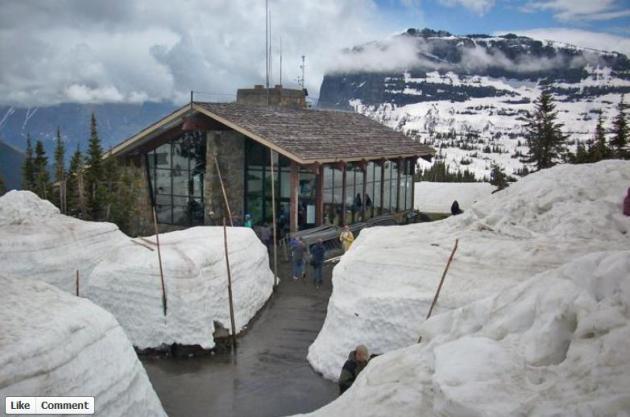
Opening Day - On June 20? Thanks to Glacier National Park. Opening day for the
Logan Pass Visitor Center was June 20, 2012. Yep, summer flies by at this altitude. Pic courtesy of Glacier National Park, via Facebook.
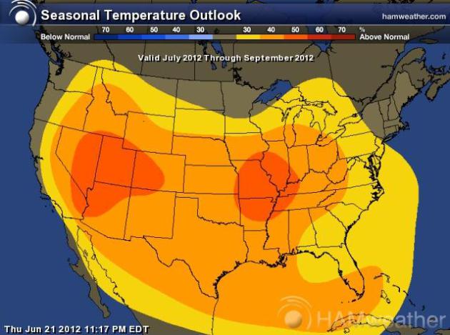
A Long Hot Summer?
CPC (NOAA's Climate Prediction Center) is predicting a hotter than
average summer for much of America, the best chance of sizzling heat
over the Intermountain Weset and the Middle Mississippi River Valley.
Map: Ham Weather.
Apps That Present Highlights Of The World In Front Of You.
It's called "augmented reality", and it's a fascinating new field; one
more app you may need for your smart phone. Here's an excerpt from an
article at
The New York Times (subscription may be required): "
Augmented
reality covers the many ways of adding digital information to the real
world around you, usually by adding on-screen flags to the video feed
from a smartphone’s camera. It’s clever and very futuristic, but you
can still try it out now easily. To identify the ship, for example, I
used a free app, Layar, which can pull in many different sources of augmented information. In my case it was data from Vesseltracker.com, which has up-to-date location information about ships in its database."
80.74 MPH - On A Skateboard? Please don't try this
at home - this guy is a trained professional (with the right equipment -
and a brand new life insurance policy).
Gizmag.com has the details: "
Traveling
at 80.74 mph (129.94 km/h) on four wheels won’t usually grab you a
Guinness world record, but when that feat is achieved on a vehicle that
relies on only leg power and gravity, it’s another story. That’s just
what 28-year old Mischo Erban has done in a record-breaking downhill
skateboard run at Les Éboulements in Quebec, Canada, this week."
Microsoft Unveils Windows Phone 8. I love my iPhone
(yeah, I'm an Apple fanboy), but this phone is...different, unique even.
I like the continuous updating panels on the home screen. More details
from
gizmag.com: "
Microsoft has certainly been keeping us all on our toes as of late, and just a couple of days after its big Surface
tablet reveal, the Redmond-based team are back in the headlines – this
time appearing at the Windows Phone Summit to spill the goods on
Windows Phone 8, due for release sometime in the final quarter of this
year. So what's new? Well, quite a lot actually."
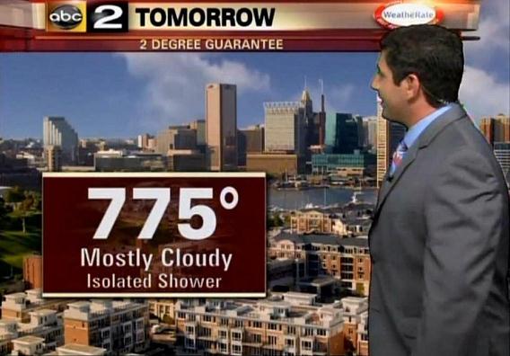
You Might Want To Avoid Baltimore Until Further Notice. I got a chuckle out of this, especially the "2 degree guarantee" part. 775F? Welcome to Venus!
TVSpy.com has the details of this unfortunate Chyron goof: "
The
majority of the country is in the grips of a heat wave right now, but
fortunately for Baltimore, it is not as hot there as a graphic on WMAR‘s
Sunday newscast (above) predicted it would be. “If you take a look at
tomorrow, temperatures will be into the 70s,” meteorologist Mike Masco said. “Not 775 degrees. That’s really a hot day.” [via Baltimore Media Blog]."
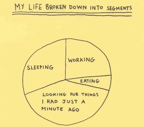
Sad, But True. The older you get, the more time you
(waste) looking for stuff you know you have, you just can't remember
where. Getting old sucks.
The 4 Stages of Life. O.K. I'm in a dark mood today - but this pic captured my interest (well into phase 3). One photo kind of sums it all up eh?
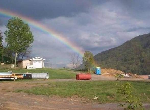
What's At The End of The Rainbow? An Outhouse. What happened to the pot of gold? It was replaced with a....pot.
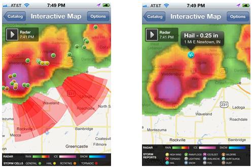
Mobile Storm Tracking. Screen Shots courtesy of Ham Weather. iPad display top left, iPhone storm-tracking top right.
Situational Awareness
I'm still getting grief about the Father's Day
forecast. Mea culpa. In my (feeble) defense, predicting hit-or-miss
summer T-storms is tough, some days futile. The models help, but they're
far from perfect. It's the atmospheric equivalent of predicting a
sneeze. Good luck with that.
Since you asked, the nationwide accuracy for a
24-hour forecast is 87 percent. I guess it's human nature to remember
the 13 percent of the time we "bust", especially on a weekend. For the
record: I wish my stock broker had an 87% track record.
The newspaper is a good place to start, but I
wouldn't dream of leaving the house on a weekend adventure without
checking radar (which I try to update on this blog). Better yet, load a
radar app on a smart phone, so you'll never be surprised on your
favorite lake. Weather is constantly changing, new data is always coming
in - the forecast is always changing based on the latest data fed into
supercomputer models. Those changes can be precariously fast during the
summer months. Enough said.
10.1" rain fell on Duluth in less than 48 hours
earlier this week. According to Mark Seeley DLH picked up 7.91 inches
over Aug 15-21, 1972. Baudette was soaked with 8-10" on June 9-10, 2002.
Unusual? Yes, but not unprecedented.
Fair weather lingers today. A stray T-storm Saturday gives way to more sun on Sunday; 90-degree heat returning late next week.
We may soon have Tropical Storm Debby in the Gulf of Mexico. Stay tuned.
Climate Stories...
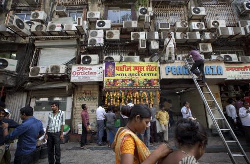
Air Conditioning: A Luxury The World Can't Afford. Here's an Op-Ed in
The New York Times
that caught my eye. Cooling and heating our homes and offices consumes
massive amounts of energy, with considerable waste and inefficiencies -
contributing to climate change. Here's an excerpt: "....
Cooling of
America's buildings and vehicles has the annual global-warming impact
of almost half a billion metric tons of carbon dioxide. (Three-fourths
of that is attributable to fossil fuels, the rest to refrigerants.)
We consume more energy for residential air-conditioning than do all
other countries combined, but that's about to change. Home-cooling
demand worldwide is projected to increase tenfold before 2050,
stimulated by rising incomes and rising temperatures in already-warm
regions. Such staggering growth will swamp out efficiency gains,
outstrip renewable energy and accelerate warming."
Photo credit above: "
Dozens of air conditioners line a
building wall in Mumbai, India, May 21, 2012. As use of one type of
environment-damaging gas used in air-conditioners is being phased out,
another is on the rise in developing economies where air-conditioner use
is exploding." (Kuni Takahashi/The New York Times)
How Do We Know Global Warming Is Not A Natural Cycle? A compelling video explanation from
Climate Central: "
How
do we know that today's global warming is not some natural climate
change cycle? Climate Central's Mike Lemonick explains. Watch science
made simple with this segment of his "Bowtie Series."
Study Predicts More Hot Spells In Southern California. The L.A. Times has the story - here's an excerpt: "
By
the middle of the century, the number of days with temperatures above
95 degrees each year will triple in downtown Los Angeles, quadruple in
portions of the San Fernando Valley and even jump five-fold in a portion
of the High Desert in L.A. County, according to a new UCLA
climate change study. The study, released Thursday, is the first to
model the Southland's complex geography of meandering coastlines,
mountain ranges and dense urban centers in high enough resolution to
predict temperatures down to the level of micro climate zones, each
measuring 2 1/4 square miles. The projections are for 2041 to 2060."
Photo credit above: "
Alex Hall, the UCLA study’s lead
researcher, says in addition to more very hot days between 2041 and
2060, the hottest of those days will break records."
(Christina House / For the Los Angeles Times / June 19, 2012)
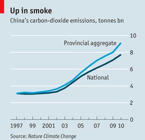
Warmed Up Numbers: China May Be Severely Under-Reporting Its Carbon Emissions. Here's an excerpt of an interesting article at
The Economist: "
FOR
those who live in China and are forced to breathe in its air every
morning, the findings of a recent report may come as no surprise, but to
climate analysts it will make for uncomfortable reading. According to a
new paper published in the journal Nature Climate Change,
China may be under-reporting its annual carbon emissions by as much as
1.4 billion tonnes a year—roughly the amount that Japan, the world’s
fourth-largest emitter of carbon dioxide (CO2), pumps out each year."
Graphic credit above: The Economist, Nature Climate Change.
How Government Funding Of Science Rewards U.S. Taxpayers.
One of my favorite shows on the tube right now is Fareed Zakaria's 360
Sunday show on CNN - this guy has a grasp on the world that few other
journalists have. Here is an excerpt of an Op-Ed he wrote for
The Washington Post: "
It’s
hard to find any good economic news these days. Europe is teetering on
the brink; emerging markets such as China, Brazil and India are
slowing down; and the United States is in a slump. There is one
bright spot on the American landscape: technology, particularly
biotechnology. The cost of sequencing a human genome is down to $1,000,
and the process now takes two hours — a pace that is much faster than
“Moore’s Law,” which says that computing power doubles while its costs
drop by half every 18 months."
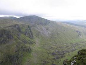
Scientists: Climate Change Is Causing Decline Of Specialized Plant Species.
Phys.org has the story; here's an excerpt: "
Research
funded by Scottish Natural Heritage (SNH) and the Natural Environment
Research Council (NERC) has revealed for the first time the impacts of climate change
on mountain landscapes. The pioneering work was carried out by the
University of Aberdeen and supported by the Hutton Institute and Bergen
University, Norway. Dr Louise Ross of the University of Aberdeen and
colleagues reassessed study plots throughout north west Scotland last
surveyed by pioneering botanists Donald McVean and Derek Ratcliffe 50
years ago."
17-Year Old Tells Leaders To Act On Climate Change. Here's an excerpt of an interesting story from
msnbc.com: "..
She gave a stirring plea, demanding action and asking world leaders, "Are you here to save face? Or are you here to save us?"
"We, the next generation, demand change. We demand action
so that we have a future and have it guaranteed. We trust that you
will, in the next 72 hours, put our interests ahead of all other
interests and boldly do the right thing. Please, lead. I want leaders
who lead. I am here to fight for my future. That is why I’m here. I
would like to end by asking you to consider why you’re here and what
you can do. Are you here to save face? Or are you here to save us?"
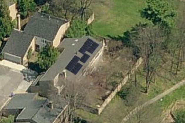
Solar Energy: The Case For Leasing Your Sustainable Energy Source. Here's an excerpt of an interesting article from
The Washington Times: "
Many
of us want to do the right thing for energy conservation and the
environment. However, it is difficult to make the correct decision,
especially when considering solar power. We recently had to make this
decision and believe that our decision-making process may help others.
We decided that a 20-year solar lease was the best option for us. We
leased an 8.56 kWh direct current (DC) system that provides about 5.86
kWh alternate current (AC). What this means is that the solar panels are
rated at a certain capacity, but when the DC they provide is converted
to what your home uses, AC, it loses about 15%."
Photo credit above:
"Solar energy viewed from the sky", photo from the story's author, Mario Salazar.


