June 17, 2010: NOAA reports "The
largest single-day tornado outbreak in Minnesota history occurred with
48 tornadoes across the state, and set the stage for a record breaking
tornado year that finished with 113 tornadoes statewide. There were
three EF-4 tornadoes and four EF-3 tornadoes in Minnesota on this day.
Four tornado fatalities occurred, which was the highest number since
July 5, 1978." It's more than a little ironic that another significant
tornado outbreak is possible later today, two years later to the day.
"
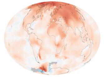
The last time global May temperatures were below the 20th
century average was in 1976. The last time any month was below average
was February 1985." - excerpt from the Summit County Citizens Voice; details below.
"
North America is witnessing the largest pine-beetle epidemic in
recorded history. From Canada's Yukon Territory to New Mexico, pine
trees by the hundreds of millions are succumbing to a fungus that the
beetles carry." - from a story in The Atlantic below.
"
According to researchers, most of North America and Europe will
see a sharp increase in the frequency of wildfires in the next 30
years. This trend is expected to continue until the end of the century." - from a story at Live Insurance News; details below.
Zombie Alert. Why worry about dew point and severe
thunderstorms when we'll soon be tracking the living dead on Doppler?
Details from CDC below.
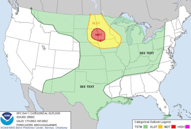
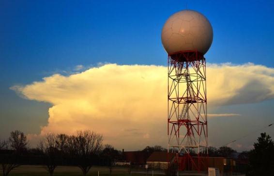
Father's Day Severe Threat: Significant Tornado Risk.
According to SPC a surge of hot, humidifed air may set off a few severe
storms from the Dakotas into western and central Minnesota (by
tonight). A few large, violent tornadoes are possible this evening in
South Dakota, pushing into southwestern and even central Minnesota early
tonight. Stay alert later today for watches and warnings. Details from
SPC:
FORECAST SOUNDINGS AT 00Z/MON IN ERN SD SHOW MLCAPE FROM 2500 TO
3000 J/KG WITH AN IMPRESSIVE SHEAR ENVIRONMENT. 0-6 KM SHEAR IS
FORECAST TO INCREASE DURING THE DAY REACHING 50 TO 55 KT BY EARLY
EVENING. THIS ALONG WITH A STRENGTHENING 40 TO 50 KT LOW-LEVEL JET
SHOULD BE FAVORABLE FOR TORNADIC SUPERCELLS. FORECAST SOUNDINGS NEAR
AND JUST EAST OF ABERDEEN AT 00Z/MON SHOW 0-3 KM STORM RELATIVE
HELICITIES OF 350 TO 400 M2/S2 WITH LCL HEIGHTS AROUND 700 METERS
SUGGESTING A THREAT FOR STRONG TORNADOES WILL BE POSSIBLE. IN
ADDITION...SUPERCELLS SHOULD CONTAIN LARGE HAIL WITH HAIL GREATER
THAN 2 INCHES IN DIAMETER POSSIBLE WITH THE MORE DOMINANT ROTATING
STORMS. AS STORM COVERAGE INCREASES DURING THE EVENT...A LINE OF
STORMS COULD ORGANIZE ACROSS SRN MN WITH DISCRETE ROTATING CELLS
EMBEDDED IN THE LINE. THE STRONG SHEAR AND WELL-DEVELOPED LOW-LEVEL
JET SHOULD HELP THE TORNADO THREAT TO CONTINUE INTO THE EVENING.
HOWEVER...A GRADUAL TRANSITION TO A WIND DAMAGE THREAT SHOULD TAKE
PLACE DURING THE EARLY TO MID EVENING. THE LINE COULD MOVE ESEWD
INTO CNTRL AND ERN IA BY LATE IN THE EVENING. THE SEVERE THREAT
SHOULD DROP OFF QUICKLY TO THE SOUTHWEST OF THE MCS MAINLY DUE TO
WARMING MID-LEVEL TEMPS.
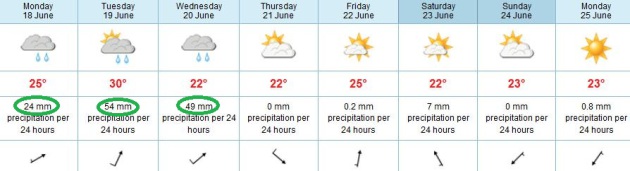
Seriously Soggy? Not sure I'm buying the ECMWF run
(yet), but with drippy, 70-degree dew point air surging north Monday and
Tuesday and a temporarily stalled frontal boundary nearby, there's a
potential for some excessive rainfall amounts. The European model
predicts an almost unbelievable 127 millimeters of rain by Wednesday
night. That's close to 5" of rain.
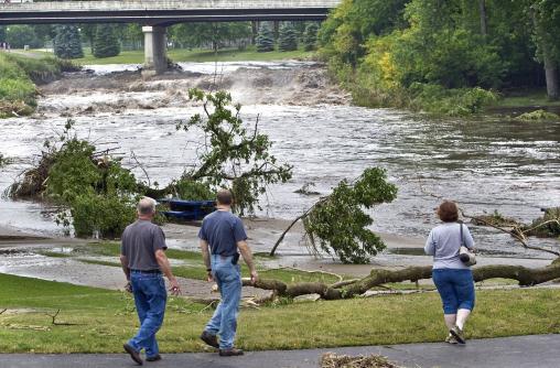
June 14 Record Rainfall Event. Mark Seeley has more on Thursday evening's record deluge south of the Twin Cities in his
WeatherTalk blog: "
But
the BIG STORY was the very heavy, record-setting rainfalls across
Steele, Rice, Le Sueur, Dakota, and Goodhue Counties. Observers in
these counties reported from 2 to 8 inches of rainfall during the
afternoon and evening. Some record-setting amounts included 2.22 inches
at Montgomery, 2.86 inches at Farmington, 6.37 inches at Red Wing Dam,
and 8.83 inches at Cannon Falls. The rainfall at Cannon Falls was a
new all-time statewide record for the month of June surpassing 8.67
inches at Minneota on June 17, 1957. As a result of the heavy
rainfalls the Cannon River and Little Cannon River rose several feet
and exceeded flood state, causing road closures and evacuation of some
homes."
Photo credit above: "
Residents of Cannon Falls, MInn.
survey the damage to Minnieska Park and a swollen Cannon River in Cannon
Falls, Minn. Friday morning June 15, 2012 following over night rains
that dumped over 8 inches of rain on the area causing many area rivers
to overflow their banks. (AP Photo/The Rochester Post-Bulletin, Jerry
Olson)."
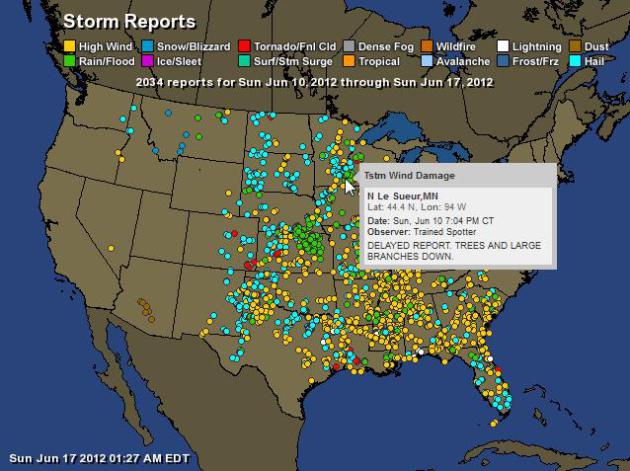
One Stormy Week. If you're keeping score (and who
among us isn't): 2,034 separate severe storm reports in the last week,
according to SPC. For an interactive map from Ham Weather
click here. Details:
| Total Storm Reports: |
2034 |
| Wind: |
1061 |
| Rain: |
257 |
| Snow/Blizzard: |
5 |
| Tornado: |
30 |
| Hail: |
653 |
| Lightning: |
14 |
| Dust: |
9 |
| 16: |
5 |
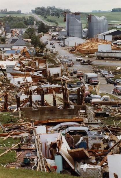
Remembering The Chandler Tornado. Bill McAuliffe at
The Star Tribune takes a look back at the last F-5 tornado to hit Minnesota, 20 years ago yesterday: "
Twenty
years ago Saturday, about 5:30 p.m., one of the strongest tornadoes in
state history blew apart the small southwestern Minnesota city of
Chandler, destroying 49 of its 131 homes, injuring more than 30 people
and wiping away nearly every familiar landmark. Damage in today's
dollars was $24.6 million. One woman died six weeks later; she'd been
injured when a wall fell on her. She waited out the storm in her
basement. It was the last F5 tornado to touch down in Minnesota."
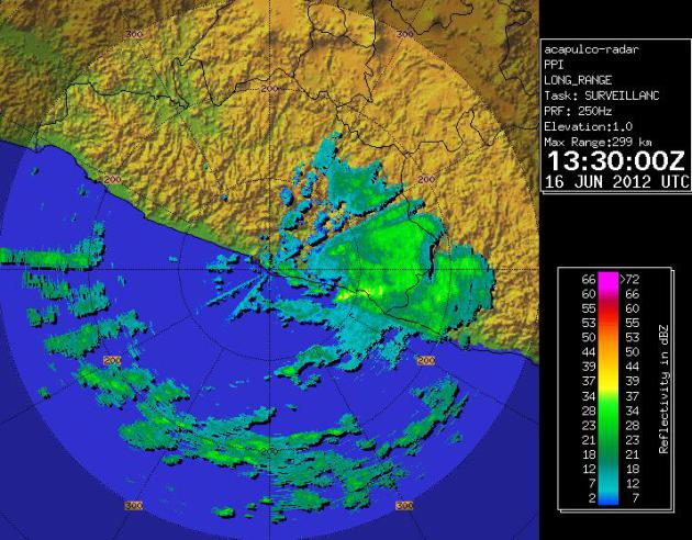
Acapulco Radar. The Saturday late morning radar
image above shows the soggy remains of Carlotta, which hit the Mexican
coast as a powerful Category 2 hurricane Friday night.
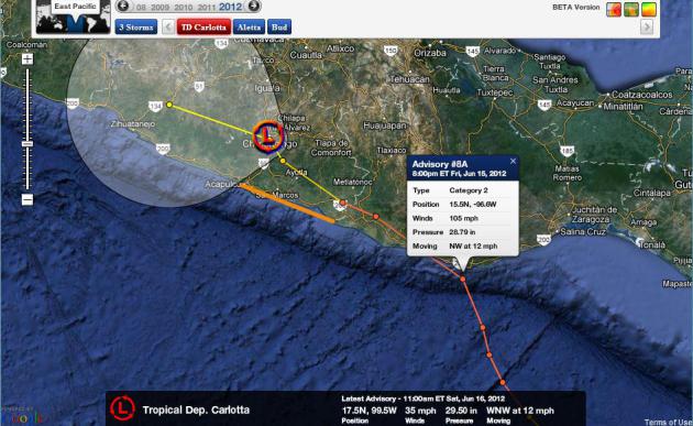
"Carlotta" Comes Ashore Near Mexico's Puerto Escondito. Details from
Reuters: "
Hurricane
Carlotta made landfall on Mexico's Pacific coast near the southern city
of Puerto Escondido late on Friday, unleashing heavy rain and gusts of
winds as far as the resort city of Acapulco, the U.S. National Hurricane
Center said. Carlotta, the third named storm of
the Pacific hurricane season, had escalated throughout the afternoon
into a Category 2 hurricane but weakened into Category 1 storm as it hit
coastal mountains in the state of Oaxaca. As it made landfall at
9 p.m. EDT, it had winds of nearly 90 mph (145 kph) with higher gusts.
It was about 10 miles (15 km) northwest of Puerto Escondido and about
190 miles (310 km) southeast of the tourist city of Acapulco." Map of Carlotta's track courtesy of NHC and Ham Weather.
Mexican Radar Sites. Heading to Mexico for a vacation or "business trip"? Here's a
handy web site, where you can tap into radar sites from Cabo San Lucas to Acapulco to Cancun. Definitely bookmark-worthy.
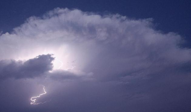
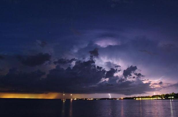
"Enlightening". Thanks to the Key West office of
The National Weather Service for sharing this shot, via Facebook: "
Cloud
to cloud and cloud to ground lightning strikes over the extreme
southeast portion of the Florida Peninsula. This picture was taken
earlier this evening from Key Largo by official storm spotter Joe
Sheriff. We are always interested in pictures of weather phenomena
around the Florida Keys."
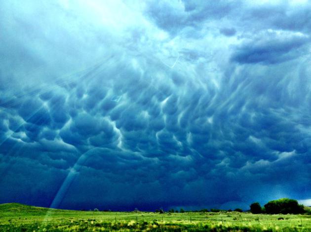
A Wild Sky. These must be mammatus, but they're
unlike anything I've ever seen. Thanks to Ivette Mendez-Kelley out in
Morrison, Colorado for sharing this photo.
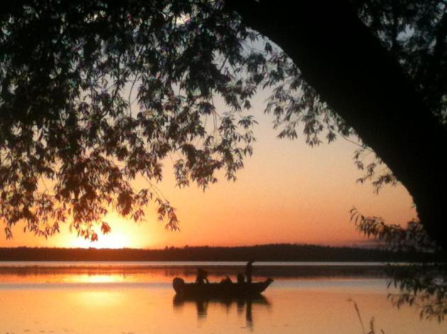
Weather Bliss. Friday was amazing up north, low
humidity, blue sky, a faint whisper of a breeze - June the way it was
meant to be on Pelican Lake in Orr. Photo courtesy of Payton Frostad,
who had the good sense not to be stranded on that fishing boat.
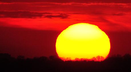
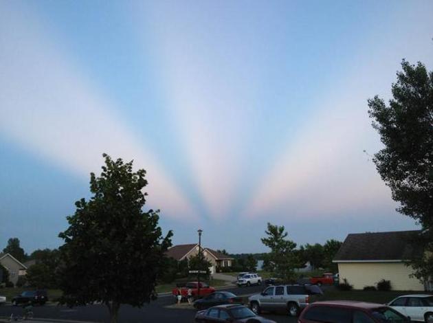
"Ask Paul". Weather-related Q&A:
Paul-
"I took this picture last Saturday in Buffalo,
MN. I was facing basically east, and I took the photo at around
sunset. I was wondering if there was some name for this phenomenon. I
hadn’t seen it before."
Thanks,
Steve Nisbet
Steve, you captured a great example of "crepuscular rays", or
twilight rays, only seen around sunrise and sunset, caused by scattered
of white light in dust and haze by objects (thunderheads?) over the
horizon. It can make for a breathtaking sight!
Best TV News Bloopers Of 2012 (Video).
TVnewscheck.com does the honors: "
Here's
our second wrap-up this year of some of those slips and gaffes that
almost immediately gain wide exposure through YouTube."
Preparedness 101: Zombie Apocalypse. Hey, the zombies are coming, so don't sweat the thundershowers tomorrow, ok? I'm a "Walking Dead" fan, and
this web site caught my eye. Clearly someone at Atlanta's CDC, the Center for Disease Control, has a well-developed sense of humor: "
If
zombies did start roaming the streets, CDC would conduct an
investigation much like any other disease outbreak. CDC would provide
technical assistance to cities, states, or international partners
dealing with a zombie infestation. This assistance might include
consultation, lab testing and analysis, patient management and care,
tracking of contacts, and infection control (including isolation and quarantine).
It’s likely that an investigation of this scenario would seek to
accomplish several goals: determine the cause of the illness, the source
of the infection/virus/toxin, learn how it is transmitted and how
readily it is spread, how to break the cycle of transmission and thus
prevent further cases, and how patients can best be treated. Not only
would scientists be working to identify the cause and cure of the zombie
outbreak, but CDC and other federal agencies would send medical teams
and first responders to help those in affected areas (I will be
volunteering the young nameless disease detectives for the field work)."
Tornado Threat Later Today
"A father carries pictures where his money used to be."
My father liked to remind me "once you have all
the information the decision is easy." Easier said than done. But every
morning I'd stagger down to the breakfast table, and there'd be a fresh
pile of newspaper and magazine clippings....weather stories.... waiting
for me. Now he sends me links to cool weather articles via e-mail. He's
still my best clipping service.
Give dad extra hugs today.
The older I get the less I take for granted. Like a remarkable pop...or a sunny Sunday.
Nothing says Thanks Dad better than SPF 50
sunscreen. Yesterday's clouds and showers are sweeping east. A
well-timed surge of drier air will keep us sunny today, highs in the low
80s as dew points drop back into the comfortable 50s. Today may restore
your faith in June.
The approach of hot, stuffy air sets off more
rounds of T-storms tonight, Monday and Tuesday (more tropical deluges,
even a few severe storms). The best chance of heavy rain: tonight and
early Monday, but a few severe storms are possible late Monday and
Tuesday as squall lines fire along a stalled frontal boundary.
SPC predicts a "moderate risk" of severe
storms today, which happens maybe 10-15 times a year - meaning a much h
igher threat of "supercell" thunderstorms capable of large, violent,
long-track tornadoes (especially southwestern Minnesota). There
will be watches and warnings later today, with the best chance of
violent storms south/west of the Minnesota River. By the time the squall
line reaches MSP (later tonight) it may be more of a straight-line wind
event.
The European, ECMWF, model brings some relief into Minnesota by late week, highs in the upper 70s from Thursday into Saturday.
The fishing's good up here on Pelican Lake,
where I saw savvy anglers checking radar on iPhones Saturday. I love it
when armchair meteorologists tell me when it's time to head for shore!
Climate Stories...
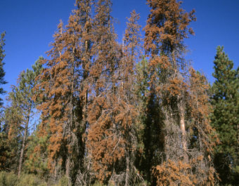
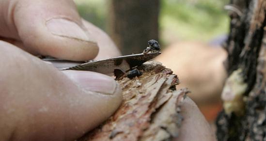
As Politicians Debate Climate Change Our Forests Wither.
Warmer winters sounds pretty good at first blush, until you realize
that pests, bugs and beetles, aren't getting killed off by the cold any
more. They can live yearround, with profound implications for our
forests, as reported by
The Atlantic;
here's an excerpt: "The pine-beetle epidemic provides perhaps the most
visual evidence of climate change in the United States. But that
evidence, while arresting, remains circumstantial. Scientific studies
linking the factors that drove the epidemic to rising global
temperatures haven't convinced everyone, let alone prompted people here
to forsake fossil fuels. It isn't just the dead trees. Here, near the
headwaters of the Colorado River, the snow is melting earlier--and
there's less of it. Summers are drier. Threats of wildfire and water
shortages have grown, changing lives and livelihoods in Colorado and
across the West.
Photo credit above: "A Mountain Pine Beetle is seen during the examination of trees in the White River National Forest near Vail, Colorado." (AP)
Glimmer Of Hope? Conservative Tackles Climate Change.
How do we leverage the free market and innovation to put a price on
carbon and encourage carbon-free energy alternatives. Can we grow our
economies without such a heavy reliance on greenhouse-gas pollution
fossil fuels? Here's an excerpt from
Skeptical Science:
"Climate
hawk David Roberts (Grist) accurately describes Adler’s piece as “an
eloquent, principled case for the simple notion that ‘embrace of limited
government principles need not entail the denial of environmental
claims.' Adler suggests four policy changes to “make it cheaper and
easier to adopt low-carbon technologies:” 1) prizes to spark
innovation, 2) lower legal barriers to deployment, 3) a
revenue-neutral carbon tax, and 4) adaptation."
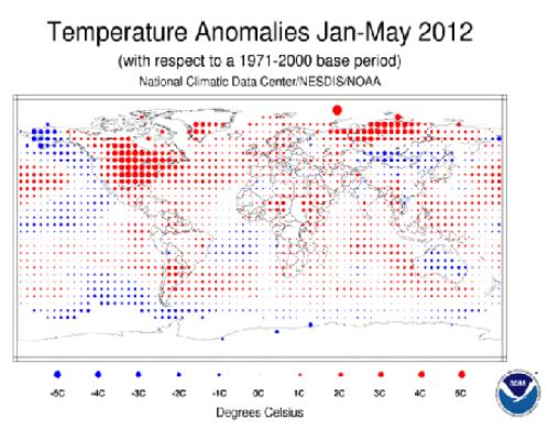
Global Warming: May 2012 Second Warmest On Record. Details from the
Summit County Citizens Voice: "
It’s getting hotter and hotter, the National Climatic Data Center announced
this week, releasing its monthly global temperature analysis showing
that the average land surface temperatures in May 2012 were the warmest
ever recorded. Land and sea surface temperatures combined averaged out
to the second-warmest May since record-keeping began in 1880. Only May
2010 was warmer. Measuring land surface readings only, the average
temperature was 2.18 degrees above the 20th century average. Land and
surface readings combined averaged to 1.19 degrees above the 20th
century average."
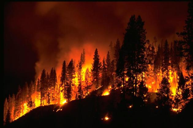
Climate Change Could Spark More Wildfires Around The World. An excerpt from
Live Insurance News: "
A new study
from the University of California and the Texas Tech University
suggests that climate change could have a profound impact on wildfire
patterns around the world. The study indicates that changing weather
patterns will create conditions that are more accommodating to fires.
These conditions would also make it more difficult for wildfires to be
contained. The reason behind this is largely linked to the fact that
large parts of the planet will have increased risk of fires. Controlling
the spread of fires over large expanses of land has long proven to be a
difficult feat."
Fighting Climate Change With Carbon Capture May Cause Quakes. Details from
Bloomberg Businessweek; here's an excerpt: "
Burying
carbon dioxide in the ground, considered a promising way to combat
climate change, may increase the risk of earthquakes, according to a
report. The process, in which liquefied carbon dioxide is stored in
caverns, “may have the potential for causing significant induced
seismicity,” the National Research Council said today. Injecting
wastewater underground from natural-gas fracking may also trigger
earthquakes, while using hydraulic fracturing to get trapped gas doesn’t
pose a “high risk,” the report found."
Climate Change Means More Work For Emergency Responders. The story from Asheville's
citizen-times.com: "...
With
warming temperatures, scientists expect more extreme weather events,
sudden downpours and extended droughts, which in turn could mean more
flooding or more wildfires, Haggard said. “Stay tuned to the Weather
Channel or the NCDC.” The burning of fossil fuel along
with the cutting of forests around the world has fueled a steady
increase in the Earth’s average temperature, Haggard explained.The
ocean has absorbed perhaps 50 percent of the carbon dioxide, making
the waters more acidic and threatening coral reefs and fisheries."
To Fix Climate Take Meat Off The Menu. Oh boy, this is a tough one - but in the spirit of full disclosure here is an excerpt of an Op-Ed from
The Washington Post: "
.....A 2006 U.N. Food and Agriculture Organization (FAO) report, “Livestock’s Long Shadow,”
called raising animals for food “one of the top two or three most
significant contributors to the most serious environmental problems, at
every scale from local to global.” Since then, climate researchers Robert Goodland and Jeff Anhang have estimated
that livestock and their methane-rich byproducts account for even more
greenhouse gas emissions than the earlier report estimated — a
whopping 51 percent. More conservative estimates say that meat accounts
for about a third of greenhouse gas emissions."