25"+ rain for the Florida Panhandle? Tropical Storm Debby is moving very slowly, prolonging heavy rain for the Emerald Coast of Florida. Some towns may pick up 6-8 month's worth of rain between now and Friday.
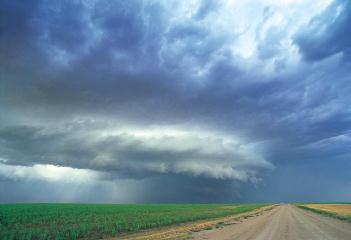
Tropical Storm Debby is nearly stationary in the northern Gulf of Mexico, packing 60 mph winds, whipping up tornadoes in it's spiral bands over Florida, soaking much of the Gulf Coast. The track is now expected to be over the Florida Panhandle, where some communities could wind up with 25" rainfall amounts by the end of the week due to the storm's very slow forward motion. But some models continue to take Debby west, toward New Orleans and Galveston.
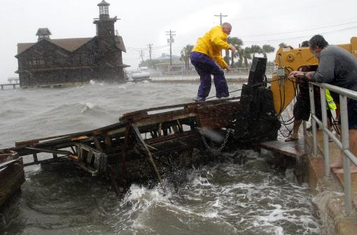
Photo credit above: "Cedar Key Fire Chief Robert Robinson walks on a section of a floating dock that broke loose during a storm surge from Tropical Storm Debby in Cedar Key, Fla., on Sunday, June 24, 2012. Slow-moving Tropical Storm Debby's outer bands lashed Florida with rain and kicked up rough surf off Alabama on Sunday, prompting storm warnings for those states." (AP Photo/The Gainesville Sun, Brad McClenny)

Louisiana Declares State Of Emergency Ahead Of Tropical Storm Debby. Officials aren't taking any chances, an update from Fox News here.
USA Records. One data point jumped out at me as I scanned this web link from NOAA NCDC. In the last 365 days the USA has experienced 4 times more record warm readings than record cold temperatures (69,718 vs. 15,555 respectively). But no, the atmosphere isn't warming up. It's all an illusion.
111 Duluth property owners had flood insurance when the storm hit, a fraction of the city's 25,485 homes, according to state records. - from a Star Tribune article about flood insurance below.

"Humans across the planet burn a million years' worth of “ancient plant goo” in the form of fossil fuels every year..."
“We're talking about the end of what we love and value,” yet too few people grasp it. The problems revolving around climate change won't be dealt with until people start waking up at 2 a.m. and realities are slapping them in the face.."

"The atmospheric conditions are changing to the point where “every weather event is different than it would have been,” Trenberth said. “We keep changing the climate so there is no new normal.” - all 3 excerpts from a story in The Aspen Times below.
Hour-By-Hour: A Chronology Of The Northland Floods Of 2012. Here's an excerpt of a terrific article, a blow-by-blow account of what will enter the record books as the biggest flood in Duluth history, courtesy of The Duluth News Tribune:
Tuesday, June 19
AFTERNOON
"Severe thunderstorms roll across much of the Northland, dropping hail and an initial round of heavy rain in many areas, including 2 inches in Floodwood. Flash flood watch continues. The News Tribune starts its severe weather live blog, which will continue on-and-off, as time allows, for the next 2½ days.
5-6 P.M.
Reports start to roll in from Grand Rapids and the western Iron Range of torrential rain and street flooding as another round of storms slowly sweeps across the area. Spotters report 1.5 inches of rain in 45 minutes in Grand Rapids, with streets under 4 to 6 inches downtown."
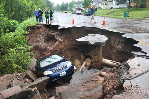
Photo credit above: "A car fell into a huge sinkhole on Skyline Parkway at 9th Avenue East in Duluth early Wednesday morning." Bob King, Duluth News Tribune.


Ask Paul. Weather-related Q&A:
Subject: Impact of impervious surfaces on Duluth flooding
"Hey Paul - I interned as a photographer for
the City of Duluth in the Summer of 1980. One of my first jobs was to
photograph and create a slideshow illustrating all the impervious
surfaces on the Duluth hillside (including the Miller Hill Mall) that
drained into the city proper. Even at the early time it was recognized
what a problem it was to cover so much of the upper part of the city
with concrete and asphalt, which even then was causing problems when
rainfall caused the city's creeks to overflow.
Fast forward to today - there is a ton more development up on the hill. Apparently some of the surfaces are are semi-pervious, and there are apparently some diversion or holding ponds, but it seems obvious to me that all the development at the top of the hill must have played an important part in exacerbating the flooding across the city.
Love your blog!"
Rob Levine
Thanks Rob - you bring up some very
good points about terrain and geology in the Duluth area - I wanted to
publish your e-mail, because there's little doubt that development
probably made a bad situation even worse. I'm no city engineer, but if
you pave large sections of a metro area, the water is going to be
channeled into storm sewers and city streets, and not have much of any
chance to soak into the ground, especially at the rate rain was falling
Tuesday night and Wednesday.
Flooding At Clearwater Beach. Not a great week to be vacationing in Florida. Thanks to meteorologist Jacob Wycoff for passing this photo and update along: "Flooding along the streets of Clearwater Beach,
where over 6" of rain has fallen today. Damaging flooding will probably
be the major story from #Debby."
Clearwater Beach "Basically Underwater" Due To Flooding. Clearwater Patch.com has an update.
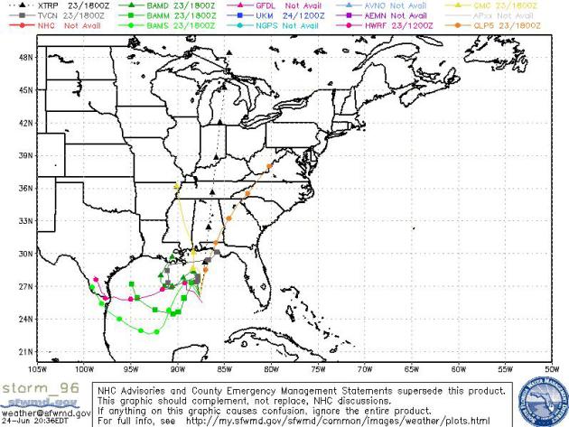
Debby's Track Still Up In The Air. The most likely scenario is a (very) slow north/northeast track into the Florida Panhandle, but the European (ECMWF) model continues to push Debby westward, toward Galveston, possibly brushing New Orleans with flooding rains. Map above: sfwmd.gov.
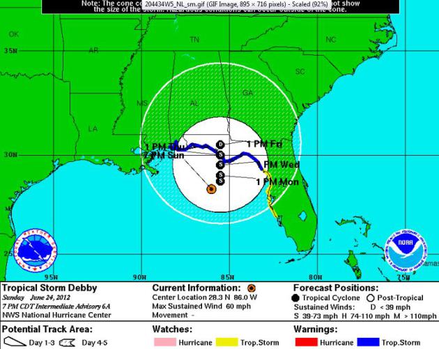
Slow Moving = Apocalyptic Rainfall Amounts For Florida Panhandle? Debby is forecast to move roughly 200 miles in the span of 5 days, sucking up moisture from the Gulf of Mexico and dumping it in the form of heavy rain squalls from Florida and south Georgia westward to the parishes of Louisiana. I have a hunch some coastal communities may wind up with 15-25" rainfall amounts by the end of the week, enough rain to produce catastrophic flooding. One city to watch closely: Pensacola, still recovering from 10-15" rain a couple weeks ago that created widespread flash floods. Map above courtesy of NHC.
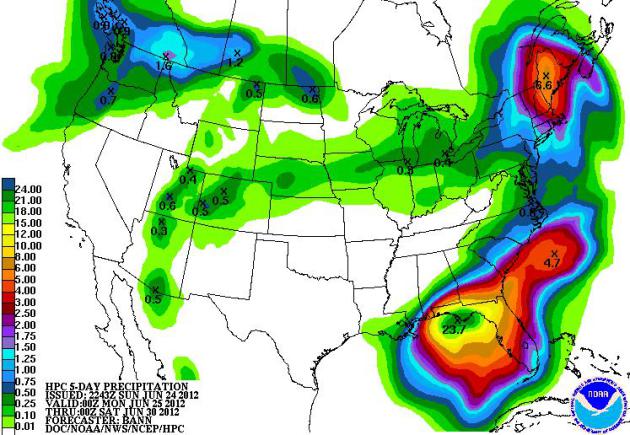
Extreme Flood Event For Florida Panhandle? Here's why I'm worried (I didn't just pull that 25" amount out of thin air). Debby is creeping north, which means heavy rain through at least Friday. I suspect a few towns between Pensacola Panama City and Tallahasse may pick up 20-30" of rain in the next 5 days. Map courtesy of NOAA.
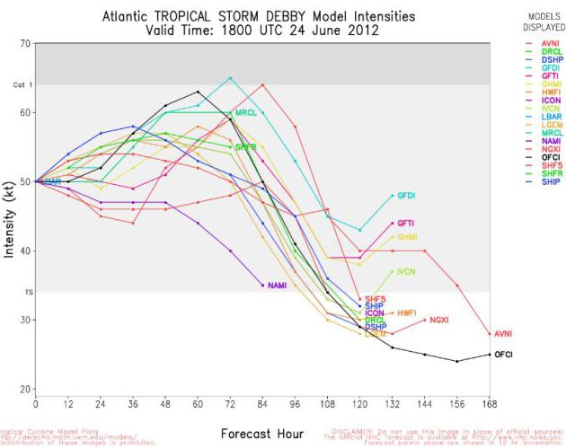
Most Likely Scenario: Debby Remains A Tropical Storm. Only 2 out of 18 high-resolution weather models strengthen Debby to marginal category 1 hurricane status. The tropical storm is close to shore, which will limit the "fetch" of moisture it can gather out over warm, open water. Keep in mind tropical storms produce some of the most extreme rainfall amounts, especially storms moving as slowly as Debby.
Uncertainty About Tropical Storm Debby's Path Causing Worries On Gulf Coast. With ultra-light steering winds aloft, the future track of "Debby" is one of the most difficult in recent memory, impacting millions of Floridians and Gulf Coast residents. National Geographic News has more details; here's an excerpt: "Hurricane forecasters are warning of tropical storm-force winds of at least 35 mph (56 kph) by late Monday from Louisiana to the Florida Panhandle, but caution that Tropical Storm Debby’s path is very uncertain as it churns through the Gulf of Mexico toward a likely landfall somewhere on the Gulf Coast later this week. That uncertainty is making it difficult for Gulf Coast residents to prepare for the storm. “This storm is the worst-case scenario for (the) emergency manager,” said William Wagner III, president of Early Alert Inc., a private company specializing in emergency management consulting and disaster preparation based in Palm City, Florida."
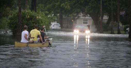
Photo credit above: "Canoe-goers navigate flooded streets as flooding continues to worsen and Tropical Storm Debby pounds the Tampa Bay, Fla., area Sunday, June 24, 2012. Tropical Storm Debby continued to churn in the Gulf of Mexico." (AP Photo/Tampa Bay Tribune, Chris Zuppa)
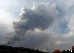
Colorado Springs Wildfire Grows To More Than 2,000 Acres. Here's an update from Huffington Post: "COLORADO SPRINGS, Colo. — Wildfires moved in on some of Colorado's most popular summer tourist destinations over the weekend, demolishing nearly two dozen homes near Rocky Mountain National Park and emptying hotels and campgrounds at the base of Pikes Peak. A wildfire near Colorado Springs erupted and grew out of control to more than 3 square miles early Sunday, prompting the evacuation of more than 11,000 residents and an unknown number of tourists. On Saturday, a blaze destroyed 21 structures near the mountain community of Estes Park, where many visitors stay while visiting the park."
Photo credit above: AP.
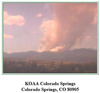
100 F. in Colorado Springs Sunday, tying the record. According to KOAA-TV it was only the 5th time in recorded history Colorado Springs has reached 100.
102 F. high at Denver yesterday.
100 F. high recorded at Dallas, first 100-degree high of the year.
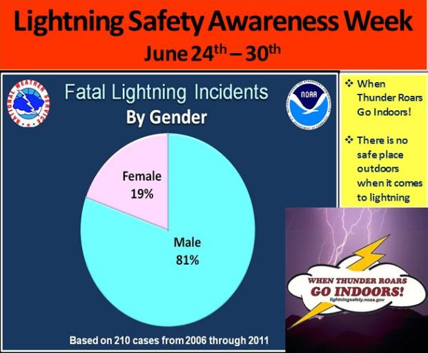
Particularly Unlucky - Or Stubborn? Here's a graphic from the Hanford, California office of The National Weather Service. Are men particularly unlucky, or just stubbornly stupid? "I'm going to get this last hole in even if it kills me!" Right. The truth: more men than women work outside, so this is probably a reflection of that. Or is it? Details via Facebook: "Lightning kills fours times as many men as women. Remember, when working or playing outdoors, seek shelter at once if the weather turns threatening."


Dreaded Dew Point
Leave it to a weatherguy to leave you feeling
worse than you thought possible. In the winter we torment you with wind
chill. Hey, the public has a right to know! Summer brings the heat
index, which factors air temperature and dew point to let you know what it will really feel like out there.
At the request of loyal newspaper readers I've started to include dew point (DP) predictions in the 7-Day, above.
Dew point is superior to relative humidity, which changes with
temperature. One number, and you can instantly tell how ghastly it's
going to feel.
A dew point in the 50s (today) is comfortable. But for every 20 degree rise in dew point the amount of water in the air doubles. By midweek dew points top 70. Another free sauna is imminent.
Enjoy today's sun and comfortable breeze, because the
ECMWF (European) model is hinting at 5 more days above 90 by next
Tuesday, July 3. Mid-90s are expected Wednesday of this week, in fact a
hot bias spills over into the 4th of July.
I'm worried about
the Florida panhandle; Pensacola still recovering from recent floods.
"Debby" may unleash another 5-20" rain by Thursday, temporarily stalling
near Pensacola. I fear yet another 1-in-100 year flood. We've had a
number of those lately, and no, it's not a cosmic coincidence.
"Living In The New Abnormal". For about 10-15 years now I've been talking about Weather 2.0, how weather patterns have shifted, evolved...mutated into something almost unrecognizable some days. Here's an excerpt of an Aspen Times article that caught my eye on Sunday: “....We're living in a new abnormal, perhaps,” said Dennis Dimick, National Geographic magazine's executive editor for the environment. He showed detailed graphic displays that demonstrate how global temperatures have increased 1.5 degrees Fahrenheit since the 1970s. Projections indicate that summers in 2040 to 2060 will be “warmer than the warmest on record,” he said. Go ahead and throw weather records out the window, agreed Kevin Trenberth, senior scientist with the National Center for Atmospheric Research. The atmospheric conditions are changing to the point where “every weather event is different than it would have been,” Trenberth said. “We keep changing the climate so there is no new normal.”
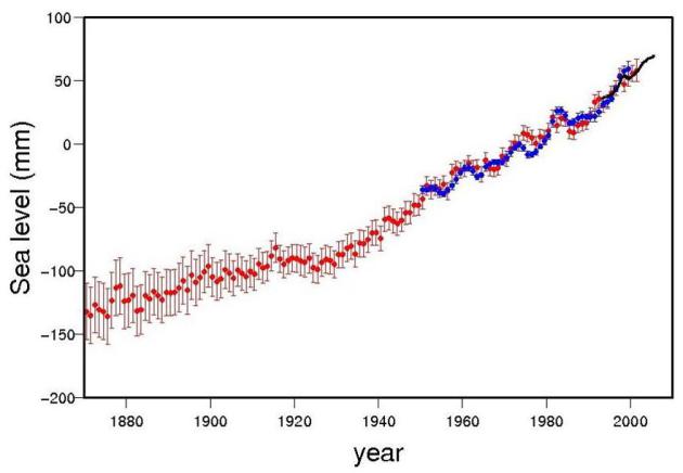
Sea Rise Faster On East Coast Than Rest Of Globe. The story from AP and U.S. News and World Report; here's an excerpt: "WASHINGTON (AP) — From Cape Hatteras, N.C., to just north of Boston, sea levels are rising much faster than they are around the globe, putting one of the world's most costly coasts in danger of flooding, government researchers report. U.S. Geological Survey scientists call the 600-mile swath a "hot spot" for climbing sea levels caused by global warming. Along the region, the Atlantic Ocean is rising at an annual rate three times to four times faster than the global average since 1990, according to the study published Sunday in the journal Nature Climate Change."

Evangelicals Stand Up For The EPA On Climate Change. Here's an excerpt from The Paramus Post: "On Monday, EEN’s President, the Rev. Mitch Hescox, will meet with Environmental Protection Agency (EPA) Administrator Lisa Jackson, play the TV spot for her, and hand-deliver more than 40,000 messages of support from pro-life Christians.“We’re happy to stand side by side with Administrator Jackson as the EPA leads our country in reducing carbon pollution,” Hescox says. The TV spots highlight the extreme weather that has been plaguing the United States and point out that the poor in lesser developed nations are and will continue to experience more frequent and intense heatwaves, droughts, floods and other harmful impacts due to climate change. “You do whatever it takes to protect someone you love,” the video narrator says. “What about the less fortunate in poorer countries? Climate change is threatening their lives. Jesus taught us to care for ‘the least of these,’ and today this means working to overcome climate change.”
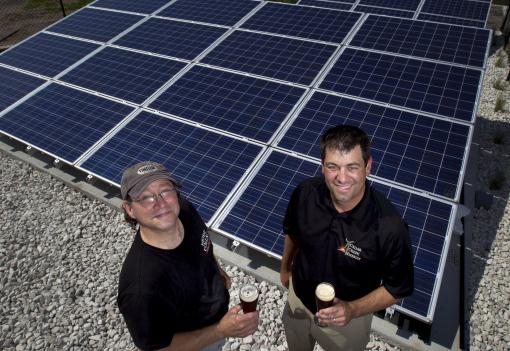
Solar Panel Installations Soaring. The story from The Journal Gazette; here's an excerpt: "Developers installed 85 percent more solar panels in the United States in the first quarter than a year earlier, led by strong growth in commercial projects and demand in New Jersey, according to the Solar Energy Industries Association. Total U.S. installations were 506 megawatts in the quarter and may reach 3,300 megawatts this year, about 11 percent of the 2012 global market, the Washington trade group said this month in its quarterly market report. That will make the U.S. the fourth-largest solar market this year, and one of the few countries where growth is expected to continue for the foreseeable future, according to GTM Research, a Boston consulting company that prepared the report with the Solar Energy Industries Association."
Photo credit above: "John Moore owner of Barley John's Brewpub and Rob Appelhof president of Cedar Creek Energy photographed in front of the solar array installed at Barley John's Brewpub in New Brighton, Minn. Cedar Creek Energy is working with Barley John's to offset some of their energy use with solar power." Carlos Gonzalez, Star Tribune.