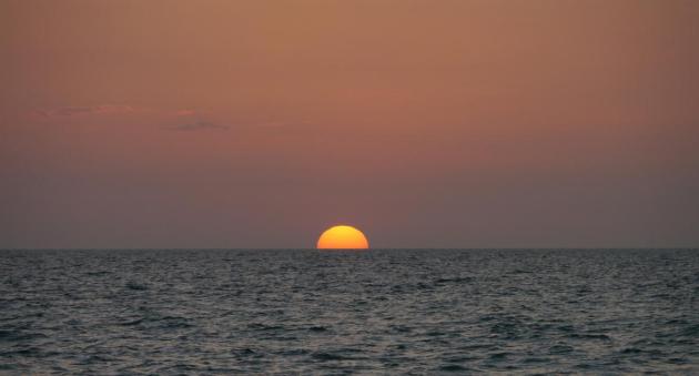
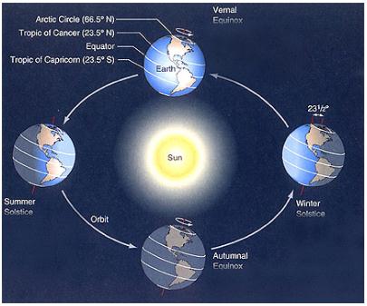
6:09 pm CDT: official arrival of summer, the Summer Solstice. The sun will be as high in the sky today as it ever gets.
15 hours, 37 minutes of daylight today in the Twin Cities.
8 hours, 46 minutes of daylight on December 21.
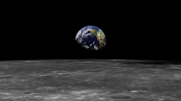
Welcome Summer Solstice! Today is the longest
(daylight) of the entire year; the sun's direct rays falling on the
Tropic of Cancer at 6:09 pm central daylight time. Graphic courtesy of
NASA.
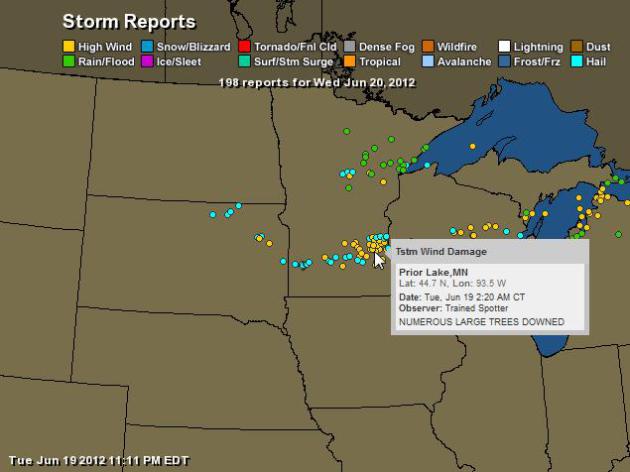
Flash Flood Watch. Here is the
latest from the local, Twin Cities, office of The National Weather Service:
FLOOD WATCH
NATIONAL WEATHER SERVICE TWIN CITIES/CHANHASSEN MN
733 PM CDT TUE JUN 19 2012

...HEAVY RAINFALL POSSIBLE TONIGHT AND WEDNESDAY...

.A FLASH FLOOD WATCH REMAINS IN EFFECT FOR MUCH OF CENTRAL AND
SOUTHERN MINNESOTA...ALONG WITH A SMALL PART OF WEST CENTRAL
WISCONSIN THROUGH WEDNESDAY. SOME LOCATIONS IN THE WATCH AREA
INCLUDE LITTLE FALLS...MORA...ST. CLOUD...WILLMAR...
HUTCHINSON...THE TWIN CITIES METROPOLITAN AREA...OWATONNA...RED
WING...RIVER FALLS...NEW RICHMOND AND BALSAM LAKE.

SEVERAL ROUNDS OF THUNDERSTORMS WILL OCCUR TONIGHT AND WEDNESDAY
AS A WARM FRONT LIFTS NORTH THROUGH CENTRAL MINNESOTA... FOLLOWED
BY A COLD FRONT LATER TONIGHT AND WEDNESDAY. TORRENTIAL RAINFALL
MAY OCCUR IN THE THUNDERSTORMS...WITH RAINFALL RATES OF 2 INCHES
PER HOUR LIKELY. THE GROUND IS NEARLY SATURATED ACROSS PORTIONS OF
CENTRAL MINNESOTA...FROM PREVIOUS RAINFALL OVER THE LAST COUPLE OF
WEEKS. REPEATED ROUNDS OF HEAVY RAIN WILL LEAD TO RAPID RUNOFF
ALONG WITH FLASH FLOODING. ADDITIONAL RAINFALL OF 1 TO 3
INCHES...WITH LOCAL AMOUNTS AROUND 4 INCHES...ARE POSSIBLE BY
LATE WEDNESDAY IN AREAS WHERE REPEATED ROUNDS OF THUNDERSTORMS
TRAIN.
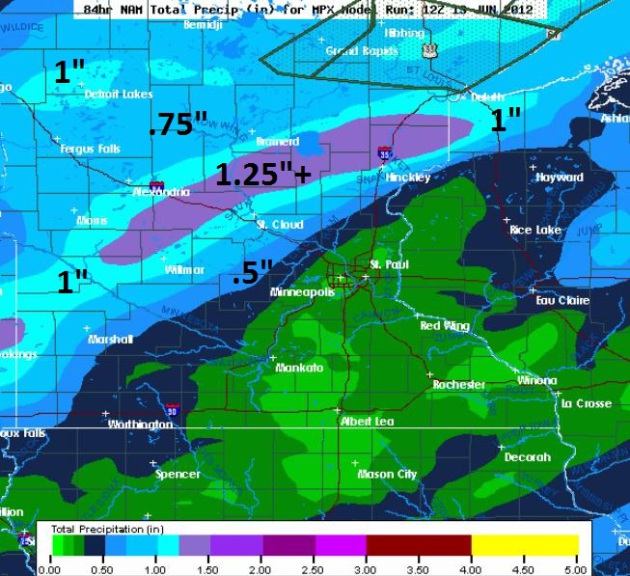
Predicted Rainfall. The latest 84-hour NAM model
prints out the heaviest rainfall amounts over central Minnesota, over 1"
forecast from near Benson and Alexandria to Lake Mille Lacs.
 Canadian Intrusions
.
Two cooler fronts are on the way to rescue us from the steamy, muggy
conditions we enjoyed/endured yesterday. Front #1 arrives today with
more showers and T-storms, some heavy. We cool off and dry out much of
Thursday and Friday before Front #2 sparks a few T-showers Friday night
into Saturday. A weak ridge of high pressure pushes into Minnesota
Sunday, winds swing around to the northeast, and we dry out once again
(in theory). GFS
model above courtesy of NOAA.
Storm Reports. It's easy to see the track of the
severe "supercell" thunderstorm that sparked winds as high as 83 mph at
Belle Plain early Tuesday. For an interactive map showing the last 24
hour's worth of storm damage
click here. Data from NOAA; map from Ham Weather.
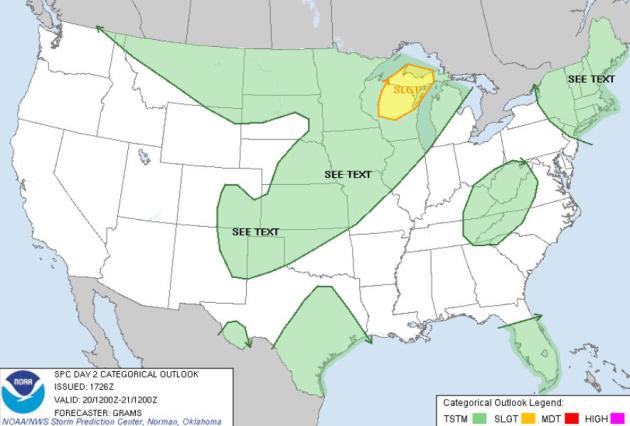 Today's Severe Storm Potential
. SPC has a small portion of central and northern Wisconsin and the U.P. of Michigan today, more hail and high winds possible.
Fewest May tornadoes, nationwide, in 60 years.
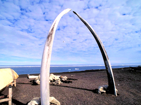
Perpetual Daylight. Summer officially beings at 6:09
CDT Wednesday. In Barrow, Alaska the last sunrise was on May 11, with
sunset on July 31, 82 days later. Thanks to Rich Thomas, chief
meteorologist at WSFA in Montgomery, Alabama for passing that nugget
along. Photo credit
here.
"As a matter of
conscience and common sense, we should be compelled to fight today's
insidious conspiracy of silence on climate change - a silence that
empowers misinformation and mythology to grow where science and truth
should prevail. It is a conspiracy that has not just stalled, but
demonized any constructive effort to put America in a position to lead
the world on this issue..." - excerpt of a Tuesday speech given by
Senator John Kerry at the Rio+2- United Nations Conference on
Sustainable Development; details below.
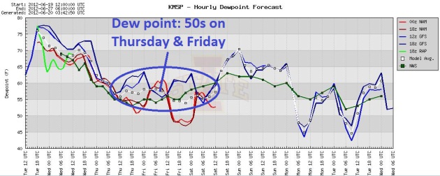
Muggy Today - Breathing Easier By Thursday. All the
models show a significant drop in dew point values (50s by Thursday and
Friday). A nearly 20 degree drop in dew point implies almost HALF as
much water in the air within 36 hours.
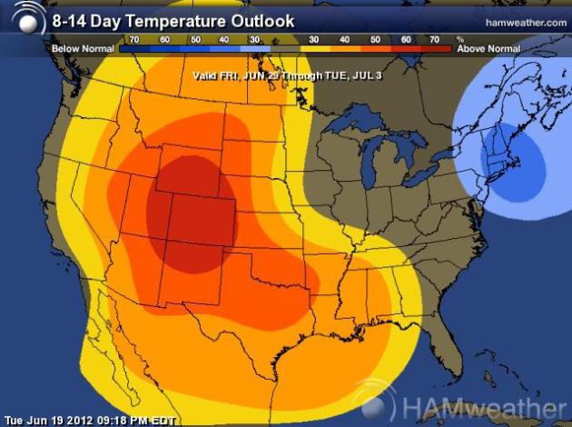
Hot Front. CPC's 8-14 Day Trend shows significantly
hotter than average weather for roughly the western half of the USA, a
slight warm bias for Minnesota and Iowa. Map courtesy of
Ham Weather.
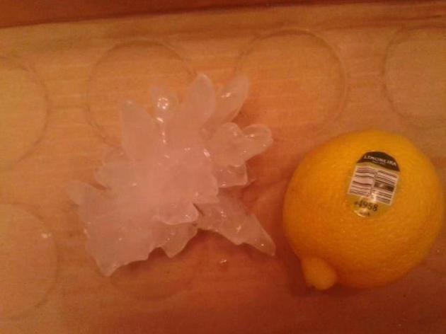
Lemon-Size Hail. I can't remember the last time I
saw hail that looked like this. Thanks to Megan and Kevin Komorouski
from Lonsdale, Minnesota - spiky hail fell during the wee hours of
Tuesday morning (1:30 am). It's getting to the point where we're all
going to need helmets just to go out and get the mail.
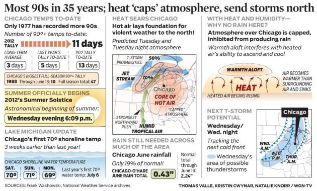
Most 90-Degree Days (11) For Chicago Since 1977. Tom
Skilling's crew at WGN-TV does a terrific job, on the air and online.
Here's a terrific infographic that explains why The Windy City has been
so hot this summer season. Graphic courtesy of
chicagoweathercenter.com.
Across The Country , May Was The Quietest Month For Tornadoes In 60 Years.
Tornado season peaking in March and April? Earlier tornado outbreaks
seem to be a trend, as climate change shortens our winters and
accelerates our springs. Here's an excerpt of an interesting story from
The Wichita Eagle at
kansas.com: "
Although
it’s been an active tornado season in Kansas, the rest of Tornado Alley
has been remarkably quiet. In fact, preliminary numbers indicate the
tornado tally nationwide in May was the lowest in 60 years. The
tentative national total for tornadoes in May is 110, well below the
10-year average of 300. For just the 15th time since records began
being kept in 1875, there were no deaths caused by tornadoes in May
anywhere in the U.S."
125 Years Ago Grand Forks Was Blown Away. North Dakota's
Dickinson Press has the details; here's an excerpt: "
A
hundred twenty-five years ago today, a tornado ripped through the heart
of Grand Forks and East Grand Forks. It killed eight, injured 100 and
caused an estimated $60,000 in property damage, or about $1.6 million in
today’s dollars. Yet it has been largely lost to the collective memory
of area residents. No plaques remember its victims. No history books
attested to its destructive power."
Mount Your Best Defense Against Tornadoes. Some helpful advice and good tornado information from
Fox Business; here's an excerpt: "
If
your home doesn't have a basement, get to the most interior, windowless
room on the first floor. The goal is to get low and put as many walls
between you and the outside. A closet or bathroom works best. Carbin
says steel piping helps to reinforce bathhroom walls, and there's also
been evidence that getting in a bathtub can be protective. If there's
time, put on a bike or sports helmet. Head trauma has been the main
cause of death in the most recent outbreaks or tornadoes, says Forbes.
Shield your body and head with blankets, pillows or even a mattress. Put
pets in carriers."
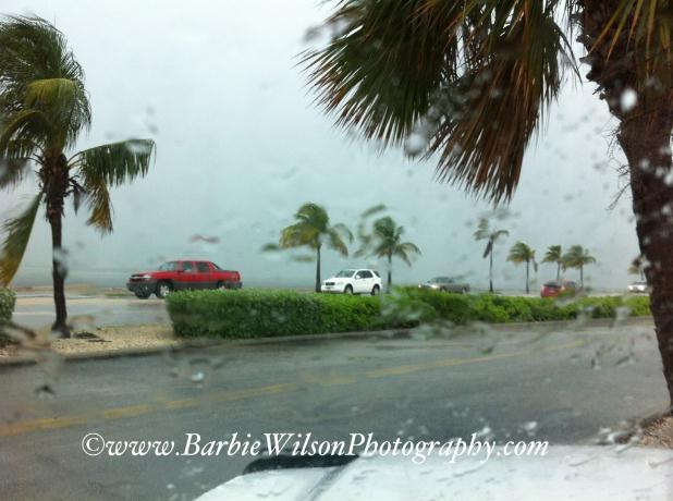
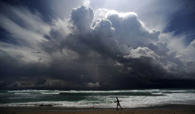
Florida Gully-Gushers. South Florida is getting
soaked (again) from a tropical disturbance centered over Cuba; some
areas from the Florida Keys north to Naples and Ft. Myers - east to
Miami and Boca Raton could wind up with 3-6" of additional rain in the
next 48 hours. Thanks to
Twitter and Barbie Wilson Photography for passing this pic along.
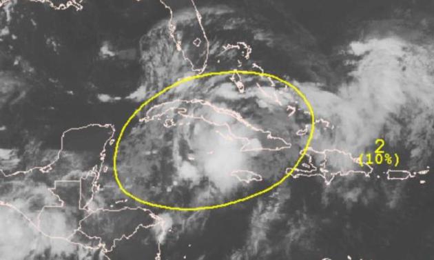
1 in 10 Chance of Tropical Storm Chris? NHC is
not impressed
with a tropical disturbance hovering over Cuba; they are predicting
only a 10% probability of this area of disturbed, thundery weather
growing into a tropical cyclone over the next 48 hours. More from the
Key West office of The National Weather Service: "
The
encircled trough of low pressure will be responsible for heavy
rainfall at times for the Florida Keys today through at least 800 am
Thursday morning. Upper level winds are not expected to be particularly
conducive for formation of a tropical cyclone over the next 48 hours.
Conditions may become more favorable for tropical cyclone development
when this trough of low pressure progresses westward into the Gulf of
Mexico later this week."
Read more here: http://www.kansas.com/2012/06/17/2377107/across-the-country-may-was-quietest.html#storylink=cpy
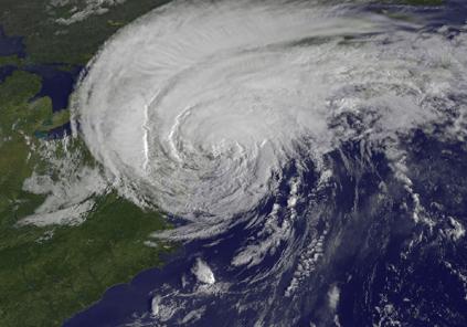
Storm Intensity Forecasts Lag; Communities More At Risk.
Hurricane forecasters do an admirable job predicting the track of
hurricanes, but forecasting intensity of a landfalling hurricane is much
more challenging. Here's an excerpt of a fascinating article from
meteorologist Andrew Freedman at
Climate Central: "
The
2011 North Atlantic hurricane season cost the U.S. billions in damage,
largely from inland flooding. Hurricane Irene alone killed 45 people
and cost upwards of $7.3 billion, according to the National Oceanic and
Atmospheric Administration (NOAA). But while Irene’s storm’s track was
forecast with near pinpoint accuracy days in advance, in keeping with
the general state of the science, the intensity forecasts were not
nearly as accurate. With the 2012 Atlantic hurricane season now
underway, forecasters are determined to make more accurate forecasts.
As part of a NOAA project known as the Hurricane Forecast Improvement
Program, or “HFIP,” they are armed with upgraded tools to help them
more accurately predict the path and intensity of these massive storms."
Photo credit above: NASA/NOAA GOES Project.
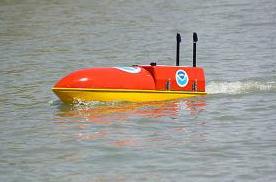
Weather Drones To Aid Research Into Forecasting Hurricanes.
Military technology is "trickling down" into the civilian sector, in
this case providing additional data that may help forecasters with
hurricane intensity. The story from The Orlando Sentinel and
The St. Augustine Record; here's a snippet: "
They
don’t look much like boats, or robots for that matter. Yet a small
fleet of crewless watercraft are to be sent right into the paths of
tropical storms for the first time this year with an important mission:
Collect valuable ocean and atmospheric data that should improve
hurricane forecasts. “We want to obtain swift and continuous data from
the eye of the storm for several days, which is very difficult to get
in real time,” said Justyna Nicinska, a program manager with the
National Oceanic and Atmospheric Administration."
Photo credit above: "
This small boat, called EMILY, will be directed into the path of hurricanes this season to collect storm data." (Courtesy: Hydronalix Inc. / June 14, 2012)
No Hurricanes In A Few Years, But Insurance Rates Remain Center Of Storm. The Naples Daily News web site at naplesnews.com has an
interesting story
about insurance premiums rising and companies dropping coverage for
some "high risk" customers, in spite of a lack of a direct, landfalling
hurricane in Florida in 7 years.
Hurricane Prep For Your Pets. You hope you never need this information, but just in case,
TCPalm.com has some helpful advice on how to prepare the most vulnerable members of your family for a hurricane; here's an excerpt: "
Some
of those preparations are easy to remember; make sure you have enough
of your pet’s medications on hand and stock up on food and water, for
example. But other preparations must also be considered, such as
keeping your latest inoculation and pet license information on hand and
having crates available for transportation. Most importantly, microchip
your cats and dogs now for easy identification, should you become
separated from them during a storm. It’s not enough to rely on tags
attached to collars, as these can easily come off in an emergency."
GPS Technology Improves Weather Forecasting.
ScienceDaily.com has a story about the benefits of incorporating GPS technology into weather prediction: "
The
satellite-based Global Positioning System (GPS) technology that guides
modern in-car navigation systems is now being used to improve weather
forecasts. Researchers at RMIT University's SPACE Research Centre and
the Bureau of Meteorology are using GPS and low earth orbit satellites
to provide an additional type of temperature profile observation for
use in weather forecasting computer models. The computer models draw on
about a hundred thousand million current weather observations,
including data from 30 to 40 complementary satellite instruments, to
generate the information used by meteorologists to prepare weather
forecasts."
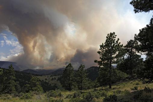
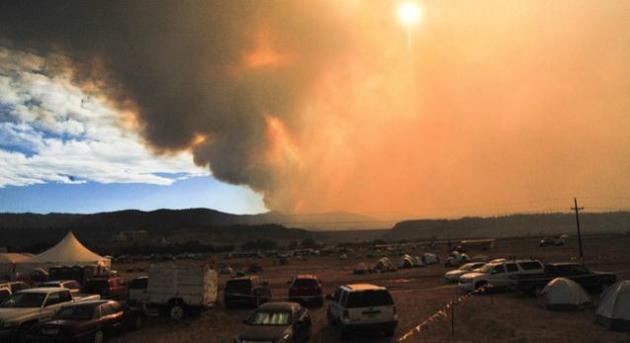
Colorado Scientists: Wildfires Make Their Own Weather. Here's another story that caught my eye from
The Denver Post: "
Researchers
striving to understand the ways wildfires make some of their own
weather are looking at clouds from both sides now. Colorado scientists
work to predict ground conditions by learning how heat and smoke
radiating from big fires like the more than 52,000-acre High Park fire
can affect wind and cloud formation. With more accurate forecasts,
fire managers could better predict fire behavior, deploy assets and
protect firefighters, residents and property, said Sher Schranz,
research coordinator with Colorado State University's Cooperative
Institute for Research in the Atmosphere."
Photo credit above: "
Smoke rises beyond a pasture as the
High Park wildfire continues to burn out of control near Livermore,
Colo., on Tuesday, June 19, 2012. The fire already has destroyed at
least 189 homes since it was sparked by lightning June 9. Incident
commander Bill Hahnenberg said it could be weeks or even months before
it's finally controlled." (AP Photo/Ed Andrieski)
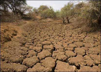
Recent Droughts Don't Compare To Those Of The Past.
The Dust Bowl of the mid-30s still sets the standard for extreme drought
across the USA. Since then land management has improved, lowering the
risk of massive dust storms somewhat. Here's an excerpt of a story from
The Athens Banner-Herald
The Water Environment Federation: "
Georgia
has gone bone-dry during a series of harsh droughts dating back to the
1980s -- but long periods of drought may just be normal for our part
of the world, according to a new study. Historical rainfall
measurements go back only a little more than a century. But scientists
can study tree rings, which show how much trees grow year by year,
and reconstruct how wet or dry it was during the tree's lifespan. When
Neil Pederson and 11 other scientists analyzed tree-ring data from
forests in the Apalachicola-Chattahoochee-Flint river basin dating back
to the mid-1600s, they found extended dry periods considerably longer
and often more intense than what we've seen lately, according to
their article in the journal Environmental Research Letters."
"Ask Paul". Weather-related Q&A.
Paul
"I
wish you could cover ALL of Minnesota instead of so much Twin Cities
area. We in SE Minnesota are pretty much stuck in a drought, and you
never talk about that. As I get the Star Tribune, it would be
nice. Just to let you know, not ALL of Minnesota is basking in green
grass and gardens!
Beyond that, keep up the good work and send your rains here!"
Mark Sibert
Mark
- I'd encourage you to scroll through older Star Tribune weather blogs,
going back weeks or even months. I think you'll find that I try to
include data, stories, photos and links for the entire state. I'm
sensitive to a perceived "Twin Cities bias". The reality:
85%
of the population lives in or near the Twin Cities, so (of course) we
tend to spend more time on weather for MSP. But that doesn't mean we
ignore weather across greater Minnesota. I get it: all weather is local.
If you live in St. Cloud or Rochester you may not care about what's
happening 50-100 miles away. It would be logistically impossible for me
to tailor the blog for every town in Minnesota - as it is I spend 4-6
hours/day fine-tuning the stories, photos, links and extras that go into
the daily blog. It's a never-ending beast, but I try to pick stories,
maps and URL's that might appear to the most readers on any given day.
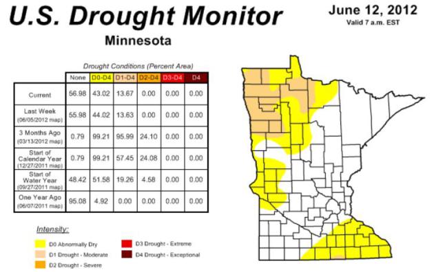
It's true, the metro is no longer in drought, so
that may shade my thinking about what's important and timely. Your
e-mail got me off the dime; I checked the latest
U.S. Drought Monitor
for an update on conditions statewide (latest information above). It
shows "abnormally dry" conditions for the southeast, but - technically -
no drought. Moderate drought conditions linger over the Red River
Valley. Thanks for your note - I promise I'll try to keep a statewide
perspective going forward.
_________________________________________________________________________
Hey Paul
"Weather is always fun, I was just outside
taking in a 5 minute break. I was noticing the clouds moving east to
west and lots of hot humid heat, I predict today will have some really
good storms , it always seems that when they move in a more reverse
action ( the clouds) we get more severe weather?"
Chris Schwanke
Chris - you're right. Although weather systems
usually move from west to east, an east/southeast wind flow in the
lowest few thousand feet of the atmosphere implies a storm to the west
or southwest of your location. Most T-storms are preceded by a
south/southeast surface wind and a rapidly falling barometer.
_________________________________________________________________________
Paul,
"You comment often about the global warming
and its effects on temperature and rainfall. But what about the wind? It
seems to me that there are many more windy days this year."
Mary McFetridge
New Hope
Mary - the greater the swings in temperature,
the faster winds have to blow to keep the atmosphere in equilibrium.
With climate change we're seeing a northward shift in temperature
gradients and subsequent wind speeds. Storms form along the boundaries
between cool air and warm air. As North America warms that temperature
gradient is shifting north. What further complicates matters is that the
Arctic is warming roughly twice as fast as the Lower 48 States of the
USA. We're in uncharted waters to some degree. I asked a few climate
scientists for their thoughts - one suggested a correlation between
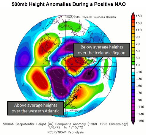
warming and (higher) wind speeds, another remarked that "shifts in storm tracks can be important but things like the NAO (
North American Oscillation) are huge." The truth: the jury is still out.
"Rock Stars" Of Kansas Weather: A Conversation With Four Local Broadcasters. The Wichita Eagle has the story at
kansas.com; here's a clip: "
Kansans
have a well-known obsession for weather, which makes celebrities of
the broadcasters who report it. There are few more recognizable people
locally. They are equally important to their stations – for ratings and
profits. In Wichita, that includes KWCH, Channel 12 chief
meteorologist Merril Teller, who has been there for almost 31 years;
KSN, Channel 3 chief meteorologist Dave Freeman, who has been there for
19 years; KAKE, Channel 10 managing meteorologist Jay Prater, who has
been there nine years; and KFDI 101.3-FM news director Dan Dillon, who
has been the voice of radio storm coverage for 33 years. It’s rare that
the four are together, but they have much to discuss when they are."
Read more here: http://www.kansas.com/2012/06/10/2366791/rock-stars-of-kansas-weather-a.html#storylink=cpy
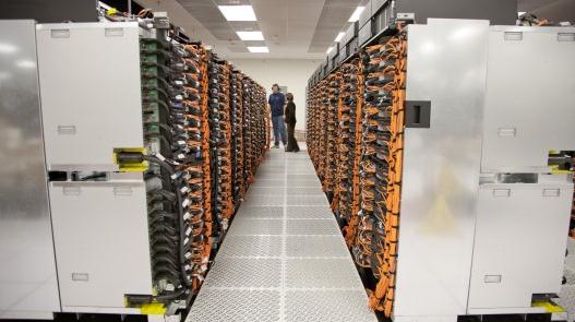
IBM's "Sequoia" Confirmed As World's Fastest Supercomputer. Here's an excerpt from a story at gizmag.com: "
Clocking
a performance of 16.32 petaflop/s, IBM's Blue Gene/Q-class
supercomputer Sequoia has become the fastest supercomputer in the world
according to the latest TOP500 rankings released today. Sequoia, owned
by the Department of Energy and based at the Lawrence Livermore
National Laboratory, has relegated Fujitsu's K to second place."
Tablet Adoption Explodes, Study Reveals Key Usage Patterns.
Here's a study that confirms what you may already suspect - the iPad is
dramatically changing how we use the Internet and consume media. An
excerpt from
lostremote.com: "
A
new tablet study by the Online Publishers Association reveals that
tablet adoption continues to skyrocket, now up to 31% of respondents —
and a surprising 74% use the device daily. The study (.pdf),
conducted with Magid, drills down on usage patterns and other handy
facts. It’s a great nuts-and-bolts study to have, and we’ve highlighted
TV-oriented data points below."
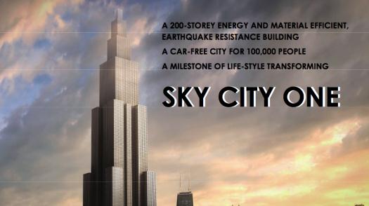
World's Tallest Building To Be Built In Only 90 Days. How is that even possible?
Gizmag.com has the story, here's an excerpt: "
Chinese
construction company Broad Group has announced ambitious plans to
construct the world's tallest skyscraper in an implausibly swift 90
days. If the target is met, the 838-meter (2,750-ft) "Sky City One" will
take only a twentieth of the time that the Burj Khalifa,
the world's current tallest building, took to construct, and will
stand 10 meters (33 feet) taller still upon completion. The secret to
the rapid construction is prefabrication. Approximately 95 percent of
the building will have been put together in modular form before work
even commences on site."
Microsoft Introduces A Challenger To The iPad. Details from The New York Times (subscription may be required): "
LOS ANGELES — In its most strategically significant push yet into the hardware business, Microsoft on Monday unveiled a tablet computer called Surface that is intended to challenge Apple’s iPad.
At a press event here, the company showed off a tablet that is
about the same weight and thickness as an iPad, with a 10.6-inch
screen. The device has a built-in “kickstand” that allows it to be
propped up for watching movies, and a thin detachable cover that will
serve double duty as a keyboard. "
* gizmag.com has more on the upcoming Microsoft Surface tablet
here.
**
gizmodo.com is impressed, in their words "Microsoft Surface just made the Macbook Air and iPad look obsolete."
New Device/App Could Turn Your Smartphone Into A Fish Finder. This nugget caught my eye, courtesy of those wondrous techno-geeks over at
gizmag.com: "
Your
smartphone and/or tablet can do just about everything else, why can’t
they help you catch fish? Well, if the Deeper fishfinder ends up being
commercially produced, they will be able to. The floating device would
be paired with the user’s Android or iOS device, and would let them
know if fish were in the area. To use Deeper, users would attach their
fishing line to one of three attachment points, depending on what sort
of fishing they were doing. Using their regular rod and reel, they
would then cast the 6-cm (2.4-inch) diameter sphere out onto the
surface of the water – fresh or salt – in which they planning to fish."
Size Matters. At least when it comes to TV screens.
Sharp is launching a 90" LED TV that will only set you back 11k. What a
bargain! Right. Christmas is coming. Then again, I'm not sure this baby
would fit under the tree.
Click here at your own peril.
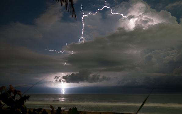
"Enlightening" Weather
Did you happen to catch the (wild) lightning
display with the last few squall lines? Unless you were in a coma you
were probably jolted out of bed too. The same severe storms that whipped
up 83 mph gusts at Belle Plain and spiky, lemon-size hail at Lonsdale
(check the blog) sparked a lightning display that looked like the
opening credits for the Book of Revelation.
There's a direct correlation between lightning
frequency and the severity of a storm. Continuous lightning? Head for
the basement. "We've found the threshold to be 25 strikes/minute" said
Earth Network founder Bob Marshall. His company has deployed a global
network of lightning sensors; in many cases severe lightning can tip off
forecasters 15-20 minutes before a severe storm warning is issued.
Impressive technology.
Rain and storms linger today as Canadian air
approaches; by Thursday dew points drop into the 50s, meaning nearly
half as much water floating overhead than yesterday.
Lately it seems like every other day we get whacked by severe storms - I'm happy to report a quiet spell Thursday & Friday.
T-storms Saturday give way to Sunday sun. I'm praying for a lake-friendly weekend.
By the way, summer officially arrives at 6:09 pm this evening. Welcome Summer Solstice!
Climate Stories...
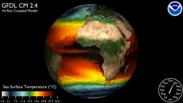
Yet Another Study Confirms Global Warming Is Human-Caused. Here's an excerpt from a story at
Ars Technica: "
Researchers
averaged the results from a number of climate models, and compared
that to global temperature records for the upper 700 meters of the
ocean from 1960 to 1999. The temperature record is less complete for
the deep ocean, and its massive volume and separation from the surface
subdues its response to climatic changes. In addition to the global
average, they also analyzed each of the major ocean basins (North and
South Atlantic, North and South Pacific, North and South Indian)
separately. They found that the anthropogenic “fingerprint” was
apparent in the observed temperature record at the 99 percent
confidence level. That means the observed warming is beyond
the variability seen in model simulations where greenhouse gases are
kept constant, but is exactly what the models predict for a world in
which humans change the composition of the atmosphere."
Is Climate Change To Blame For Massive Colorado Wildfire?
It's not possible to directly connect the dots between any one specific
storm, flood (or wildfire) and climate change. That preamble aside, a
warming (and in some cases drying) climate now pervades our weather
system, it flavors the day to day changes (and increasing extremes) we
track on our weather maps. Here's an excerpt of an interesting
(theoretical) story from
revmodo.com: "
For almost two weeks, the High Park wildfire in Northern Colorado
has captured American hearts, minds and headlines. In the first few
days, dry temperatures and beetle-killed trees allowed the fire to
spread across thousands of acres almost instantly. Firefighters from
Fort Collins, Colo., and beyond were brought in to help with the blaze,
assisted by members of the Colorado National Guard who lent two UH-60
Black Hawk helicopters for water drops over the area. Although it was
feared that extremely dry conditions and driving winds could feed the
fire into the autumn months, local authorities are now reporting at
least 50 percent containment. Now comes the truly ugly part, when
damage must be assessed."
Photo credit above:
thenationalguard/Flickr
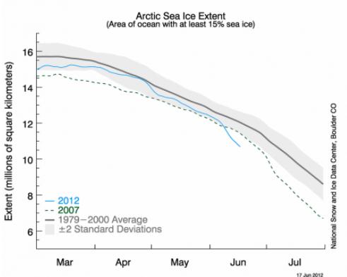
Global Warming: Arctic Sea Ice Extent Dips Toward New Lows. Here's an excerpt from a story at
The Summit County Citizens Voice: "
Arctic
sea ice extent, which hovered near average in May, has declined
rapidly in the past few weeks to dip well below average and below the
level it was this time of year in 2007, when it reached a record low in
September. “Basically, right now, we’re quite a ways below 2007, and
neck and neck with 2010, which was the lowest for this time of year …
we’re very near record low levels for this time of year,” said Dr. Walt
Meier, a sea ice expert with the Boulder-based National Snow and Ice Data Center."
Senator John Kerry Addresses Climate Change Inaction.
Yesterday, Senator John Kerry, Chairman of the Foreign Relations
Committee, delivered a major floor speech at the Rio+20 Conference
urging U.S. action to combat the threat of global climate change. Here
is an excerpt of his
speech: "
Thomas
Paine actually described today's situation very well. As America fought
for its independence, he said: "It is an affront to treat falsehood
with complaisance." Yet when it comes to the challenge of climate
change, the falsehood of today's naysayers is only matched by the
complacency of our political system. It is well past time that we heed
Thomas Paine's admonition and reaffirm the commitment made by the first
President Bush. As a matter of conscience and common sense, we should be
compelled to fight today's insidious conspiracy of silence on climate
change - a silence that empowers misinformation and mythology to grow
where science and truth should prevail. It is a conspiracy that has not
just stalled, but demonized any constructive effort to put America in a
position to lead the world on this issue, as President Bush promised we
would and as Americans have a right to expect we will."
Cities Lead Effort To Curb Climate Change As Nations Lag.
Bloomberg.com has the story; here's an excerpt: "
New York Mayor Michael Bloomberg
is leading an effort by 58 of the world’s largest cities to reduce
greenhouse-gas emissions while federal governments struggle to meet
global targets following two decades of discussions The member-cities of
the C40 Cities Climate Leadership Group produce about 14 percent of the
world’s greenhouse-gas emissions. Their actions to improve energy efficiency
and invest in renewable power will reduce emissions by 248 million
metric tons in 2020, Bloomberg said on a conference call. The cities can
cut emissions by more than 1 billion tons by 2030, or the equivalent
annual output from Mexico and Canada."
Photo credit above: "
Commercial and residential buildings stand in the financial district of Manhattan in this aerial photograph taken over New York." Photographer: Andrew Harrer/Bloomberg
Fear Of The Rising Seas. Here's an excerpt of a slide show at
The Washington Post: "
Residents
of Kilu village on the island of New Britain, Papua New Guinea, people
have had to move homes back from flooded beaches. As seas rise with
global warming, island states and low-lying costal communities
elsewhere report ever-higher tides encroaching on their shorelines.
Scientists project that seas will rise two feet or more in this century
if greenhouse gases pollute the atmosphere unabated.
" David Longstreath / AP
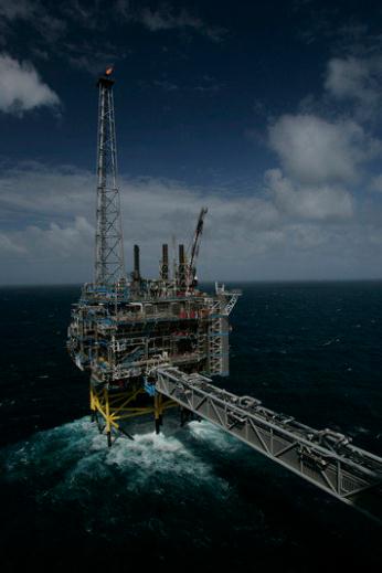
Underground Carbon Dioxide Storage Likely Would Cause Earthquakes. The
L.A. Times has the story; here's an excerpt: "
The
notion of mitigating harmful carbon dioxide emissions by storing the
gas underground is not practical because the process is likely to cause
earthquakes that would release the gas anyway, according to a
commentary published Monday in Proceedings of the National Academy of
Sciences. While the scientists do not expect that the approach would
cause any large and dangerous seismic activity, they say it is likely
that the earthquakes would be severe enough to jeopardize the ability to
store the gas underground over the long term."
Photo credit above: "
An 11-story unit in the North Sea
traps excess carbon dioxide, which is then pumped into the ground. This
method may cause earthquakes."
(Brian Vander Brug / Los Angeles Times / June 18, 2012)
Making The Impossible Possible: From Kennedy's Moonshot To Solar's SunShot. Here's an excerpt from an interesting (encouraging) story at
Huffington Post: "
In my two years as the director of the Energy Department's Solar Energy Technologies Program,
I have often been accused of being an eternal optimist. I see our
nation's energy challenges as an incredible opportunity -- one that has
the potential to revolutionize our economy, environment, and national
security. That's why, back in 2010, we established the SunShot Initiative
to decrease the total installed price of solar energy by 75 percent by
2020. We took our inspiration from President Kennedy's 1962 "moon
shot" speech that set the country on a path to regain the lead in the
space race and land a man on the moon. Many thought a manned lunar
mission was beyond NASA's capabilities, but this bold move ultimately
united the country when it proved successful."
Renewables No Fix For U.S. Military Fuel Woes. Here's a snippet of a story from
Reuters: "
Renewable
fuels for U.S. military ships and jets are likely to remain "far more
expensive" than petroleum products absent a technological breakthrough, a
study for the U.S. Air Force found on Tuesday, questioning a Pentagon
push for alternative energy. The study by the
RAND Corporation think tank said that while the U.S. Defense Department
is a huge consumer of fuel at about 340,000 barrels per day, that figure
is a tiny fraction of the 87 million barrels per day of global demand,
too small to influence price significantly."