Tropical Storm Debby: nearly
stationary in the Gulf of Mexico, packing 50 mph. winds - most models
bring Debby into Texas by Wednesday. The circulation is still
disorganized, no hint of an eye, at least not yet. Enhanced IR
loop courtesy of
intellicast.com. Details below.
Back To The 50s. If you love cars you'll want to
check out the MSRA "Back to the 50s" Show at the Minnesota State
Fairgrounds. Over 12,000 street rods, customs and classic cars will be
there. Details
here.
River's Edge Music Festival. Music lovers will be
loitering on Harriet Island this weekend. Dave Matthews plays tomorrow,
but there are scores of bands, one of the biggest concerts to ever hit
the Twin Cities music scene. Details
here. Just seeing a list of the bands playing today and tomorrow is enough to make you smile:
Today, June 24: Dave Matthews Band
The Flaming Lips · Puscifer · Polica · AWOLNATION · Diplo ·
MuteMath · Delta Spirit · K.Flay · AM & Shawn Lee · Mexican
Institute of Sound · Civil Twilight · Hey Rosetta! · Kids These Days ·
Yuna
 A Fine Summer Day
. Expect a brisk north/northeast breeze (10-20 mph), sunshine most of the day with highs in the low to mid 80s.
 Midweek Heat
.
Enjoy our relatively comfortable weather today and Monday, because we
heat up above 90 by Wednesday - I wouldn't be surprised to see mid-90s
Wednesday and Thursday, with some slight relief by Saturday; more 90s
next Sunday and Monday. I'm feeling better about my forecast of 20+ days
above 90 this year. Graphic above shows ECMWF
(European) data in Celsius.
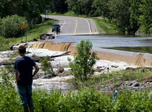
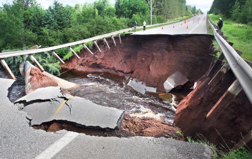
$50 million in damage to Duluth's infrastructure, according to Mayor Ness. Total damage toll may far exceed $100 million.
10% of Duluth's roads and utility infrastructure damaged by Wednesday's historic flooding. 100+ roads still closed.
Photo credit above: "
Lake Superior was filled with mud from flood runoff looking east from Duluth toward Wisconsin, Thursday, June 21, 2012." (Glen Stubbe/Minneapolis Star Tribune/MCT)
 Cost Of Minnesota Flood Estimated At $100 Million
. Details from
The New York Times: "
The waters in Duluth are receding, but the damage is done: the
northeastern Minnesota city estimates more than $100 million will be
required to repair utilities, streets, parks and trails in the city and
surrounding county of St. Louis, said Pakou Ly, a spokeswoman for
Duluth. The State Department of Transportation estimates its roads have
sustained $20 million worth of damage."
Photo credit above: "
Highway 23 was still a waterfall Friday, June 22, 2012 in the Fond du Lac neighborhood of Duluth." Photo courtesy of Glen Stubbe, Star Tribune.
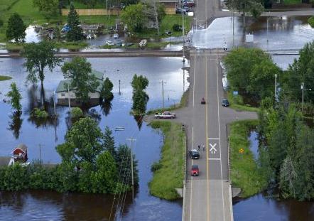
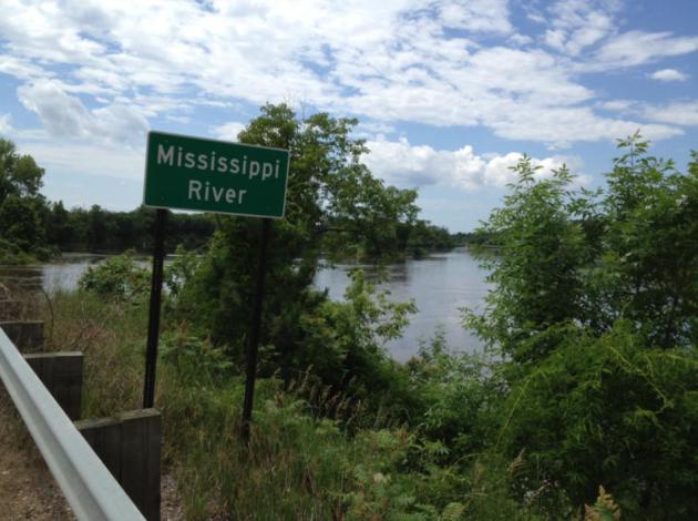 The Extra-Wide Mississippi
. I
snapped this photo Saturday morning, on Highway 4 just northeast of Brainerd. It's hard to tell from this perspective, but water levels were higher than anything I've ever witnessed.
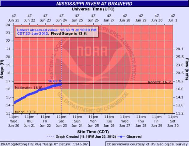 Close To A Record
.
As of 7 pm Saturday the Mississippi at Brainerd was less than 1/2"
below the all-time record level of 16.7 feet, set on April 30, 2001.
Graphic:
NOAA.
8.83" rain soaked Cannon Falls on June 14, a new state rainfall record.
15.11"
rain so far this month at Cannon Falls, "only the 4th time in
Minnesota's climate history that an observer has reported 15 or more
inches for June." Source:
WeatherTalk blog.
7.41" rain fell on Island Lake (St. Louis County) on
June 20, the second state rainfall record so far in June. Source: Dr.
Mark Seeley.
Photo credit above: "
Residents of Cannon Falls, Minn.
survey the damage to Minnieska Park and a swollen Cannon River in
Cannon, Minn. Friday morning June 15, 2012 following over night rains
that dumped over 8 inches of rain on the area causing many area rivers
to overflow their banks." (AP Photo/The Rochester Post-Bulletin, Jerry Olson)
450 cooling centers opened up in the New York City
area to deal with the impact of extreme heat. Details below from Climate
Central.
102 F. high in Denver, Colorado Friday, a record high for June 22.
Photo credit above: "
Youths cool down with an opened fire
hydrant in New York, June 21, 2012. Record-high temperatures marked the
second day of summer in the city." (Angel Franco/The New York Times)
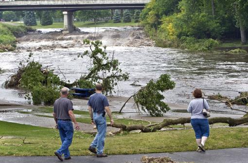
Minnesota Flood: "We Feel Overwhelmed". It will take many months for any semblance of normalcy to return to the North Woods of Minnesota.
The Morris Daily Herald has more details: "
As
residents here filled dumpsters with ruined possessions Thursday and
state officials surveyed gaping sinkholes and an estimated $100
million in damage from historic flooding, water suddenly rose farther
south, forcing more evacuations. In Moose Lake, about 40 miles south of
Duluth, city officials declared a state of emergency as water
encroached and surrounded the town. Well into the evening, residents
desperately sandbagged trying to hold back rising water. Some won. Some
didn’t."
Photo credit above: "
The small town of Brookston,
northwest of Cloquet, Minnesota was feeling the heat of the rising St.
Louis River Thursday morning, June 21, 2012." (Photo by Brian Peterson/Minneapolis Star Tribune/MCT)
Worst Ever Duluth, Minnesota Flood Causes $80 Million In Damage. More head-shaking details from
Reuters; here's an excerpt: "
Duluth
officials on Thursday estimated damage at up to $80 million just to
the city's public infrastructure from the flood that swamped the
northeast Minnesota city and nearby communities this week. The
flooding, which left huge sinkholes and ripped up dozens of roads,
also forced hundreds of people from their homes and killed several zoo
animals. Mayor Don Ness said the flood
was the worst in the history of the Lake Superior port city, surpassing
a 1972 flood both in damage and rainfall, and he estimated the damage
to public infrastructure at $50 to $80 million dollars."
Flash Flooding Wreaks Havoc In Duluth, Minnesota. More details from
Climate Central: "
After
18 hours of rain, the most rain the city of Duluth, Minn., has seen
at once in nearly 150 years, flash floods wreaked havoc on the city on
Wednesday. The floods followed 10 inches of rain and were more severe
than any floods that have occurred there in the past 100 years, according to the Minneapolis Star Tribune.
Creeks became raging rivers and the rushing waters ripped apart city
streets and created sinkholes. Two hundred and fifty people were
evacuated from the Fond du Lac neighborhood, which is the lowest of the
neighborhoods in Duluth. The mayor of Duluth, Don Ness, told the Associated Press
that “Fortunately . . . it’s a relatively small number of households
that are being evacuated . . . most homes in Duluth are farther up the
hill.”
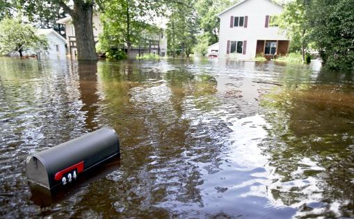
Photo credit above: "
A submerged mail box is the only sign
of the driveway for this flooded home on Lakeshore Drive in Moose
Lake, Minn., Thursday, June 21, 2012. The waters of the Moose Horn
river overflowed in to parts of Moose Lake after record rainfall hit
the area." (AP Photo/The Duluth News-Tribune, Clint Austin)
Duluth Flood: A Historical Perspective. Dr. Mark
Seeley takes a look at previous floods across northern Minnesota, trying
to put 10"+ amounts into some sort of long-term historical
perspective. Here's an excerpt of his latest post at
WeatherTalk: "
The
climate record from Duluth shows very few stormy periods that are
analogous to what happened there this week. Arguments can be made that
thunderstorms on September 5-6, 1876 (6.48 inches); July 20-22, 1909
(7.83 inches), and August 15-21 (7.91 inches) might be comparable, but
of course the Duluth neighborhoods and landscape in general were
vastly different in those times. It is expected that damage to
infrastructure in Duluth will be considerable this time around,
perhaps approaching or exceeding $100 million, compounded by a
prolonged recovery and reconstruction period."
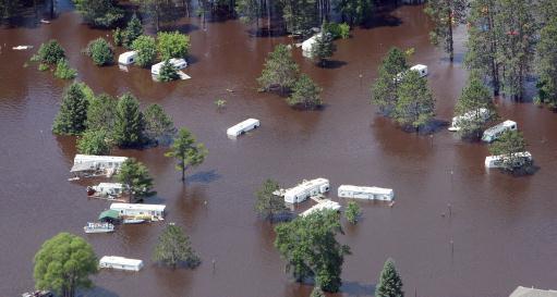
Photo credit above: "
RVs in the Moose Lake, Minn., city
park and RV campground are stranded in water overflow from the nearby
Moosehead Lake on Thursday, June 21, 2012. Damage assessment teams
from the Federal Emergency Management Agency are expected to be in the
area next week to start tallying the damage to public infrastructure in
14 counties and one Indian reservation." (AP Photo/The Duluth News-Tribune, Bob King)
Was Climate Change A Factor? The question keeps
coming up - people want to know if a warmer atmosphere somehow
contributed to the mega-flood that may ultimately cost Minnesota well
over $100 million. My answer, after teeing this up with climate
scientists I trust, is yes. People who say "you can't link any one event
with climate change" are missing the point. Climate and weather are
now hopelessly intertwined, linked - flip sides of the same coin. It's
basic physics: a warmer atmosphere holds more water vapor. If there's
more water floating overhead you increase the potential for these
extreme rainfall events. You may argue over how much is "natural" vs.
man-made, but there's no debating the fact that Minnesota is a warmer
place than it was 30-40 years ago.
A warmer atmosphere is now flavoring all weather events,
making winter snows more sporadic, reducing the number of subzero lows,
keeping ice on area lakes for fewer days, and increasing summer dew
points and humidity levels, doubling the number of 3"+ downpours since
1961, according to a new study that came out in May. This warmer
"background hum" is our new reality. It will continue to manifest
itself in strange, and (at times) violent ways in the years to come.
The truth: the rain isn't falling as gently as it did for our
grandparents. This trend will ultimately impact everything from how we
build our roads and homes to agriculture; engineering new strains of
crops that are more resistant to downpours and (increasing) bouts of
drought. The weather models we use are having a tough time keeping up
with this brave new Weather 2.0 environment - the maps are crazy: just
two months ago most of Minnesota was in an extreme drought - now we're
faced with one of the wettest Junes in Minnesota state history. Just
when you think you've seen it all...
Photo credit above: "
The Lester River flows through a gash
it created in Jean Duluth Road north of Duluth, Minn., Thursday
morning, June 21, 2012. City, county and state officials spent Thursday
assessing damage, while areas farther south continued to fight rising
floodwaters. The town of Moose Lake was being described as "an island." (AP Photo/The News-Tribune, Bob King)

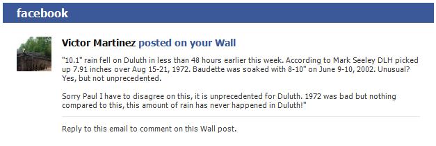
Victor - I see your point. There's no question Duluth just saw a
historically significant rainfall. I referred to it as a 1-in-100 year
flood. I'm not sure we have enough data to say it's "unprecedented", but
I agree that 10" rain for the North Woods is incredibly unusual,
off-the-scale weird. As I wrote (above) climate change was a undoubtedly
a factor in turbocharging rainfall amounts, so this may very well have
been the most rain to ever fall on the Duluth area from one storm.
Accurate data goes back to the mid-1800s, before that we really don't
have a clue about specific extreme rainfall events. The more I look at
the storm aftermath -
the more I'm willing to adjust my point of view and admit that, yes, last week's flooding probably was unprecedented.
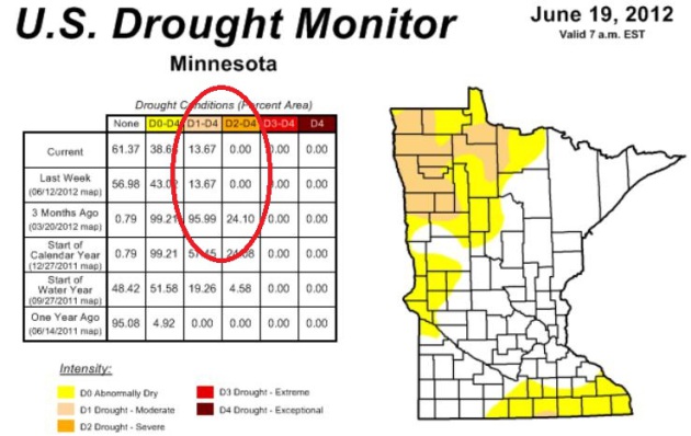
What Drought? It's amazing how far we've come since
late March, when 96% of Minnesota was in a moderate drought, 24% of the
state in severe drought. Now only a small portion of the Red River
Valley is in a moderate drought. The latest U.S. Drought Monitor is
here.
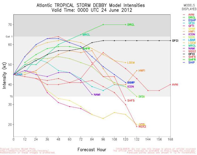
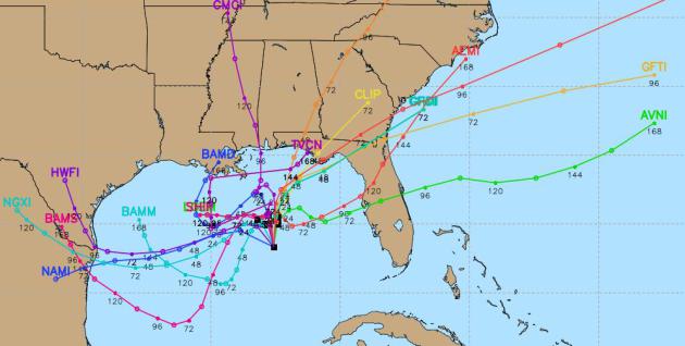
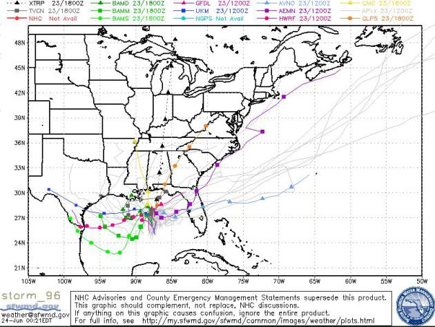
Why Weathermen Drink. This "spaghetti plot" shows
various model predictions, showing the future track of Debby. Pretty
obvious, huh? Good grief. Some models bring Debby into the Florida
Panhandle by tonight, but the majority suggest a westward track, toward
Texas by midweek. Steering winds over the Gulf of Mexico are very light,
which favors continued strengthening, but makes predicting the ultimate
track more problematic than usual. All residents living along the Gulf
Coast should stay alert.
Place Your Bets. Here's a wider perspective, showing multiple model predictions. Map courtesy of
sfwmd.gov.
 Debby: Destined To Remain A Tropical Storm?
Only one model strengthens Debby to hurricane force before landfall -
odds favor Debby will come ashore as a tropical storm. Source
here.
84-Hour NAM Outlook. NOAA's latest model run shows a
(weakened) "Debby" hitting coastal Texas as a weak tropical storm after
soaking much of Florida with flooding rains; unusually cool weather
grips the Northeast and the Pacific Northwest - more 90-degree heat building over the nation's midsection into midweek.
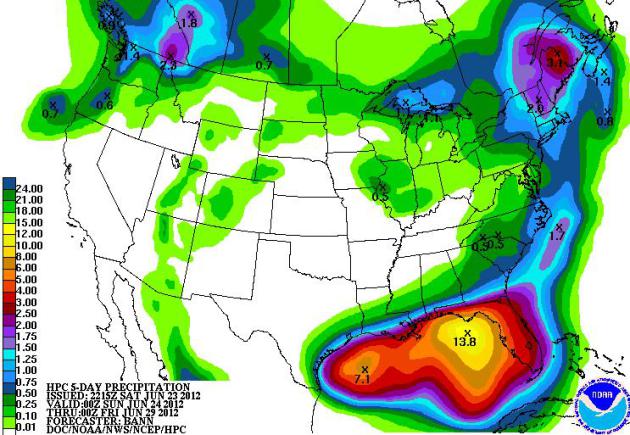
Florida Soaking. The tropical disturbance
strengthening in the Gulf of Mexico is forecast to dump 3-10" of rain on
Florida through the weekend, the best chance of 10" over Florida's
Emerald Coast (panhandle. Map: NOAA HPC.
Summer Comes In With A Bang Setting Heat Records.
Here is a partial list of record-setting heat records in the Northeast,
along with some resources to try to put this into perspective, courtesy
of
Climate Central: "...
Climate
studies show that, likely in part because of global warming, there
are now many more record highs being set in the U.S. each year
compared to record lows. In 2011, the ratio was about three warm
temperature records to every cold temperature record. To track record
temperatures in your region, take a look at our Record Temperature Tracker. You can also see how much your state has warmed over the past 100 years by looking at our “Heat Is On” Interactive map."
Photo credit above: Climate Central and flickr/
afagen
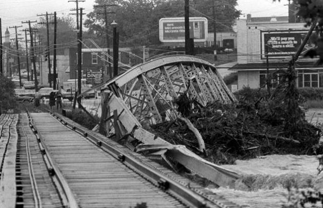
40 Years Lager, Agnes' Wrath Touches Off Flood Of Memories.
It was only a tropical storm, but "Agnes" stalled over Pennsylvania,
doing a big loop over the state, prolonging tropical rains. The storm
flooded out our basement ( still have vivid memories of swimming in 5
feet of cold, muddy water, in my underwear [TMI] sorry) - and ultimately
"Agnes" got me interested in a career meteorology. Here is a recap of
the storm that triggered Pennsylvania's worst floods on record from
Lancaster Online: "
Forty
years ago the "A" storm of the hurricane season arrived here on June
22. It was a relatively weak one when it first made landfall in
Florida. But as Hurricane Agnes started to make its way up the east
coast and converged with another low pressure system over Pennsylvania,
it reached its full intensity and became the costliest natural
disaster in the United States at that time. The damage and death toll
was the highest in Pennsylvania, with about 50 deaths and $2.3 billion
in losses. "We haven't had an event that can match Agnes," Eric Horst,
director of the Weather Information Center at Millersville University,
said."
Photo credit above:
"Agnes floodwaters collapsed the Engleside Bridge, south of the city, into the raging Conestoga River." (Lancaster Newspapers)
"Ask Paul". Weather-related Q&A:
Subject: Maybe it is rocket science
Paul,
"
Read your column today and I feel for you. For the last few
months I have been working my way through a DVD course on meteorology
(taught by Prof. Robert Fovell, if that means anything to you). I have
gotten through 16 lectures and still haven't got to storms. Nonetheless,
I no longer wonder why you guys don't always get it right. Instead, I
wonder why you even try."
Steve Thompson.
Steve- thanks for the chuckle. You're right - some days I wonder why I
set myself up for problems and recriminations. Trying to time summer
T-storms is problematic. We know when the atmosphere is ripe for
convective showers, but trying to predict exactly when and where a
5-mile-wide, 30-45 minute T-storm will pop in this tropical stew? Good
luck. Instability storms are most likely to sprout around the dinner
hour, between 4-7 pm, right after the high temperature for the day, when
the air floating overhead is most unstable and irritable. But warm
frontal storms often flare up late at night, blossoming after dark along
vague, shifting boundaries. That's what happened in Duluth last Tuesday
and Wednesday; storms repeatedly formed along a temporarily stalled
warm frontal boundary. One storm would fizzle, another would take it's
place, a veritable conga-line of storms.
If it was just a matter of moving a storm or front from Point A to
Point B the process would be straightforward and somewhat trivial.
That's what many people assume. "Paul, it's raining in North Dakota
today, it'll reach Minnesota tomorrow!" Duh. It's not that easy. Storms
pop (literally) out of thin air; they mutate as they move along. Trying
to predict which storm cells will grow and intensify, and which storms
will fizzle and die, is a science within a science.
Most days we're like frazzled weather-doctors, looking at symptoms,
trying our best to come up with a real-time meteorological diagnosis on
the fly. Out of 100 storms on Doppler maybe 3-5 will mutate and become
severe. These storms often give off tell-tale signs (sudden spike in
lightning strikes, large hail, "right turners"). These are the storms
that may cause damage and injury, so we focus on these. But most people
just want to know "what time will it rain at MY HOUSE?? The analogy is
looking at a traffic map on Google and trying to time precisely what
time you'll walk in the door at home. You can get close, but there are
thousands of variables, timing traffic lights, new traffic entering the
pattern, etc - that ultimately impact your commute time. A few new NOAA
weather models show promise (my favorite is the HRRR model, which goes
out 12 hours). Most summer days we can give a 3-6 hour lead time, but if
storms mushroom suddenly along a dormant frontal boundary we're often
caught with our Dopplers down. That's what happened last Sunday
(Father's Day). Long explanation - sorry. Thanks for the note, and for
recognizing how difficult the forecast process is, especially during the
summer months.
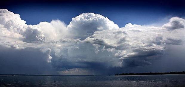
Photo Of The Day. Here is an awesome display of cumulonimbus, courtesy of Brad Birkholz. Details: "
A look at a cumulonimbus thunder shower that passed over Neenah, WI. Friday afternoon as seen from Kimberly Point Park."
 What The Heck Is This?
I'm no entomologist - and I haven't a clue what this thing is that
landed on the steps of my cabin. Any educated guesses out there?
"Shaka" Turns Your iPhone Into A Wind-Speed-Measuring Machine. Yes, every weather geek (um...enthusiast) should have at least one. More from
gizmag.com: "
If
you’re into activities such as windsurfing, sailing or kite-flying,
then you’re going to want to know where and how hard the wind is
blowing. While weather reports may give average wind speeds for your
city as a whole, they’re usually not very specific. That’s where Shaka
comes in. It’s a tiny wind meter that works with your iPhone. Shaka
plugs into the phone’s headphone jack. Once it’s held into the wind and
its blades start spinning, a paired app displays data such as wind
speed, direction and temperature, in real time."
 Sudden Urge For Mexican Food
. O.K. For the record, it's the "Fujita Scale". Close enough. Thanks to failblog.org.
 Enough Said
. Thanks to all the modern-day American heroes still serving overseas - you're very much in our thoughts and prayers.
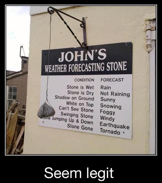 Works For Me
. Over the years viewers have sent me a wide assortment of "weather rocks". Hey, they work!

 Big Bug Alert
Why can't we train all those nasty (flying)
Asian Carp to devour mosquitoes? June monsoon season has brought a bumper crop
of mosquitoes and biting flies. Quality cabin-time has degenerated into a shouting slap-fest. Not good.
We shouldn't be surprised:
a hurricane's worth of rain soaked the Northland last week, a summer's worth of
moisture in less than 36 hours. One inch of rain falling on 1 square mile works out to 17.4 million gallons of water.
Assuming 500 square miles picked up at least 5 inches of rain, a very
conservative estimate, that equates to 43 billion gallons of water from Cloquet and Moose Lake to Two Harbors. An
incomprehensible amount of water.
A lack of deep topsoil (rocky
terrain) meant little of that rain could soak in - it quickly ran off into
streams, creating a muddy stain on Lake Superior visible from
space.
Tropical Storm Debby soaks Florida with 4-8" rain before
turning westward, possibly hitting Texas as a hurricane by
Wednesday.
We enjoy a (rare) dry spell. The big story this week: the heat. Mid 90s
return by midweek. Get ready for a Stinking Hot
Summer.
Already: 7 days of 90s. An average summer brings 14. This
summer? Predicting 20+.
Ugh.
Climate Stories...
 Here Come The Ticks: Is Global Warming Leading To An Increase In Lyme Disease?
I'm hearing from a lot of people that the tick population is much
higher this year than previous years - maybe the result of our
non-existant winter, coupled with recent heavy rains? Not sure, but this
article at
scienceblogs.com caught my eye; here's an excerpt: "
Climatologists have been warning us about the ongoing and impending consequences of global warming
for years. But the results of climate change affect more than just
polar bears and penguins – if you live anywhere in the northeastern,
north-central or west coast states of the U.S.., you could be at a
greater risk for contracting Lyme Disease. Lyme disease is an infection of the Borrelia burgdorferi bacterium that is spread through black legged ticks (otherwise known as deer ticks) who feed on the white footed mouse
species, also known as the wood mouse, which carries the bacteria. The
symptoms of the disease itself include fever, headache, fatigue, and a
telltale “bulls eye” rash near the site of the tick-bite. Left
untreated, Lyme disease can spread to affect the joints (causing
arthritis), heart, and nervous system – often causing irritability and
mood swings." Photo above courtesy of
wikipedia.
 Better Buildings Can Combat Climate Change
.
Retrofitting older, far less efficient commercial buildings, will be
big business in the years ahead; here's an excerpt of a story at
canada.com: "
As
the globe grapples with ways to reduce
greenhouse gas emissions and energy consumption to mitigate the effect
of climate change, much of the attention has focused on automobiles and
industry as the culprits. In fact, it may be surprising to know that the
single largest contributors to climate change are buildings. According
to the U.S. Energy Information Administration (EIA), industry
contributes almost 20 per cent of America’s yearly greenhouse gas
emissions; the transportation sector is responsible for 33 per cent and
buildings emit fully 47 per cent of GHGs."
Photo credit above: B+H BuntingCoady.
Global Carbon Emissions Rise Is Far Bigger Than Previous Estimates. The story from
The Guardian; here's an excerpt: "Carbon dioxide emissions have risen by even more than previously thought, according to
new data analysed by the Guardian,
casting doubt on whether the world can avoid dangerous climate change.
The data has emerged as governments met in Rio de Janeiro to finalise
the outcome of the
Rio+20 conference, aimed at ensuring that economic growth does not come at the expense of irreparable environmental degradation, but which
activists say has not achieved enough to stave off severe environmental problems. Global
carbon emissions from
energy are up 48% on 1992, when the original Earth summit took place in Rio – a
historic summit at which governments agreed to limit emissions in order to prevent dangerous climate change."
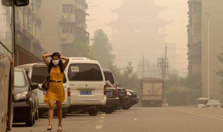
Photo credit above: "
A hazy day in Wuhan, China, the country that has experienced a 240% increase in carbon emissions between 1992 and 2010." Photograph: Darley Shen/Reuters.
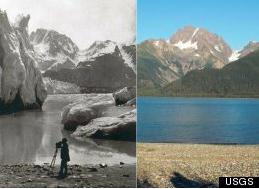
"This Is Climate Change" Photo Series Show Dramatic Effects Of Global Warming (Photos). Here's an amazing photo slide show highlighting the impacts of a warming world, courtesy of
Huffington Post: "
Climate
change is one of the hottest issues of our time, and nothing helps
tell the story like photos. The Del Mar Global Trust, a private
charitable foundation with a focus on environmental issues, has started
a website called "This Is Climate Change" as part of an awareness-raising initiative. Its focal point is a series of powerful then-and-now photos that documents arctic and antarctic ice melting, mountain pine beetle infestation, and glacial retreat."
Photo credit: USGS.
The Most Anti-Environment Congress In History: Here's The Record. From
The Huffington Post; here's an excerpt: "
Global
temperatures are rising, violent weather is increasing; chemicals in
the air, food supply and water might be leading to soaring rates of
allergies, asthma, certain cancers, hormone disruption, male
infertility. Forest lands are vanishing at unprecedented rates, vast
dead zones are spreading in the world's oceans, we are running out of
non-renewable fossil fuels. Everyone knows that we are facing an
unprecedented environmental crisis -- right? Wrong. This news seems
never to have gotten through to America's Republican legislators. In
the face of these huge and escalating threats, the GOP majority over
the last year has voted no fewer than 247 times (nearly once a day for
every day the House was in session) to weaken environmental
protections that have been in place for decades and to defeat needed
legislation."
The joys and perils of air conditioning....
We've Forgotten Natural Cooling. Air conditioning is
a). expensive, and b). an energy sink that ultimately pumps more
greenhouse gases into the atmosphere. Here's an excerpt of an
interesting Op-Ed at
The New York Times: "
Air-conditioning
is a 20th century idea. Our early ancestors avoided the heat by
retreating into the cave or the shade of a tree, and engaging in
strenuous activity only during the cooler or breezier part of the day.
Early vernacular buildings developed using these universal principals,
carefully orienting and shading buildings so that they gained heat in
winter and were shady in summer, introducing thermal mass in dry
climates, and in more humid ones using cross ventilation, porches,
shutters, ceiling fans, solar chimneys and insulation."
Crucial To Modern Life. Another perspective in this Op-Ed at
The New York Times; here's an excerpt: "
Air-conditioning
is a necessary luxury. For thousands of years before the invention
of air-conditioning in 1902, humans survived high heat and humidity by
constructing protective shelters and limiting their activity during
the hottest times of the year. Air-conditioning puts us in control of
our comfort and frees us from the discomfort, risk and uncertainty of
the weather. The availability of air-conditioning allows architects to
consider building geometries that were not possible when it was
critical that everyone be seated near a window. This allows larger
floor plates that encourage collaboration and permit the high densities
of our modern cities."
Study: Southern California Could See Record Scorchers. The article from Silicon Valley's
mercurynews.com; here's an excerpt: "
The
study was commissioned by the city and conducted by UCLA's Department
of Atmospheric and Oceanic Sciences. It downscaled global climate
change computer models to the local region, breaking down predictions
to 1.2-mile segments, and is 2,500 times more precise than previous
climate models for the region, researchers said. They said dense urban
areas such as downtown Los Angeles probably will warm an average of 4
degrees, with a warming range of up to 6 degrees in the Mojave Desert.
The number of days where the temperature tops 95 degrees
could triple in downtown Los Angeles and jump five-fold in the
deserts, according to the study, while the hottest days could be
record-breakers."
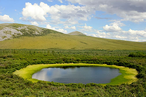
Climate Change Clues Found In Remote Siberian Lake. Here's an excerpt of an interesting story at
Kansas City Infozine: "
Intense
warm climate intervals--warmer than scientists thought possible--have
occurred in the Arctic over the past 2.8 million years. That result
comes from the first analyses of the longest sediment cores ever
retrieved on land. They were obtained from beneath remote, ice-covered
Lake El'gygytgyn (pronounced El'gee-git-gin) ("Lake E") in the
northeastern Russian Arctic. The journal Science published the findings
this week. They show that the extreme warm periods in the Arctic
correspond closely with times when parts of Antarctica were also
ice-free and warm, suggesting a strong connection between Northern and
Southern Hemisphere climate."
Image above: NASA.
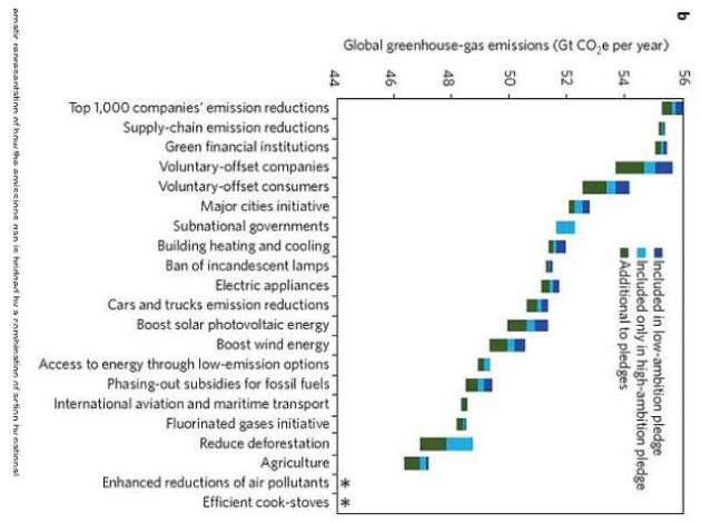
Tackling Global Warming In 21 Easy Steps. Ezra Klein
takes a look at what the global community can do (collectively) to
prevent a 2 C warming in the coming years; here's an excerpt from his
story at
The Washington Post: "...
What
are these policies? To some extent, they’re things that people are
already doing. Many of the 1,000 largest greenhouse gas emitters in the
world have already pledged to reduce their emissions through
money-saving efficiency measures. If an organization like the World
Business Council could somehow lead just 30 percent of these companies
to cut their energy emissions 10 percent by 2020, that would add a
significant chunk of the needed cuts. Another chunk of cuts could come
from companies like Wal-Mart that have pledged to “clean up” their
supply chains. Likewise, the world could get more emissions chunks if
all of the hundreds of cities that have pledged to cut emissions around the world actually followed through on their promises."
Graph credit above: Blok et al. "
Bridging the greenhouse-gas emissions gap" Washington Post.
Commentary: Climate Change Isn't Fictional. Here's an excerpt of an Op-Ed from Appleton's
Post Crescent: "
Is
it just me, or has it been a little warm around here lately? Or
warmer earlier? The early and unusually mild spring here in Wisconsin
may be nature’s way of reminding us that the clock is ticking on
climate change and we need to take action before it’s too late.While
stationed in Kangerlussuac, Greenland, 50 years ago, I noted my airbase
was 4 miles west of the Russell Glacier grinding down from the ice
cap. Looking at today’s satellite images, this glacier has retreated
to the east toward the ice cap, easily noted from the satellite. The
retreat averages 1,000 feet per year, producing a torrent of melt
water that flows down the fjord and to the sea."
Going Green. Here's an excerpt from an Op-Ed at
The New York Times: "
Back
in 1987, when we set up our consulting company called SustainAbility,
no one knew the word. For years we had to spell out the name. Today,
according to a 2010 Accenture survey of 766 chief executives
worldwide, 93 percent see sustainability as important for the future
of their businesses, 88 percent accept that they must drive new
requirements through their supply chains, and an astonishing 81 percent
say they have already integrated sustainability into their businesses."


