Thanks to my good friend Amanda Granning for this picture out of Duluth, MN.
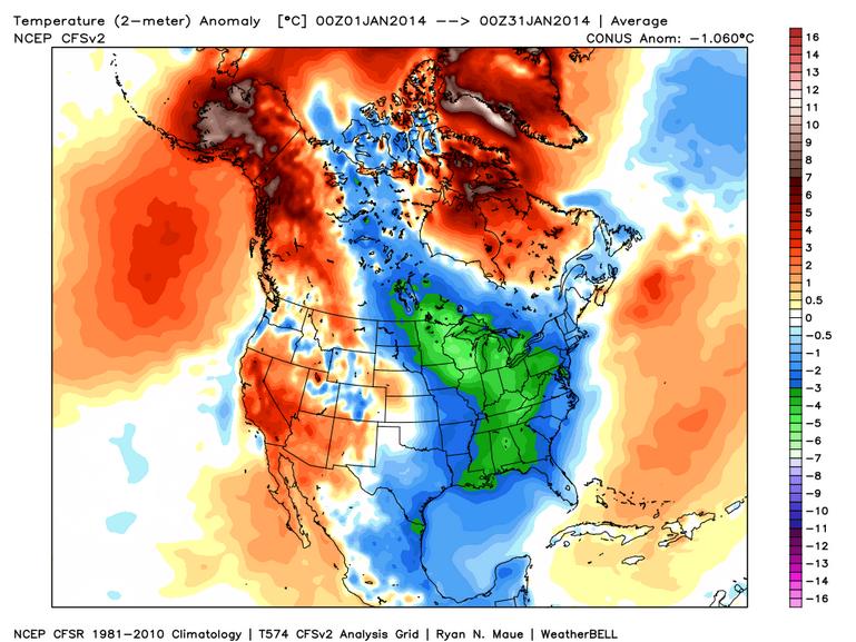
It's Been a Cold JanuaryThanks to WeatherBell.com for the image below, which shows the temperature anomaly for the month of January. Note how cold it was for the eastern half of the country, while the western half of the country and Alaska was well above average for the month!
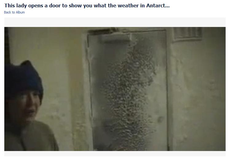
Condition 1 Weather
It could be worse! This is from Antarctica last April 2013 and it has been making the rounds on Facebook. I guess I've never heard of this until now... "Conditions 1 Weather" in Antarctica where travel outside in not permitted when these conditions are in place! Check it out, it's CRAZY!
See the video from Sun Gazing & FrozenSouth.com HERE:
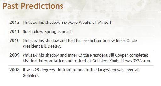
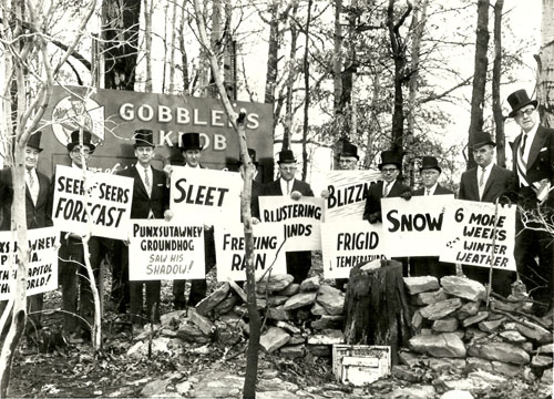
Groundhog Day 2014
The time has come for the famous groundhog from Punxsutawney, Pennsylvania to work his magic. At 7:20am EST on Sunday, Phil will emerge from his heated den and give us a forecast regarding our winter fate. Here's to hoping he knows something we don't & for an early Spring!
Here are some of the past predictions from groundhog.com:
See more from groundhog.com HERE:
(photo courtesy: groundhog.com)
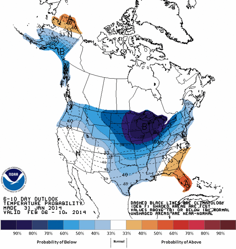
Temperature Outlook
According to NOAA's Climate Prediction Center, the 6 to 10 day temperature outlook into early/mid February shows a good chance of much below average temperatures spreading throughout much of the Midwest. Cooler than average temperatures will also be possible for most of the nation as well during this time frame.
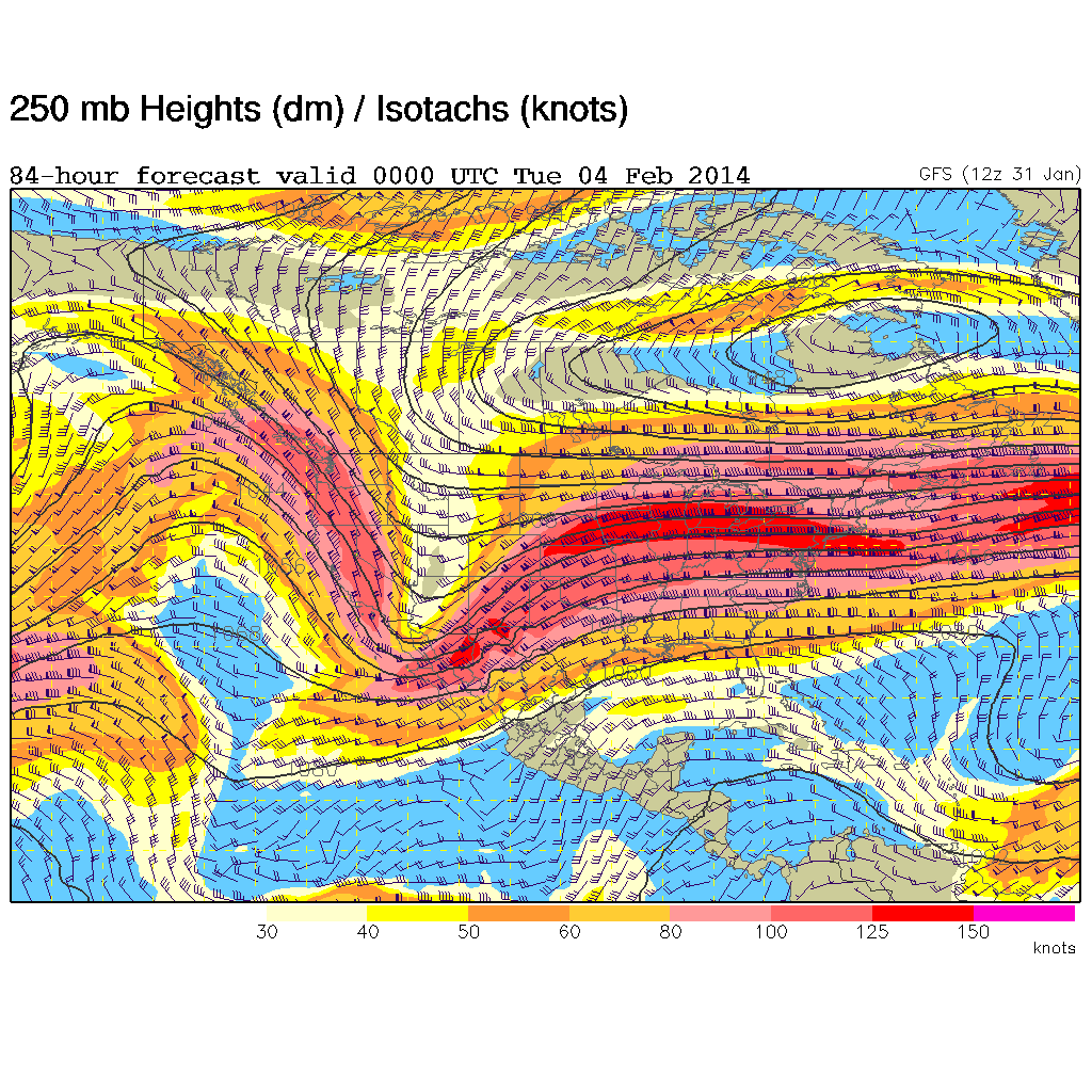
Upper Level Winds
Here is the upper level wind pattern for Monday. Note the circular pattern just east of the Hudson Bay, this is still an area of low pressure helping to churn down Arctic air into the Lower 48. The good news is that the strong upper level winds have shifted a bit to become more "Zonal" or more west to east, which is not only helping to moderate temperatures across the southern half of the country, but it is also helping to bring in moisture to the western half of the country!
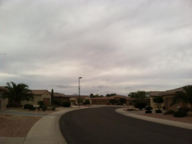
Rare Cloudy Day in Phoenix, AZ
Thanks to Jody Musil for this image out of Surprise, AZ where on Friday, there was a fairly substantial cloud deck in place, but still no rain.
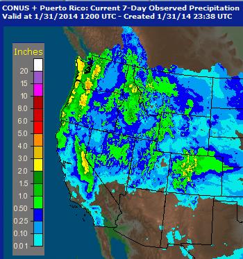
Precipitation Past 7 Days
This is sure nice to see. Take a look at all the precipitation that we've seen over the past 7 days in the western U.S.. This is certainly more than we've seen over the past several weeks!
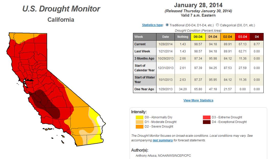
Still Too Dry in California
This is the first time in recorded history that any part of the state of California has entered a state of EXCEPTIONAL DROUGHT and nearly 9% of the state is considered to be in this classification.
"Drought and relatively mild temperatures continue to prevail across the state. In the northwestern part of California, a 1-category degradation from severe to extreme drought (D2 to D3) was made across Humboldt and Trinity Counties. The Central Sierra Snow Lab near the Donner Summit reports 8 inches of snow on the ground, the lowest for this time in January since at least 1946. In the general vicinity of Monterey to Bakersfield, conditions warranted a 1-category downgrade, from extreme to exceptional drought (D3 to D4). A few of the impacts within the D4 area include fallowing of land, wells running dry, municipalities considering drilling deeper wells, and little to no rangeland grasses for cattle to graze on, prompting significant livestock sell off."
See more from the U.S. Drought Monitor HERE
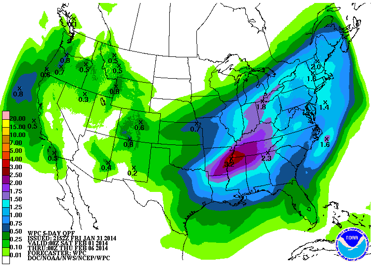
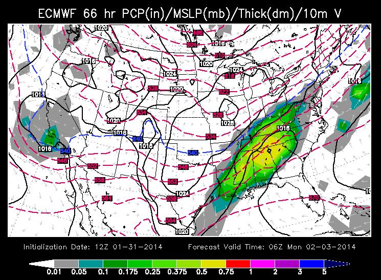
Precipitation Potential
According to NOAA's HPC 5 day precipitation forecast, there's still a decent chance of moisture across the western part of the country, but note the more substantial moisture across the nation's mid section. The precipitation on the northern flank of this moisture swath is going to be a mixed bag of wintry precipitation, some of which will be in the form of heavy snow.
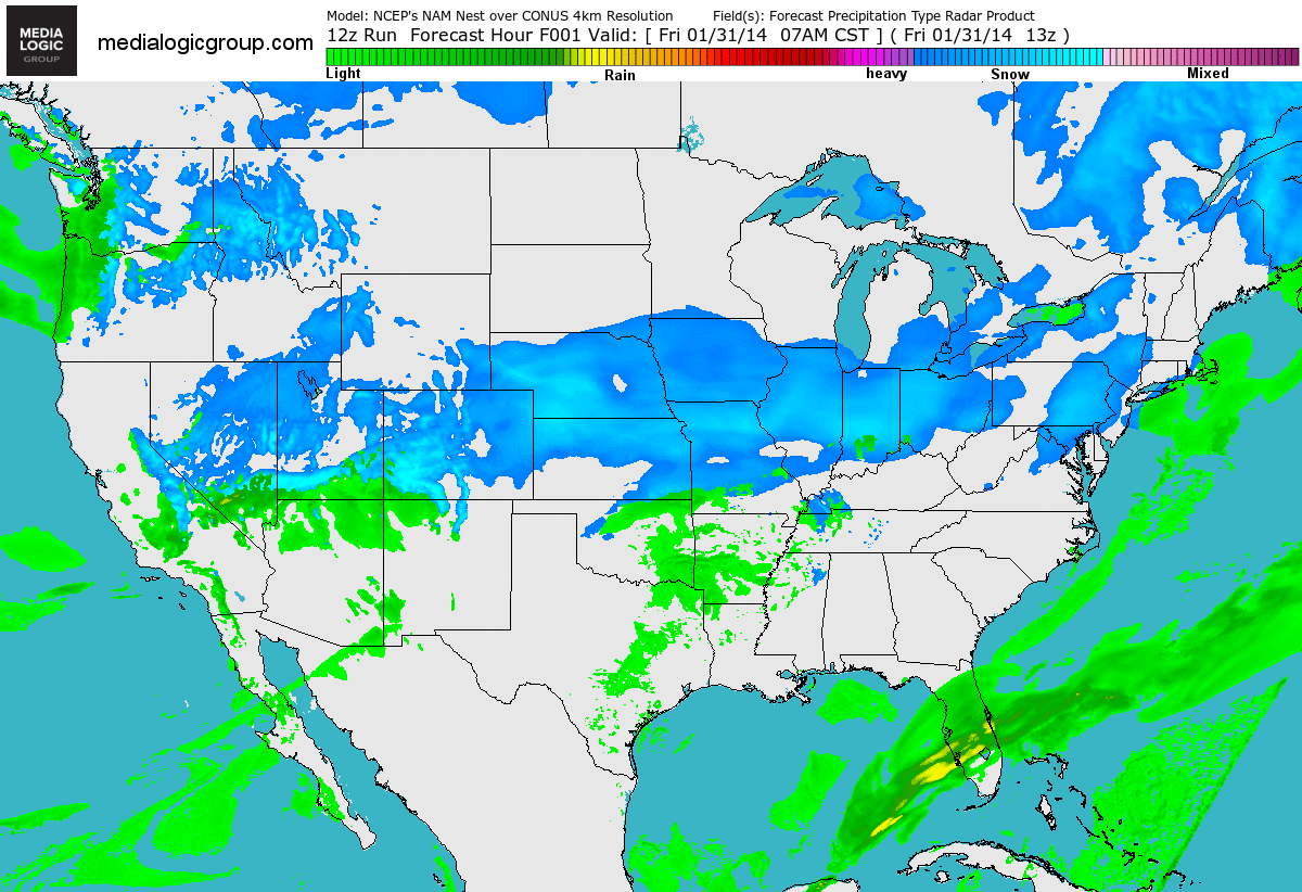
Precipitation Outlook
Take a look at the futurecast radar from AM Friday into Sunday. Note Saturday appears to be the most significant day for heavy snow potential across parts of the Central Plains to the Great Lakes Region.
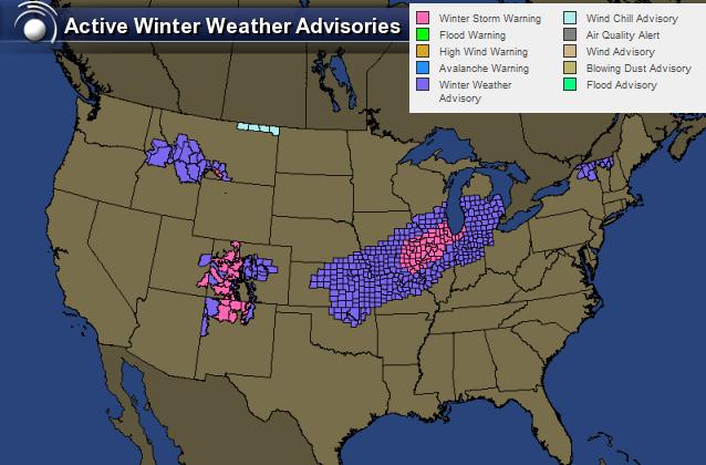
Winter Weather Concerns
Here's a national look at the winter weather headlines; note the winter weather headlines from Central Plains to the Great Lakes. This is where heavy snow will be possible through the early weekend.
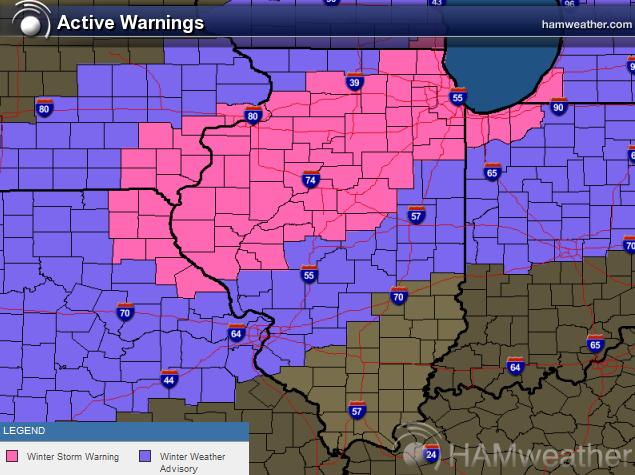
Winter Storm #1
Yes, this will be a significant winter storm for areas shown below... interestingly, there could be another big winter storm early next week! Here are the winter storm warnings (pink) through Saturday. Here's the latest winter weather update from the National Weather Service in Chicago.
...WINTER STORM WARNING REMAINS IN EFFECT FROM 9 PM THIS EVENING TO 6 PM CST SATURDAY...
* SNOW WILL DEVELOP LATE THIS EVENING AND INCREASE IN INTENSITY AFTER MIDNIGHT WITH A PERIOD OF HEAVY SNOW POSSIBLE DURING THE MID TO LATE MORNING HOURS OF SATURDAY. THE SNOW WILL END BY EARLY SATURDAY EVENING. SOME SLEET AND FREEZING RAIN MAY MIX WITH THE SNOW SOUTH OF A LINE FROM OTTAWA TO JOLIET TO MIDWAY AIRPORT.
* STORM TOTAL SNOW ACCUMULATION 6 TO 10 INCHES. STORM TOTAL ICE ACCUMULATION UP TO ONE TENTH OF AN INCH...SOUTH OF A LINE FROM OTTAWA TO JOLIET TO MIDWAY AIRPORT.
* SNOWFALL RATES OF ONE TO TWO INCHES PER HOUR ARE POSSIBLE MID MORNING SATURDAY.
* SNOW COVERED ROADS AND LOW VISIBILITIES WILL MAKE TRAVEL HAZARDOUS FROM LATE THIS EVENING THROUGH EARLY SATURDAY EVENING.
* TRAVEL THROUGH CHICAGO O`HARE AND MIDWAY AIRPORTS COULD ALSO BE SIGNIFICANTLY IMPACTED.
Winter Storm #2
Another storm will quickly develop from late weekend into early next week. Snowfall potential with this particular storm will sag a little farther south than the first one.
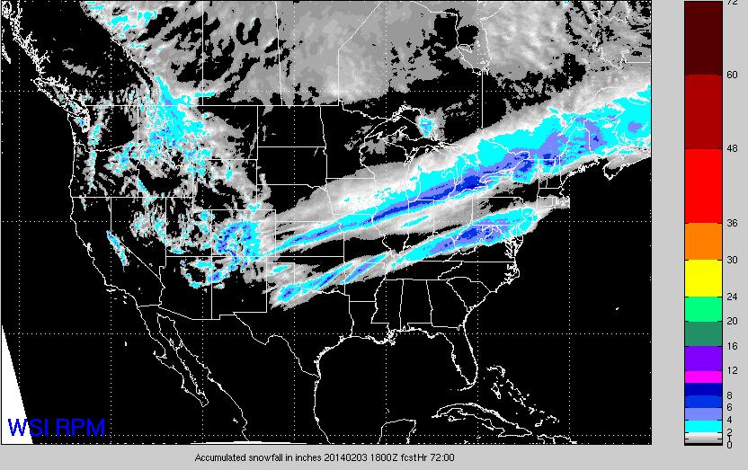
Snowfall Potential With Storm #1 & Storm #2
Here's an outlook on snowfall potential through early next week, which includes the snowfall potential from the first two snow events.
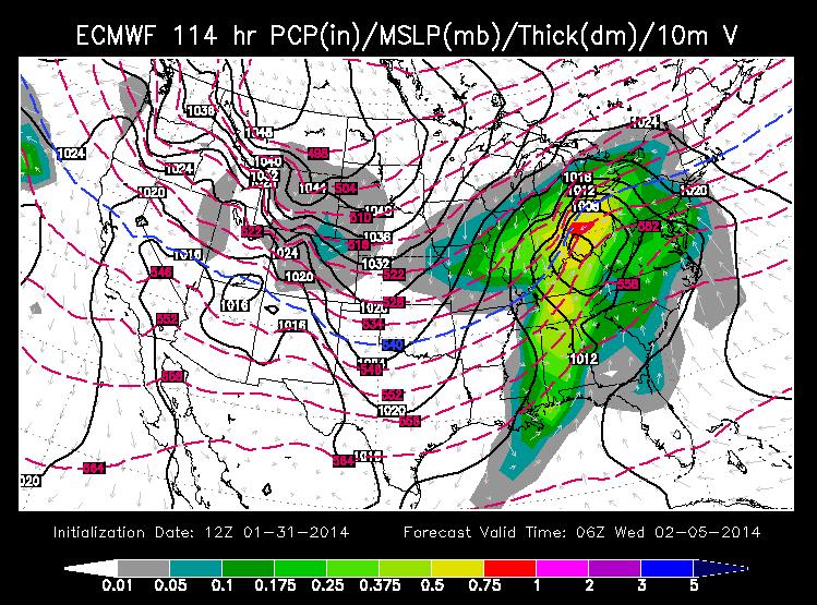
Winter Storm #3
Here's a brief update on the potential winter storm for the early/middle part of next week. Note the near same track that storm #1 will be taking. This particular storm system will also bring the potential of heavy snowfall to some of the same areas seeing snow with storm #1. The important thing to note is that this particular storm system isn't even over land yet, so exact precipitation amounts/type and placement of the storm are still uncertain... Stay tuned for more
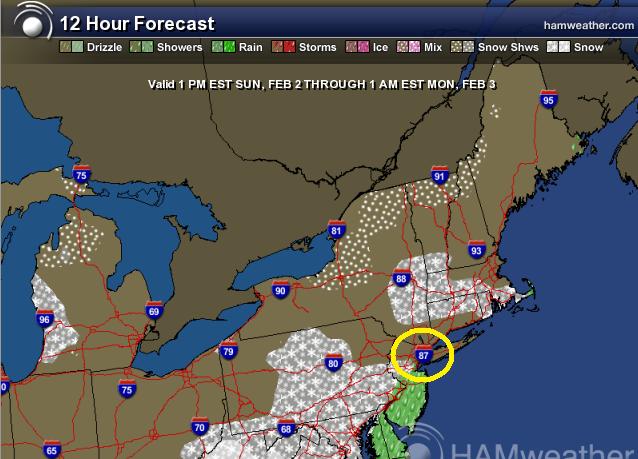
A Super Super Bowl Forecast?
It's not quite the doom and gloom forecast that may have been portrayed premature forecasts from late last fall/early this winter, but we certainly have dodged a bullet. With the winter storm that unfolded in the eastern half of the nation last weekend and with the seemingly more active pattern now, the forecast could have been worse no doubt! The forecast image below from 1pm Sunday to 1am Monday suggests that we may just skip away with a mostly dry Sunday evening.
While there is a little a little rain in the forecast for Sunday morning and a little rain/snow mix for overnight Sunday/early Monday morning, the Sunday evening forecast appears to be mostly dry.
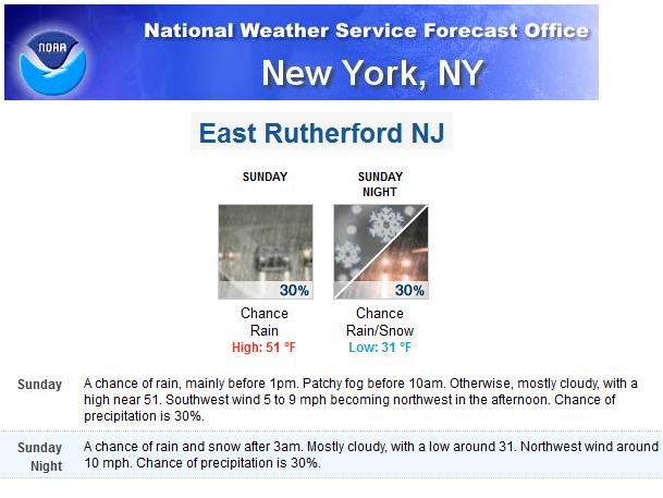
Here's the official forecast from the National Weather Service from New York, NY for East Rutherford, NJ on Sunday.
Thanks for checking in and have a great weekend ahead!
Twitter: @TNelsonWNTV