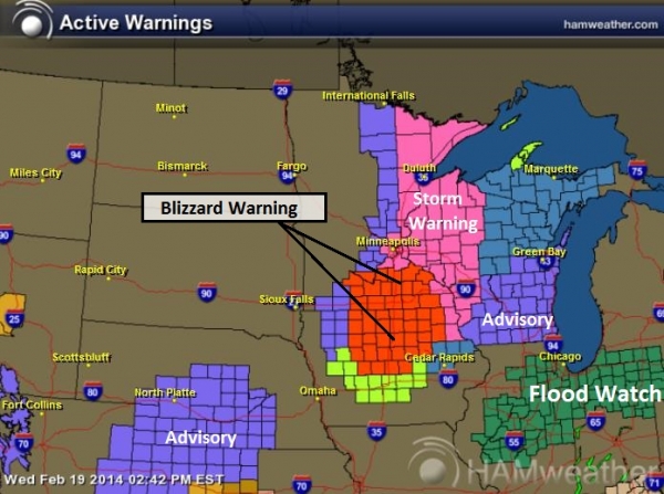
Little Siberia
Minnesotans
are a tough, resilient bunch. On a morning like this I guess that's
self evident. We grudgingly tolerate a few arctic fronts, in return for
living in a magical land, one immune to earthquakes and hurricanes.
In
1885 a smug New York City reporter described St. Paul as "another
Siberia, unfit for human habitation in winter". The next year city
elders launched the first Winter Carnival, to prove to the world that
winters at this latitude are magical and memorable.
Proving my theory that those who can - do. Those who can't - criticize. Or consult.
King
Boreas will get the last laugh this year; no melting in Rice Park until
further notice. Although not a Top 15 Coldest January, this may wind up
being the chilliest since 1997, but a far cry from the frigid winter of
1977.
We've seen subzero AND 30s - huge temperature swings whipping up strong winds capable of ground blizzards.
The
pattern is brutally persistent; colder than average into at least
mid-February, but not the polar, school-closing cold of recent days.
20s return tomorrow. Anywhere else in America that would qualify as bitter. Here, after our recent spell of Nanook?
Sounds like sweet relief to me.
* file photo credit
here.
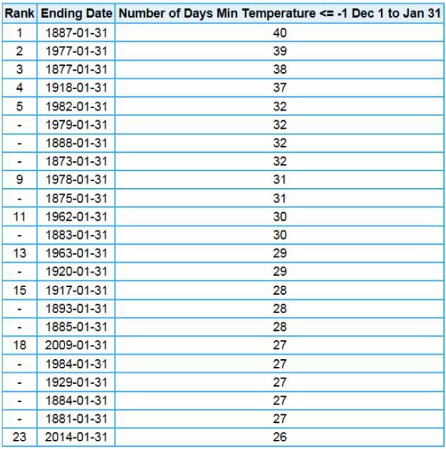
26 Subzero Nights Since December 1. The Twin Cities National Weather Service
has details on the subzero spell since late 2013; 26 nights dipping
below zero since December 1, 2013. That compares to 40 nights in 1887
and 39 nights in 1977.
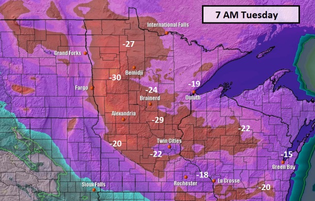
Numb And Number.
I still haven't received a satisfactory answer to my (purely
rhetorical) question: "is it possible to feel colder than numb?" When
it's this cold you get to numb faster, I guess. Suburban temperatures
dip to -20F or colder before recovering close to 0F by late afternoon.
At least the winds have eased up a bit. Map: 2-meter NAM data from NOAA
and Ham Weather.
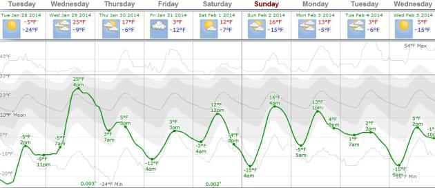
Slight Recovery.
No warm fronts or chirping robins anytime soon, but the core of the
polar air retreats north, leaving us with seasonably cold weather into
the first week of February. As long as steering winds are blowing out of
western Canada it will be tough (impossible) to get significant
moisture from the Gulf of Mexico into Minnesota. Graph: ECMWF forecast
data for MSP from Weatherspark.
6 More Weeks Of Winter? Count On It.
I have no doubt the ground hog will see his shadow on Sunday, impling
"6 more weeks of winter". I see no quick reversal in the (stuck) cold
weather pattern that has gripped the northern tier of the USA since
early December. Highs reach single digits and teens the first week of
February. Cold, but not quite as polar.
Ski Wilmington, North Carolina?
The latest surge of Arctic air spins up a storm along the Gulf Coast,
dropping ice and slushy snow as far south as New Orleans, Mobile and
Pensacola, maybe a few inches for Augusta, Georgia, as much as 4-8" for
parts of the coastal Carolinas. NAM data: NOAA and Ham Weather.
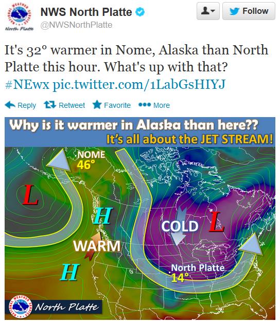
Thawing Out In....Alaska?
The pattern, for at least 2 months now, has been stubbornly resilient,
with a bloated ridge of high pressure over the western USA, and jet
stream winds consistently buckling, sending one surge of polar pain
after another into the northcentral USA. A Conga-line of cold fronts. In
today's
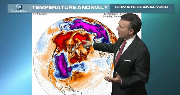
Climate Matters we examine an odd pattern responsible for mild, snow-free weather over parts of Alaska: "
WeathernationTV
Chief Meteorologist Paul Douglas looks at one of the few places in the
United States experiencing a tropical heat wave. It just happens to be
above 60°N latitude. Alaska is seeing temperatures well above normal
while much of the Lower 48 is seeing bitterly cold temps. And the all
important question on everyone's mind, what's the weather going to be
like for the Superbowl?"
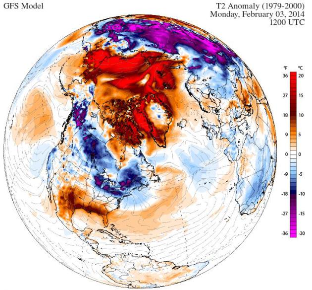
Upside-Down Weather Map.
The map above shows temperature anomalies over the northern hemisphere
next Monday, February 3, showing cold, but not polar air from Minnesota
into New England. Note the unusually mild weather from Alaska into much
of northern Canada and the Arctic. Credit: Climate Reanalyzer.
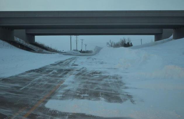
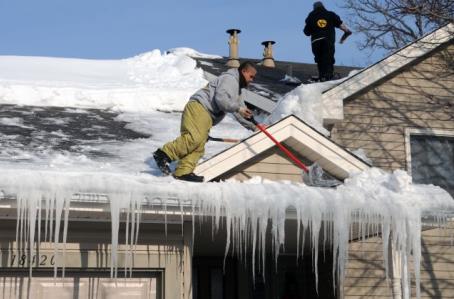
Stay Out Of The Right Lane. 6-8 foot drifts courtesy of the Waseca County Sheriff's Office.
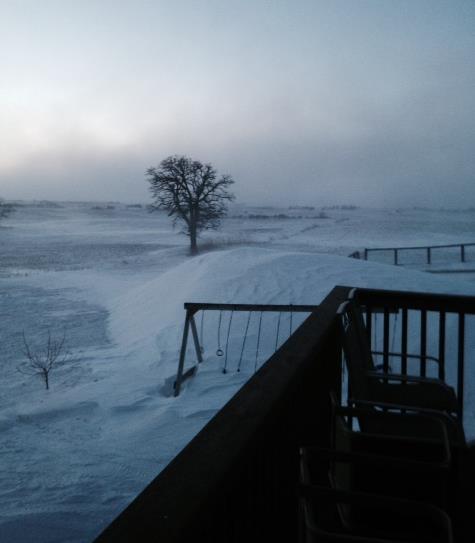
Swingset-Gobbling Drifts.
This is what can happen out in open country, when consistently high
winds can swirl snow in a single location - check out the height of the
snow drift in relation to the swing set. This picture was taken in
Ossian, IA, courtesy of Carol Schnuelle.
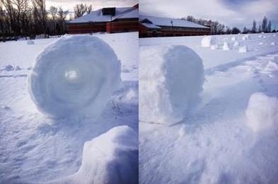
"Snow Rollers". Look what high winds whipped up near Worthington, Ohio. Rare snow rollers, courtesy of Chris Baggs.
"Ask Paul". Weather-related Q&A:
Hi Paul,
Do
you remember the “Silver Icicle Award” that was printed in the Star
Tribune after the terrible January of 1977? We had just moved back to
Minneapolis from sunny San Jose, California, so it felt particularly
brutal and cruel. When we left, there was a drought in California and
all the reservoirs were at very low levels. Déjà vu all over again.
There
were five days of record lows that January, two days of near record
lows, a high on 33 on January 23, followed by a plunge to a wind chill
low of -70 on Friday, January 28. Then Governor Rudy Perpich declared an
energy emergency, asked for a 4-day work week and for thermostats to be
set at 65 daytime and 60 at night. On the 26th, President Jimmy Carter
asked Congress for energy emergency legislation.
Isn’t it time
for another “Silver Icicle Award”? I clipped and saved the award from
1977. It is one of my proudest achievements to have survived that brutal
January of 1977 and if the Star Tribune would publish another award
after this January final ends, I would do the same.
Bob Brown, Bloomington, MN
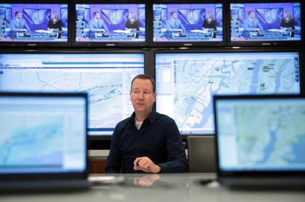
Super Bowl Already Putting Big Pressure On A Weatherman. I feel for this guy - I really do. Nobody wants to get this forecast wrong, as described by
The New York Times; here's the intro: "
There
comes a moment in so many memorable games when a team will turn its
anxious gaze to one player and ask a simple question: You got this
covered? In the National Football League, it is likely to be the kicker,
quarterback or running back. On Sunday, it was the weatherman. At 8
a.m., John Bateman, a meteorologist hired by the league, made his first
presentation to some two dozen executives who are looking to him to tell
them what to expect on Super Bowl Sunday..."
Photo credit above: "John Bateman, a meteorologist, at National Football League headquarters in New York." Michael Appleton for The New York Times.
Alerts Broadcaster Special Product for Super Bowl Sunday: Issued Monday afternoon, January 27, 2014.
Here is what has changed since Sunday's update:
* I still don't see a blizzard or major storm for the New York City area next Sunday.
*
The chance of rain/snow showers has risen for Saturday night into early
Sunday morning for East Rutherford, but skies should start to clear by
midday and afternoon Sunday with dry conditions expected for the game.
*
Temperatures should be in the low to mid 30s at MetLife Stadium by late
afternoon and evening with a northwest breeze at 10 mph. Considering
the possibilities in early February - not a bad outcome at all.
*
No problems getting into NYC airports Friday or Saturday morning, or
getting out of town Monday. A rain/snow mix may spread into New York
late Tuesday, changing to all rain next Wednesday as highs surge into
the 50s.
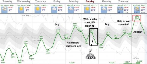
Super Bowl Planner.
Tuesday will be the coldest day in north Jersey with highs in the teens
and a windchill near zero. Avoid the urge to panic - it will warm up
significantly by next weekend. The arrival of a weak cool front may
spark rain/snow showers Saturday night, spilling over into the morning
hours Sunday - a little slush can't be ruled out on secondary roads and
parking lots, but I still expect mainly wet roads around metro New York
City and northern New Jersey. Skies should try to clear Super Bowl
Sunday during the afternoon and evening, with dry weather spilling over
into Tuesday morning. Graphic: Weatherspark.
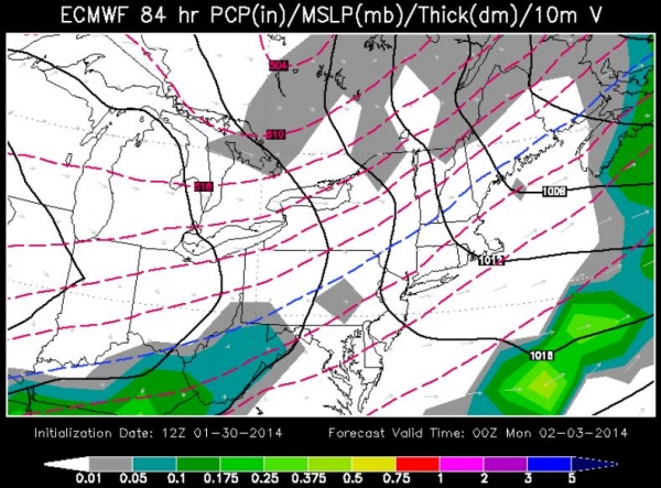
Predicted Weather Map Sunday Evening.
This is ECMWF guidance, valid 7 pm EST Sunday evening, suggesting
partly to mostly cloudy skies in the New York City area, snow probably
no closer than Chicago and Detroit. Map above: WSI Corporation.
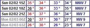
Sunday Numbers.
GFS data shows temperatures peaking around 38-40F early Sunday
afternoon, then falling slowly through the 30s, probably 31-33F for
gametime with a northwest breeze at 7-12 mph. In the Pantheon of
Potential Weather Horrors, this is pretty close to a best case scenario.
Summary:
It's still a bit early to celebrate, but the longer we go, with
computers in fairly good agreement, the higher our confidence level
grows that we probably won't see debilitating weather for Super Bowl
Sunday. A few nuisance rain/snow showers will push across the New York
City area Saturday night, and Sunday may get off to a wet start. But
skies should brighten by midday over MetLife Stadium, with gradually
improving weather and a few sunny spells by afternoon as temperatures
slowly sink through the 30s. A more significant period of rain/snow may
arrive by midday Tuesday, changing to all rain next Wednesday, but the
window of Sunday into Monday looks fairly quiet, by New York standards
in early February. Let's get a few more computer runs under our belt -
then maybe I can start to exhale by midweek. Stay tuned...
Paul Douglas - Senior Meteorologist - Alerts Broadcaster
Alerts Broadcaster Briefing: Issued Monday morning, January 27, 2014.
*
Period of rain, changing to freezing rain (glaze ice) then finally snow
from Tuesday PM into Wednesday PM, from near New Orleans and Mobile to
Pensacola, Augusta, Savannah, Hilton Head, Myrtle Beach, Wilmington and
Outer Banks.
* Atlanta may see a coating of slush, maybe 1-2" south of ATL, but heaviest snow/sleet/ice bands should stay south of Atlanta.
* Amounts may be "plowable", especially eastern North Carolina (heaviest bands probably staying east of Charlotte and Raleigh).
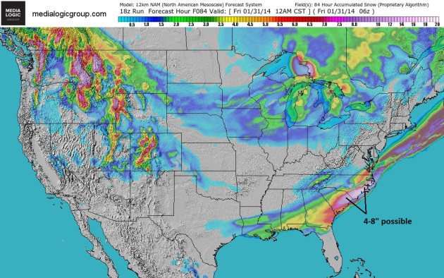
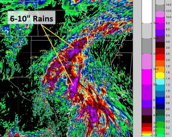
Big Picture.
A swirl of low pressure tracking along the leading edge of the latest
polar airmass to invade the USA will drop a slushy, icy concoction
within 100-150 miles of the Gulf Coast, with the greatest potential
travel issues Tuesday evening into Wednesday morning from Lake Charles
to Gulfport, Mobile, Pensacola and Destin, spreading across southern and
central Georgia into the coastal Carolinas during the day Wednesday.
Unusual? Yes, but hardly unprecedented. NAM snowfall: NOAA and Ham
Weather.
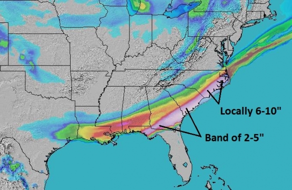
High-Res Solution.
Another model we trust prints out a coating of slush (and glaze ice)
from near Mobile to Pensacola, some 2-4" amounts for southeastern
Georgia, withh the heaviest amounts for eastern North Carolina,
including the Outer Banks, where some 6"+ amounts can't be ruled out by
Wednesday night. RPM model data: WSI Corporation.
Winter Storm Watches In Unlikely Places.
NOAA has issued a Winter Storm Watch from Houston to Lake Charles, New
Orleans, Mobile and Pensacola, extending into much of Georgia and the
Carolinas by Wednesday, for a combination of freezing rain (glaze ice -
rain freezing on contact with cold surfaces), sleet (ice pellets),
ending as a little wet snow. The primary threat for the Gulf Coast is
ice, topped off with a coating to 1" of slushy snow by Wednesday
morning. Map:
Ham Weather.
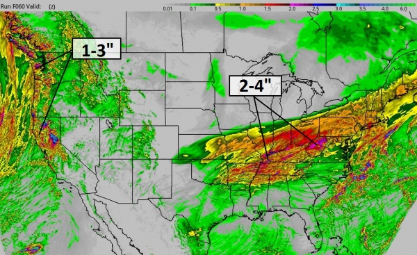
Greatest Snowfall Potential: North Carolina.
The heaviest snow bands are forecast to set up east of Raleigh, which
is right on the edge of the Winter Storm Watch. Right now I do not
expect widespread travel problems between Charlotte and Raleigh, but
accumulating snow and ice is likely from Wilmington and Myrtle Beach to
New Bern, Greenville and The Outer Banks.
Wednesday Morning.
Wake-up temperatures by midweek dip below zero across a huge swath of
the USA, colder than 32 from New Orleans to Pensacola to Savannah. New
York City suburbs will see single digit lows early Wednesday, as cold as
-4 Detroit and -5 Chicago, with double digit negative numbers from
Madison to the Twin Cities and Duluth. NAM guidance: NOAA and Ham
Weather.
Summary: Never a dull moment, not this
winter. While interest grows in Super Bowl weather conditions at MetLife
Stadium in East Rutherford, New Jersey for Sunday, the short-term
threat will be ice and snow from the Gulf Coast into the Carolinas.
Atlanta should be spared a major accumulation; latest 12z models hinting
at 1" of slushy snow Tuesday night for KATL. We'll keep an eye on this
system and update you on Super Bowl weather, in the event some of your
are lucky enough to have tickets to the big game. Otherwise the weather
should be just fine in your family room for Sunday's Big Spectacle.
Paul Douglas - Senior Meteorologist - Alerts Broadcaster
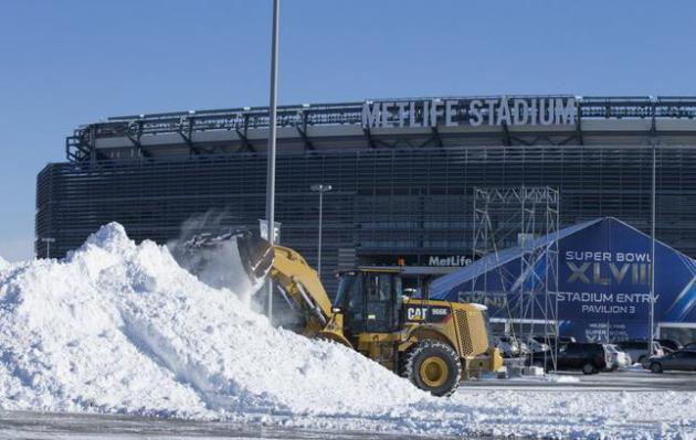
The Greenest Super Bowl Ever? Here's a clip from an AP story at
ABC News: "...
Greening
the Super Bowl has been a passion project for Groh, who started out as a
journalist before forming an environmental communications firm with his
wife. He did his first work for the NFL at the 1994 Super Bowl in
Atlanta, at a time when the simple recycling of plastic bottles and cans
at stadiums was a significant step forward. He continuously seeks out
new ways to wring as much value out of things that normally would be
discarded. For example, in the weeks leading up to this year's Super
Bowl, the NFL sponsored e-waste recycling events in New York and New
Jersey that collected 9,000 pounds of old phones, computers and other
gadgets, according to Verizon, which partnered in the program..."
Photo credit above: "
Snow
is cleared from the parking lot of MetLife Stadium, which will host the
Super Bowl, in East Rutherford, N.J., Jan. 22, 2014. On Jan. 26, a
meteorologist hired by the NFL made his first presentation to some
two-dozen executives who are looking to him to tell them what to expect
on Super Bowl Sunday." (Fred R. Conrad/The New York Times).
Caffeine Can Enhance Memory, New Research Suggests. Well here's a golden ray of good news on an otherwise blah Tuesday, courtesy of
Gizmag: "
Caffeine
is one the world’s favorite productivity fuels and in many countries
people choose a caffeinated drink, mainly coffee, to ignite the day.
Although some people rightly worry about over-consuming the stuff,
findings of a new study suggest that a moderate daily dosage may enhance
our memory. The research carried out at Johns Hopkins University
indicates that caffeine can help the brain retain information we study
during a period of up to 24 hours subsequent to consuming it..."
Photo credit: Shutterstock.
Climate Stories....
Global Temperature 2013. Here is an update on recent data providing some global perspective for 2013, from
Real Climate: "
The
global temperature data for 2013 are now published. 2010 and 2005
remain the warmest years since records began in the 19th century. 1998
ranks third in two records, and in the analysis of Cowtan & Way,
which interpolates the data-poor region in the Arctic with a better
method, 2013 is warmer than 1998 (even though 1998 was a record El Nino
year, and 2013 was neutral)...."
The global temperature data for 2013 are now published. 2010 and 2005 remain the warmest years since records began in the 19th Century. 1998
ranks third in two records, and in the analysis of Cowtan & Way,
which interpolates the data-poor region in the Arctic with a better
method, 2013 is warmer than 1998 (even though 1998 was a record El Nino
year, and 2013 was neutral).
The end of January, when
the temperature measurements of the previous year are in, is always the
time to take a look at the global temperature trend. (And, as the
Guardian noted aptly,
also the time where the “climate science denialists feverishly yell
[...] that global warming stopped in 1998.”) Here is the ranking of the
warmest years in the four available data sets of the global near-surface
temperatures
- See more at: http://www.realclimate.org/index.php/archives/2014/01/global-temperature-2013/#sthash.wHOYD4UM.dpuf
Weather Or Not, It's Cold Outside.
Weather vs. climate. It's easy to get confused, to stare out your
window at a scene right out of the tundra and assume this is what's
happening planet-wide. Here's an excerpt of an Op Ed at
fayobserver.com that caught my eye: "...
If
I didn't know the difference between weather and climate, I might join
the letter writer who opined, a couple of weeks ago, that "We have
headlines with winter storms, below-freezing temperatures and blizzards,
and we're told by the left that global warming exists. Very sad when
people fall prey to such nonsense as is global warming." That kind of
thinking is depressing - especially when it's a growing sentiment among
the people we elect to make sound decisions about our state's and
country's future. Climate scientists generally talk about "climate
change," not "global warming," although there has been an upward trend
in average temperatures that is not disproved by the occasional cold
snap. What we've seen more is atypical disruptions of weather patterns,
indications that the long-term trend of our climate is changing..."
Global Warming Battle Is Over Market Share, Not Science. Here's an excerpt of a very interesting story from
Bloomberg: "...
The
impact is across many industries. It's time to throw out your
preconceptions of climate change as a fight between green hippies and
Big Oil. This is far broader and more complex. And it goes far beyond
energy, to include agriculture, insurance, transportation, construction,
recreation, real estate, energy exploration, food production, health
care, minerals and even finance. The culturally constructed ignorance known as “agnotology”
has been driven primarily by the oil and coal industries. Funk argues
that we are about to move beyond that faux debate to a more important
battle between even larger interests..."
Why Climate Change Is Ignored.
Huffington Post has the entry; here's the introduction: "
Two
realities threaten the well-being of future generations. The first is
global warming. In the words of the most recent report by the
Intergovernmental Panel on Climate Change, "each of the last three
decades has been successively warmer at the earth's surface than any
preceding decade since 1850." Furthermore, it goes on, "in the Northern
Hemisphere [the period] 1983-2012 was likely the warmest 30-year period
of the last 1400 years." (1) The resulting rise of sea levels, increased
storm intensity, and ecological disruptions promise to impose a heavy
cost on those who come of age twenty years from now. The second is that
the energy source that can be marketed most profitably is still the one
that produces the most greenhouse gas emissions. Fossil fuels remain
dominant..."
We Need Action On Climate Change Now. Here's a clip of an Op Ed at
The Minnesota Daily: "...
Last
Monday, we celebrated Dr. Martin Luther King Jr.’s fight for civil and
human rights. Climate change is a human rights issue. As sea levels rise
and storms grow more severe, vulnerable communities will suffer most. Action on climate change is necessary to ensure equal opportunity to life, liberty and the pursuit of happiness.
The transition from fossil fuels to renewable energy is inevitable. By
urging the University of Minnesota to divest from the fossil fuel
industry, the student group Fossil Free Minnesota is working to ensure
that this transition happens before it’s too late..."
The Good, The Bad, And The Ugly Of Natural Gas. Scientists
and environmentalists describe natural gas as a "bridge fuel", a step
in the right direction, with roughly half the amount of carbon waste as
oil or coal. It's certainly a step in the right direction.
National Journal takes a closer look; here's an excerpt: "...
Three
disparate factors make the relationship between natural gas and climate
change not so unequivocally simple and good. Concerns about methane
emissions persist, but notwithstanding that challenge, two greater
problems loom: First, shifting significantly away from coal to natural
gas doesn't get the planet anywhere close to the carbon-reduction levels
scientists say we must reach. And second, while the natural-gas boom is
great for the economy and the immediate reduction of greenhouse-gas
emissions, it has deflated the political urgency to cut fossil-fuel
dependence, which was more compelling when we thought our resources of
oil and natural gas were scarce. We have a great problem of energy
abundance..."
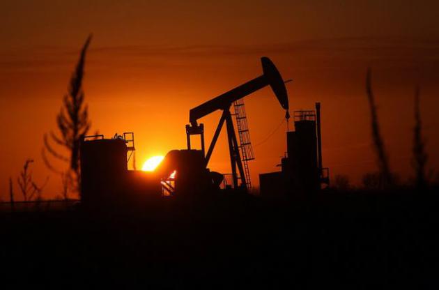
File photo credit above: "
The sun set over the Bakken Oil Formation, behind an oil well near Williston, North Dakota." Jim Gehrz - Star Tribune.