Rock Bottom
"As the days lengthen, the cold doth strengthen."
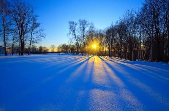
Yes it doth. Byron Gilman asks "what is the
coldest day of the year, on average?" Great question. Looking at the
last 30 years the mean temperature at MSP bottoms out at 15 F. between
January 8 and January 22. So you could make a case that the coldest days
are January 15-16.
Of course it varies from year to year, but you
may be happy to hear that temperatures rise 2 F. by the end of January.
Hints of what's to come.
No blistering, hair-curling, paint-peeling cold
is brewing, but models bring another surge of Canadian Delight south of
the border the 3rd week of January; a few subzero nights around January
16-20. Coincidence? I suspect this may be the coldest outbreak of
winter.
But first we thaw out a bit: 2 to 4 days at, or
just above, freezing next week. It may be warm enough for a rain/snow
mix next Thursday. Rain.. in mid-January. Strange. Then again, nothing
much surprises me anymore.
This may come as a shock, but I don't see any
significant snow looking out 2 weeks. 98 percent of Minnesota is now in
moderate drought or worse. We need moisture.
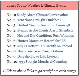
Today's blog has my video clip recap of the top
weather & climate stories of 2012. Based on my number crunching
there's no doubt in my mind 2012 will be the warmest year ever recorded
across the USA.
362 all-time record highs across the USA in 2012.
0 all-time record lows in 2012. Source: Capital Weather Gang and Weather Underground. Details below.
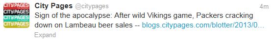
Vikes-Cast. Heading to Green Bay for Saturday's
game? The weather will be pretty tolerable, at least by Green Bay
standards: expect game-time temperatures in the low 20s under a partly
cloudy sky, a wind chill dipping into the low teens. Could be worse. A
detailed forecast for Green Bay from Ham Weather is
here.
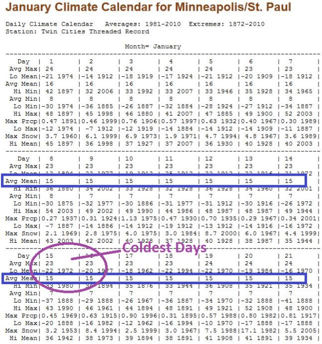
Coldest Day of Winter? I seem to get this question
every year. It's probably human nature to want to know when we reach
rock bottom, and when we can look forward to temperatures trending
upward again. The chart above show average and mean temperatures for the
month of January. The mean temperature bottoms out at 15 F. from
January 8 to 22. The midpoint of the mean is January 15-16, so you could
make a case that, statistically, these are the coldest days of winter,
on average. Of course you can prove anything with statistics. But this
tracks with conventional wisdom that, most winters, the coldest spell of
weather arrives the second or third week of January, coming about 3-4
weeks after the Winter Solstice. And cheer up, the mean temperature
rises 2 whole degrees between January 22 and 31! Calendar info courtesy
of the
Minnesota Climatology Working Group.
Risk Of A Fleeting January Thaw. The mercury may
nudge 30 (above!) today, then cool down into the low and mid 20s over
the weekend, close to normal for early January. Pacific air arrives next
week, highs near freezing from Monday into Friday. Precipitation next
Thursday and Friday may fall as a mix of rain and wet snow. A slushy
accumulation can't be ruled out, but this looks like more of a Marchlike
slush-event, possibly starting out as a little glaze ice (freezing
rain). ECMWF high temperature forecasts above are in Celsius.
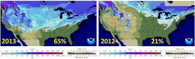
What A Difference A Year Makes. Here's one reason why I don't expect this winter to be nearly as mild as last winter. According to
NOAA data
snow is currently covering 65% of the lower 48 states of the USA; that
compares with 21% of the USA on January 3, 2012. Snow on the ground
keeps air temperatures 10-20 F. colder than they would be otherwise
(with bare ground), and this acts as a break on temperatures to some
degree. Granted, there isn't that much snow on the ground across the
Upper Midwest, in fact I expect snowcover amounts to drop by roughly
50% during next week's thaw.
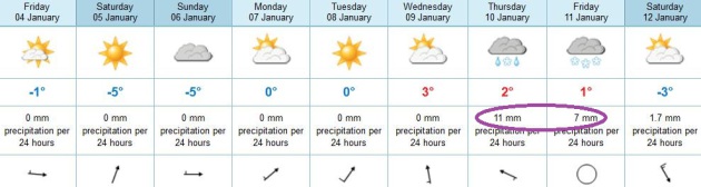
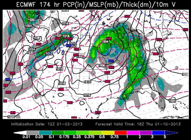
Late Next Week: Slop Storm? It's way too early to
launch into specifics, but a southern storm will push a shield of
precipitation into the Upper Midwest Thursday and Friday. To get (all)
snow temperatures in the lowest mile of the atmosphere will have to be
below 32 F. Right now that looks unlikely - models hinting at enough
warm air aloft for rain, or a rain-snow mix. Midday Thursday (January
10) guidance from ECMWF courtesy of WSI.
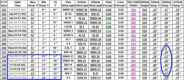
A Real Cold Front? GFS model data continues to hint
at what may be the coldest air of the winter season shaping up for the
third week of January, maybe 3-4 days with highs near zero and lows
dipping well below zero. Anytime 850 mb temperatures fall to -25 F we're
in for a bitter spell. I think we'll quickly recover by the last week
of January, but don't write off a battery-draining arctic frontal
passage just yet.
2012 USA Climate Recap. I prepared a 2:30 overview for
WeatherNation TV, our new, national weather channel. I could have spent 30 minutes recapping the extreme, bizarre year of 2012. This
YouTube clip
touches on some of the highlights, including record warmth, no real
winter, flowers blooming in March (in Minnesota!), a 1 in 500 year flood
for Duluth, the most severe derecho on record, extreme drought and
record Arctic ice loss.
2012's Surreal Record Warmth In The USA.
Meteorologist Jason Samenow has a great recap of last year, what will
almost certainly be the warmest year in recorded U.S. history, at the
Washington Post's
Capital Weather Gang; here's an excerpt: "
We
await the inevitable “official” announcement from NOAA that 2012 was
the warmest year on record in the Lower 48, by a huge margin. Recall,
in mid-December Climate Central calculated
there was 99.99999999 percent chance this feat would be achieved. In
the mean time, it’s amazing to watch related records stream in at
national, regional and local scales. Perhaps the most jaw-dropping
record I’ve encountered was posted by wunderground historian Christopher Burton: there were 362 all-time record highs logged in the U.S. in 2012 but ZERO all-time record lows.
That is an incredible disparity which - to me- seems like it would be
impossible to accomplish without a marked human influence on climate
BOTH from urbanization around weather stations and elevated greenhouse
gas concentrations..."
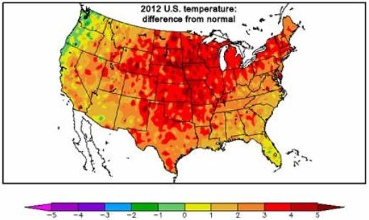
Graphic credit above: "
2012
temperatures in the U.S. compared to normal. The only large region
where temperatures were slightly cooler than normal was the Pacific
Northwest. (High Plains Regional Climate Center)."
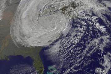
2012: A Year Of Weather Extremes. Here's an excerpt of an excellent recap of last year's jaw-dropping weather from
ouramazingplanet.com: "
From
unprecedented drought to killer cold, 2012 was a year of weather
extremes. In 2012, the United States suffered 11 weather-related events
that cost $1 billion apiece, according to a preliminary list released
Thursday (Dec. 20) by the National Oceanic and Atmospheric
Administration (NOAA). Economic losses for Hurricane Sandy and the
yearlong drought are still being calculated, but NOAA estimates 2012
will surpass 2011 in terms of aggregate costs for disasters (exceeding
$60 billion). Severe weather disasters hit beyond the United States,
too, as super typhoons slammed into Asia and a cold snap froze Europe's
rivers. Globally, countries battled heat waves and droughts..." (image above: NASA GOES Project).
Sandy Tops List Of 2012 Extreme Weather And Climate Events. The meteorologists and climate scientists at
Climate Central have a terrific overview of a wild 2012; here's an excerpt: "...
The
statistics are staggering: The first half of the year was so warm that
by early August, the U.S. had already exceeded the number of
record-high temperatures set or tied during all of 2011. July 2012 was
the hottest month on record in the U.S., as a desiccating drought
enveloped the majority of the lower 48 states, stretching its misery
from California to Delaware. The drought has been the most extensive
this country has seen since the 1930s. Ranchers were forced to sell off
their herds as their fields turned to dust and the price of feed rose
steeply; the Mississippi River neared a record-low level, threatening
to curtail commerce; and drought-fueled wildfires consumed tens of
thousands of acres across the West and threatened a large population
center in Colorado Springs...."
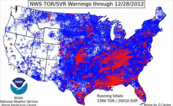
2012 Severe Storm And Tornado Warnings. Here is an interesting
YouTube animation,
showing all severe storm warnings (blue) and tornado warnings (red)
last year. Notice the concentration of tornadoes east of what is
traditional "Tornado Alley", due to drought conditions and excessive
heat much of the summer. There were far more tornadoes from Kentucky
southward to Alabama - a trend we've seen in recent years. Animation
courtesy of Greg Carbin at NOAA SPC.
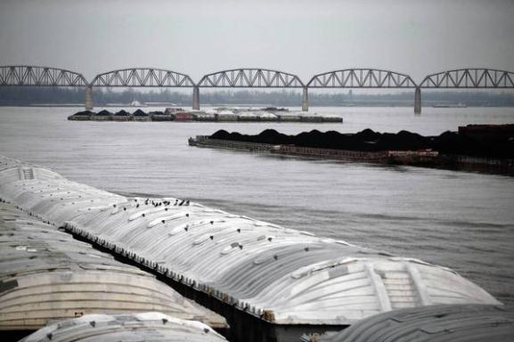
Barge Traffic Stalls Along Drought-Parched Mississippi River.
We may be a few days away from the closing of the Mississippi River to
barge traffic due to lingering drought and record-low water levels on
the (once) Mighty Mississippi. By some calculations over 8 feet of snow
would be required to alleviate drought conditions over the Central
Plains, water which would eventually help to raise water levels. Here's
an excerpt of a Chicago Tribune story, via
The Los Angeles Times: "
CAPE
GIRARDEAU, Mo. — Tim Cox was supposed to be steering an 800-foot
string of barges through the twists and turns of the Mississippi River
last week, moving tons of grain and coal toward the Gulf of Mexico.
Instead, his towboat and about half a dozen others spent nearly 15
hours stationary in the drought-parched river, about 115 miles south of
St. Louis. The boats had to stop while crews dredged downstream in a
desperate attempt to keep the shipping channel open as the river
approaches historically low levels. Cox, second in command on the
towboat LJ Sullivan, sat in the captain's chair high above his barges,
looking out the wheelhouse windows in disbelief at sandbars and stone
dikes that are usually deep underwater..."
Photo credit above: "
Water levels are low along the entire
Mississippi River, but the Army Corps of Engineers says the worst
stretch is from St. Louis to Cairo, Ill., where the Ohio River flows
in. Above, barge traffic on the Ohio River at Cairo."
(E. Jason Wambsgans / Chicago Tribune / December 20, 2012)
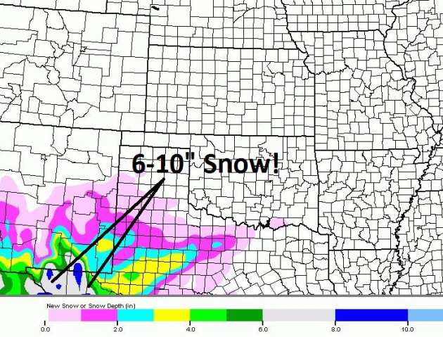
Ski Mexico! For months I've been telling you how
storms are (once again) detouring well south of Minnesota. Who is seeing
snow? According to the NAM model (courtesy of Weathercaster) as much as
6-10" snow is expected west of El Paso, Texas. Good grief.
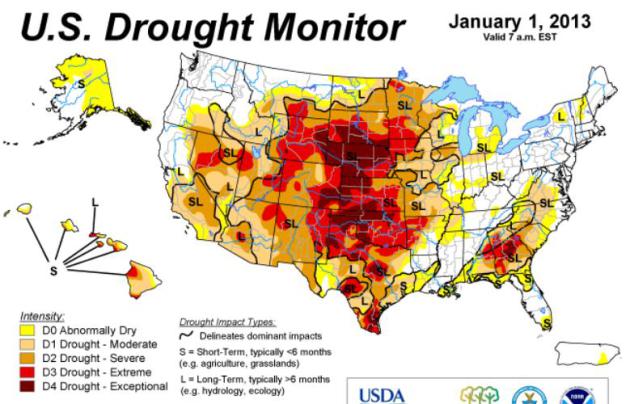
Nagging Drought. It's being called the worst U.S.
drought since 1956; exceptional drought conditions being reported from
South Dakota and Nebraksa southward to Texas. The latest U.S. Drought
Monitor is
here.
"Extreme Rain": UK Warned Over Flood Risk. Whilte much of the USA suffers through debilitating drought - 2012 was the wettest year ever recorded for the United Kingdom.
Sky News has a video report on the parade of storms; here's an excerpt of their story: "
The
UK is suffering more "extreme rainfall", which could have a serious
impact on flooding problems, the Met Office has warned. The torrential
downpours that have hit the UK this year are of a similar magnitude to
those being experienced by China and India, according to the
scientists. They have called for more research to be done to help
protect the country from flooding in the future as these "extreme"
weather events threaten to become more frequent. The disclosure has
sparked warnings from environmentalists that it is further evidence of
climate change in action..."
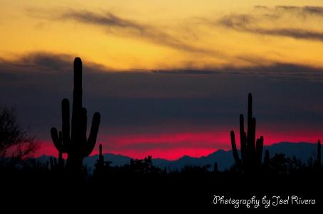
"Chilly" In Phoenix. The forecast calls for Phoenix
calls for lows in the upper 30s, highs in the upper 50s to mid 60s. I
could deal with that. Thanks to
Joel Rivera and WeatherNation TV for sharing this photo.
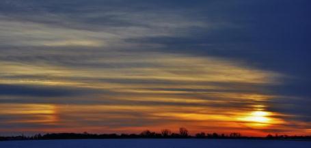
Parhelia.
Donna Wick Paul
snapped this photo in Piqua, Ohio yesterday, capturing a "sun dog" or
mock sun, triggered by sunlight being refracted (bent) by hexagonal ice
crystals.
A Good Excuse To Check Out Kickstarter.
Crowdsourcing is becoming an increasingly popular way of raising money
for projects, products and new services that resonate with people. O.K.
I'm a little biased, but I'm a fan of up and coming Twin Cities
rock/blues/funk band "
The Lost Wheels", and they're trying to raise a little money to create a new CD for their growing legion of
fans around the state. Even if you don't want to be a part of this groundswell, check out their
Kickstarter video - it'll give you a much-needed chuckle or two.
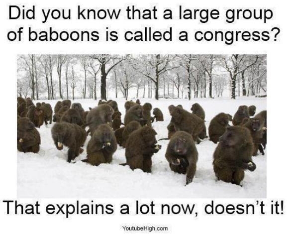
I Did Not Know That. Thanks to Youtubehigh.com for clearing this up for us. Suddenly it all makes sense...
Climate Stories...
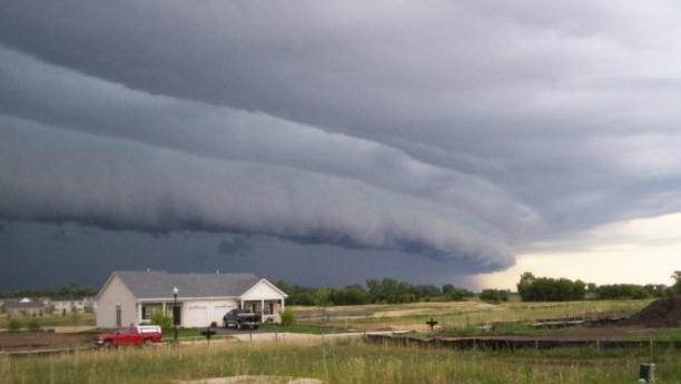
Another Record-Breaking Year For Climate Change. The Wichita Eagle has another look back at 2012, a year that won't soon be forgotten for a string of climate calamities; here's an excerpt: "
It’s
virtually certain that 2012 was the warmest year on record for the
continental United States. When scientists affirm these results,
they’ll no doubt make headlines. But we should put that record in
perspective. North America covers just 2 percent of the Earth’s
surface. Globally, we’re set to have another very hot year, likely in
the top 10, according to the World Meteorological Organization. Looking
further back, the past 35 years have all exceeded the 20th-century
average global temperature. That’s a generational shift. Half the U.S.
population is 35 or younger, so half of all Americans have never lived
through an “average” year..." (wall cloud photo above courtesy of Brittney Misialek, from NOAA SPC).
In Farewell Speech, House Republican Lists Climate Change As A Top Priority. Here's an excerpt from
Think Progress: "
During
his farewell speech Tuesday, outgoing House Rules Committee Chairman
David Dreier (R-CA) listed climate change as a top problem facing the
country — a rare moment when a Republican leader in office openly
acknowledged the need for climate action. Taking to the House floor,
Dreier said climate change “is a fact of life” that must be confronted, and said it should be an imperative on par with the economy and gun control for his party..."