Blessed and Baffled
Weather in Heaven? Yes, but the clouds are pink
and high-flying "glowing orbs" (angels?) show up on Doppler. "Proof of
Heaven" documents the extraordinary story of a neurosurgeon who was
brain-dead for a week - a former agnostic who glimpsed a world for which
science has no answers. Skeptical? Read the book, and then let's talk.
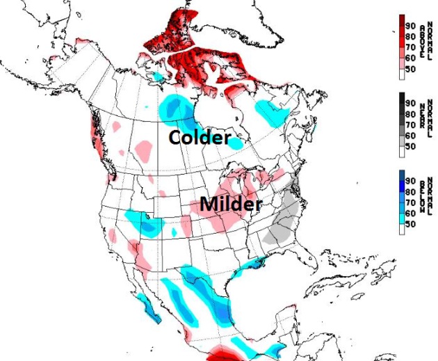
Winters are trending warmer over time. Today's
blog shows trends in Heating Degree Days & compelling evidence that
MSP is already in USDA Climate Zone 5. The coldest nighttime lows of
winter in the Twin Cities are much warmer (now) than they were 20-30
years ago. The data is the data. Facts on the ground.
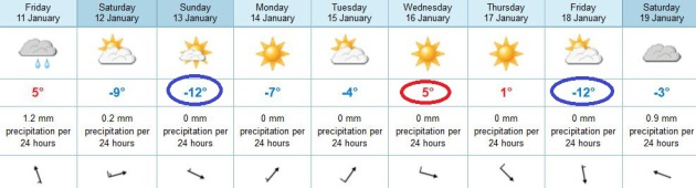
We should see an average of 30 subzero nights
every winter. Last winter? 3. This winter we may see 3-6 nights below
zero; a few glancing blows of Arctic air the next 2 weeks. It'll be a
pale imitation of the brutal blasts we endured back in the 1970s and
early 1980s.
Ice is possible up north today but the metro
area sees light rain and drizzle; highs top 40 under a March-like sky.
Enjoy the warm front, because a cold wind chill returns tomorrow; Sunday
will be nearly 30 degrees colder than today.
We thaw out briefly the middle of next week. A
subzero low is possible late next week, again around January 21 - the
coldest spell of winter?
A winter that should (once again) track milder than average.
Ask Paul. Weather-related Q&A:
"Paul, the weather guy,
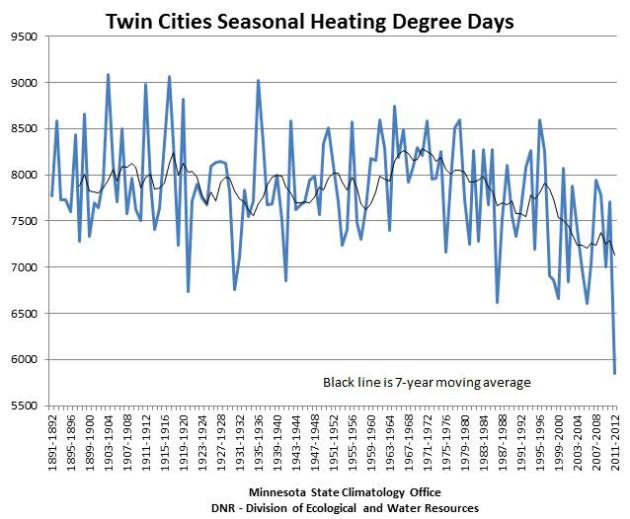
I have seen in the news paper the degree heating and cooling days on a yearly basis. Has anyone done a ten year moving average of the degree heating and cooling days? This is a very common thing in the stock market to see how a stock is behaving over a particular period. It would seem to provide a way to see long term changes in our climate.
Thanks."
I asked Pete Boulay, at the Minnesota Climatology Working Group, for his perspective and here is an excerpt of what he wrote:
"We usually prefer a 7-year moving average
to look at recent trends. Here is a graph of seasonal HDD (heating
degree data) values for the Twin Cities from 1891-92 to 2011-12 (the
last time we have a complete season). Yes, I believe we have saved a
lot of money (heating our homes and businesses) in recent winters."
Tracking The Trends. The graph above, from the
Minnesota State Climatology Office and the MN DNR, shows heating degree
days since 1891-92. To calculate the heating degree data for any given
data determine the average temperature (high and low) and subtract
from 65. So an average of 10 degrees F. would equate to 55 heating
degree days, and then add them up over time. The black solid line above
shows a smoothed trend line, showing a drop in HDD since the early 70s
as Minnesota winters have warmed over time. It's hardly breaking news:
our winters are trending milder over time.
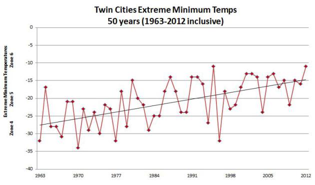
Coldest Nighttime Lows at MSP Since 1963. Here is
another interesting way to look at the data, a graph showing the
coldest nighttime low (for every winter) going back nearly 60 years.
The black line is the trend line over time, showing the same gradual
warming trend. It's not getting as cold, for as long, as it did back in
the 60s and 70s. Again, if you've been paying attention, this hardly
comes as breaking news. Thanks to Jack Falker, an accomplished
rose grower
from Edina, for passing this along. Jack has compelling evidence that
the Twin Cities metro is already in USDA Zone #5 (warming from Zone #4
in recent years). He suspects we may be close to entering Climate Zone
#6 before long. Jack Falker writes:
Twin Cities in USDA Zone 5
"With our very warm 2012, and much warmer than
normal winter-to-date in 2013, it becomes more and more obvious to me as
a rose gardener that the Twin Cities have moved firmly into USDA Zone
5, where the extreme minimum temperature (EMT) is expected to be between
-10 and -20 degrees, rather than our previous EMT expectation in Zone 4
of -20 to -30 degrees.
Notice how the upward slope of the 50 year
graph I developed using Minnesota Climatology (NOAA) statistics, takes
us right out of USDA Zone 4 into Zone 5. And following that upward slope, it looks like we could be headed higher yet toward Zone 6 (EMT -0 to -10). Last fall and winter-to-date in 2013 certainly bear that out. Our
EMT thus far in January was -5 on January 1st and, looking at the
models in your weather blog on Thursday, January 10th, it looks like we
might not get much colder than that, which would be our first zone 6
winter, with the highest EMT on my 50 year graph and perhaps in history."
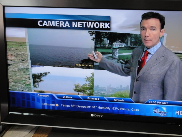
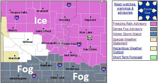 Freezing Rain Advisory.
A few icy patches are possible early - especially northern suburbs. I
don't expect major problems in the immediate Twin Cities with ice
(freezing rain) later today, but if your travels take you north/west
of Mille Lacs, toward Brainerd, Crosby, Aitkin or Duluth, watch the
bridges and secondary roads. All those soggy roads and puddles will
turn to ice tonight as temperatures fall (hard). Details from the local
NWS:
URGENT - WINTER WEATHER MESSAGE
NATIONAL WEATHER SERVICE TWIN CITIES/CHANHASSEN MN
748 PM CST THU JAN 10 2013

...LIGHT FREEZING RAIN FOR PORTIONS OF CENTRAL MINNESOTA AND WEST
CENTRAL WISCONSIN TONIGHT...

.LIGHT FREEZING RAIN WILL CONTINUE TONIGHT ACROSS CENTRAL
MINNESOTA...ESPECIALLY ALONG AND NORTH OF A LINE FROM MORRIS TO
MINNEAPOLIS TO RED WING...AND IN WEST CENTRAL WISCONSIN. THE LIGHT
FREEZING RAIN WILL CONTINUE INTERMITTENTLY THROUGH THE NIGHT...AND
LINGER INTO FRIDAY MORNING ACROSS THE NORTH. TEMPERATURES WILL
WARM INTO THE MIDDLE 30S BY MIDDAY FRIDAY.

...FREEZING RAIN ADVISORY IN EFFECT UNTIL 3 AM CST FRIDAY...

THE NATIONAL WEATHER SERVICE IN TWIN CITIES/CHANHASSEN HAS ISSUED
A FREEZING RAIN ADVISORY...WHICH IS IN EFFECT UNTIL 3 AM CST
FRIDAY.

* TIMING...LIGHT FREEZING RAIN CONTINUING TONIGHT...AND LAST
  THROUGH EARLY FRIDAY MORNING.

* ICE ACCUMULATIONS...UP TO A TENTH OF AN INCH.

* OTHER IMPACTS...UNTREATED ROADS AND WALKWAYS WILL BECOME
  SLIPPERY. ICE WILL ACCUMULATE ON VEHICLES LEFT OUTDOORS.

PRECAUTIONARY/PREPAREDNESS ACTIONS...

A FREEZING RAIN ADVISORY MEANS THAT PERIODS OF FREEZING RAIN OR
FREEZING DRIZZLE WILL CAUSE TRAVEL DIFFICULTIES. BE PREPARED FOR
SLIPPERY ROADS. SLOW DOWN AND USE CAUTION WHILE DRIVING.
Global Weather Whiplash. Here's the latest installment of my (daily) climate headlines, available at
YouTube: "
Unprecedented
Heat in Australia, Snow in the Middle East. In today's climate
segment, Meteorologist Paul Douglas looks at some of the weather
extremes around the world."
 Big Swings
.
The (usually more reliable) European model hints at highs near 40
today, then falling thru the 20s and teens tomorrow, with highs close to
10-14 F. by Sunday. We thaw out (briefly) by the middle of next week
before another punch of cold air by Friday of next week. Cold enough,
but Old Man Winter is still pulling his punch. ECMWF forecast highs
above in Celsius.
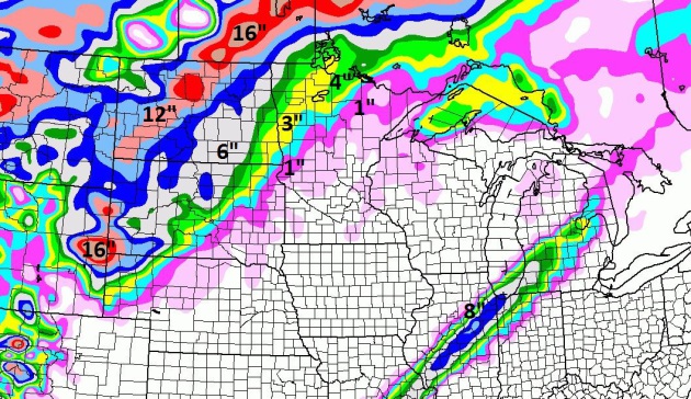
84 Hour Snowfall Forecast. Here's the latest NAM
outlook, showing a couple inches from near Fargo/Moorhead into the Red
River Valley, a major snowfall for the Dakotas, Wyoming and Montana.
Cold, But Not "Arctic". The GFS keeps flip-flopping,
like a nutty D.C. politician. The latest run shows a couple "waves" of
cold air pushing south of the border, starting this weekend and early
next week, another surge late next week, maybe 1-3 subzero nights in the
metro area. Long (long) rainge guidance shows 30s returning by the end
of January.
NAEFS Extended Outlook. Experimental long-range
guidance from NOAA's NAEFS model keeps the worst of the cold wave near
Hudson Bay between January 18-24. Confidence level: low. Bitter air
will be oozing just north of Minnesota - it wouldn't take much to pull
the core of this cold wave into Minnesota, but right now it appears the
worst of the negative numbers will stay just north of the border.
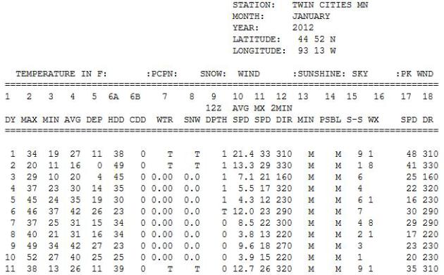
"March-uary": January 2012. Remember last year at
this time? Freakishly warm, in fact a year ago today it was 52 F. in the
Twin Cities. We saw 9 days of 40-degree or warmer temperatures late
January, setting the stage for the warmest year in Minnesota history.
Check out the January 2012 data from the
Minnesota Climatology Working Group.
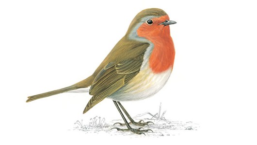
From A Star Tribune Reader:
Hi Paul,
I live in Inver Grove Heights and Robins are here already. This is the earliest I've seen them that I can recall. What is your take on this?
Best regards,
Jerry Wussow
Jerry
- those are brave robins, that's all I can say. By Saturday they will
probably regret their decision to stay (or migrate) to Inver Grove
Heights. I suspect it's a fluke - I can't say I see any sign (yet) of an
early spring, nothing like what we experienced last "winter". Thanks
for passing this along.
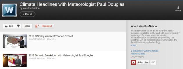
Climate Headlines. Here's
one YouTube link
that has all the 2:30 climate headlines I'm creating for
WeatherNation TV and our other media partners - a chronological list
of segments highlighting some of the biggest weather and climate
stories that made me do a double-take.
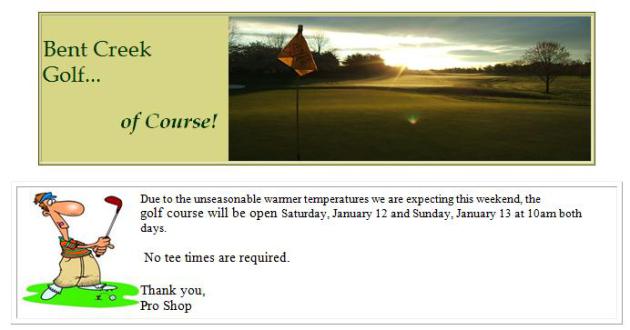
January Golf? My father lives in Lancaster county,
Pennsylvania, about 80-90 minutes west of Philadelphia. With
unseasonable warmth in the forecast the local golf course has decided to
open up next weekend. No tee times are required. Sounds like a good
plan to me.
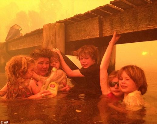
Grandparents Save Five Kids From "Tornadoes Of Fire" in Australia. I've never ever seen anything quite like this - an excerpt of a harrowing, life and death story at
Get Energy Smart Now! "Breathtaking images: "
Grandfather
Tim Holmes took these harrowing photos of his five grandkids escaping
the wildfires because he feared their parents ‘would never see them
again.’.....Mr Holmes told how he sent his wife, their grandchildren and
pet dog Polly to the nearby sea jetty when he saw smoke from the
looming wildfire rise from a nearby ridge.’For the next two-and-a-half
hours, we huddled under the jetty as the fire intensified and produced a
plume of smoke, ash and debris that left us with very little oxygen..."
Photo credit above: Associated Press. "
Tammy Holmes
shelters her grandchildren Charlotte Walker, 2, Esther Walker, 4, Liam
Walker, 9, Matilda, 11, and Caleb Walker, 6, under a jetty as a
wildfire rages nearby in Dunalley, Australia, Jan. 4, 2013. This photo
was taken by Tammy Holme’s husband Tim Holmes." Photo by Tim Holmes, via:
Time
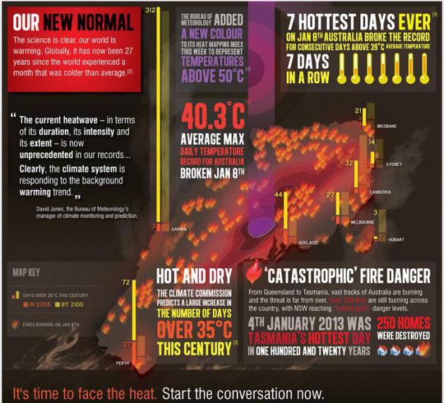
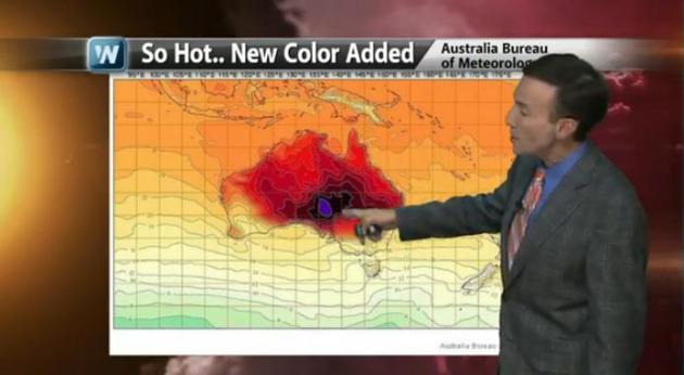
Australia Record Heat Infographic.
Click here to see this full screen, courtesy of getup.org.au.
Australia Braces For More Blistering Heat After Record Bursting Spell. Meteorologist Jason Samenow has more details at The Washington Post's always-informative
Capital Weather Gang; here's an excerpt: "
Four
of Australia’s hottest 10 days on record have occurred this young
calendar year and another punishing round of heat is on the way. On
Monday, Australia’s average high temperature reached a scorching 40.33 C
or 104.5 F, the hottest day on record. David Jones, manager of climate
monitoring for Australia’s Bureau of Meteorology told the Associated
Press that the extent, duration and intensity of this summer’s heat
wave is “arguably the most significant in Australia’s history.”
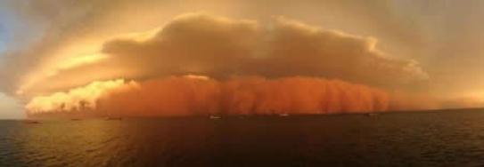
Photo credit above: "
A
dust storm associated with a collapsing thunderstorm or “haboob”
photographed in western Australia. Hot weather has set records and
contributed to both wildfires and dust storms in the land down under." ( Levi Cooper / Perth Weather Live )
Too Hot: Australia's Big Heat-Breaking Records. Here's an excerpt of a story on the historic levels of heat gripping Australia from New Zealand's
Hot Topic: "...
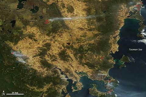
NASA’s Earth Observatory provides this overview
of the fires in Tasmania over the weekend that caused chaos and
destruction in the normally cool state — Hobart hit an all time high
temperature of 41.8ºC, a full degree above its previous record. Fire
danger in parts of New South Wales has been classified as catastrophic,
and this NASA Worldview image for Jan 8th appears to show smoke from fires in southern NSW streaming out to the east and over the sea towards New Zealand..."
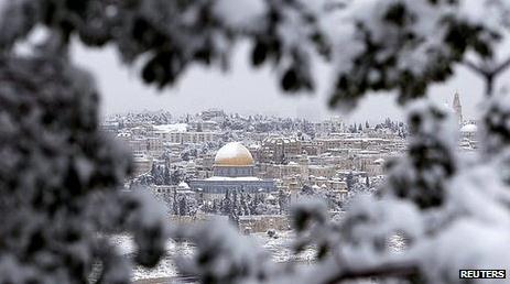
Deadly Storms Blanket Parts of Mideast In Snow. The
BBC reports; here's an excerpt: "
The
worst storms to hit the Middle East in a decade have claimed several
lives and left large parts of Israel and Jordan blanketed in snow.
Across the region, many schools are shut and thousands of homes are
without power. Heavy snow in Jerusalem on Thursday brought transport to a
standstill. The freezing conditions have brought misery for thousands
of Syrians living in refugee camps in northern Jordan, Turkey and
Lebanon. Two weather-related deaths were reported in Lebanon including
that of a baby swept away in a flash flood..." (Photo credit: Reuters).
9 Worst Things About Being Over 50? Yes, I can
relate. In my head I'm still 24. My body, however, disagrees (loudly)
some mornings. Here's an excerpt of an article at
PBS's Next Avenue that caught my eye: "
On
the upside, growing older means you’ve accumulated a good deal of
experience and wisdom as well as an abundance of instructive and
entertaining stories. But there’s a sharp downside, too. Take action
now to make sure that the challenges below don’t end up defining your
second and third acts.
1. You’re closer to the end. Planning for the end of
life — your own and that of your elder loved ones — is more urgent than
ever before. Not doing so may mean enduring costly medical measures
that prolong life without sustaining its quality and burdening others
with agonizing decisions based on guesswork.
Solution: Have end-of-life conversations with
family members soon, fill out the legal documents that make your
medical wishes and estate management affairs clear and analyze long-term
care insurance options...."
Photo credit: Digital Vision/Thinkstock , nextavenue.org.
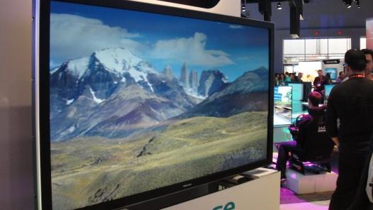
3-D HDTV - Without The Glasses? This article at
gizmag.com caught my eye; here's an excerpt: "
In addition to a 110" Ultra-HD LED TV, Hisense also revealed its latest take on glasses-free 3D
technology at CES with the GF60XT980 television concept. The new
60-inch TV uses an Ultra High Definition (UHD) panel to provide a clear,
3D picture from almost any angle, so multiple viewers can enjoy the
3D effect without needing multiple pairs of glasses..."
Old Fashioned "Windshield Wiper". Not sure where this is from, but I'm feeling better about the wipers on my car.
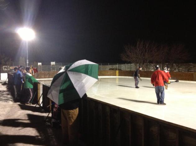
January Broomball - In The Rain? Thanks to
WeatherNation TV meteorologist Todd Nelson, who shared this photo last
night. Todd can't remember a time he was broomballing in the rain. Odd.
Climate Stories...
"There are two ways to be fooled. One is to believe what isn't true; the other is to refuse to believe what is true".
- Soren Kierkegaard (1813-1855)
Climate Change In The Age Of Truthiness. Here's a clip of an article at
The Energy Collective
that resonated with me. Lately it seems truth (at least about climate
change and the scientific method) has entered a slippery slope: "
Does reality shape our beliefs, or do our beliefs shape "reality"? A fascinating paper
by "Did the Arctic Ice Recover? Demographics of True and False
Climate Facts" by Lawrence Hamilton examined this question using
polling data on people's beliefs about climate change and their
knowledge of several key climate facts, including that the Arctic sea
ice is decreasing. Hamilton finds that existing beliefs about climate
change influence acceptance of the facts, or, better put, which
"facts" one chooses to accept. In the study, 80% of people who believe
climate change is happening and is caused by human activity know that
sea ice is declining. Of those who do not believe climate change is
happening or who do not think it is caused by human activity, however,
only 60% think the Arctic sea ice has been in decline..."
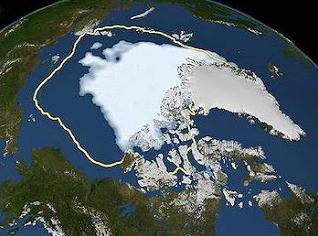
Graphic credit above: "
Record low Arctic sea ice, September 16, 2012" (
NASA/Goddard Scientific Visualization Studio)
Has Global Warming Ground To A Halt? The short
answer is no, but there are a lot of persistent denialists out there
who would have you believe otherwise. Details in this excerpt from
NewScientist: "
The UK's Met Office has downgraded its forecast for warming at the Earth's surface over the next five years. Headlines
this week announced that global warming is "at a standstill". Climate
sceptics crowed. But the Met Office said the outlook for later in the
century remains unchanged. New Scientist looks at the facts.
Has global warming stopped, or hasn't it?
Atmospheric warming has certainly slowed greatly in the past decade.
The Met Office says this appears to be due to natural cycles that are
counteracting the warming effect of greenhouse gases. After
incorporating new analysis of natural cycles into its latest model of
atmospheric and ocean circulation, it has concluded
that we are in for a few more years of little change. Having
calculated annual global temperatures for the next five years, its
best guess is that they will be, on average, 0.43 °C higher than the
average for 1970 to 2000. That's down from its previous prediction of a
0.54 °C rise. If the new prediction proves right, then 2017 will
barely be warmer than most years in the past decade..."
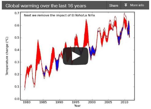
16 (More) Years Of Global Warming. One of the
denialist memes going around now is "there hasn't been any warming since
1998." Really? The last 9 consecutive 12 month periods over the USA
"conus" have been the warmest ever observed. We've gone 28 years in a
row with global temperatures consistently warmer than the 20th century
average. If you strip away volcanic and solar activity, as well as
biases brought on by El Nino and El Nina, there is no scientific
evidence that the rate of global warming has slowed...or peaked...or
dropped. None.
Skeptical Science takes a look at the latest scientific conspiracy theory: "
Human greenhouse gas emissions have continued to warm the planet over the past 16 years. However, a persistent myth has emerged in the mainstream media challenging this. Denial of this fact may have been the favorite climate contrarian myth of 2012, first invented by David Rose at The Mail on Sunday with an assist from Georgia Tech's Judith Curry, both of whom later doubled-down on the myth after we debunkedit. Despite these repeated debunkings, the myth spread throughout the media in various opinioneditorials and stunts throughout 2012. The latest incarnations include this article at the Daily Mail, and a misleadingly headlined piece
at the Telegraph. As a simple illustration of where the myth goes
wrong, the following video clarifies how the interplay of natural and
human factors have affected the short-term temperature trends, and
demonstrates that underneath the short-term noise, the long-term
human-caused global warming trend remains as strong as ever..."
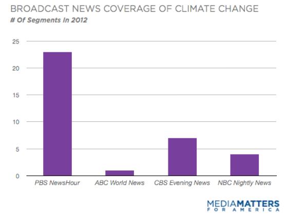
What Nightly News Shows Can Learn From PBS's Climate Coverage. Here's an excerpt of a report from
Media Matters: "
A Media Matters analysis found that the nightly news programs on ABC, CBS and NBC largely ignored climate change in 2012, despite record-breaking temperatures and a series of extremeweatherevents
in the U.S. By contrast, PBS NewsHour devoted almost twice as many
segments to climate change as the other networks combined. When the
National Climatic Data Center announced Tuesday that 2012 was the hottest year in recorded history for the contiguous U.S., broadcast networks admirably devotedsegmentsconnecting the announcement to climate change. But for most of the year they turned a blind eye to climate change, even while reporting on its consequences. Together,
the nightly news programs on ABC, CBS and NBC devoted only 12
segments to climate change in 2012. PBS' coverage stood out, with its
nightly news program dedicating 23 segments to the issue..."
NASA Chases Climate Change Clues Into The Stratosphere. Here's a clip from a recent article from
NASA: "
Starting
this month, NASA will send a remotely piloted research aircraft as
high as 65,000 feet over the tropical Pacific Ocean to probe
unexplored regions of the upper atmosphere for answers to how a
warming climate is changing Earth. The first flights of the Airborne
Tropical Tropopause Experiment (ATTREX), a multi-year airborne
science campaign with a heavily instrumented Global Hawk aircraft,
will take off from and be operated by NASA's Dryden Flight Research
Center at Edwards Air Force Base in California. The Global Hawk is
able to make 30-hour flights. Water vapor and ozone in the
stratosphere can have a large impact on Earth's climate. The
processes that drive the rise and fall of these compounds, especially
water vapor, are not well understood. This limits scientists'
ability to predict how these changes will influence global climate in
the future. ATTREX will study moisture and chemical composition in
the upper regions of the troposphere, the lowest layer of Earth's
atmosphere. The tropopause layer between the troposphere and
stratosphere, 8 miles to 11 miles above Earth's surface, is the point
where water vapor, ozone and other gases enter the stratosphere...."
The Market And Mother Nature. Here's the intro to an Op-Ed in the
New York Times from St. Louis Park's Thomas Friedman: "
Whenever
I hear the word “cliff,” I am reminded of something that President
Obama’s science adviser, John Holdren, used to say about how we need
to respond to climate change because no one can predict when it might
take a disruptive, nonlinear turn. “We are driving toward a cliff in
a fog,” said Holdren about the climate, and that’s always a good time
“to start tapping on the brakes.” Indeed, when you think about how
much financial debt we’ve built up in the market and how much carbon
debt we’ve built up in the atmosphere, the wisest thing we could do
as a country today is to start tapping on the brakes by both emitting
less carbon to bend the emissions curve down and racking up less
debt to bend our debt-to-G.D.P. curve down. Unfortunately, we are
still doing neither..." (satellite image above: NASA).
Billion Dollar Weather/Climate Disasters In 2012. Here is a list of the most extreme weather and climate events in 2012, courtesy of
NOAA NCDC.