Going Over The Temperature Cliff
Two words come to mind. Character-building.
Minnesotans get a rare chance to strut our cold-weather-stuff. This will
probably the coldest air of winter - but a pale imitation of the Arctic
fronts that were the stuff of legend 30-40 years ago. Probably not
record-setting, but cold enough for most.
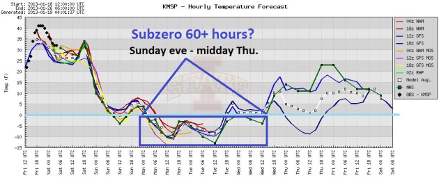
Air temperatures hover below zero from Sunday
evening thru midday Tuesday; roughly 36 hours of a mild, burning
sensation when you sneak out of the house. Take a deep breath Monday and
you'll feel ice crystals up your nose; an odd sensation. Lows dip to
-10 F. in the metro, a Monday wind chill as low as -20 F.
Monday should be the first subzero high in 4
years (1,466 days to be exact). According to Mark Seeley that's the
longest stretch of above-zero daytime highs since records were started
in 1873.
Sneak out this morning; a thaw into midday. 40
mph. winds kick in this afternoon; by tonight there will be no doubt
there's nothing between you and the North Pole but a barbed wire fence.
A coating of fluff is possible Sunday, maybe a
couple inches Thursday (more up north).
Another shot of brittle
air arrives next weekend, although not quite as cold.
We should thaw out by late January!
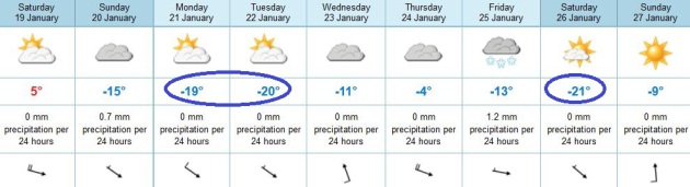
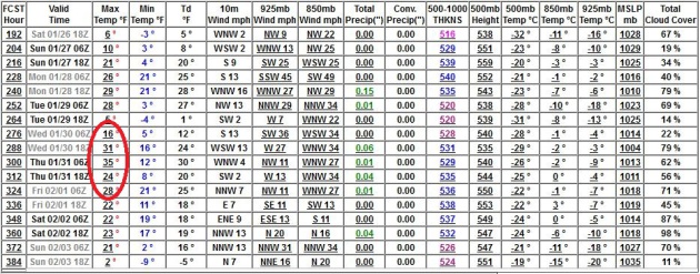
Coldest In 4 Years? During January of 2009 we
experienced 3 subzero daytime highs in the Twin Cities. This time around
we'll see one, possibly two consecutive days below zero (Monday and
possibly Tuesday). We should finally climb above zero Wednesday - 20s by
Thursday will feel like a Godsend. Graphic: Iowa State.
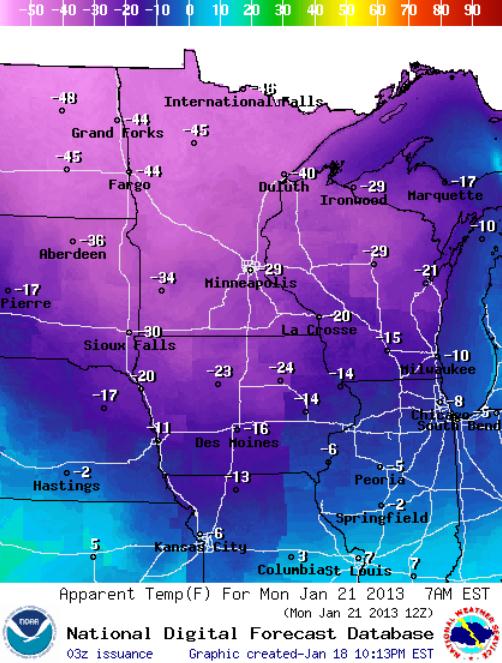
Serious Wind Chill. NOAA is predicting a wind chill
of -29 F. in the Twin Cities by 7 am Monday, as cold as -40 at Duluth
and a -44 wind chill in Fargo/Moorhead. To say the risk of frostbite and
hypothermia will be high would be an understatement. So I won't say it.
Time to dig out a few extra layers. Take the chill seriously.
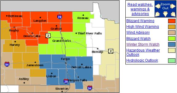
Ground Blizzard Potential. The problem won't be so
much falling snow, but sustained high winds whipping up the snow already
on the ground over the Red River Valley. A Winter Storm Watch is posted
for Detroit Lakes and Fergus Falls, Blizzard Watch in effect for Thief
River Falls, Crookston and Roseau, with Blizzard Warnings at Hallock. If
you're driving into the Red River Valley Saturday plan on near-zero
visibility with blowing snow; winds gusting to 50 mph producing
treacherous travel, and a wind chill dipping to -40 F. by Sunday
morning. Details from the
Grand Forks NWS.
Double-Header. By now you know (ad nauseum) that
Monday and Tuesday will take your breath away. Literally. After warming
up a bit later next week another cold surge arrives next weekend;
ECMWF guidance hinting that highs next Saturday, a week from today, may
hold below zero as well. Not convinced (yet). But there's little doubt
in my mind that the next 7-8 days will be the coldest of the winter.
A Reason To Go On Living. We will climb out of the
temperature cellar by the end of the month, GFS data hinting at some 30s
the last few days of the month. Hang in there.
Absence Of Below Zero F. High Temperatures. In this week's
Weathertalk Newsletter
Dr. Mark Seeley has a good summary of the streak of above zero daytime
highs here in the Twin Cities, but the warm bias is even showing up in
the city famous for (among other things) testing car batteries,
International Falls: "...
For Twin Cities residents we may be seeing a
remarkable record weather streak come to an end by Martin Luther King
Day (Monday, Jan 21st). The Twin Cities have not reported a daytime
high temperature below 0 F since January 15, 2009 (high of -6 F). By
Monday, this streak will be 1466 days long, the longest such streak in
the Twin Cities climate record back to 1873. In addition the National
Weather Service reports a remarkable absence of below 0 F minimum
temperatures for the Twin Cities in recent winters as well, with only 3
such days last winter, and 1 so far this winter. This trend, but to a
lesser extent is obvious in the recent data for International Falls as
well. There the average number of days when the high temperature
remains below 0 F is about 10 per winter. Over the past three winters
it has just been 3 days. In addition, overnight minimum temperatures
at International Falls fall below 0 F slightly 60-61 days per winter on
average. Last winter brought only 35 such days, and there have been
only 26 such days so far this winter, well below average...
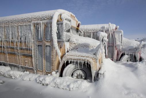
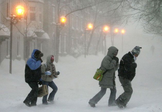
File photo above: AP. The local NWS office has more on our streak of days with daytime highs above zero
here.
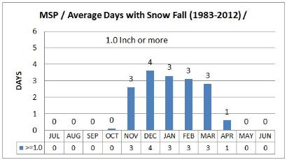
Days With One Inch Or More In The Twin Cities. So
far this winter the Twin Cities have experienced 3 days with 1" or more
of snow falling in a 24 hour period. As you can see from the graph above
the Twin Cities pick up an average of 17 days/winter season with 1" or
more of snow, on average. Oh, to be average again. Graph courtesy of the
Twin Cities National Weather Service.
Primetime Wintertime. It's a bit strange to be
getting intense cold - without the snow. If you're looking for serious
snowfall amounts fly to London, or Paris, or the south of France.
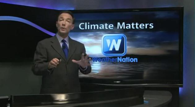
Details on the latest installment video of
Climate Matters: "
As
the Midwest prepares for an arctic blast, snow is crippling travel in
other parts of the world. Meteorologist Paul Douglas looks at some of
the global temperature extremes and winter conditions around the globe."
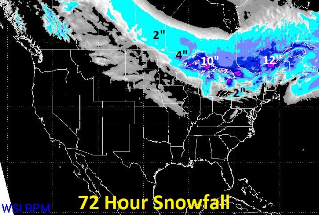
72 Hour Snowfall Prediction. Here are the results of
WSI's (remarkably good) 12km. RPM model, showing some lake effect snows
as the coldest air of winter (so far) plows south of the border. As
much as 4" may pile up over the Minnesota Arrowhead, with some 10-12"
lake effect snows over the U.P. of Michigan. Graphic: WSI.
Equation Of Time Solves Problem Of Gray Mornings. As of today sunset is
30 minutes later than it was on December 21, yet sunrise is only
3 minutes earlier. Why isn't it equal? This is a question I get often, and (sadly) there is no easy answer, but this
New York Times article does the best job I've ever seen explaining the disconnect; here's an excerpt: "...
Earth’s
tilt means that every day during the fall, the angle at which we view
the Sun changes. It appears farther south and travels a shorter arc
across the sky, affecting sunrise and sunset equally, and making the
day shorter. The changes in the solar time follow a different cycle. In
the early 1600s, Kepler
discovered that planets move faster at the part of their orbit that is
closest to the sun, the perihelion. For Earth, perihelion comes a
little after the winter solstice, so from November on, Earth is
accelerating. That increased speed means we reach the Sun’s maximum a
little earlier each day, which pushes solar noon backward against clock
time. That shift is amplified because the Sun is traveling a little
south each day, while clocks only count its east to west traverse. Add
it all together and you get sunrise and sunset times that are not
symmetrical..."
Snowfall Amounts From Recent Storm:
Beech Mountain, NC 11.2 inches
Sparta, NC 9.5 inches
Boone, NC 7.5 inches
Greensboro, NC 3.0 inches
Raleigh, NC 2.0 inches
Pearisburg, VA 9.0 inches
Blacksburg, VA 7.5 inches
Rocky Mount, VA 5.5 inches
Covington, VA 3.0 inches
Newport News, VA 2.5 inches
Ronceverte, WV 8.2 inches
Washburn, TN 5.6 inches
Greenville, TN 3.6 inches
Bishopville, MD 1.5 inches
Selbyville, DE 1.0 inch
* Thanks to Julie Gaddy at Earth Networks for
sharing these snowfall amounts. Image of Lynchburg, Virginia above
courtesy of Javan Shashaty and
Twitter.
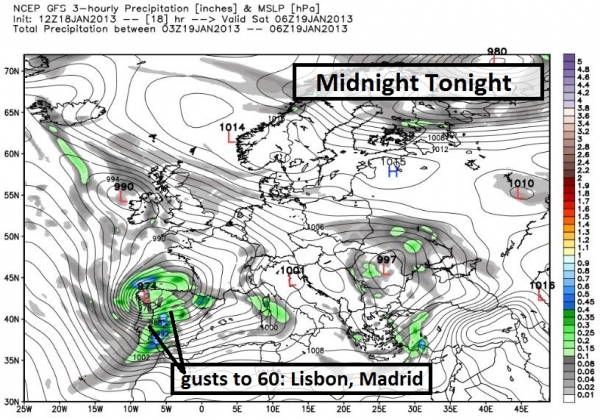
Series of Major Storms Impacting Europe. Here is an excerpt of a Friday briefing sent to our
Alerts Broadcaster clients:
* series of significant snow and wind storms on tap for Europe; 2-5"
snow expected London and Paris, French Riviera may pick up a foot of
snow by Tuesday - winds up to 60 mph for Portugal and Spain tonight and
early Saturday.
* coldest air of winter pushes into northern tier states from
Saturday PM into the middle of next week; subzero highs - wind chills
dip to -25F.
* extreme heat continues across Australia and central Africa, more 100-degree highs likely.
What You Should Know:
Family of Major Storms Impacting European Operations.
This is marginal for London and Paris, but a "plowable" snowfall of
2-5" should be enough to shovel and plow. Parts of Ireland and Wales may
pick up closer to 6-12" snow. The first in a series of storms will
blow into Portugal and Spain later today and Saturday with heavy
rain/snow and winds gusting as high as 60 mph, capable of downing trees
and power lines.
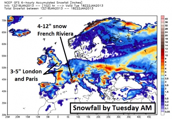
Snowfall Potential. The map above shows snow totals
by Tuesday morning, anywhere from 2-5" for metro London and Paris, but
closer to 8-12" for Limerick, Ireland, as much as 12-16" for northern
Spain and 6-12" for the French Riviera, from Nice and Monaco to Genoa,
where some roads may become impassable from this weekend into early
next week.
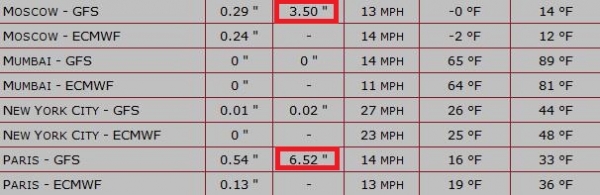
Predicted Snowfall Amounts. Alerts Broadcaster
models are predicting as much as 6-7" snow for Paris, 3-4" in Moscow,
3-4" in Frankfurt and Geneva, and 2-3" for central London.
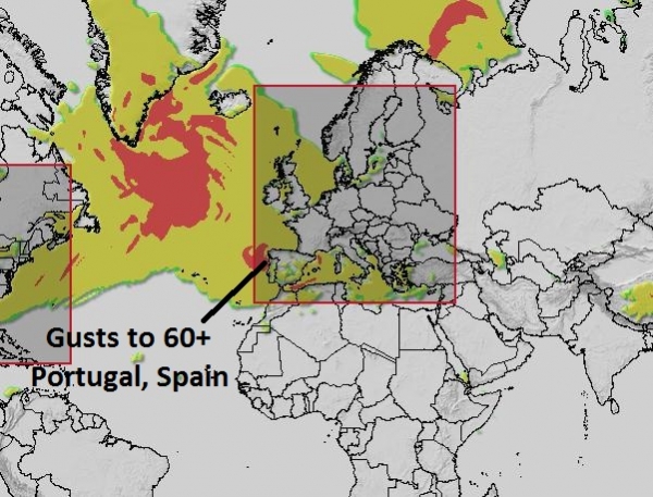
High Wind Potential. Our models show a potential
for 50-65 mph. wind gusts for coastal Portugal and Spain over the next
36 hours, as a family of intense storms pushes into Europe.
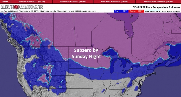
Coldest Air of Winter For Northern USA. The bitter
air we've been tracking for 2 weeks is poised to surge into the
northern USA from Saturday into the middle of next week. The map above
shows the cities forecast to experience subzero temperatures by Sunday
night, from the Dakotas, the Twin Cities to Madison, Milwaukee and
Green Bay. Wind chills will drop to -25 F. by Monday morning in many of
these major metro areas.
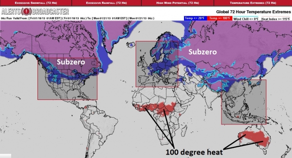
Remarkable Extremes. While much of Asia,
Scandanavia and North America experiences the coldest air of winter in
the coming 5-10 days, extreme heat continues to bake central Africa.
Historic heat gripping Australia in recent weeks has weakened slightly
over coastal areas, like Sydney and Melbourne, but the heat wave
continues to generate a variety of water-related problems, and the
brushfire risk remains very high.
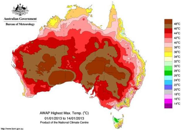
What's Causing Australia's Heat Wave? Here's an excerpt of a fascinating article at Australia's
The Conversation, focusing on the factors converging to create historic heat across the country: "...
And
it’s not like these sorts of days occur that often. The records set
last week sit between two and three standard deviations above the
long-term January mean of 35°C. Perhaps more unusually, the Australian
mean temperature (representing the average of the daytime maximum and
night-time minimum) set record high values on both days at 32.22
(January 7) and 32.32°C (January 8), that were well above the previous
high of 31.86°C, set in 1972. However, it is really the duration of this
extreme heat wave that makes it so unusual, and so significant in terms
of impacts..."
Graphic credit above: "Highest daily maximum temperature during the first two weeks of January." Australian Bureau of Meteorology.
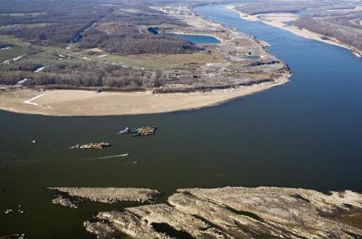
Keeping The Boats Moving Along A Mississippi Dwindled By Drought.
Things look a little better for navigation on the Mississippi, but
officials are still concerned about 2013 conditions, with drought
conditions upstream.
The New York Times has the story; here's an excerpt" "...
The
fact that the river has remained open for business along the critical
“Middle Miss” — the 200 miles between the Mississippi’s last
dam-and-locks structure, above St. Louis, down to Cairo, Ill., where the
plentiful Ohio River flows in — stems from a remarkable feat of
engineering that involved months of nonstop dredging, blasting and scraping away of rock obstructions
along the riverbed, effectively lowering the bottom of the channel by
two feet. It has also involved exacting use of reservoirs along the
vast river system that were initially designed by engineers using slide
rules nearly 100 years ago to try to manage both flood and drought, as
well as rock structures placed in recent years along the bank to
direct water and speed it up, a bit like a thumb over the end of a
garden hose..."
Photo credit above: "Barges work on
dredging the Mississippi River near Thebes, Ill., Jan. 8, 2013. Despite
withering drought that has caused record-breaking low water levels
that threaten to shut down traffic on the Mississippi River, it remains
open for business thanks to an engineering feat that lowered the
bottom of the channel by two feet." (Tyler Bissmeyer/The New York Times)
"Hurricane Hunters" Kept Relentless Watch On 2012 Storms.
Did you know that the Air Force flies their planes into (major) winter
storms, to gather more accurate data for NOAA's computer models? Here's
an excerpt of an article from the U.S. Air Force: "As
the nation rebounds from 19 named storms and 11 major hurricanes in
2012, a small but hardy military organization keeps relentless watch to
track and prepare for such disasters. Located at Keesler Air Force
Base, Miss., the 53rd Weather Reconnaissance Squadron, dubbed the
"Hurricane Hunters" of the Air Force Reserve, is the Defense
Department's sole organization dedicated to flying into tropical storms
and hurricanes. The unit has performed the mission since 1944. In a
"DOD Live" bloggers roundtable today, Lt. Col. Jon Talbot, 53rd WRS
chief meteorologist, and Capt. John Brady, a meteorologist with the
squadron, said collecting winter storm, hurricane and tropical cyclone
data for the National Weather Service is critical in mitigating loss of
life and property. Typically, a winter storm mission begins only if the
weather system will have a large, societal impact somewhere in the
United States, Talbot explained. "Winter storms kill more people than hurricanes do,"
Talbot said, noting his team's specialty in analyzing data over water,
where information is sparse. "If the National Weather Service is
seeing a lot of uncertainty in their [data], they'll contact our
liaison team."
Climate Stories....
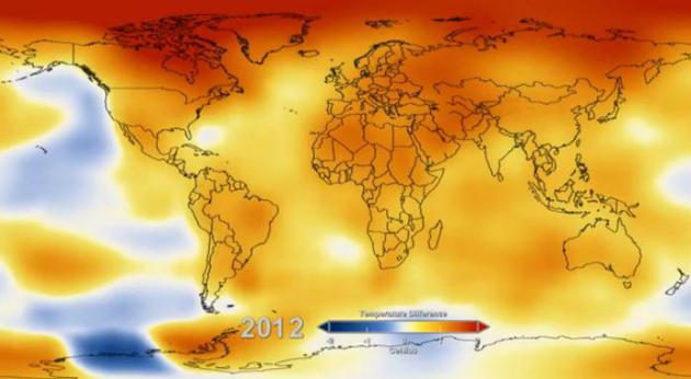
Watch 62 Years Of Global Warming In 13 Seconds. Climate Central has the remarkable
YouTube video clip, courtesy of NASA.
Global Warming Brings Earlier Spring Flowers. Here's an excerpt of a story at
Discovery.com: "...
They
found that as temperatures warmed over the last 161 years, the date of
first blooms of the season crept forward, too — about 10 days earlier
than when Thoreau first visited the site. During the record-breaking
years of 2010 and 2012, flowering happened a full 20 to 21 days
earlier. The average spring temperature at Walden Pond has increased
about 6 degrees Fahrenheit (3.4 degrees Celsius) since Thoreau's time..."
Photo credit above: "In incredibly detailed notebooks, Thoreau documented the flowering times of species such as the wild columbine." TBoard | Flickr.com.
How Climate Change Is Damaging The Great Lakes, With Implications For The Environment And The Economy. The Center for American Progress and
Think Progress have the story; here's an excerpt: "
Great Lakes Michigan and Huron set a new record low water level for the month of December, and in the coming weeks they could experience their lowest water levels ever.
It’s becoming certain that, like the rest of the country, the Great
Lakes are feeling the effects of climate change. Last year was
officially the warmest year
on record for the lower-48 states. The hot summer air has been causing
the surface water of the Great Lakes to increase in temperature. One
might think this causes more precipitation around the lakes, but the
warmer winter air is causing a shorter duration of ice cover. In fact,
the amount of ice covering the lakes has declined about 71 percent over the past 40 years. Last year, only 5 percent of the lakes froze over –- compared to 1979 when ice coverage was as much as 94 percent...."