The Cruelest Month
No, January in Minnesota is not for the timid.
But we're enjoying half a winter: plenty of cold, but legitimate snow
storms have become as rare as a Congressional compromise.
Remember when it would snow, fairly reliably,
every 2-4 days? Back when weather was leading the local news every other
day? 3 inches on the ground; 16.8 inches for the winter - almost 7
inches below average, to date.
Commutes have been easier, with 3 days of an
inch or more of snow (including that big dump of 10.5 inches on December
9). By now we should have picked up 6 days with an inch or more of
snowy goodness.
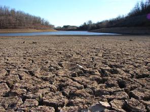
Droughts are stubborn things. We may be days
away from barge traffic grinding to a halt on the Mississippi. I keep
waiting for the pattern to change; for southern moisture to reach our
lofty latitude. I'll send up a flare when that glorious day arrives.
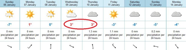
In the meantime Sunday shivers give way to a
symphony of gurgling drain spouts and drippy icicles this week; 3 or 4
days near 32 F.
A sloppy southern storm brushes us with a little
rain and drizzle late Thursday - a push of cold air next week sweeping
any moisture into the Great Lakes; a few subzero nights expected the
third week of January.
Good sleeping weather.
Midwinter Drizzle. NOAA data shows a high of 34 F.
on Thursday, temperatures in the lowest mile of the atmosphere above
freezing, meaning light rain or drizzle.
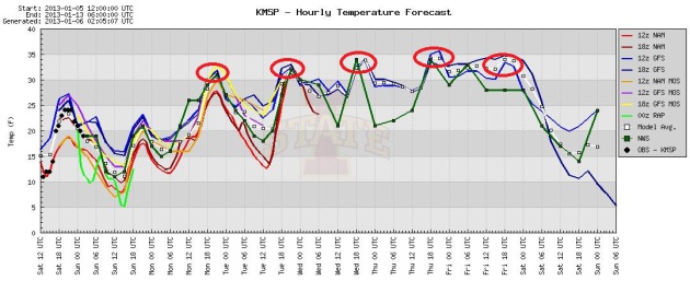
January Thaw. The models are in good agreement - you
will regain some feeling in your fingers and toes next week, with as
many as 4-5 days at or just above freezing. As we lose what little snow
we have on the ground temperatures stand a better chance of reaching
mid-30s by Wednesday and Thursday.
European Guidance. ECMWF data shows highs near
freezing by tomorrow afternoon, possibly mid 30s Wednesday and Thursday.
Most of the moisture stays east (again) on Thursday, a chance of a
little light rain and drizzle. Colder air arrives next weekend, shoving
the storm track farther east, away from Minnesota.
More Data On The January Thaw. Dr. Mark Seeley has some insight into the (almost) annual upward blip in temperatures in his weekly
WeatherTalk Newsletter: "...
Most
residents of the Twin Cities area consider the January thaw to be a
given each year. They know it will come, just not precisely when.
This time around it looks like next Monday through Thursday (Jan 7-10)
may bring a thaw period. Indeed for many central and southern Minnesota
locations a January thaw is quite common. The definition of a January
thaw is variable. Some consider it to be any single day with a
temperature above 32 degrees F. But consequences associated with a
January thaw, like loss of snow cover, melting and drying of street
surfaces and sidewalks, softening of lake ice, etc are generally not
realized unless temperatures rise above the freezing mark for two or
more days. Using this as a sorting criteria we can look at the
historical frequency of such temperatures for various locations in
Minnesota. These frequencies of January thaws (listed below) indeed
show great reliability in most of southern Minnesota, and even parts of
central Minnesota, but more like a 50/50 probability in the northern
sections of the state..."
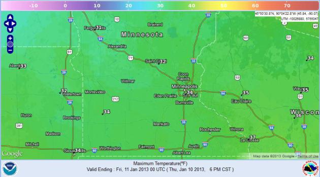
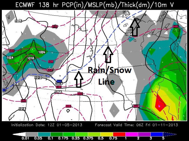
Thursday: Warm Enough For Rain/Drizzle. European
model guidance valid Thursday evening shows a little light rain and
drizzle into southeastern and east central Minnesota, heavier rain from
St. Louis it Chicago. Yes, it should be warm enough for rain on January
10. Map courtesy of WSI.
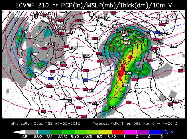
Another Close Encounter Early Next Week? The push of
cold air behind Thursday's light rain/drizzle event may be strong
enough to set up a storm track late Sunday and Monday - one that's just
100-200 miles too far east for significant snow in the Twin Cities. So
close, and yet so far...
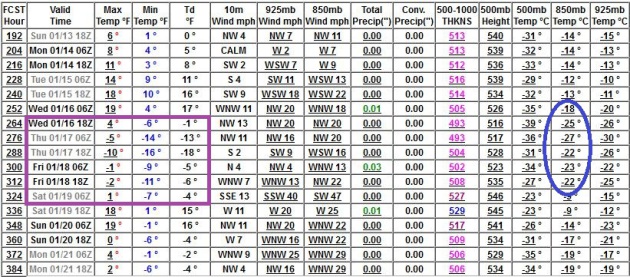 Coldest Air Of Winter?
The models are trending colder again for the third week of January; the
latest GFS run hinting at 3-6 subzero nights, maybe even a subzero
daytime high or two, with the very coldest weather predicted between
January 16-19. Still time to troll your favorite web site for a discount
fare to somewhere toasty.
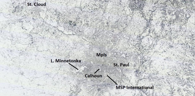
An Icy Landscape. NASA's 250 meter resolution
MODIS imagery
shows the dark gray smudge of the Twin Cities metro. Flat, undeveloped
farmland shows up as bright white, as does Lake Minnetonka and the Inner
Lakes south of Minneapolis.
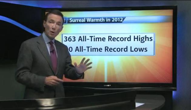
"Surreal Warmth" in 2012. Here's another 2:30 minute video recap on
YouTube, looking back at the extraordinary warmth of 2012, courtesy of WeatherNation TV.
Warm Year: 2012. Here's an excerpt of a great overview of record warmth across the great state of Minnesota last year - courtesy of the
Minnesota Climatology Working Group: "
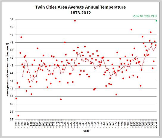
2012
will finish in a tie with 1931 as the warmest year on record in the
Twin Cities and will range from the warmest to third warmest on record
depending on the location around the region. For so long, it appeared
like 2012 would be the warmest year on record for the Twin Cities, but
then winter decided to arrive as if on cue on December 21 and since
then temperatures have been mostly below normal. As a result, the
average temperature for the Twin Cities for 2012 will wind up to be
50.8 degrees, the same as the 50.8 degrees recorded in 1931. The
1981-2010 average temperature for the year is 46.3 degrees so 2012 will
finish 4.5 degrees above normal. Every month of 2012 was above normal
except October which finished 1.4 degrees below normal. March 2012 was
15.5 degrees above normal and greatly assisted in lifting the average
temperature for 2012. The hottest day of 2012 in the Twin Cities was 102
degrees on July 6 and the coldest temperature of the year was -11 on
January 19."
Twin Cities (1873-2012)

Rank Year Average
-----------------
1.   1931   50.8
     2012   50.8
3.   1987   49.7
4.   2006   49.3
5.   1998   48.8
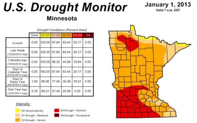
How Long Will Minnesota's Drought Linger? State Climatologist Greg Spoden adds some personal thoughts to his monthly
HydroClim summary: "
It
is reasonable to assume that the present drought status will remain
relatively unchanged for the remainder of the winter. The historical
average precipitation over the next two months is less than two inches
and the topsoil is sealed by frost. Therefore, Minnesota will be highly
dependent on spring rains to ease the situation. Without abundant
spring rains, a number of critical drought issues involving public water supply, agriculture, horticulture, tourism, and others will rapidly surface early in the growing season." (the latest Minnesota Drought Monitor information is
here).
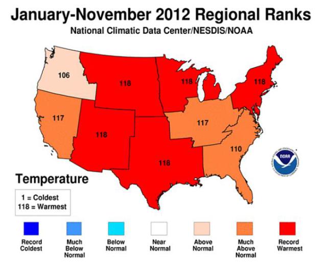
Preliminary Data.
NOAA NCDC
data shows that January - November was the warmest on record for a big
chunk of the USA. Every region in bright red experienced the warmest
year in 118 years of record-keeping.
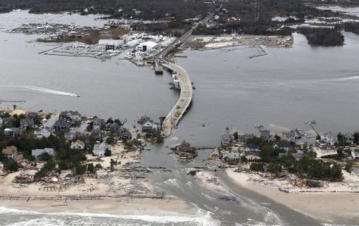
Region Chops Sandy Debris Down To Size. Here's an eye-opening clip from an article at
The Wall Street Journal: "
The
immense task of leveling the mountains of debris left behind by Sandy
is coming into focus two months after the historic superstorm ravaged
the East Coast. In the end, the federal government estimates that 16
million cubic yards of debris piled up around New York and New Jersey—enough to fill the Empire State Building 16 times over—though more than half has yet to arrive at landfills..."
Photo credit above: "
A aerial view of the damage in
Mantoloking, N.J., caused by Hurricane Sandy, Oct. 31, 2012. President
Barack Obama toured New Jersey's ravaged coastline with New Jersey Gov.
Chris Christie in a display of big-government muscle and bipartisan
harmony." (Doug Mills/The New York Times)
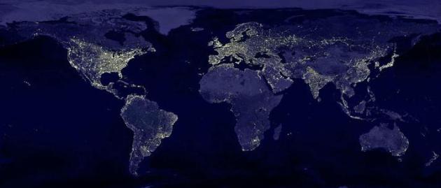
Earth At Night.
National Geographic
has a very nice view showing the proliferation of light pollution
across the planet. Getting a clear look at astronomical targets has
never been more challenging: "
Luminous patches glow on a map of
nighttime Earth created from satellite and ground data on scattered
light as of 1996-97. The situation is even worse today. Based on
calculations, two-thirds of humanity lives under skies polluted with
light, and one-fifth can no longer see the Milky Way. Least affected?
The Central African Republic."
Favorite pics....
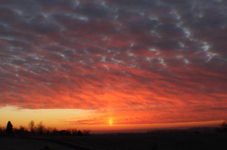
Sun Pillar. Laura Everly Daugherty snapped this
photo at Beaver Dam, Kentucky Saturday morning, ice crystals sparking a
faintly visible column of light above the rising sun. Photo courtesy of
WeatherNation TV.
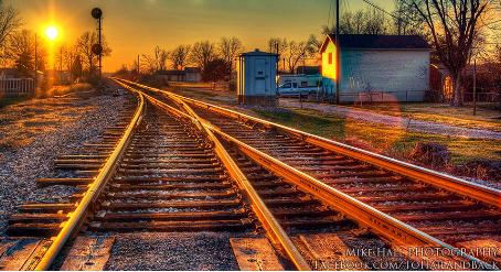
Riding The Rails. Mike Hall captured this pic at Lewistown, Kentucky yesterday. Very nice.
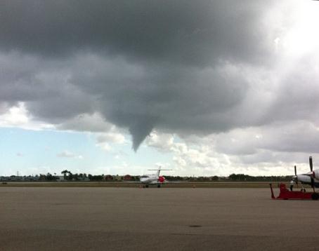
Funnels Over Miami. @ComplexJesse snapped this photo
of a developing funnel cloud over Miami International Airport Friday
afternoon; courtesy of WeatherNation TV.
Climate Stories...
Climate Change Won't Wait. Here's an excerpt of an Op-Ed from Bill McKibbon in the
Los Angeles Times: "...
If
he were serious, Obama would be doing more than just the obvious and
easy. God knows he had his chances in 2012: the hottest year in the
history of the continental United States, the deepest drought of his
lifetime, and a melt of the Arctic so severe that the federal
government's premier climate scientist declared it a "planetary
emergency." In fact, he didn't even appear to notice those phenomena,
even as people in the crowds greeting him along the campaign trail were
fainting from the heat. Throughout campaign 2012, he kept declaring
his love for an "all of the above" energy policy where, apparently, oil
and natural gas were exactly as virtuous as sun and wind. Only at the
very end of the campaign, when Superstorm Sandy
seemed to present a political opening, did he even hint at seizing it.
His people let reporters know on background that climate change would
now be one of his three priorities for a second term (or maybe,
post-Newtown, four). That's a start, I suppose, but it's a long way from
concrete action..."
Full Page Ad To Appear in Hawaiian Newspaper Pressuring Obama On Climate Change.
USnews.com has the story; here's the introduction: "
As
President Barack Obama wraps up his vacation to Hawaii, he'll be
greeted with a full-page ad Saturday urging him to take action on
climate change. The ad, appearing in Hawaii's main paper, the Honolulu
Star-Advertiser, appeals to Obama's origins and legacy. "The 'aina is
part of our legacy, Mr. President, and yours," the ad reads, using the Hawaiian word for "earth." "If we fail to act, rising sea levels, super storms, and droughts will forever change these islands, our nation and the world."
Ending The Silence On Climate Change. Check out the video at
billmoyers.com: "
Climate
change communication expert Anthony Leiserowitz explains why climate
change gets the silent treatment, and what we should do about it."
Facebook And The Rest Of Silicon Valley Could Be Wiped Out In 40 Years. Hype, or a real concern with rising sea levels? Here's an excerpt from a story at
Business Insider: "
While
much of California's coastline is at risk of rising sea levels, things
look particularly bad for the Bay Area. Silicon Valley is already 3-10
feet below sea level, and scientists say that seawater will rise 16
inches by 2050. By 2100, that number is supposed to jump to 65 inches,
and the entire area will experience more frequent, hard-hitting storms.
If the levees in place are destroyed or overwhelmed by a storm surge,
one hard blow could put the 3 million people who live in Silicon Valley
in a grisly Waterworld. "It's imminent," Mruz says. "There's no
question in my mind; we're going to have to do something, at every spot
around the Bay." Also at risk: Google, Yahoo, LinkedIn, Intel, Cisco, and Oracle.
"Silicon Valley basically backs right up to the bay," Mruz told CW.
"You have all of them, Yahoo, Google, all right there. Without some type
of flood protection potentially in front of that, you could flood that
whole area. You're talking billions of dollars..."
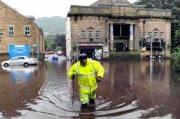
Scientists Link Global Warming To England's Rainiest Year On Record. This article at
euractiv.com caught my eye; here's an excerpt: "
Senior
climate scientists are linking global warming to the UK Met Office's
announcement yesterday (3 January) that 2012 was England’s rainiest
year since records began. The weather service's numbers showed that due
to slightly more seasonal figures in Wales and Scotland, the UK as a
whole experienced its second wettest summer recorded. But four of the
UK’s Top Five wettest years have now occurred since 2000, a statistic in line with the expectations of climatologists
who model the effects of a warming world. “It is not just Britain but
many other parts of northern Europe and north America that are getting
wetter and there is a climate change component to it,” Kevin Trenberth
told EurActiv over a phone line from the US National Center for
Atmospheric Research in Boulder, Colorado..."
Climate Change: What's Faith Got To Do With It? Here is an excerpt of an article that resonated with me, from California's
Whittier Daily News: "
Throughout
all of California and the rest of the country, the faith community has
been working for many years to preach the gospel of good stewardship
of our shared environment. Amid theological differences, we have
fostered a shared sense of purpose and urgency that unites us in
solidarity with our local and global communities, especially those most
vulnerable to climate change. The action that results from this shared
sense of purpose goes far beyond a congregation's four walls. People of
faith bring shared principles - such as working for the common good,
caring for our neighbors, and working for economic justice - into the
public policy arena..."
Global Warming And Drought In The Midwest: Expect More Of The Same? Here's a snippet of a story at
chicagomag.com: "
The
Midwest drought of 2012 has been one of the most expensive natural
disasters of recent decades, with Mississippi River barge traffic on the
verge of shutting down, and the Army Corps of Engineers blowing up underwater limestone to keep traffic moving:
‘If we were in the same conditions now, 30 years ago, we`d be running into problems much, much, sooner,’ Col. Hall said.
The rock removal does stop traffic for 16 hours every day. But the
Coast Guard, the river`s `traffic cop`, unclogs the jam overnight.
‘During the time that the Army Corps contractors are removing rock,
which is roughly 6:00am – 10:00pm at night, we gather up all the vessels
that are waiting north and south,’ Capt. Teschenford said. ‘They
actually do a quick survey of the area where rocks were removed and we
open it up. ‘