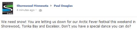
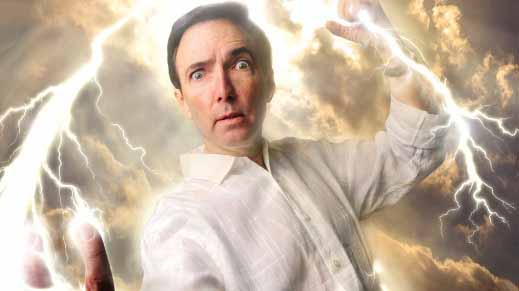
I'm "Dancing"
Here's how my Monday started; a tweet from the
city of Shorewood: "We need snow! You are letting us down for our Arctic
Fever Festival this weekend in Shorewood, Tonka Bay & Excelsior.
Don't you have a special dance you can do?" I wish it was that simple.
And you've never seen me dance.
Picture a guy having convulsions while snapping his fingers.
If I could dance, or kick the Doppler, push a button to end our drought, I would in a heartbeat.
We're at the mercy of larger patterns. Until
Pacific storms carve out a persistent trough of low pressure over the
Rockies, and steering winds howl from New Mexico and Texas, it's going
to be tough getting significant moisture in here.
At least we've picked up 16.9 inches this winter
at KMSP. Chicago has seen just over 1 inch. The drought signal is still
holding strong.
A dusting of flurries is possible Wednesday as
temperatures try to thaw; more 30s possible Friday. A couple inches of
dry, fluffy, powdery snow may fall Monday as the coldest air of winter
cascades south. Highs may hold below 0 over much of Minnesota next
Monday & Tuesday. Temperatures rebound nicely by late January.
Next week we'll all be dancing (and snapping our fingers?) just to stay warm.
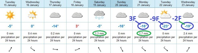
Fun With Negative Numbers. Enjoying the warm
front? A week from today there may be some serious gripes: cars that
won't start, minor cases of frostbite down at the bus stop. ECMWF model
guidance shows a warming trend, a shot at 30-32 F. by Wednesday, maybe
low 30s Friday. An Alberta Clipper brushes MSP with a coating to an inch
or so of snow Saturday, followed by single digits Sunday and Monday.
The core of the coldest air arrives next Tuesday, with a "high" of -9,
and wind chills dipping to -20. Lovely. Time to cash in those frequent
flier miles.
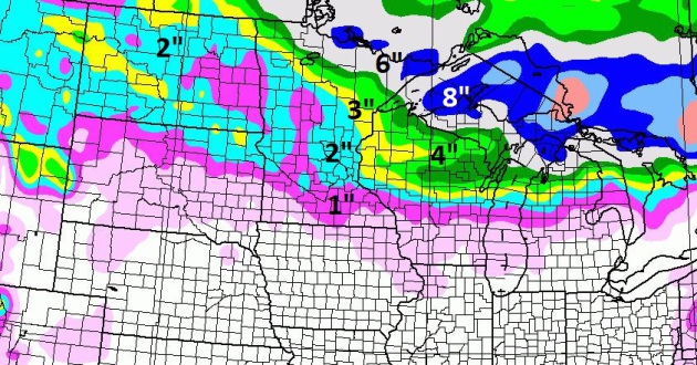
Predicted Snowfall By Midday Saturday. NAM guidance
shows the impact of a series of clippers, as much as half a foot of new
snow for far northern Minnesota, maybe 3-4" for Duluth and Grand Rapids
(for Saturday's Mega-Hockey Festivities), possibly an inch or two for
the Twin Cities metro by Saturday afternoon.
A Real January. Last year was a gift, at least for
Minnesotans who love snow and cold. This year? Not so much. I still
don't see significant snow, but numbing air will surge south in a couple
of "waves", one arriving early next week, another the last few days of
January, if GFS model data can be believed. My confidence level is
fairly high we'll see a few subzero nights (and days) early next week; a
lower confidence level about another outbreak at the very end of the
month. No sign of spring fever.
3.7" snow so far this season at Kansas City.
1.3" snow so far this winter in Chicago.
35 F. low at LAX International Airport in Los
Angeles Monday morning, the coldest in 23 years - tying the old record
low set in 1990. The all-time record low for L.A.? 28, most recently set
in 1949. NBC Southern California has
details.
January Weather Flip-Flops. In Monday's edition of WeatherNationTV's
Climate Matters I take a look at some of the wild extremes, here in the USA and worldwide: "
One
side of the country is experiencing record heat. The other side record
cold. Who would ever guess the low temperature this morning was
warmer 16 degrees warmer in Boston than Los Angeles? For more on the
wacky January weather flip flop here's Meteorologist Paul Douglas."
* here's a chronological look at all the climate segments I've prepared, available on
YouTube (latest clips at screen bottom).
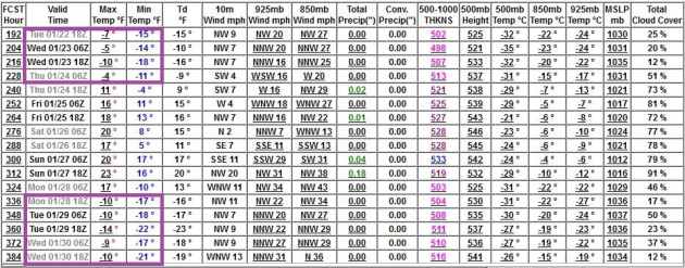
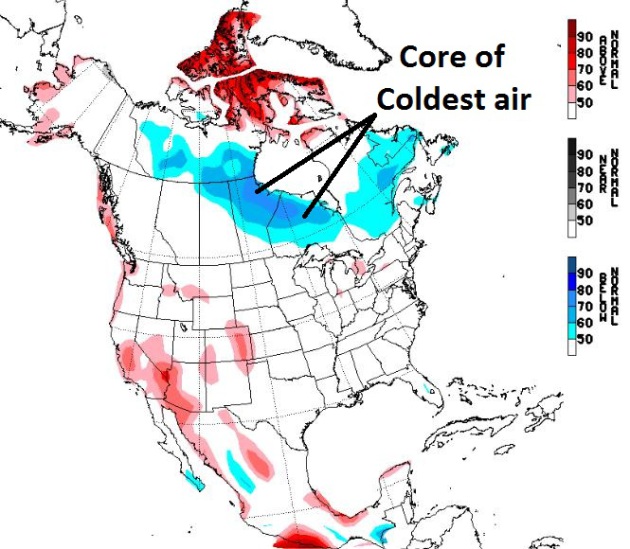
A Very Close Encounter. Although the extended
"NAEFS" temperature outlook from NOAA (above) from January 22-28 keeps
the core of the most bitter air a few hundred miles to our north, I
expect subzero air to brush Minnesota early next week, possibly the
coldest outbreak of the winter. Another (brief) subzero encounter is
possible by late January, but the core of the very coldest air may pass
just north/east of MSP.
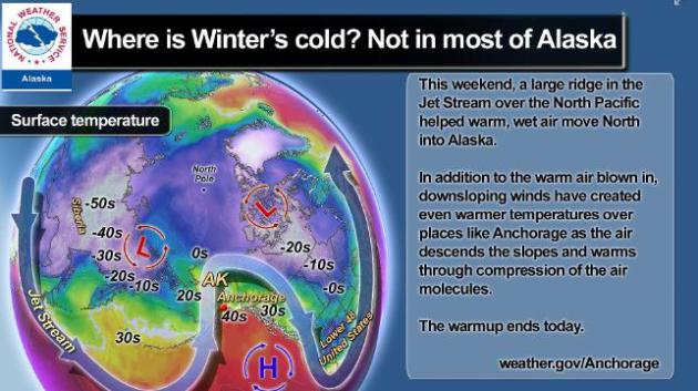
Alaska Forecast To Cool Down Again. Alaska has been
unusually mild (near 40 in Anchorage over the weekend) with rain
penetrating into the interior. But models show Alaska chilling down
again in the coming week. When Alaska is mild Minnesota is (often)
bitterly cold, and vice versa. I sense our coldest weather of winter
will come early next week, followed by slight moderation by the end of
January. Details from the
Anchorage office of the NWS: "
Mild air continues to melt southcentral Alaska’s snow and ice this afternoon. Short, warm spells such as this during Winter
are not unusual for the area. The primary cause for the warmup is the
configuration of the Jet Stream, the fast-moving river of air that
circles the Earth and drives the weather below."
I Feel Your Pain. Not only is the lack of snow bad
for snow lovers and winter events around the state, it doesn't bode well
for our ongoing, 6-month old drought. According to local climate
experts what will make all the difference is whether we see heavy wet
snow and/or significant rain in late winter and early spring, once the
ground has a chance to thaw out, and moisture can absorb into topsoil.
If we don't see significant moisture with a shift in the pattern, the
current (severe) drought in the metro could eventually rival what we
experienced back in 1988. Let's hope that doesn't come to pass. I'll
kick the Doppler (again) and see if Old Man Winter is in the mood for
snow. Don't hold your breath.
Ask Paul. Weather-related Q&A:
Hi Paul,
"I begin my morning with your column (wanting
to know when I get to use my snowmachine!). Do you have powers to make
that happen? Quick question on the precipitation per 24
hours. It is written as mm/24 hours but for instance on Sunday you are
predicting the possibility of a couple of inches yet the 3.5mm/24 hours
only amounts .14inches. Is there something I am missing here in terms
of precipitation and snowfall amounts?"
Thank You,
Levi Kraft
Hi Levi - I appreciate you being a loyal reader;
and wish I could hit a button and make it snow. Next company? The
lawyers would have a field-day with that. Your question is a good one,
and here is why (IF) it snows Sunday amounts could be more than .14"
liquid would imply. When it's bitterly cold (single digits or teens)
snowfall ratios can be close to 30 to 1; 30" of snow for every inch of
liquid precipitation. Around 30 F. that ratio is closer to 10 to 1. So
assuming we do see a vigorous clipper out ahead of what may be the
coldest front of winter, that .14" could wind up being 2 or even 3" of
light, fluffy, powdery snow. The colder the temperature, the more air
between the flakes - like a featherbed the snow gets pumped up. Nothing
definite yet. That old adage "when in a drought don't forecast rain...or
snow" is ringing in my ears. Stay tuned.
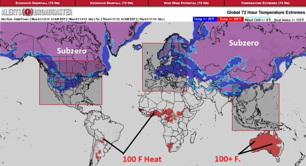
Serious Extremes. Welcome to the "dead of winter"
over the Northern Hemisphere. Historically, this is the week where
temperatures bottom out, and the next 1-2 weeks promise to be the
coldest of the winter for Canada and the northern tier of the USA, as
well as Scandanavia and much of Russia/Siberia. Meanwhile 100-degree
heat is baking Argentina, central Africa and much of Australia. 72 hour
GFS-based extreme forecast courtesy of Ham Weather.
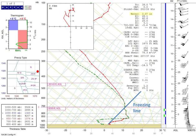
Thursday Evening's Balloon Launch Sets New Record.
The weather balloon launched by the Twin Cities NWS last Thursday
evening set a record for the most moisture ever encountered above the
Twin Cities during the month of January. Warmer air can hold more water
vapor (this is a simplification, but true) and last week's balloon
launch was historic. Details from the
KMPX NWS: "
The
balloon launched at 6 pm on Januar 10th, 2013 (midnight GMT January
11th) set a record for the most moisture ever recorded by a weather
balloon in the month of January since balloons began to be released
regularly twice a day at St. Cloud in 1948 (moved to Chanhassen in 1995)...."
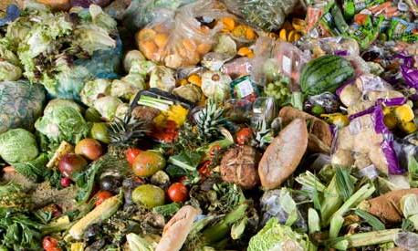
Almost Half Of The World's Food Thrown Away, Report Finds. That's a sobering statistic;
The Guardian has the story - here's an excerpt: "
As much as half of all the food produced in the world – equivalent to 2bn tonnes – ends up as waste every year, engineers warned in a report published on Thursday.
The UK's Institution of Mechanical Engineers (IMechE) blames the
"staggering" new figures in its analysis on unnecessarily strict sell-by
dates, buy-one-get-one free and Western consumer demand for
cosmetically perfect food, along with "poor engineering and agricultural
practices", inadequate infrastructure and poor storage facilities. In
the face of United Nations predictions that there could be about an
extra 3 billion people to feed by the end of the century and growing
pressure on the resources needed to produce food, including land, water
and energy, the IMechE is calling for urgent action to tackle this
waste..."
Photo credit above: "
Between 30% and 50% or 1.2-2bn tonnes of food produced around the world never makes it on to a plate." Photograph: Murdo MacLeod for the Guardian
"iPotty: Toilet Training, Now With Added iPad. Is it wrong to want an adult version of this? It is? O.K. Never mind.
Gizmag.com has more details if you have a toddler who loves to multitask: "
It's
an unspoken truth of gadgets that some people use their smartphone or
even tablet computer while in the bathroom. Now even toddlers who are
yet to master the toilet can get in on the action with iPotty – a
child's toilet training potty with a built-in iPad stand..."
The Perils Of Auto-Correct. Why does my smartphone
hate me? The examples above were part of a very funny (and raunchy) post
of the 25 Funniest AutoCorrects of 2012 from Buzzfeed. OMG.
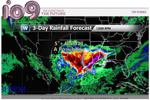
Weather Forecast Calls For Heavy Rainfall, 50% Chance Of Batman. WeatherNation TV is making news, in rather unusual ways. Here's an excerpt of a post at
io9.com: "
Over at Newton Blog, Ross Pomeroy serves up a great example of misperceived random stimuli in the form of a 3-day rainfall forecast. The screenshot, he says, was captured by a friend working at Weather Nation,
and comes from the Rapid Precision Mesoscale weather forecasting
model. Tempting though it may be to take the model as a sign of
Batman's return, Pomeroy rightly chalks its resemblance up to pareidolia..."
Climate Stories...
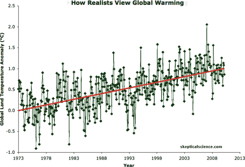
Debunking The Denial: "16 Years Of No Global Warming". Here's an excerpt from
Slate: "
The
difficulties in debunking blatant antireality are legion. You can make
up any old nonsense and state it in a few seconds, but it takes much
longer to show why it’s wrong and how things really are. This is coupled
with how sticky bunk can be. Once uttered, it’s out there,
bootstrapping its own reality, getting repeated by the usual suspects.
Case in point: The claim that there’s been no global warming for the past 16 years.
This is blatantly untrue, a ridiculous and obviously false statement.
But I see it over and again online, in Op Eds, and in comments to
climate change posts..."
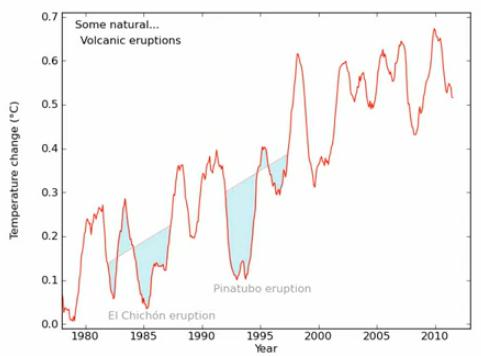
More Detail On "No Warming In 16 Years Meme". The
key is to look at the true global temperature trend, subtracting out
other forcings like volcanic eruptions, solar variations and La Nina and
El Nino. John Cook at Skeptical Science has a great
YouTube clip that explains this in detail.
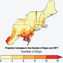
Federal Climate Report Predicts Spike In Hot Days For Washington D.C. By Mid-Century.
Our nation's capital, which is already "stinking-hot" most summers, may
become even more inflamed by the middle of the 21st century.
The Capital Gang's Jason Samenow reports: "
Washington, D.C. just experienced its warmest year on record, and its three hottest summers in as many years.
The message from the draft of a newly released federal report? Get
used to it. The draft National Climate Assessment (NCA) posted Friday
afternoon says the punishing, record-setting streak of 11 straight days above 95 D.C. experienced last summer is exactly the kind of event that may occur with increasing regularity in the future..."
Map credit above: "
Increase in number of days above 95 degrees by mid-century (2041-2070 compared to 1971-2000) under high emissions scenario." (NCA)
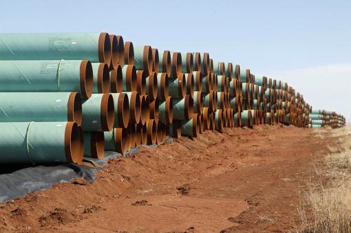
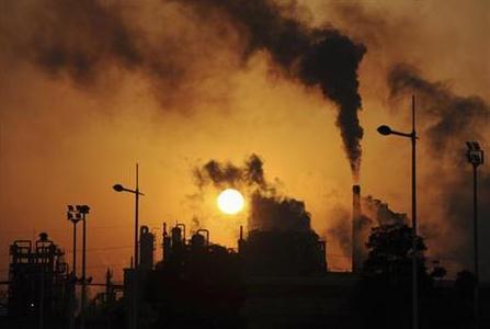
Clearing The Air On Oilsands Emissions. What to
believe about the proposed Keystone Pipeline and it's impact on
greenhouse gas emissions? Here's an excerpt of a good overview from
The Pembina Institute: "
This
backgrounder provides an overview of how oilsands production and
expansion contributes to greenhouse gas pollution and climate change,
focusing on six key issues:
- Average oilsands production is significantly more greenhouse gas-intensive than conventional oil production.
- Oilsands are the fastest growing source of greenhouse gas emissions in Canada.
- Alberta’s greenhouse gas regulations do not result in meaningful reductions in emissions from oilsands operations.
- Large-scale carbon capture and storage for oilsands
emissions is unlikely due to high capital cost and lack of regulatory
driver..."
Photo credit above: "
In this Wednesday, Feb. 1, 2012 file
photo, miles of pipe ready to become part of the Keystone Pipeline are
stacked in a field near Ripley, Okla. The controversy over the pipeline
in the hub of Oklahoma's oil activity, was voted the number nine story
of the state for 2012." (AP Photo/Sue Ogrocki, File) Geology.com has another good primer on oil sands
here.
Climate Change Measures: Report Praises Politicians.
This may be so in other countries around the planet, but here in the
USA? You'd be hard-pressed to find many politicians to praise on this
topic these days.
The BBC reports: "
Politicians
are doing more to combat climate change than they are given credit for,
according to a report. It says 32 out of 33 countries surveyed have
introduced, or are producing, significant climate-related laws. Out of
these, 18 nations are making "significant" progress, with some emerging
economies taking a lead. The Globe group of parliamentarians, which
published the report, admits that emissions are still growing at a
dangerous level. But Globe president John Gummer, the former Environment
Secretary, says progress on a national level gives some cause for
optimism. "The tide is beginning to turn decisively on tackling climate
change, the defining material challenge of this century," he said..."
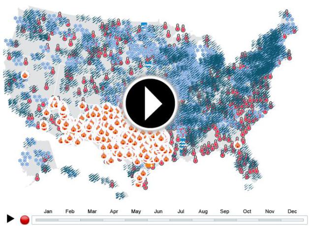
Extreme Weather Map 2011. A friend forwarded me this link and timelapse animation from
NRDC,
the Natural Resources Defense Council - looking back at 2011, possibly
the most extreme year for U.S. weather since the early 1800's. Here's an
excerpt: "
Climate change increases the risk of record-breaking extreme weather events that threaten communities across the country. In 2011, there were 3,251 monthly weather records broken by extreme events that struck communities in the US. Check out the interactive map below to find out what events hit your area."
Minnesota experienced in 2011:
- Record-breaking heat in 13 counties and a total of 16 broken heat records
- Record-breaking rainfall in 21 counties and a total of 34 broken rainfall records
- Record-breaking snow in 16 counties and a total of 21 broken snowfall records
- Extreme flooding
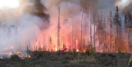
Climate Change Fuels Wildfires Around The World.
Deutsche Welle
has a story focused on the link between climate extremes (hot, dry
areas becoming even hotter and drier) and the potential for major
wildfires; here's an excerpt: "
Every year, large areas of the
Earth's surface burn, and the number of fires is increasing. Is climate
change fanning the flames? Or are the fires making climate change
worse? The climate is complex. It is so complex that it's difficult for
researchers to give accurate climate forecasts because it is so heavily
influenced by external factors – solar radiation, greenhouse gasses
and oceans. Another factor, which has been largely ignored until now,
is fire. Only recently have experts realized that large forest and bush
fires are noticeably changing the climate while being affected by it.
"Every year, more than 400 million acres (160 million hectares) are
burnt. That's an area bigger than the size of India," says Silvia Kloster from the Max Plank Institute for Meteorology in Hamburg..." (Image credit: Minnesota DNR).
Climate Change Study: Emission Limits Could Avoid Damage By Two-Thirds. Here's the intro to a story from Reuters and
Huffington Post: "
The
world could avoid much of the damaging effects of climate change this
century if greenhouse gas emissions are curbed more sharply, research
showed on Sunday. The study, published in the journal Nature Climate
Change, is the first comprehensive assessment of the benefits of
cutting emissions to keep the global temperature rise to within 2
degrees Celsius by 2100, a level which scientists say would avoid the
worst effects of climate change. It found 20 to 65 percent of the
adverse impacts by the end of this century could be avoided. "Our
research clearly identifies the benefits of reducing greenhouse gas
emissions - less severe impacts on flooding and crops are two areas of
particular benefit," said Nigel Arnell, director of the University of
Reading's Walker Institute, which led the study..."