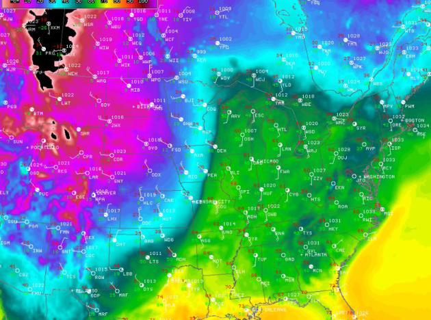
Here's the cold front that we're dealing
with... quite a front, eh? Temperatures within a few hundred mild span
are nearly 50F different!
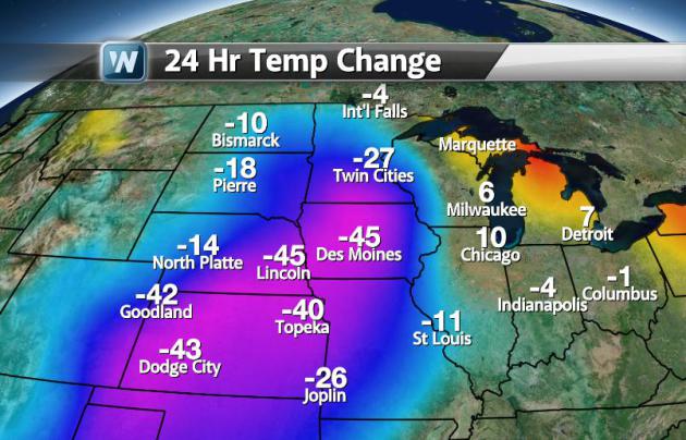
24 Hour Temp Change
Impressive 24 hour temperature changes were
common across the mid-section of the nation on Sunday. In some cases,
there were 50F swings. The graphic below is just a snapshot of how
dramatic it was at one point Sunday.
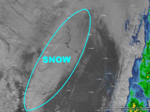
Snow From Space
This is what the visible satellite revealed
on Sunday as skies began to clear across the Plains. That white strip
you see is the large snow swath that was deposited from the powerful
Pacific storm. There was quite a bit more across parts of Montana and
other mountainous states, but this is what it looked like east of the
Rockies.
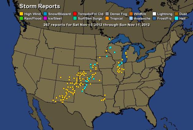
Severe Weather
With such a dynamic system, severe weather
isn't all that uncommon/unusual. Take a look at the storm report map
from over the weekend.
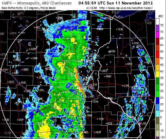
Nasty Storms
This is just a sample of what some of the
thunderstorms looked like. The radar image below was from Saturday night
as a line of straight line wind producing storms rolled through the
Twin Cities. There were several reports of damage; uprooted trees,
downed power lines and structural damage.
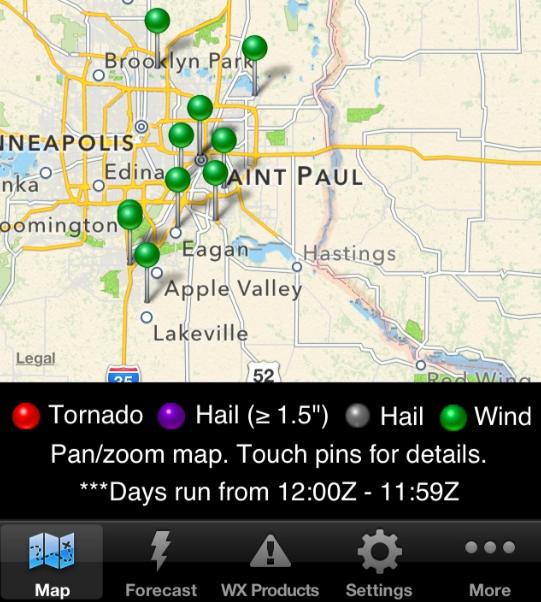
Twin Cities Damage Reports
These are the storm reports from around the Twin Cities as the moved through Saturday night.
0500 UNK LAKEVILLE DAKOTA MN 4468 9324 TREES DOWN. TIME ESTIMATED. (MPX)
0500 UNK BURNSVILLE DAKOTA MN 4476 9328 TREES DOWN. TIME ESTIMATED. (MPX)
0503 UNK 1 S BURNSVILLE DAKOTA MN 4475 9328 STRUCTURAL DAMAGE TO RESIDENTIAL HOUSE ... SHINGLES OFF. (MPX)
0503 UNK 1 NNW MENDOTA HEIGHTS DAKOTA MN 4490 9315 STRUCTURAL DAMGE TO SENIOR RESIDENTS ... ROOF DAMAGE. FRESH LAID SOD WAS PILED UP NEXT TO BUILDING. TEMPORARY EVACUATION FOR STRUCTURAL ASSESSMENT. (MPX)
0506 UNK EAGAN DAKOTA MN 4482 9316 TREES DOWN. TIME ESTIMATED. (MPX)
0506 UNK INVER GROVE HEIGHTS DAKOTA MN 4483 9306 TREES DOWN. TIME ESTIMATED. (MPX)
0512 UNK LILYDALE DAKOTA MN 4492 9313 LILYDALE POOL AND YACHT CLUB ... CANOPY TORN OFF. DECK FURNITURE DAMAGED. MINOR STRUCTURAL DAMAGE INCLUDING A BROKEN ENTRY DOOR. (MPX)
0515 UNK SOUTH ST PAUL DAKOTA MN 4489 9304 TREES AND POWER LINES DOWN. TIME ESTIMATED. (MPX)
0515 UNK MOUNDS VIEW RAMSEY MN 4511 9321 TREES DOWN. TIME ESTIMATED. (MPX)
0516 70 ST PAUL RAMSEY MN 4495 9310 (MPX)
0516 UNK ST PAUL RAMSEY MN 4495 9310 NUMEROUS REPORTS OF LARGE TREES DOWN AND DUMPSTERS IN STREET. NEAR ST PAUL AIR PORT. TIME ESTIMATED. (MPX)
0520 UNK MAHTOMEDI WASHINGTON MN 4506 9296 NUMEROUS TREES DOWN AND POWER LINES DOWN. TIME ESTIMATED.
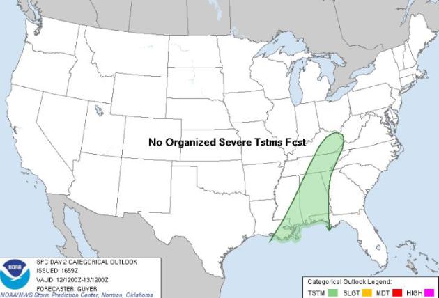
Monday Severe Weather Outlook
The good news is that the severe weather
threat for Monday should be minimize quite a bit. It appears as if the
cold front will lose some of its punch as it works east of the
Mississippi Valley. It'll still be quite a cool front, but the severe
weather threat looks to be diminished by quite a margin! The area in
green below is a general thunderstorm outlook for Monday, note that
there is no organized severe thunderstorms forecast!
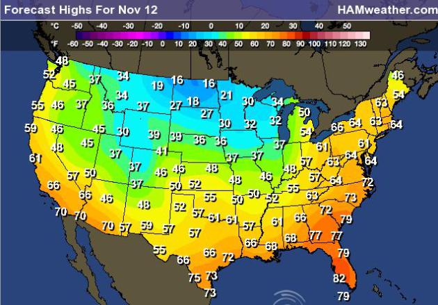
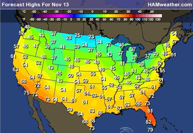
Forecast Highs - Post Cold Front
Considering how warm it was over the
weekend east of the Mississippi Valley, temperatures Monday and Tuesday
will be quite a bit cooler.
Highs Monday:
Highs Tuesday:
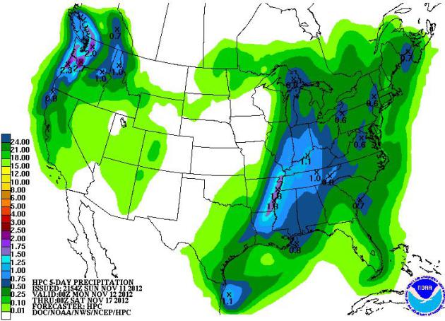
Precipitation Forecast
As the front pushes east, showers and
storms will head east along with it. NOAA's HPC 5 day precipitation
forecast suggests up to 2" in a few spots across the Lower Mississippi
Valley early this week. Note also the next sure of Pacific moisture
moving into the NW!
Developing Nor'Easter?
I hope this is just a hiccup in the weather
models, but the latest GFS models is hinting at a developing storm
across the eastern seaboard a few days prior to Thanksgiving. It's not
set in stone yet and I hope it's wrong, but it's something to watch
especially if you have travel plans next week!

Thanks for checking in, have a great week ahead!
Don't forget to follow me on Twitter @TNelsonWNTV