Where's the snow?
Some folks may be asking that question after a fairly dismal start (for most) to the 2012-2013 winter season. Other than a few heavy pockets of snow across parts of the nation so far, the rest of the nation has been lulled to sleep by a rather quiet weather pattern as of late. Here are a couple of 'snowy' webcams that I could find from Thursday.
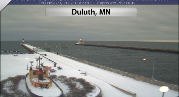
Duluth, MN
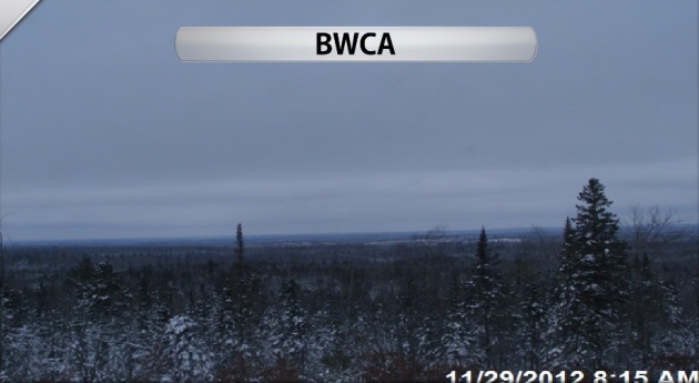
BWCA - Northeastern MN
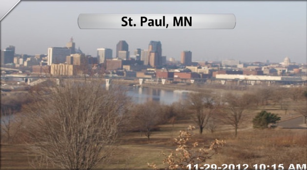
Snowless in St. Paul
If folks in Seattle are sleepless, then folks in St. Paul are snowless. This was the webcam from St. Paul, MN earlier Thursday, which showed a pretty barren looking landscape.
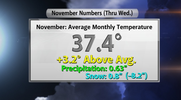
Twin Cities November Numbers
November 2012 will go in the books as a fairly dry and snowless month. In fact, the Twin Cities will end up nearly an inch below normal November precipitation. That along with temperatures running nearly 3.5F above average allowed for WELL below normal snowfall. November snowfall is at a whopping 0.8" (nearly 8.0" below normal for the month and almost 8.5" below normal for the season. The numbers listed below are climate numbers as of Wednesday, November 28th.
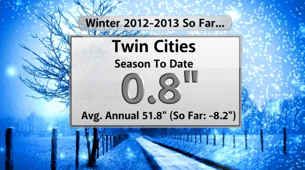
2012-2012 Winter Season So Far...
Even though meteorological winter doesn't start until Saturday, the official seasonal snow totals are based from July 1st. So far this winter, things have been pretty pittful. With only 0.8" of snow, we are nearly 8.5" below normal snow for the season. An average Twin Cities winter sees nearly 52" of snow.
10th Least Snow November?
According to climate.umn.edu, November 2012 could be tied for the 10th least snowy November in modern day history! Take a look at the numbers below.

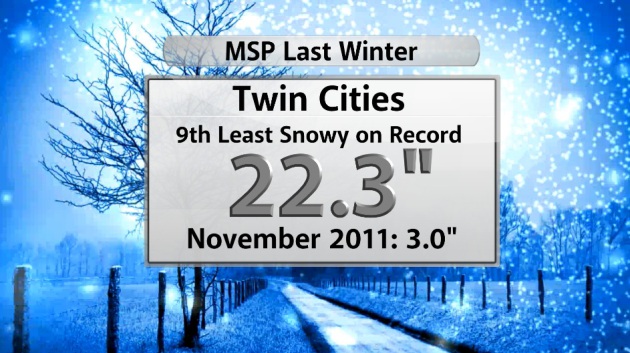
Even Worse Than Last Winter?
I didn't think it could be possible, but we're even doing worse than last year! Take a look. Last winter's 9th least snowy season on record (22.3" for the season) had 3.0" of snow in November of 2011.
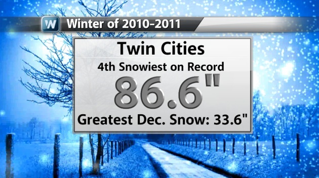
From Feast to Famine
I still can't believe that from the 2010-2011 winter to the 2011-2012 winter we had such a flip-flop. 88.6" of snow fell in the Twin Cities two winters ago (good enough for the 4th snowiest winter on record) and a year later we had the 9th least snowy winter on record.
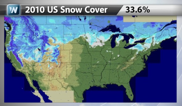
2010 US Snow Cover
The winter of 2010 was a big one for quite a few folks across the nation AND it started early. By this time two years ago, nearly one-third of the nation was covered in snow.
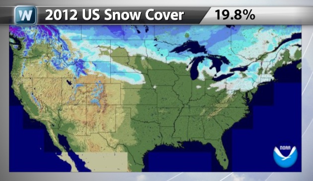
2012 US Snow Cover
So far this year, we're down about 10%-15% snow cover from this time 2 years ago. As of late November, 20% of the nation was covered in snow.
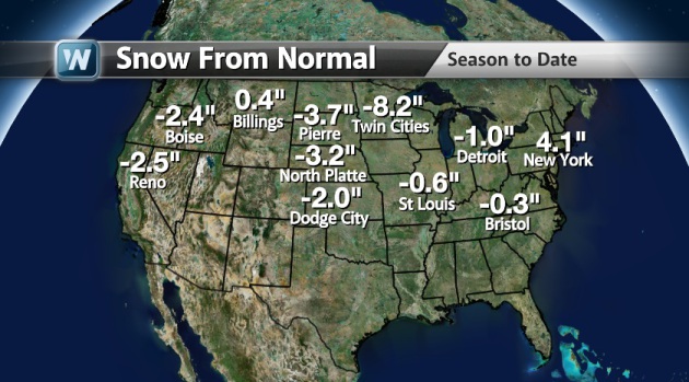
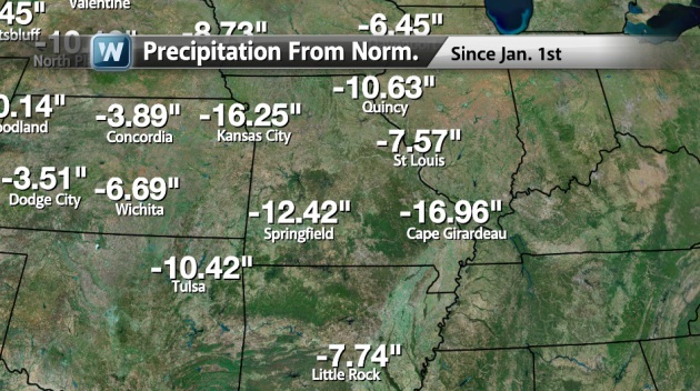
National Snow Deficit
There are a number of reporting stations that are noting deficits so far this season. Take a look at the numbers below.
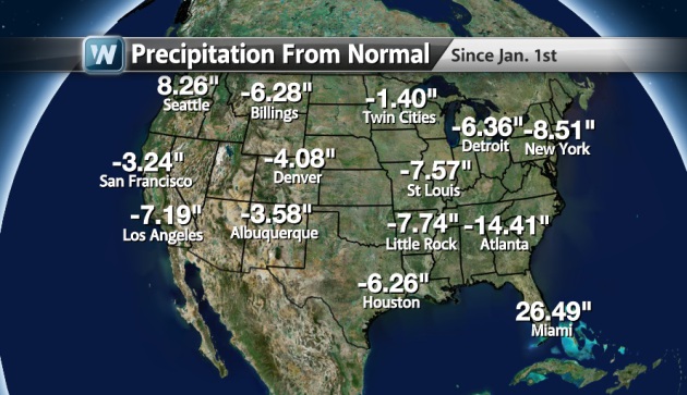
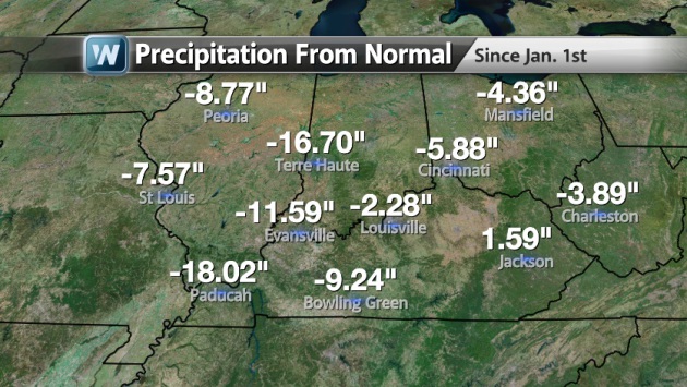
National Precipitation Deficit
This also coincides with the
national precipitation deficit, which is much more staggering than the
snow deficit. Unbelievably, every reporting station on the map
below (other than Seattle and Miami) are reporting below average
precipitation for the year.
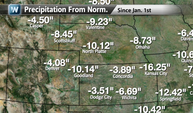
Closer Look at the Deficit
As we delve into the map here,
it reveals an even more grim scenario. Some spots in the middle part of
the country are a foot or more below normal precipitation for the year.
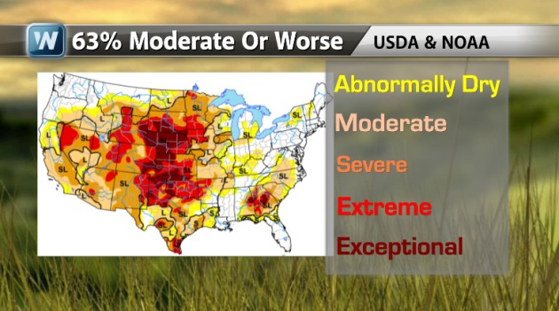
US Drought Update
The extensive drought of 2012
continues with nearly 63% of the nation under a moderate drought or
worse. The worst and most extensive part of the drought appears to be in
the Central Plains.
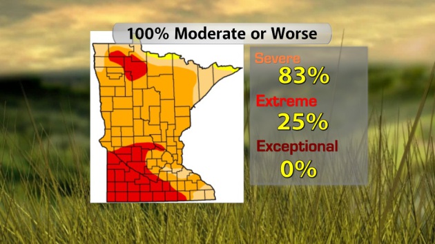
MN Drought
The drought across Minnesota isn't as bad as that in Nebraska, but we still have our fair share of problems. 100% of the state is considered to be in a moderate drought or worse with 25% of the state in an extreme drought.
The drought across Minnesota isn't as bad as that in Nebraska, but we still have our fair share of problems. 100% of the state is considered to be in a moderate drought or worse with 25% of the state in an extreme drought.
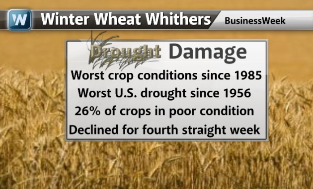
Winter Wheat Crop Whithers
According to Businessweek, the winter wheat crop isn't doing so hot. In fact these are the worst crop conditions since 1985.
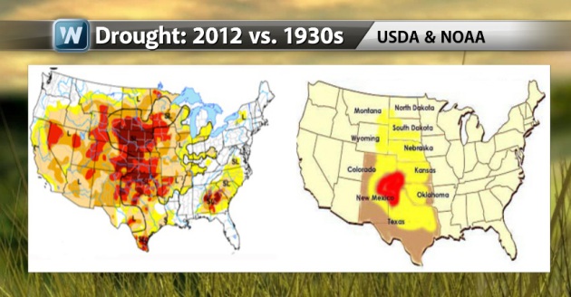
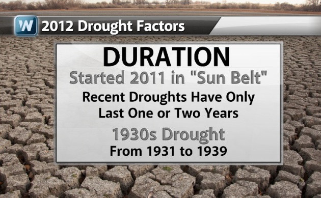
2012 Drought vs. the 1930s Drought
I thought this was
interesting... Comparing this year's drought to that of the 1930s, it
almost looks the same. Some of the same areas that were hit then are
being hit now.
"If the United States were
to experience a 1930s-style drought today, could it give us a second
Dust Bowl? Some of the driest and hottest conditions on record have
plagued parts of Texas, Oklahoma, Missouri, Georgia, and other states
over the last two years.
A number of factors—both meteorological and societal—would need
to conspire for the current event to resemble the all-out disaster of
the Dust Bowl. Yet a devastating outcome could emerge with a flavor all
its own."
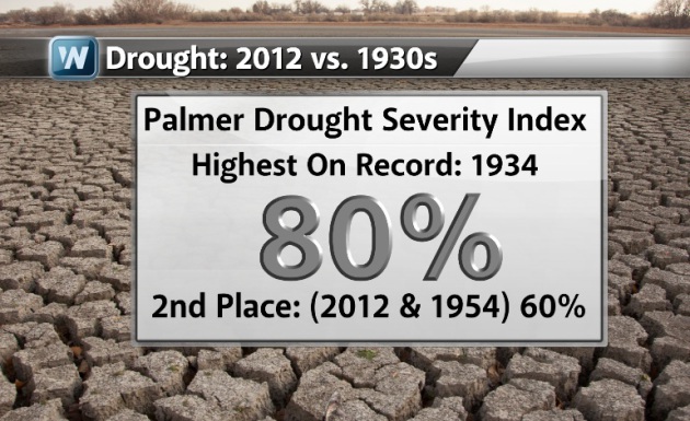
How They Compare
Back in the 1930s we didn't have the US Drought Monitor, so the next comparible thing is the Palmer Drought Severity Index
This index had 1934 as the most
extreme with the US at 80%... Not even close, but still relavant is the
2nd place 60% of the nation in 2012 and 1954.
"Since the Drought Monitor
didn’t exist in the 1930s, we need to use the venerable Palmer Drought
Severity Index to make an apples-to-apples comparison. (The PDSI is
among several factors that go into the Drought Monitor.) The highest
PDSI-based extent on record occurred in 1934, when 80% of the contiguous
United States was in some form of drought. Well back in second
place—with PDSI-based drought coverage peaking at roughly 60%—are 1954
and 2012."
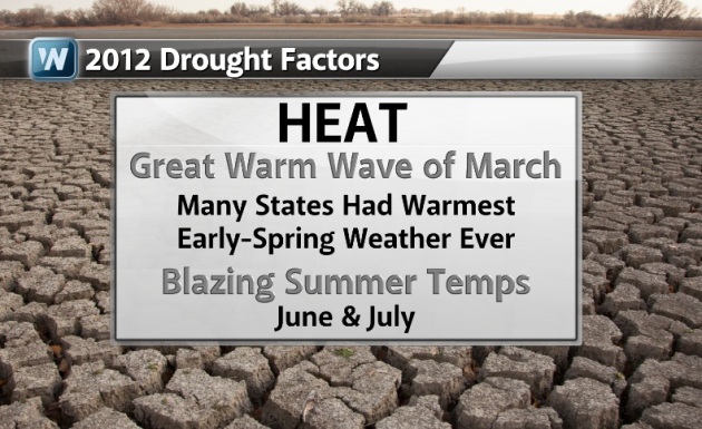
Contributing Factors to the 2012 Drought
HEAT: "The
Great Warm Wave of March 2012, which brought many states their
toastiest early-spring weather ever observed, provided an unusually
early kickoff to seasonal demand for water by fast-growing plants.
Blazing temperatures across the Midwest in early summer only made things
worse, pushing water stress to extreme levels as far northeast as
Indiana. According to Svoboda, “The heat in June and July really
exacerbated and accelerated the impacts this summer.”"
"DURATION. The current
drought doesn’t yet hold a candle to the Dust Bowl in terms of
longevity. After the 1920s, a decade of ample moisture and bountiful
wheat crops, the Great Plains fell into drought in 1931 and didn’t see a
major recovery until 1939. The 1950s brought another intense multiyear
drought that touched much of the nation."
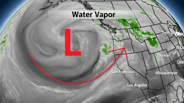
West Coast Storm
Look at this monster storm out
west! This behemoth will be responsible for flooding rains, damaging
wind gusts and heavy mountain snow through the weekend/early next week
for folks across the west. A piece of this storm looks to break off and
head inland over the weekend/early next week with rain, thunderstorms
and some snow by the first week of December for residence of the middle
part of the country.
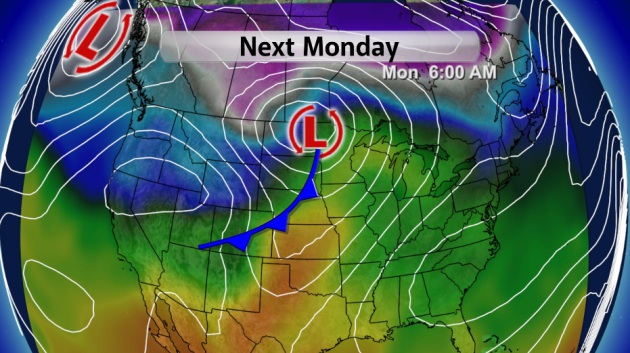
Next Monday
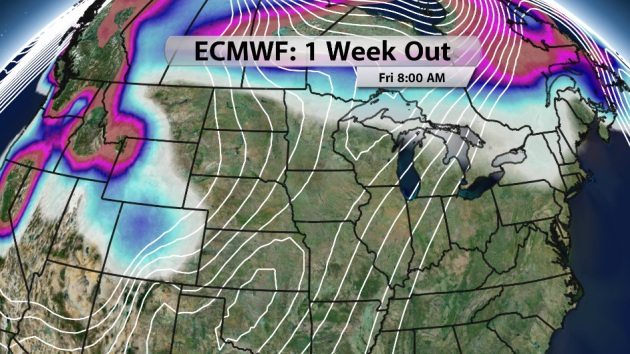
Snow in the Forecast?
Take a look ECMWF (European
model) over the next week. I've plotted accumulated snowfall through
next Friday and note the lack of colors in the middle part of the
country. According to this particular model, we stay mostly snow free
through the first part of December.
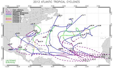
"In an average season (using 1981-2010 as a baseline), there are 12.1 named storms, 6.4 hurricanes, and 2.7 major hurricanes. This season ended up with 19 named storms, 10 of which became hurricanes, but just 1 of those became a major hurricane (defined as category 3 or higher on the Saffir-Simpson hurricane wind scale). The 19 named storms ties for the third greatest number of such storms in a season on record. Historically, only about 3 percent of seasons experience 19 or more named storms. As rare as this feat is, it was amazingly the third consecutive season to have 19 named storms!"
Read more from WashingtonPost.com HERE:
Thanks for checking in, don't forget to follow me on Twitter @TNelsonWNTV