28: average number of subzero nights every winter in the Twin Cities.
3: number of nights below zero so far this winter. There is a 1 in 3 chance of dipping below zero again by Friday morning.
12 subzero nights last winter in the metro area, as of February 5, 2011.
 5 days
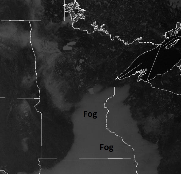
 of fog/stratus for much of Minnesota, more typical of late September or early October. Average number of days with 1/4 mile visibility or less in February:
1.4.
 10,000
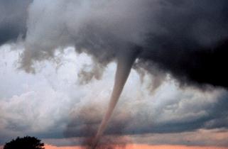
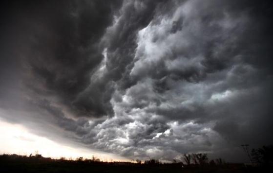
. Average number of severe storms reported across the USA during a typical year. Only 1 in 10 severe thunderstorms will ever go on to spin up a tornado.
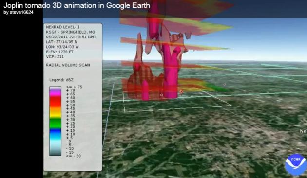
2011 Joplin tornado: "
The NWS found that many of that city’s residents required between two and nine “risk signals” (hearing a tornado siren, receiving a call from a relative, seeing darkening skies, etc.) before taking protective action, and that these signals partly depended on a person’s worldview, such as their past experience with tornadoes and false alarms." - Andrew Freedman from Climate Central. Details below. 3-D Joplin tornado simulation courtesy of NOAA.
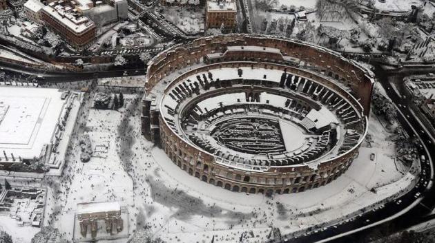
Rome's Snowy Coliseum. Photo courtesy of Germany's
Tagesschau and DPA.
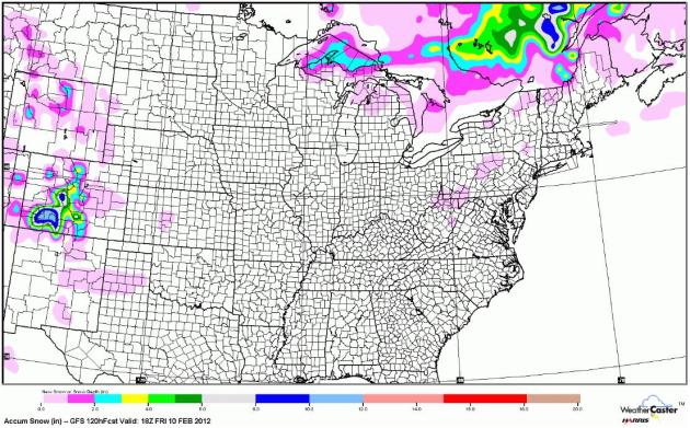 Minnesota's Snow Drought Lingers
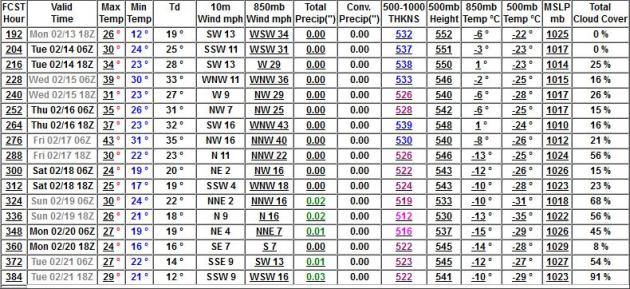
. The GFS forecast through midday Friday shows a total lack of any accumulating snow close to home, a couple inches over the U.P. of Michigan (lake effect) and snow showers for the Colorado Rockies. Otherwise...more of the same.
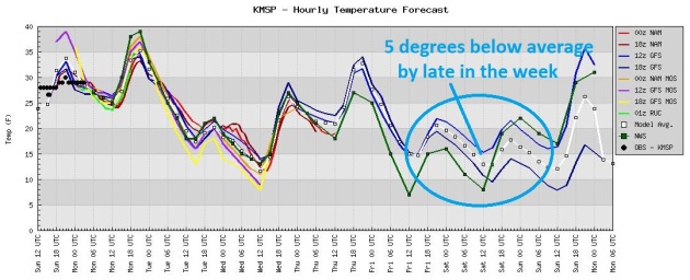 Late Week Cooling Trend
. Not sure I'd call this an "arctic blast", but it will feel more like February by Friday, with highs in the mid teens to near 20, a couple nights of single digit lows. We've seen 3 nights below zero so far this winter - not sure we'll see any more, although we may come very close Friday, again Saturday morning.
 Worst Of Winter Is Over.
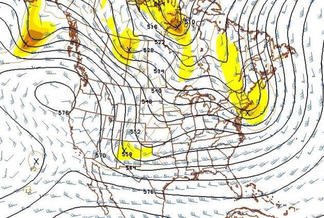
 I'm more confident than ever saying that. I said it about 2 weeks ago, and although I probably jumped the gun I'm feeling (a bit) more sure with each passing day. The GFS 500mb (18,000 foot) forecast for February 21 shows a west/northwest wind flow, a "modified Pacific flow", good for 30s, even a few 40s during the third week of February.
 February 13-21: Trending Milder Than Average
. No bitter air brewing for the 3rd week of February (in fact the coldest weather will probably come the end of this week, when temperatures fall a few degrees below average - still not sure we'll dip below zero though). And no, I still don't see any significant snow, ice or rain through the 21st day of February.
Storm Chaser Killed In Oklahoma Collision With Wrong-Way Driver.
MSNBC.com has more details on the tragic death of Andy Gabrielson on Saturday: "
Highway Patrol spokesman Lt. George Brown said a wrong-way driver of a white pickup truck traveling westbound struck Gabrielson's oft-seen black Chevrolet Tahoe head-on in the eastbound traffic lane. Another person was killed in the collision. Alcohol is suspected as a cause of the crash, the Highway Patrol said."
* you can see an online memorial to Andy's life and many accomplishments on
Facebook.
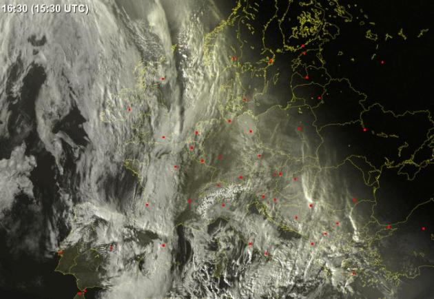
(London) Heathrow Airport Cancels 50 Per Cent Of Flights As Snow And Ice Blankets Britain.
The U.K. Telegraph has the story: "
More planes were grounded today at London's Heathrow airport following yesterday's adverse weather and the airport's decision to axe 30 per cent of its flights. The decision came as wintry showers ceased across the country and forecasters predicted dry conditions and a partial thaw. A spokesman for Heathrow said the move was designed to minimise disruption and in anticipation of possible freezing fog. While the runways, taxiways and stands have been cleared of snow, only 50 per cent of the 1,300 scheduled flights are now going ahead." Visible satellite image courtesy of
sat24.com.
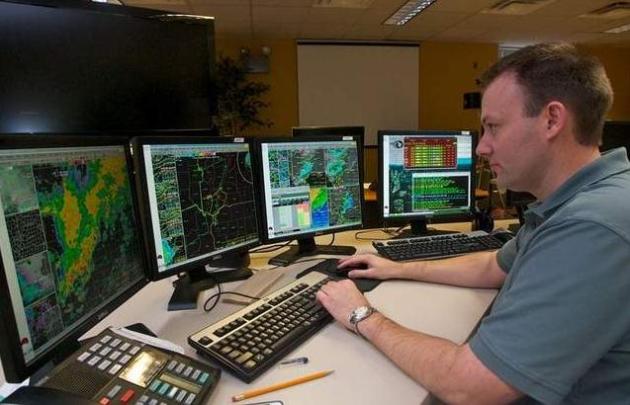
You, Too, Can Become A Storm Spotter. SKYWARN is always looking for volunteers willing to help them spot severe storms in real-time. Doppler radar is an amazing innnovation, but we still need (experts) on the ground, ready and able to confirm that rotation on Doppler is actually translating into a wall cloud, funnel or tornado. Here's more from
clarionledger.com: "
If there's a storm headed to town, Florence teen Wiley Smith stands ready to chase it. The home-schooled 15-year-old is a weather watcher who keeps his eye to the sky when black clouds obscure the horizon - and last April's devastating weather was no exception. "I was sitting in my front yard, looking straight up," he said of the mid-April storms that destroyed dozens of homes and businesses in the metro area and statewide. "I was ready." Officials with the National Weather Service in Flowood and Hinds County's Emergency Operations Center want both residents and emergency workers to recognize a bad storm and know what to do if they see one."
Photo credit above: "
National Weather Service meteorologist Brian Koeneke tracks weather conditions using radar Friday at the facility in Flowood. Free National Weather Service storm spotter courses will be offered Tuesday and March 22 in a partnership between the NWS and the Hinds County Emergency Operations Center. Photo: Melanie Thortis/Spcieal to the Clarion-Ledger."

Our Endless November
Welcome to The Winter That Wasn't. Like we never got past November, come to think of it.
There's an indentation in my office from where I've been banging my head against the wall.
Repeatedly.
We shouldn't have 5 days/row of thick fog and stratus in early February. An unusual spell of midwinter gray is a symptom of the odd, Memphis-like winter we're experiencing. Mild Pacific winds melted what little snow was on the ground, saturating the lowest levels of the atmosphere. A clear sky cooled temperatures to the dew point, resulting in stubborn fog - unable to burn off due to a low sun angle.
Statics show an average of 1.4 days/fog during the entire month of February. Then again you can prove anything with statistics.
Our snow drought drags on, but after a mild Monday it will start to feel like February later this week; we may even dip below zero for only the 4th time all winter.
Yesterday meteorologists were drooling over their laptops (electrocution risk) - maps looked ripe for significant snow around Feb. 20. No more. West/northwest winds aloft are too strong, weak clippers moving too fast to tap deep moisture from the Gulf. Our ho-hum winter drags on. Supernaturally quiet.
Climate Stories.....
Clear And Present Danger Not So Clear, Or Present. Here's a very
interesting post from Climate Central's Andrew Freedman: "
While there are no blaring climate change sirens to warn of global warming (now there’s an idea . . .), there is a steady drumbeat of risk signals that are only getting louder, from melting glaciers and Arctic sea ice to increasingly frequent and severe heavy rainstorms and heat waves. And despite scientists pointing to these warning signs for more than two decades, the climate issue remains politically polarized and perpetually on the back burner of the public policy agenda. After all, the only mention of “climate change” in President Obama’s State of the Union speech was to acknowledge the lack of agreement on the issue in Congress. Unlike with the Joplin tornado, the evolving signals of climate change are not ones that we’re particularly adept at recognizing or acting upon, since they involve massive changes over longer periods of time. This, combined with the fact that our brains are hard-wired to pay more attention to near-term threats than more distant ones, means that we may wait until it’s too late to run to the storm shelter."
"Global Warming Has Stopped". How To Fool People Using "Cherry-Picked" Climate Data.
Forbes.com has the story: "
The current favorite argument of those who argue that climate changes isn’t happening, or a problem, or worth dealing with, is that global warming has stopped. Therefore (they conclude) scientists must be wrong when they say that climate change is caused by humans, worsening, and ultimately a serious environmental problem that must be addressed by policy makers. The problem with this argument is that it is false: global warming has not stopped and those who repeat this claim over and over are either lying, ignorant, or exhibiting a blatant disregard for the truth. Here is a tiny sample of the false claims, gleaned from various blogs, comments to my previous Forbes posts, op-eds in the Wall Street Journal, news stories,nd statements from pundits who spread climate misinformation."
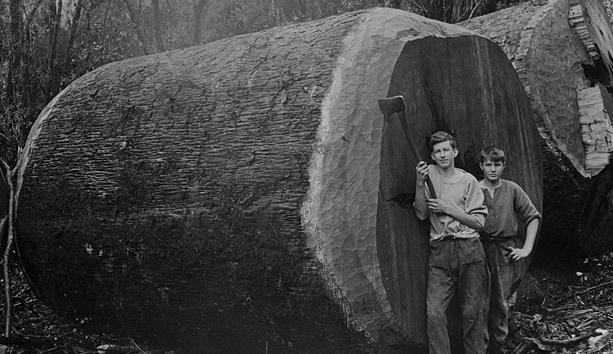
Forest Giants Forecast Trouble Ahead. The story from
stuff.co.nz: "
We're in for increasingly extreme weather, punctuated by intense floods and devastating droughts, according to research into kauri tree rings. An Auckland University study published in international journal Nature Climate Change today has found growth rings in the massive trees provide reliable records of historic El Nino and La Nina weather patterns – and show those patterns are becoming increasingly extreme. Lead researcher Anthony Fowler said that, during El Nino events, kauri grow rapidly and have wide tree rings, whereas during La Nina events they grow more slowly and have narrow rings. "Notably wide and narrow kauri tree rings have become more frequent as the world has warmed over the last few centuries."
Photo credit above: "
19th century forestry workers stand next to a felled kauri. Photo: Alexander Turnbull Library."
 What Global Warming Looks Like
. The story from Doug Craig at the
Record Searchlight (redding.com): "
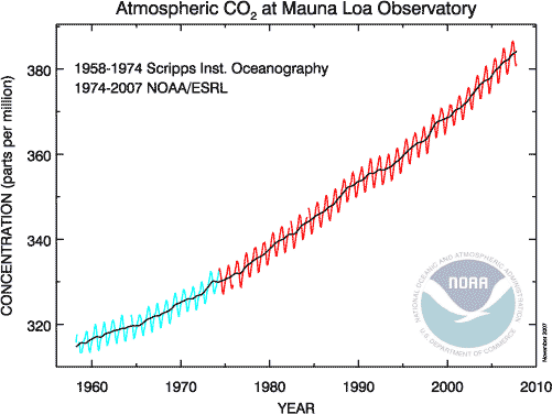
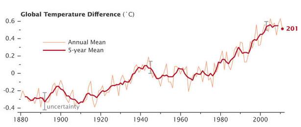
I am not a genius. I am not really all that smart about most stuff. After 25 years in private practice as a clinical psychologist, I think I know what I am doing in my field. Outside of that, I make very few claims. After about 30 months of blogging, Electric Ed suggested I put the graph (above) into my blog. I did not know how to do that. Thanks to Bruce Ross and my friend Mauro, it looks like it is actually down there. I am amazed. I don't know how I did this. I am not sure I will be able to do it again. But for now, this is a picture of global warming, according to NASA, Randy's favorite source on all things related to climate science. See how the red line goes up from the left to the right? You will notice it was climbing from when they started measuring in the late 1800s and leveled off from 1940 to 1980 due to soot and particulates in our atmosphere."
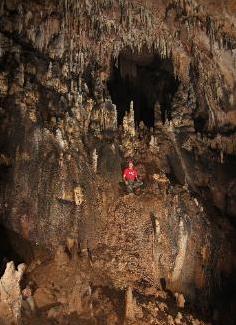
UNLV Researcher Finds Stalagmites May Reveal Clues To Climate Change. Details from
The Las Vegas Review-Journal: "
Across the sweep of a thousand years, as ancient cities bloomed and died in southern Mexico, the water in Juxtlahuaca Cave went drip, drip, drip. Now a UNLV researcher is using a stalagmite built by those droplets to chart 2,500 years of rainfall and draw new links between human history and climate change. The findings by professor Matthew Lachniet and his research team could help shed light on Nevada's climate over the past several thousand years and offer clues to how it might change in decades to come."
Photo credit above: "
Matthew Lachniet, an associate professor at UNLV, looks at rock formations in a cave in the Sierra Madre region of Mexico during a June 2011 trip. Lachniet says cave rock accurately records rainfall patterns through the centuries. His research might help explain the rise and fall of Mesoamerican civilizations."