3. We are picking up nearly 3 minutes of additional daylight every day now.
83 minutes of addiitonal daylight in the metro area since the Winter Solstice on December 21.
 54".
54". The 1981-2010 annual snowfall
normal for the Twin Cities is 54.0 inches, which is 7.4 inches more than the 120-year long-term average of 46.6 inches. Source:
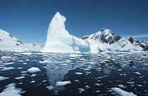
MN State Climate Office. Photo courtesy of NOAA.
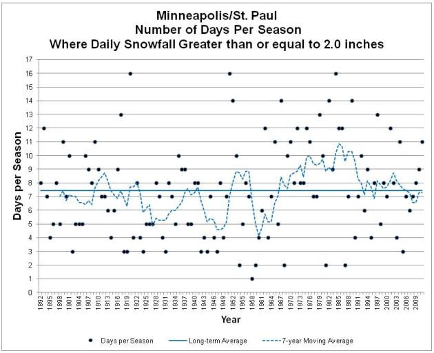
7.5. Number of daily 2"+ snowfalls the Twin Cities experiences every winter, on average. Source: MN State Climate Office. Details below.
1. Number of daily 2"+ snowfalls so far this winter (4.2" fell back on December 3, our biggest "storm" of the winter, so far).
 8
8 separate vehicles have fallen through thin ice in recent weeks around the metro area. Vehicles are now banned from area lakes, streams and ponds - it's still OK for walking, snowmobiles, etc - but exercise extreme caution.
 18"
18" the amount of snow that should fall between now and late April at KMSP, if this were an "average winter."
6-12" my prediction for how much additional snow may fall this winter season in Minneapolis/St. Paul, based on a lingering drought, weakening La Nina, and a mostly-positive phase of the AO and NAO.
25-30" my brash, delusional, semi-educated gut feel for snowfall totals in the Twin Cities this winter. A far cry from 86.6" last winter.
 90%
90% of the world's glaciers are in retreat. Source:
60 Minutes.
"
The total mass ice loss from Greenland, Antarctica and all Earth’s glaciers and ice caps between 2003 to 2010 was 1,000 cubic miles, about eight times the water volume of Lake Erie. “The total amount of ice lost to Earth’s oceans from 2003 to 2010 would cover the entire United States in about 1 and one-half feet of water,” said CU-Boulder physics Professor John Wahr, who helped lead the study. " - from a story below on global ice loss

 Twin Cities Snowfall, Month By Month.
 January is now our snowiest month of the year (in theory), with 13.5". Less falls in February, primarily because there are fewer days in the month. Average snowfall for March is 10.4", but a March snowfall is much different than a January snow - usually wet and slushy (and gone within 2 days, give or take). In theory, we should pick up another 18" of snow. Then again, this is proving to be anything but an "average winter." Source:
MSP Normals, a pdf provided by the MN State Climate Office.
"
Humor has a way of bringing people together. It unites people. In fact, I'm rather serious when I suggest that someone should plant a few whoopee cushions in the United Nations." - Ron Dentinger
 First Robin Sighting
. Thanks to the Missoula, Montana office of the National Weather Service for reminding us that spring is right around the corner! Truth: it's a big corner.
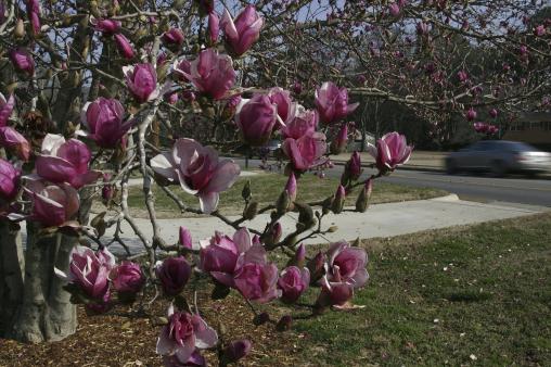 A Premature Spring
. Lawns are greeing up, many plants and flowers sprouting from Washington D.C. across much of the south. "
A Tulip tree on Drakes Ave. is in bloom Thursday, Feb. 9, 2012 in Huntsville, Ala.,, due to recent unseasonably warm weather in the Tennessee Valley. (AP Photo/The Huntsville Times,Robin Conn)."
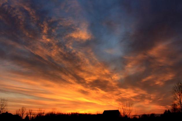 A Mango-Colored Sunset
. Meteoroogist Rob Koch filed this photo from Arizona.
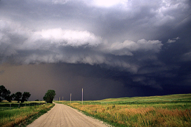
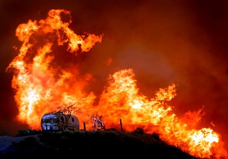 Dry Landscape Is Raising Fears Of A Fiery Spring
. This is a legitimate concern, considering the lack of snowcover, and what will almost certainly be one of the 3 driest Februaries on record. If we don't pick up a few significant storms in March (rain or snow) the risk of spring brushfires will be very high. Bill McAuliffe at the
Star Tribune reports: "
Dry foliage, dry soil, a dry atmosphere and a dry long-term weather outlook have fire officials in Minnesota bracing for what could be a dangerous fire season in the coming weeks. "It all adds up to the possibility of increased activity this spring," said Doug Miedtke, fire management specialist for the Interagency Fire Center in Grand Rapids, Minn. Without significant snow cover across much of the state, the Department of Natural Resources this week began requiring permits for open burning in all but about the northern fourth of Minnesota -- a "very unusual" situation for early February, Miedtke said. Permits generally aren't required where there is at least 3 inches of snow on the ground." File photo: AP.
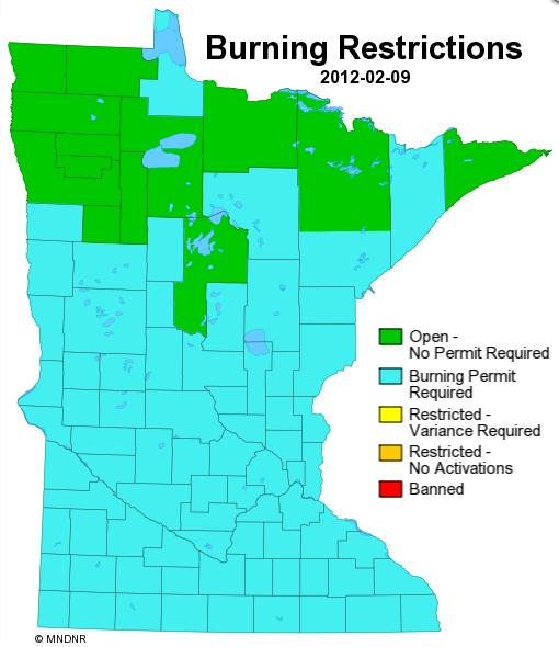 Burning Restrictions
. It's a bit strange to have burning restrictions on the 10th day of February, but unusually dry (sunny), snow-free weather, combined with gusty winds and low humidity levels have all increased the risk of brushfires. More from the Minnesota DNR
here.
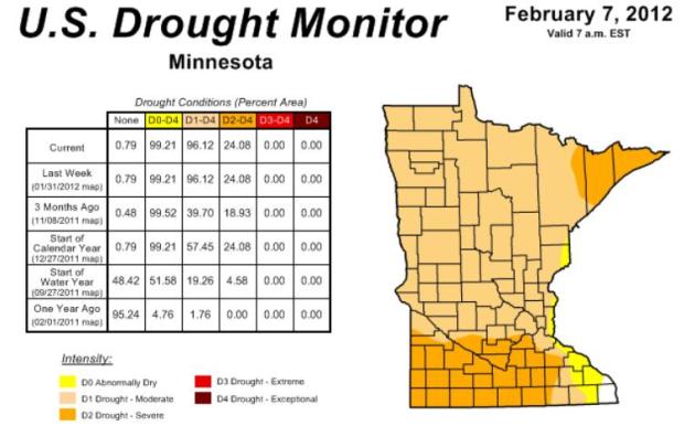 Update: Severe Drought For Roughly A Quarter Of Minnesota
. The latest
Drought Monitor shows that 99.21% of the state is "abnormally dry", 24.08% of the Gopher State is in a severe drought, continuing a dry trend since last autumn.
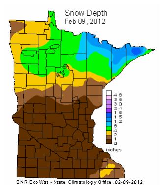 A Whole 'Lotta Brown
. The latest MN State Climate Office
snowcover map looks like something out of late October, or maybe the first week of November. But February 9th? Amazing how little snow is lurking out there right now.
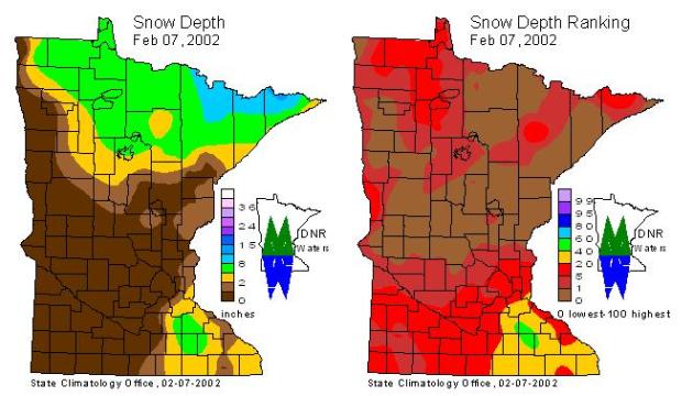
Least Snow On The Ground Since 2002? Pete Boulay at the Minnesota State Climate Office sent me
this link, showing snow on the ground on Feb. 7, 2002 - an eerie resemblance to the current map. He adds: "
One good winter that is an analog to this one is the balmy winter of 2001-02, but there was more snow. Also, the winter of 2005-06 comes to mind too."
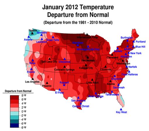
4th Warmest January On Record. Here's a good map showing the (amazing) temperature anomalies last month, as much as 8-12 degrees warmer than average from central Minnesota into North Dakota - but a vast chunk of America was milder, the result of a persistent Pacific wind flow aloft.
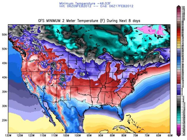
Coldest Temperatures Expected Over The Next 8 Days. The mercury drops close to zero Saturday morning, for only the 4th time all winter. Statistically we should have seen nearly 20 subzero nights as of February 10. So far this winter: 3 nights below zero, another night with a low of zero at KMSP. Subzero readings are likely from central Minnesota and northern Wisconsin into northern New England. Map courtesy of
policlimate.com.
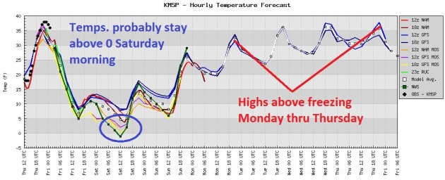 Subzero Saturday?
 Probably Not. We've picked up one hour and 23 minutes of additional daylight since December 21. The sun angle is higher, coupled with no snow on the ground and a light breeze...AND...the dreaded urban heat island (downtowns are usually 5-15 degrees warmer than outlying suburbs)
I'm predicting a low of +2 at KMSP Saturday morning. Close, and the suburbs will slip below zero, for only the 4th time all winter.
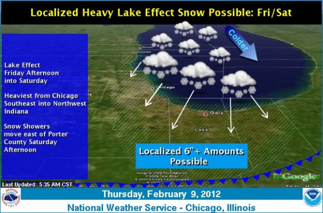
Lake Effect Snow Watch For Chicagoland. Is this the only way we can get snow, from lake effect? Seems like it. Again, this type of pattern is expected in November, when the differential between water temperatures and air temperatures are most extreme. But mid February? The Chicago area may pick up half a foot of lake-effect snow. Details from the
Chicago NWS office: "
A strong cold front will move southeast across the region Friday morning, bringing in much colder arctic air as we head into the weekend. As this cold air passes over the warmer waters of Lake Michigan, lake effect clouds and snow showers will develop, and these snow showers may become heavy Friday afternoon and evening. Locally heavy bands of lake effect snow will likely initially affect the Illinois shore and the IL/IN state line areas Friday afternoon and evening, before focusing more on northwest Indiana later Friday night and early Saturday as winds shift from the north-northeast to the north, and eventually northwest by midday Saturday."
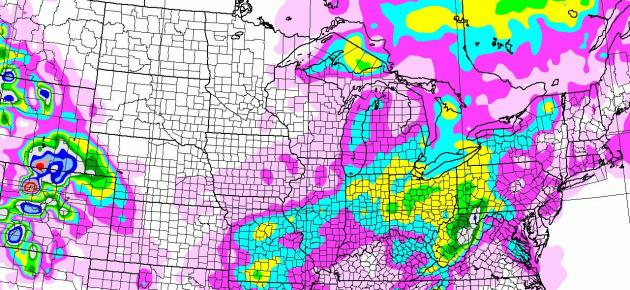
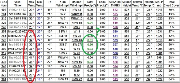
 Expected Snowfall Through Tuesday.
 We're beyond pathetic now in the snowfall department. 14.9" at MSP so far this winter? 5" less than Midland, Texas? That's just....wrong. Lake effect snow bands will set up behind today's cold front, sparking a few inches south/east of Chicago into much of Ohio and western Pennsylvania.
Fun With Statistics: An Average Of 7.5 Days Every Winter With 2" Or More. I stumbled upon
this graphic from the Minnesota State Climate Office, confirming my suspicions that we did, in fact, experience more snowy days during the 70s and early 80s. Since then the number of 2"+ snowfalls at KMSP has been on a downward trend. So far this winter: only one 2"+ snowfall in a given day (4.2" fell on December 3). Woo hoo!
 Tough Times For Snow Lovers
. At the rate we're going we may wind up with a 25" winter, unless we get socked in March, which is still possible, but would I wager $$ on that happening? Probably not. True, La Nina is finally breaking down, so (perhaps) the blocking pattern that has kept our winds aloft howling from the west, a mild, dry pattern for Minnesota (and much of the USA for that matter)
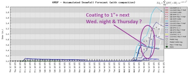
may mutate into a more variable pattern, one that can blow from the southwest from time to time. That's what we need to get significant snow (or rain): winds aloft blowing from Texas or New Mexico, allowing moisture from the Gulf of Mexico to stream northward. It has happened yet, but at some point the law of averages will catch up to us. In the short-term the next chance of a nuisance snowfall may come next Monday night or Wednesday, when it may be mild enough for a very light rain-snow mix.
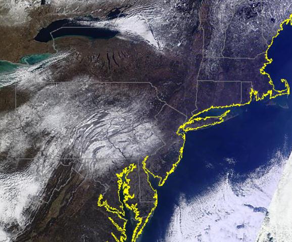
Evidence Of Thursday's Nuisance Snowfall. From NASA's high-resolution
MODIS satellite you can clearly see the 1-3" snow that fell on parts of Pennsylvania and western Maryland - the valleys and rivers really punch through, making it easier to distinguish snow on the ground from cloud cover (which has a flat/white appearance offshore).
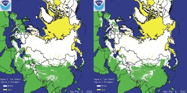
2011 2012
Eurasia Snowcover. Check out the difference in snowcover from year to year. This year snow is on the ground as far south as Africa. Map courtesy of
climate4you.com.
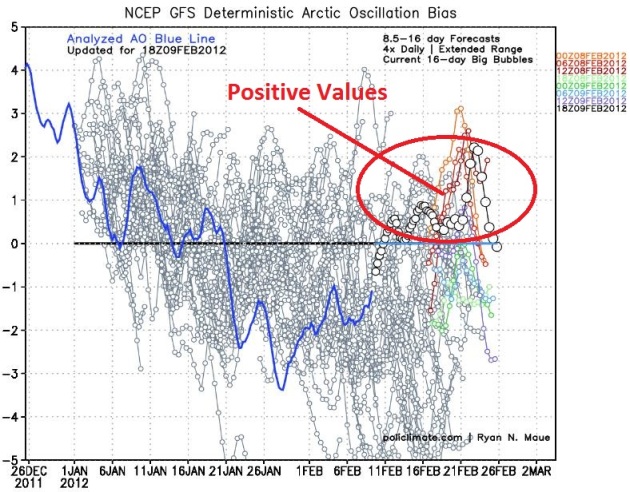 Arctic Oscillation: Trending Positive (Again).
 A strong positive AO (Arctic Oscillation) is thought to be at least partially responsible for our balmy winter. The more positive the AO, the stronger the westerly component to the jet stream, the harder it is for bitter air to penetrate into the lower 48 states. It's these intrusions of bitter air which often spin up significant snowstorms. No bitter cold? It becomes virtually impossible to create the conditions necessary for heavy snow. The AO is forecast to tick upward the third week of February, hinting at more unseasonably mild weather. Graph courtesy of
policlimate.com.
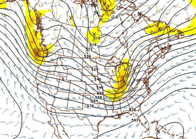 What February?
 The GFS 500 mb (18,000 foot)
wind forecast above is valid February 25, and it looks like something out of mid or late March, winds (once again) blowing from west to east, implying milder than normal weather for Minnesota and most of the USA. The only saving grace (and it's a stretch). The pattern has considerable energy; the jet forecast to blow at 80-120 mph. The faster the winds, the more unstable the pattern - the greater the odds of the jet stream "buckling", allowing cold air to surge south, carving out troughs of low pressure which are storm incubators. I don't see any major storm potential through late February. But don't write off March just yet. I
think I said the same thing 2 months ago, come to think of it.
 Last Half Of February: No Surprises
. Yes, we're due for a change in the weather, but I just don't see it. Highs reach the 30s, consistentl, from February 19 through the 25th - we may see one or two days of 40s. The only chance of precipitation comes around Feb. 21, but by then it may be warm enough for a rain-snow mix. Good grief.
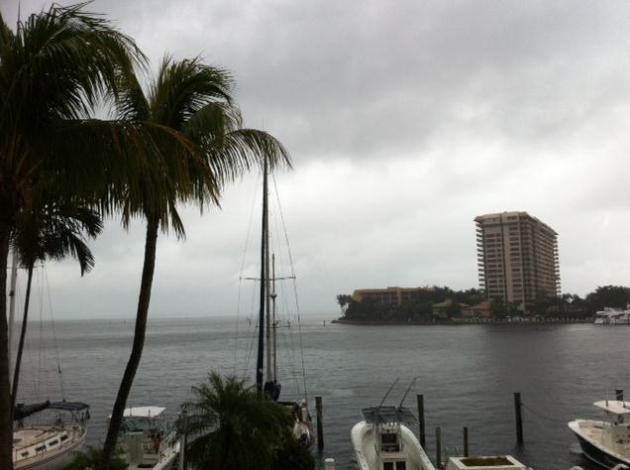
Miami (Weather) Vice. Meteorologist Bay Scroggins sent in this photo of a dreary, threatening sky in the Miami area, where it's been unusually wet in recent weeks.
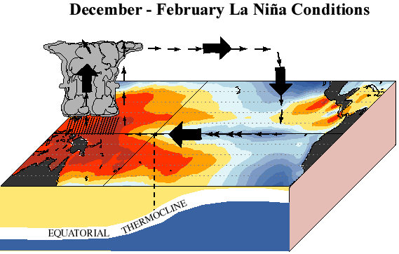
Good Riddance: La Nina Likely To Transition To ENSO-Neutral Conditions From March - May, 2012. NOAA's NCEP division has the latest on the cool phase of the Pacific, which is likely to become "neutral" in the coming months. With any luck that will mean an increase in precipitation across the Upper Midwest: "
A mature La Nina continued during January 2012, as below-average sea surface temepartures (SST) persisted across the equatorial Pacific Ocean. The weekly SST anomalies weakened in the far eastern Pacific, indicated by warming in the Nino 1+2 and Nino-3 regions. The ocean heat content (average temperature in the upper 300m of the ocean) anomalies also weakened slightly, but continued to reflect an extensive area of below-average subsurface tempeartures east of the Data Line." Photo credit:
themountainpulse.com.
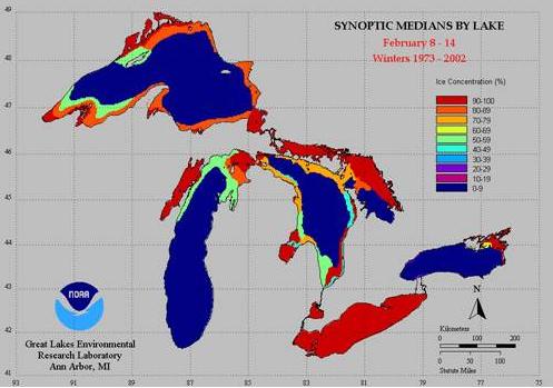
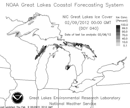
Normal Ice On February 9 Actual Ice (Feb. 9, 2012)
Great Lakes Ice: More Like Early November. Click
here to see average Great Lakes icecover on February 9; actual (2012) icecover is
here. Data courtesy of the Great Lakes Environmental Research Laboratory, a division of NOAA.
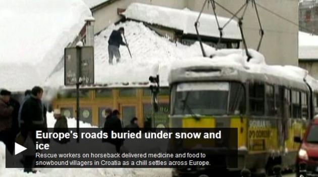
Ice-Breakers Have Been Called In To Clear The Danube River, Frozen Over In Europe's Big Chill. Some amazing details from
The Australian:
"ICE-BREAKERS have battled Europe's big chill as more than 170km of the Danube river froze over, and dozens died of cold on a continent gripped by some of the lowest temperatures in decades. The overall death toll from the cold snap that began 11 days ago edged past 400 while forecasters warned there would be no early let-up to the freezing weather. In Serbia, ice-breakers were summoned from Hungary in an attempt to keep the Danube flowing, while army demolition experts sought to dynamite ice barriers that threatened to provoke flooding on tributary rivers, including the Ibar."
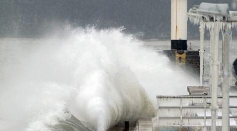
Winter "Hurricane" Causes Severe Damage On Bulgaria's Coast. The story from the
Sofia News Agency: "
The damage from Wednesday hurricane winds and 5-meter high sea waves on Bulgaria's Black Sea coast is estimated at BGN millions. The Deputy Regional Governor of Varna, Slavcho Slavov's probe in the nearby area has revealed huge losses. Eroded beach bars and restaurants; huge stones thrown from the sea on the sand beach and on the promenade, dead birds - this is the reported situation in Varna. Almost a third of the sand from the beach had been dragged into the sea, which is calmer Thursday."
Photo credit above: "
The stormy sea near Bulgaria's Black Sea capital Varna. Photo by BGNES."
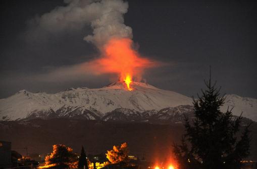
"Risk Of Lava Showers". Here's a tough way to beat the chill; live downwind of a major, erupting volcano. As if Italians don't have enough to worry about right now. "
Lava flows during an eruption of Mt. Etna volcano, near Catania, Sicily, in the early hours of Thursday, Feb. 9, 2012. (AP Photo/Carmelo Imbesi)."
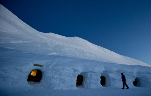 Photo Of The Day: German Igloos
. Now I've seen everything - evidence of the recent arctic front that has crippled much of Europe. "
This Wednesday, Feb. 8, 2012 photo shows a guest arrives at an igloo lodge sit on a bench near the Nebelhorn mountain in Oberstdorf, southern Germany. A village of ten igloos hosts up to 30 guests in the winter months and supplies them with warm blankets and sleeping bags, so that they can spend the night there. (AP Photo/dapd, Lukas Barth."
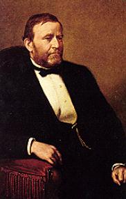
142 Year Anniversary Of The National Weather Service. NOAA's
Public Affairs Office reminds all of us why we celebrate February 9th. Hey, I don't take the National Weather Service for granted, and neither should you. We have the best service on the planet, and it didn't happen by accident: "
The National Weather Service has its beginnings in the early history of the United States. Weather has always been important to the citizenry of this country, and this was especially true during the 17th and 18th centuries. The beginning of the National Weather Service we know today started on February 9th, 1870, when President Ulysses S. Grant signed a joint resolution of Congress authorizing the Secretary of War to establish a national weather service. This resolution required the Secretary of War:
"to provide for taking meteorological observations at the military stations in the interior of the continent and at other points in the States and Territories...and for giving notice on the northern (Great) Lakes and on the seacoast by magnetic telegraph and marine signals, of the approach and force of storms."
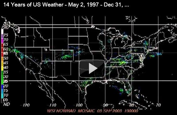
14 Years Of Weather In 30 Minutes. How bored are you? If you want to see Doppler radar going back to 1998, click
here, courtesy of digg.com.
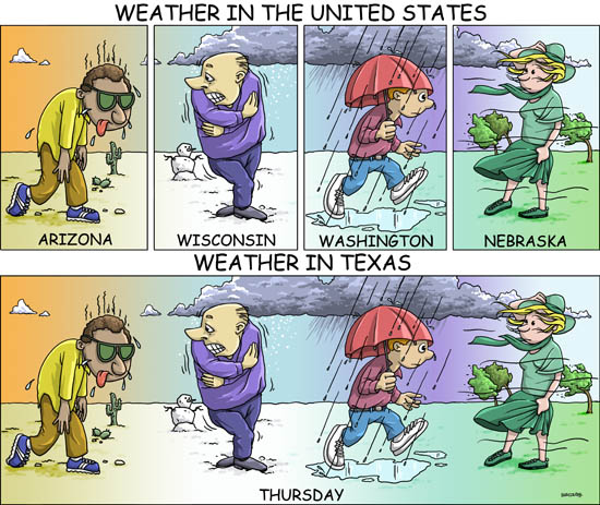
Weather In Texas (And Minnesota). Yep, this pretty much sums it up. Four seasons in one day (and that's a quiet day).
Does Your Family Have A Plan For Coping With Severe Weather? Some timely advice in an editorial at the
Times Herald: "
This is Severe Weather Awareness Week (Georgia), and The Newnan Times-Herald has been publishing a series of stories about how we can prepare for the likelihood of bad weather. We are in the middle of a mild winter, and while we have missed snow and icy conditions so far this winter, we have already had a tornado do minimal damage in the southern part of Coweta County. As spring approaches, the dreaded storm season will arrive, which often brings deadly tornadoes, violent thunderstorms with potentially deadly lightning, and the possibility of dangerous flooding."
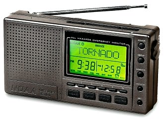
NOAA Weather Radio Could Save Your Life. I couldn't agree more. Every home, business, hospital and nursing home/retirement center should have one. It's the ONLY device that will set off a (loud) audible alarm at 2 am, if a tornado is heading toward your location. The newest versions have "SAME Technology", which allows you to program only your county - so the thing won't be going off night and day and making everyone crazy.
Fox2 Now in St. Louis has more: "
The St. Louis area has experienced plenty of severe weather and tornadoes the past several years. These storms have hit in every season and at all hours of the day and night. While Fox 2 is your best source for up to the minute weather coverage, you may not always be around your TV...and what about when you're asleep at night?"
iPad 3 Rumors Hint At Larger Battery, Retina Display. More from
gizmag.com: "
Leaked iPad parts suggest that the iPad 3 will have a larger battery, an updated camera, and a Retina display all in the same form-factor as the iPad 2. RepairLabs got its hands on what are said to be insider photos of the the rear-shell of the device, which seems to point to a few changes coming to the next generation of the tablet. The mounts for the iPad's logic board are different and the casing also has space for a larger battery, plus a slightly different camera. The mount for the display is also slightly different, indicating we'll see a change (and hopefully an upgrade) on that front as well."
Recycling Your Gadgets And E-Waste. I don't know about you, but I have a few desk drawers full of old, discarded (6 month old) stuff. Resist the urge to just toss it in the trash. Consider a donation, but if you want to throw it away, recycling is the way to go.
Rethinkrecycling.org has some good advice: "
Electronic waste, or e-waste, is any waste that has a circuit board or a cathode ray tube (CRT). This includes products such as:
- Televisions
- Computers: central processing units (CPUs), monitors, laptops
- Computer keyboards, speakers, printers, and other peripherals
- VCRs and DVD players
- Fax machines
- Game consoles
- Media players
- Other audio, video and telecommunication equipment (such as stereos, VCRs and cell phones)
Electronic products containing a cathode ray tube (such as TVs and computer monitors) cannot be placed in the garbage (Minnesota State Statute 115A.9565). The solution? Recycle your electronics."
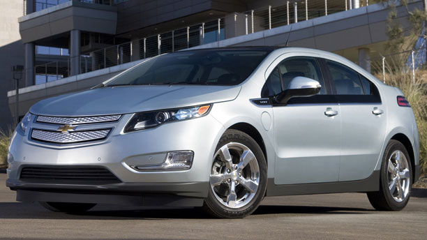
Myths And Facts About Electric Cars. The post from
Media Matters: "
As automakers are starting to bring electric vehicle (EV) technology into the mainstream, conservative media outlets have repeatedly misled consumers about electric cars by trying to paint them as environmentally harmful and unsafe, among other false claims."
Some media outlets are campaigning against electric cars by claiming:
Denying That EVs Reduce Carbon Dioxide Emissions
Downplaying EV Sales
Misleading About EV Distance Range
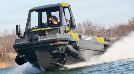
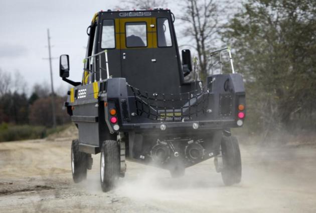
Gibbs Unveils Two New "Amphitrucks". Wonder if I'll see one of these on 'Tonka this summer?
Gizmag.com has the details: "
The folks at Detroit's Gibbs Technologies are no strangers to aquatic vehicles. In the past several years, they have brought us the zippy Aquada sports car, the Quadski ATV/personal watercraft hybrid, and the four-wheel-drive Humdinga SUV concept. Yesterday, they announced the addition of another two vehicles to their fleet - the Phibian and Humdinga II high-speed Amphitrucks. The mostly carbon fiber-constructed 4WD Phibian is capable of highway speeds when traveling on land, thanks to its twin turbo diesel engines - looking like it does, it would also presumably be capable of turning quite a few heads while heading down the road."
"
You can learn many things from children. How much patience you have, for instance." - Franklin P. Jones
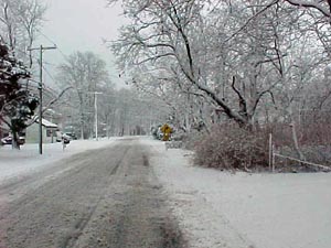
Where's My Coat?
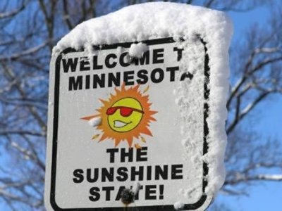
Brush the cobwebs off your favorite coat or parka; you'll need it through Saturday. Our light-jacket winter has grown some teeth - temperatures may dip below zero tomorrow morning, for only the 4th time all winter. During an average winter (whatever that is) we enjoy 28 nights of negative numbers. There's a stat you won't hear from the local Chamber of Commerce anytime soon.
According to Pete Boulay at the MN State Climate Office December 1 through the 1st week of February was the warmest since 1877-78, the mythic "Year Without A Winter" in Minnesota. Snow lovers are in a funk, but the USA is saving billions on snow removal and heating costs. We've saved 20% on our heating bills since late summer.
During a typical winter we see 7 daily snowfalls of 2 inches or more. So far this winter: ONE two-incher (4.2" on December 3). That was our biggest "storm" of winter, so far. Pathetic. Glorious. Disgusting. Dream-like. Few of us are on the fence. It's a love-it-or-hate-it winter.
We thaw into the 30s again next week; the maps look a little bit better for snow the last week of February. No, I haven't given up. Expect 48 hours of mild pain; this is the coldest weather of February.
"
There is a suffiency in the world for man's need but not for man's greed." - Mohandas K. Gandhi
Climate Stories...
John Abraham Takes A Stand. Full disclosure: John is a friend and a colleague. St. Thomas and the state of Minnesota are lucky to have him here. He's standing up to ignorance, bullying and hypocrisy, as reported in
St. Thomas Magazine: "
Dr. John Abraham and his wife, Molly, packed up their kids and headed to Disneyland in July 2010 for the family’s first real vacation. Four-year-old Olivia and 3-year-old Lilith fell in love with Disney’s dazzling King Arthur Carousel. They didn’t ride it once or twice, they went on it seven times. While his kids were having the time of their lives, the St. Thomas associate professor of mechanical engineering unfortunately had other things on his mind. Between carousel rides, Abraham kept checking his cell phone for messages. Headlines like this one - not only in the United States but in Europe, Australia and New Zealand - explain why: "The Monckton Files: Bombshell!!! John Abraham to be Sued!!!" Abraham had tangled with Scotland’s Christopher Monckton, one of the world’s most prominent global-warming skeptics and a sought-after speaker by the kind of organizations that share his skepticism."
 Global Warming: CU-Led Study Pinpoints Earth's Ice Loss
. The story from the
Summit County Citizens Voice: "
Earth’s glaciers and ice caps outside of the regions of Greenland and Antarctica are shedding about 150 billion tons of ice annually, according to a new study led by the University of Colorado Boulder. The total mass ice loss from Greenland, Antarctica and all Earth’s glaciers and ice caps between 2003 to 2010 was 1,000 cubic miles, about eight times the water volume of Lake Erie. “The total amount of ice lost to Earth’s oceans from 2003 to 2010 would cover the entire United States in about 1 and one-half feet of water,” said CU-Boulder physics Professor John Wahr, who helped lead the study."
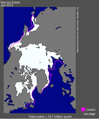
Image caption above: "
Arctic sea ice extent is below average in early February, according to the National Snow and Ice Data Center."
The Business Of Risk - Insuring Against Climate Change. The story from
desmogblog.com: "
When it comes to assessing risk, the insurance industry is one of the leaders in the field. Whether it is health insurance, car insurance, or homeowner’s insurance, the industry is forced to analyze every possible scenario for a given person or structure, and impose a fee based on the likelihood of events for the situation. So when an entire industry that bases their profitability on reducing risk starts factoring climate change into their equations, it's probably a good idea to pay attention. Earlier this month, insurance commissioners in three separate U.S. states began mandating that insurance providers include the risk of climate change disasters in their risk equations, and develop and disclose their plans to deal with climate-related catastrophes. These plans will be laid out in surveys that insurance companies will provide to insurance commissioners in their respective states."
Challenge Of Making Climate Change News Sounds "Newsy".
OPB News has the story: "
Dog bites man: news or not? If you’re a journalist, you don’t even need to think about it. The phrase is our professional shorthand for an idea that hardly qualifies as news, that it's not out of the ordinary. Man bites dog (goes the second half of the cliché), now that’s news! It’s not an ironclad rule, though: if the dog bites the man after winning first place at the Westminster Dog Show, or if a marauding dog is biting its way through a terrified neighborhood, or if First Dog Bo bites Sasha or Malia — that’s news, too. So when January 2012 was officially declared America’s fourth warmest January on record yesterday by the National Oceanic and Atmospheric Administration (NOAA), was that news or not? Here at Climate Central, we thought it was. But then, we would."
U.S. Indicts Romanian Over NASA Climate Change Hack. An update from
ZDnet.com: "
US authorities have charged a Romanian hacker with causing massive damage to NASA equipment in an attack that took place just over a year ago. 25-year-old Robert Butyka, whose handle was 'Iceman', already received a three-year sentence and seven years' probation last month in Romania, over the same incident. However, on Tuesday a federal grand jury in the US said Butyka should face trial there too. "The one-count indictment returned by the grand jury yesterday charges Butyka with unauthorised impairment of a protected computer," the US Department of Justice (DoJ) said in a statement on Wednesday. "If he is convicted of the computer hacking offense, Butyka would face a statutory maximum sentence of 10 years in a United States prison."
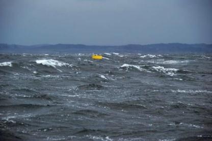
Feds Look To The Oceans For Clean Energy As Scientists Debate Wave Power Potential. The story in the
Monterey County Weekly: "
Offshore oil drilling doesn’t stand much of a chance in the protected waters of Monterey Bay. But as the U.S. Department of Energy eyes the sea for renewable energy, local shores are strong contenders.
Apart from Alaska, California’s Central Coast has the nation’s highest potential for wave power, according to a report by Palo Alto-based Electric Power Research Institute. EPRI project manager Paul Jacobson estimates the Central Coast’s outer continental shelf packs about 21 gigawatts per year in available wave energy, the rough equivalent of 21 nuclear power plants."
Photo caption above: "
Good Buoy: MBARI engineer Andrew Hamilton invented this buoy with small-scale power potential. It converts wave energy to electricity stored in a battery, which can be used to power oceanographic equipment. Francois Cazenave, MBARI."
