36.7" average snowfall for KMSP, to date.
61.1" amount of snow that had fallen last year, as of February 12. Source: NOAA.
10,000 new baby-boomers retire every day in the USA.
100,000 heartbeats/day. The average number of heartbeats for an adult. Female hearts beat slightly faster than male hearts. Go figure.
Sunday Florida Chill:
24 F. low at Jacksonville, Florida Sunday morning, breaking the old record of 26, set in 1981.
30 F. low at Daytona Beach, Florida Sunday morning. That ties the old record of 30 set in 1955.
* this is why, if you want to avoid chilly, frosty weather in January and February, you need to consider far southern Florida: Ft. Myers to West Palm, Boca Raton and the Miami area. You'd be amazed how chilly it can get this time of year, especially over the Florida Panhandle.

"Unpredictable weather is harder on plants than consistent cold and snow. This winter will be tough on plants not just because they're unprotected but because they went into dormancy stressed from lack of moisture and the drought looks likely to continue into spring. Uneven temperatures are especially hard on shallow-rooted plants and plants that aren't well established. Frost-thaw cycles can heave plants right up out of the ground, roots and all." - from an article below at twincities.com. Photo credit here.
"Only the paranoid survive." Andy Grove, former CEO of Intel.
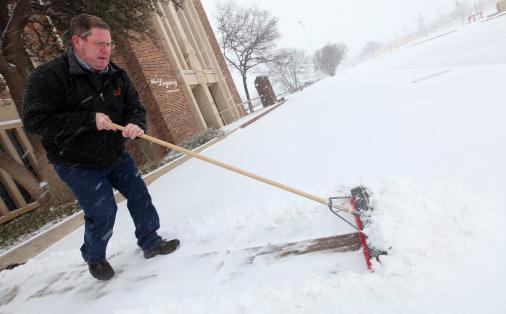
Upside-Down Weather Map. At least it's snowing somewhere, but Texas? Amarillo picked up a few inches of snow, laced with ice. I-40 had to be shut down for a time due to drifting and treacherous conditions. More details: "Don Bewley works to clear a sidewalk of snow fall in Lubbock, Texas, Sunday, Feb. 12, 2012. A winter weather system brought snowfall and ice to a large portion of West Texas. (AP Photo/Lubbock Avalanche-Journal, Zach Long)."
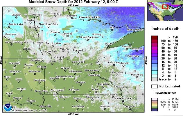
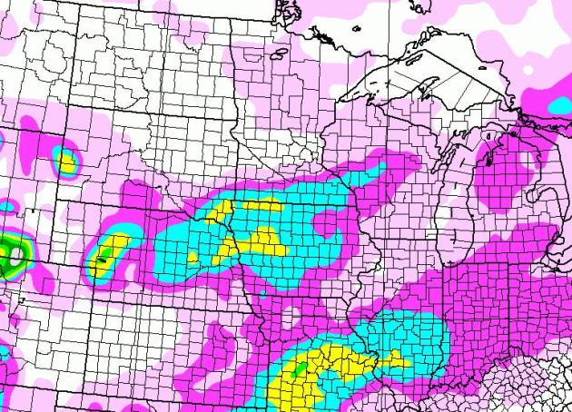
Where's The Snow? Good question. I still find it baffling and mildly offensive that Midland, Texas has picked up nearly 5" more snow than the Twin Cities this winter. The latest NOAA snowcover map shows virtually no snow on the ground over the southern half of Minnesota, 4-8" over far northern counties, with some 16-20" amounts (mostly lake effect and clippers) in the Boundary Waters.
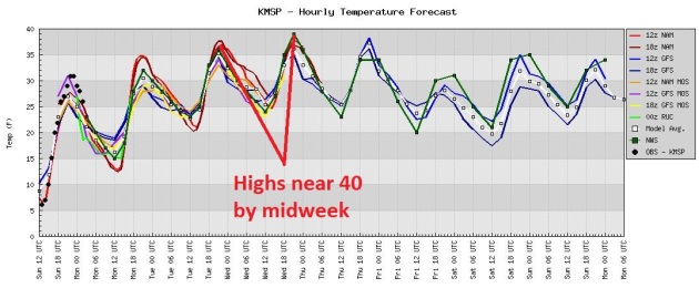
More Hints Of March. All the models warm us up a few more degrees this week, highs consistently in the 35-40 F. range from today through Thursday, followed by a slight cooling trend by the weekend. The European (ECMWF) model brings some low to mid 40s into town early next week.
The Story Of Our "Winter": Storms Detour South of Minnesota. Parts of Iowa may pick up a couple (slushy) inches of snow today, again Thursday, with a coating of slush into Albert Lea, Austin and Winona, little more than flurries in the immediate metro area.
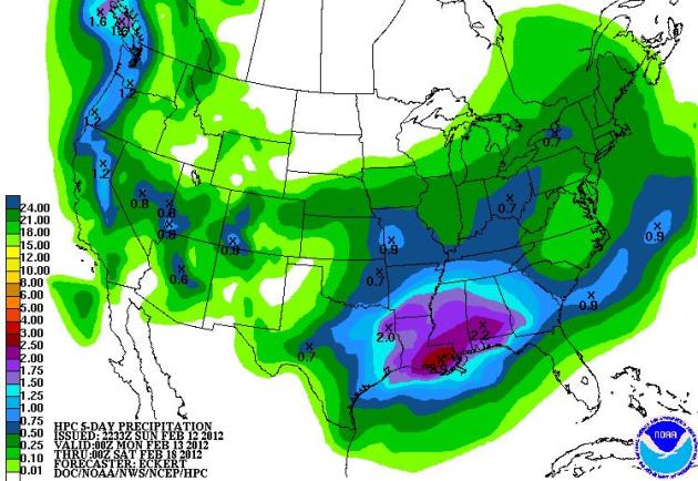
The Week Ahead. NOAA's QPF precipitation forecast hints at some 2-3" rains from New Orleans to Mobile and southern Alabama, a soggy spell for much of the Mid South, Gulf Coast and west coast.
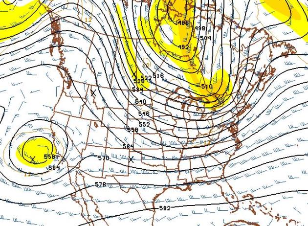
Chilly End To February? My confidence level is low, because the models keep flip-flopping, which is to be expected when upper-level jet stream winds are this strong, creating a very unstable pattern, one that makes a 1-2 week forecast more problematic than usual. The GFS forecast for February 28 (above) shows a strong northwest flow, which implies at least a few days with highs in the 20s. That's 20s above zero, btw.
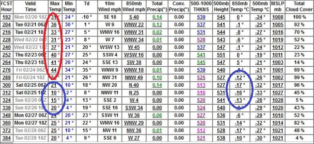
Premature To Pack Away The Coats & Heavy Jackets. Yes, I suspect the worst of winter is behind us now, but there's little doubt we'll see more (significant) cold frontal passages. The GFS keeps us in the 30s and low 40s through the end of next week, followed by a quick 2-3 day cold spell from Feb 25-27. I still don't see any significant storms (of any flavor) looking out 2 weeks. The drought is going to get worse before conditions (hopefully) improve later in 2012.
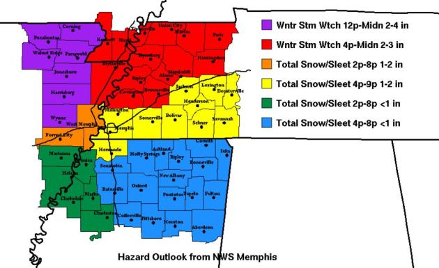
Ski Memphis. Want some snow? Head down to Memphis, where 1-2" may fall, as much as 2-4" just north of the Memphis area. Map courtesy of the NWS/Memphis and yfrog.
Wary Of Tornadoes, Wisconsin Firms Installing, Selling Shelters. The concept of "safe rooms" is catching on - far cheaper than excavating to put in a basement shelter. The Milwaukee Journal Sentinel has the story: "When a company safety director visited the Green Bay Packaging, Inc. plant near Kansas City, Mo., last summer, workers told him they needed a storm shelter. Jeff Burrell, the plant's general manager, recalls the conversation. "What do we do in a storm?" employees asked. "We don't have any place to go." Just before that meeting, a tornado had pulverized a huge swath of Joplin, Mo., killing more than 150. "People were aware of what had just happened in Joplin," Burrell said. "It was very, very much on everybody's mind. It still is. " "We were sitting here saying, 'You know, it could have been us. And we have no place to run,' " Burrell said. Crews finished installing a tornado shelter at Green Bay Packaging's Kansas City plant last month."
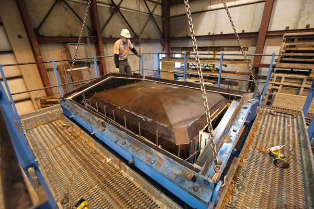
Photo credit above: "Deke Mader checks the fit of the outer jacket of the form as it's lowered over the inner core and rebar cage last week before the concrete is poured at Crest PreCast in La Crescent, Minn. Crest also has added operations in Barneveld, which was hit by a deadly tornado in 1984."
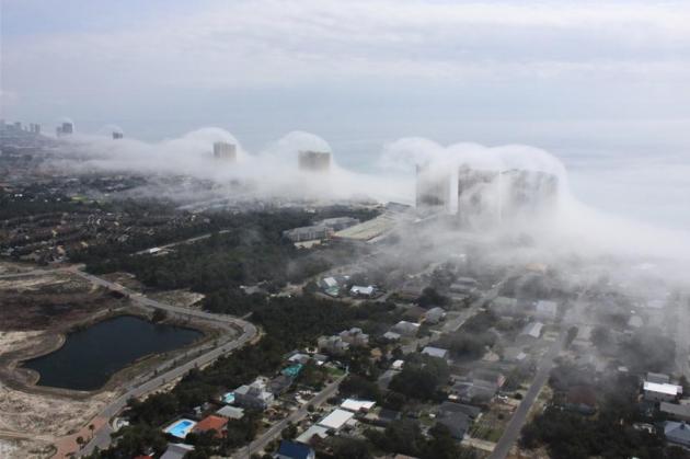
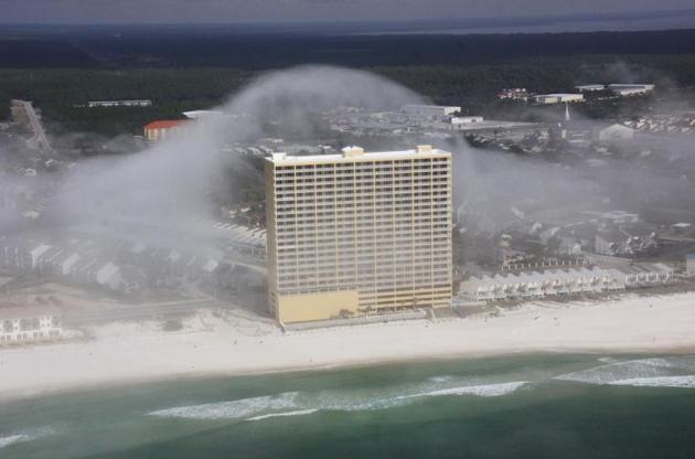
"I wouldn't call it a "cloud tsunami." The term tsunami implies a natural disaster. The event, while it can form quickly, moves gently and slowly. It isn't something that happens with more than a gentle breeze."
Photo credit above: "Panama City Beach, Florida -- Fog rolls up along the shore of Panama City Beach, Florida on Feb. 5th, 2012. JR Hott / Panhandle Helicopter."
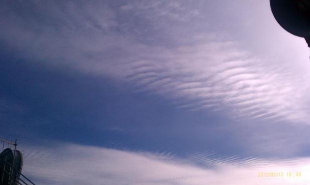
Wave Clouds. From the Medford, Oregon office of the National Weather Service: "Altocumulus undulatus over the Rogue Valley this morning. This type of cloud indicates increasing moisture and wind shear aloft. It is common ahead of approaching frontal systems. Can also make for a bumpy airplane ride."

Apple Suppliers Offer Clues About iTV. Here's an interesting story from seekingalpha.com: "Dear Siri, will Apple (AAPL) release an iTV this year? Unfortunately, Siri isn't talking. She either doesn't know, or isn't willing to tell us what changes are coming to the iPad 3, rumored to be launched in March, or the iTV, rumored for this fall. Since Siri isn't talking, I searched for clues in the earnings transcripts of Apple's supply chain. Apple's super secretive nature hasn't changed with the death of Steve Jobs. So, as expected, no supplier referenced Apple directly. However, each had interesting takes on their business, which sheds light on Apple's, and other OEMs', path. Across the various suppliers, a clear theme is apparent. They're already knee deep in building out product lines in support of integrated at-home, connected devices designed for delivering and sharing video, audio and data. Such features scream smart television, the centerpiece of home entertainment."


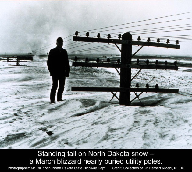
Once Upon A (Snowy) Time. Remember when it really snowed? No, I don't either. Last winter was a little like winning the Lotto for beleagured snow-lovers, but I can't remember a winter like the one pictured above. Thanks to Bill Koch at the North Dakota State Highway Depoartment and the collection of Dr. Herbert Kroehl, NGDC.
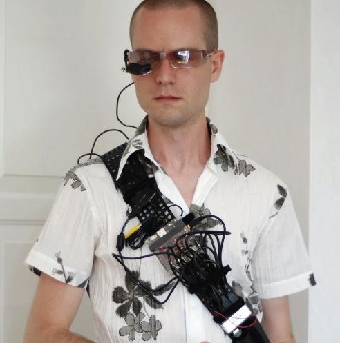
A Reluctant Cyborg
"Computing is not about computers any more. It is about living," wrote futurist Nicholas Negroponte. Computers were going to set us free, do the mundane, menial work; free us all up to pursue our passions. Remember? Instead we're all connected, nearly 24/7 - our smartphones almost extensions of our bodies. "Paul, I e-mailed you 10 minutes ago. Where are you?" Always-on. Anytime. Anywhere. Now there's WIFI on cruise ships! My iPhone works in iEurope! Not sure whether to applaud or weep. Experts tell us we need true downtime to recharge our batteries. We need quiet time to be truly creative.
Look, I'm no Tech-Luddite; I geek out on new gadgets (productivity devices) and I have no interest in returning to the analog 1970s. But I worry about my lazy brain: addicted to Google, GPS and nav systems. We have the world at our fingertips and hundreds of Facebook friends, yet how many of us (really) know our neighbors? Guilty as charged.
Without computers we wouldn't be able to predict weather much beyond 24 hours. But computers are only as smart as the people who program the computers. We use advanced mathematical equations to simulate how the atmosphere should work, but these equations are only rough approximations to how things work in reality. They're getting better (long range accuracy improves about 1% every year), but junk in - junk out. That, and it's impossible to get a perfectly accurate snapshot of the atmosphere, worldwide. Little imperfections at "initialization" blow up into bombs within 1-2 weeks. That's why the weather forecast isn't more accurate. The computer models are off, slightly, and those bugs grow with time. It's humbling, and more than a little reasurring, to know that there will never be such a thing as a "perfect weather forecast". Sadly, that concept is an oxymoron.
Those (imperfect) models whisk storms to our south this week (slushy inch over southern MN today). Highs hit 40 by midweek, still no big storms in sight.
Cooler air returns by late February, but we may have seen our last subzero low of winter.
* photo above courtesy of Sigalon's Mobile Soup.
"Three things are certain: death, taxes, and lost data. Guess which has occurred." - David Dixon, from a 1998 salon.com contest.

"Weather and climate are flip sides of the same coin." - anonymous.
Climate Stories....
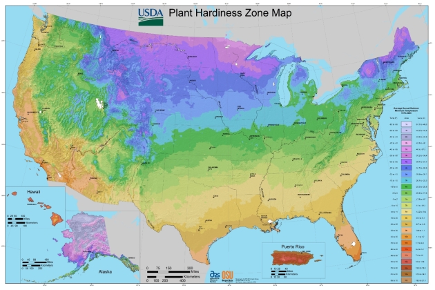
* new (warmer) Hardiness Zone Map above courtesy of the USDA.

Congregations Going Green. Here's an excerpt of an article in the Herald Sun: "Today the message of taking care of the earth as the duty of the faithful continues at United Church of Chapel Hill, where clergy are participating in a national “preach-in” on global warming. Sermonizing about global warming is happening across the country this weekend through the “Preach-In on Global Warming,” an event sponsored by Interfaith Power & Light. The outfit is designed to mobilize the faith community around renewable energies and to effect change in legislation. Nearly 60 members of the clergy and laity in North Carolina — the second highest participation in the nation — signed up for this weekend’s Preach-In. More than 15 percent of total participation is from the Triangle area. “We are really trying to create a movement from the heart and from our faith perspectives which will empower not only our congregations…but also the politicians who are charged with protecting the common good. We need to take that seriously,” North Carolina Interfaith Power & Light Director Kathy Shea said."