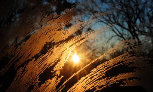
October 28. Today the sun will be as high in the sky as it was on October 28. Photo above courtesy of the AP.
95 minutes of additional daylight for northern tier cities since December 21. Source:
sunrisesunset.com.
Warmest Valentine's Day? Today will bring highs in the upper 30s, nearly 10 degrees above average. We won't be close to record territory though. The all-time record high (modern-day records) for February 14 in the Twin Cities is 50, set in 1882.
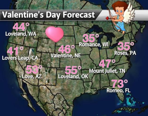
Valentine's Day Outlook. Who wouldn't want to live in a town called "Romance"? A mild day on tap for Romeo, Florida, a bit chilly in Roses, Pennsylvania, a chance of windblown rain and snow showers for Lovers Leap, California. Good to know.
Valentine's Day Storms:
FEBRUARY 14TH, 1899. A great blizzard struck the eastern U.S. Washington D.C. received 20.5 inches of snow to bring their total snow depth to nearly three feet. The storm produced 36 inches of snow at Cape May NJ. More from
NOAA: "
That winter (1898-1899) was so cold over a large part of the US that ice flowed from the Mississippi River into the Gulf of Mexico! The only other time that this has been seen was on February 13, 1784, when ice flows blocked the Mississippi River at New Orleans and then passed into the Gulf of Mexico." Photo: Maryland Weather @
Baltimore Sun.
FEBRUARY 14TH, 1940. A "Saint Valentine's Day Blizzard" hit the northeastern U.S. Up to a foot and a half of snow blanketed southern New England, and whole gales accompanied the heavy snow stranding many in downtown Boston.
"The Year Without A Winter". O.K. It's a matter of semantics. Of course we had winter, but it's been unlike anything any of us have experienced. You have to go back to the late 1800s to find something even remotely comparable. The Winter of 1887-88 was a bit milder, but there was more snow that winter. At the rate we're going we may be telling our grandkids about this some day down the road. Don't think it's been that strange? Read on...
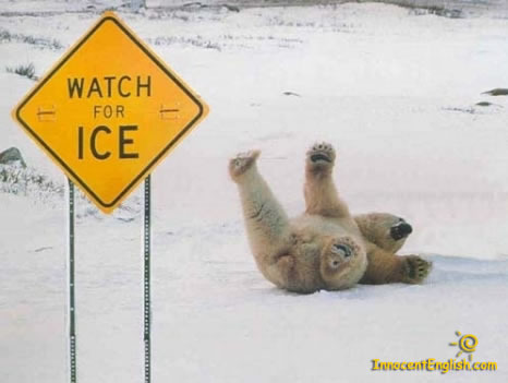
12 days in single digits or colder so far this winter in the Twin Cities. That's the
fewest on record since 1891, according to weather records. Photo: innocentenglish.com.
38 days: average number of days in the metro colder than 10 F. by February 14. Source: Pete Boulay, MN State Climate Office.
Subzero Nights At KMSP:
2: 2001-2002
3: 2011-2012 (so far)
4: 1877-1878
5: 1930-1931
6: 2005-2006
Tie for the latest subzero night (January 18th). Temperatures dipped below zero one minute before the 19th, or we would have set a new all-time record. This ties 2001-2002 and 1888-89 for the latest subzero in the Twin Cities.
-11 F. coldest temperature so far this winter. This is a 5-way tie for the 3rd warmest winter minimum. The all-time warmest minimum temperature was -3 F. in 2001-2002.
Winter Snowfall to date:
14.9" (21.8" below average). Last year we had picked up 61.1" in the metro area.
Least Winter Snowfall In The Twin Cities:
1).
14.2" (1930-31)
* 2).
14.9" (2011-12) so far.
3).
16.2" (1894-95)
4).
17.4" (1986-87)
5).
19.1" (1958-59)
* thanks to WeatherNation meteorologist Todd Nelson for helping me to pull all these (amazing) facts together. Also, a tip of the hat to Pete Boulay at the Minnesota State Climate Office, which does a terrific job tracking weather statistics
5 records so far this winter at KMSP for warmest high or warmest minimum temperatures.
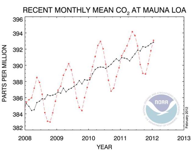
 393.09
 ppm. Carbon dioxide level at Mauna Loa, Hawaii in January of 2012. Source:
NOAA.
280 ppm. Carbon dioxide levels during pre-industrial times. Details below.
Right. Some help you were this winter wooly bear caterpillar. La Nina, La Schmeena....
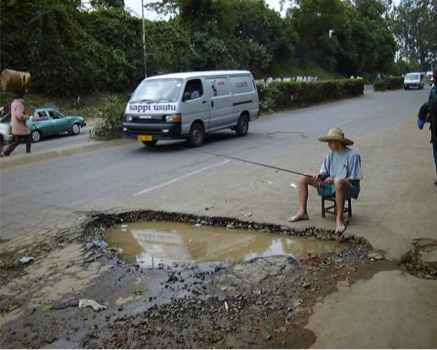
Pothole Alert. The only thing I can predict with (rare) 100% accuracy: potholes. The dreaded freeze-thaw cycle, which normally arrives in March, has come early this year. Here's the problem: water is one of the few elements that expands when it freezes. During the day temperatures rise above freezing, allowing water to seep into tiny cracks in highway surfaces. At night the mercury dips below freezing, water freezes, expanding, which can pulverize roadways over time, carving out crater-size potholes. All that money we're saving on snow removal this "winter" may have to go toward patching up the roads in the weeks to come.
Dark Chocolate is good for your heart. So is yoga, medition and prayer. People who are lovesick, suffering severe emotional trauma, have an increased risk of heart ailments, according to medical research. Hey, I know I'm a weather-guy, but I'm not making this up! More facts and figures from the Cleveland Clinic
here. There. It's official.
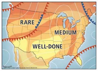
Winter Well Done. Yes, this map pretty much sums it up.
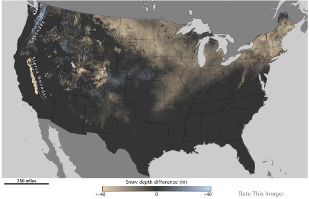
Fierce 2010-2011 Winter Dwarfs This Season's Snowfall.
NOAA's ClimateWatch has the details: "
People in the Midwest and Northeast who recall last year’s fierce winter might be feeling thankful that their shovels have not seen as much action this season. But for others, the lack of snow is causing major problems. Around the country, the bare ground is to blame for winter festival cancellations, bummed-out winter sport enthusiasts, and more seriously, challenging times for ski resort managers and other people whose livelihoods depend on the arrival of snow. The maps above show estimated snow depth across the United States as of December 31, 2011, and again on February 7, 2012, compared to conditions on those same dates the previous winter. Places where snow depth was up to 40 inches deeper this year are blue, while places where snow depth was up to 40 inches less than last year are gold. Dark grey represents locations where there was no difference in snow depth between the two years, including places that had no snow either year."
Precipitation Since December 13, 2011. This
NOAA graphic shows precipitation percentage of normal for the last 60 days. The lack of snow (or rain/ice), especially over western Minnesota, is very significant. I have a bad feeling about the drought. I truly hope I'm wrong, but based on recent trends I suspect Minnesota's drought may worsen in the weeks and months to come.
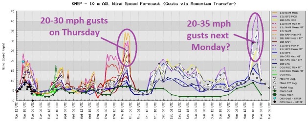
More Southerly Detours. No major storms are brewing (yet). Tell me if you're heard this before. A "plowable" accumulation is possible south of St. Louis, a few inches from northern Pennsylvania into upstate New York, otherwise the maps look amazingly quiet. NAM forecast above shows expected snowfall from now through Thursday night at midnight. Map courtesy of NOAA and WeatherCaster.
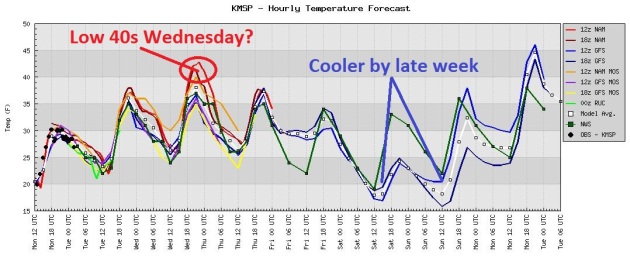
More Like Early March. Why should this week be any different? Highs peak in the 38-43 F. range Wednesday before cooling off (slightly) by late week, but even Friday and Saturday temperatures will be close to average for mid February. Another warming trend is likely by early next week - the models all in pretty good alignment.
Peak Winds. The models are hinting at a gusty Thursday (as slightly cooler air arrives with a weak clipper sailing across the state). A more significant area of low pressure by Monday of next week may spark a light rain/snow mix, along with wind gusts over 30 mph.
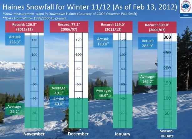
Record-Smashing Winter In Alaska. Check out these stats from Haines, Alaska, courtesy of the National Weather Service: "
Haines is experiencing a record-breaking winter so far in terms of snowfall. November 2011 is the snowiest since record keeping began in 1999, running 519% above average! December kept close to seasonal averages, but January 2012 is the snowiest on record, pegging in at 154% above average. The winter of 2011-2012 is the 2nd snowiest thus far, with the Season-To-Date snowfall total at about 74% above average."
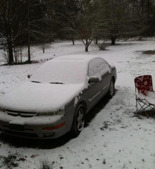
Arkansas Snow Event. About 1-2" slushy snow fell on Pearcy, Arkansas earlier today. Photo courtesy of the Little Rock National Weather Service.
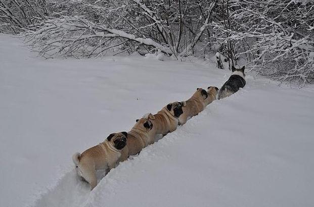
Mystery Photo. This pic is rocketing around the web. No idea where it was shot, or by whom, but it's pretty funny. What are these pugs doing? Where are they going? That's a collie at the front of the pack. Love this photo.
Early Allergies. A friend in Atlanta sent me the following note: "
except for the brief cold shot this past weekend it's felt more like the Florida Panhandle. Trees and flowers are blooming and last week the pollen was causing early allergy problems for many folks." File photo: AP.
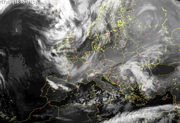
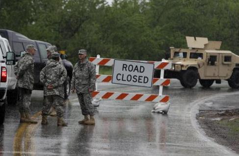
Military Planes Fly Food Into Snowbound Towns.
USA Today has the details: "
BUCHAREST, Romania (AP) – Military planes flew in tons of emergency food Monday to towns and villages in eastern Romania where thousands have been stranded by blizzards. Some people had to cut tunnels through 15 feet of snow to get out of their homes. Since the end of January, Eastern Europe has been pummeled by a record-breaking cold snap and the heaviest snowfall in recent memory. Hundreds of people, many of them homeless, have died and tens of thousands of others have been trapped by blocked roads inside homes with little heat. Authorities declared an alert Monday in eastern Romania, where 6,000 people have been cut off for days. About a dozen major roads were closed, 300 trains canceled and more than 1,000 schools shut down." Satelite image courtesy of EUmetsat, the Met Service and
sat24.com.
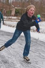
The Dutch Get Ready For A Rare Ice Skating Race. The details from
neatorama.com: "
Europe has had a hard winter, but the upside may be that the Netherlands gets to hold a rare ice skating race. The Elfstedentocht is conducted in the province of Friesland whenever the 125-mile course of canals and lakes has frozen to a thickness of six inches: Called the Elfstedentocht (or in English, the Eleven Cities Tour), the race is a roughly 200 kilometer trek across the frozen landscape and takes, at its fastest, over six hours. For the race to occur, the ice must be at least 15 centimeters thick throughout the course — which is rare. While the tradition of skating from city to city dates back to 1760, the race was not formalized until 1909. In the century-plus since, the Elfstedentocht has only taken place 15 times and not since 1997."
Cold Weather Behavior. Thanks to
Joke Of The Day for passing this along. Pretty true, come to think of it:
60 above: Floridians turn on the heat. Minnesotans plant gardens.
50 above: Californians shiver uncontrollably. People are sunbathing in Duluth.
40 above: Imported cars won't start. Minnesotans drive with the sunroof open.
32 above: Distilled water freezes. The water in Bemidji gets thicker.
20 above: New Mexicans don long johns, parkas and wool hats and mittens. Minnesotans throw on a flannel shirt.
15 above: New York landlords finally turn on the heat. People in Minnesota have one last cookout before it gets cold.
Zero: People in Miami evacuate the city. National Guard called out. Minnesotans close the windows.
10 below: Californians fly away to Mexico. Minnesotans dig their winter coats out of storage.
25 below: Hollywood disintegrates. Girl Scouts in Minnesota still selling cookies door to door.
40 below: Washington D.C. finally runs out of hot air. People in Minnesota let their dogs sleep indoors.
100 below: Santa Claus abandons the North Pole. Minnesotans get upset because their minivans won't start.
460 below: All molecular motion stops (Absolute Zero on the Kelvin Scale). People in Minnesota can be heard to say, "Cold 'nuff fer ya?"
500 below: Hell freezes over. Minnesota Public Schools open 2 hours late.
Arctic Oscillation: No Sign Of Bitter Air. A strongly negative AO and NAO (combined) correlates with weaker westerly winds, and a better chance of bitter air reaching the lower 48 states. The latest forecast through the first few days of March shows a largely neutral AO, which would hint at seasonable or slightly milder than average weather looking out 2 weeks. Graph above courtesy of
policlimate.com.
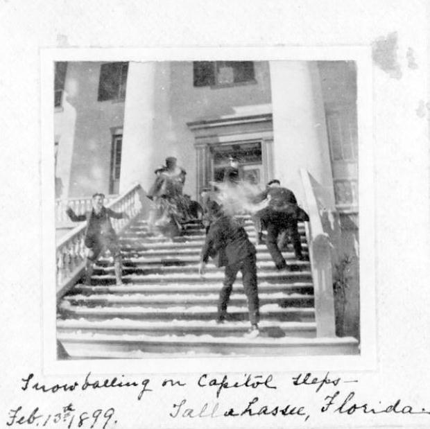
Snowball Fights In Tallahassee, Florida? O.K. This is obviously a file photo in the public domain, dating back to 1899. Details courtesy of the Tallahassee National Weather Service: "
It may have been a chilly start to the day today (20° low at the Tallahassee Airport), but it doesn’t compare to this date in 1899. The all-time record low for Tallahassee, and the state of Florida, of -2° was set on February 13, 1899. Snow also fell just prior to that record low in 1899. Here is a public domain photo of a snowball fight on the capitol steps in Tallahassee."
Severe Weather Awareness Week in Mississippi. Here's an excerpt of a story from the
Hattiesburg American: "
Today is the first day of Severe Weather Awareness Week in Mississippi. The purpose of this week is to encourage everyone to exercise their preparedness plans. Thunderstorms can produce cloud to ground lightning, large hail, tornadoes, and flash flooding. All thunderstorms can cause damage, but the national weather service reserves the term severe thunderstorm for those that produce wind gusts 58 mph or greater and or hail 1 inch or larger in diameter. Straight line damaging winds are common across Mississippi especially during the spring and summer months. These storms can knock down trees and cause damage to structures."
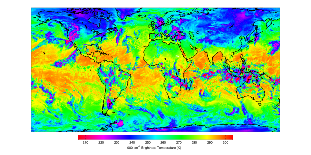
New Satellite Instrument For Improved Weather Forecasts Put Into Service.
NOAA reports: "
A powerful instrument designed to give scientists more refined information about Earth’s atmosphere and improve weather and climate forecasts is now active and sending its first data back to Earth from America’s newest polar-orbiting satellite. The Cross-track Infrared Sounder (CrIS) will produce high resolution, three-dimensional temperature, atmospheric pressure, and moisture profiles that will be used in NOAA’s weather prediction computer models to forecast severe weather days in advance. Over longer timescales this information will also help scientists understand climate phenomena such as El Niño and La Niña."
Photo credit above: "
In this CrIS image the orange colors represent very warm sea surface temperatures, while magenta represents both very cold temperatures, as well as high-altitude cloud tops. When all of CrIS’s channels are used, users and scientists can obtain detailed, three dimensional views of atmospheric temperature and moisture." Credit: NOAA/NASA.
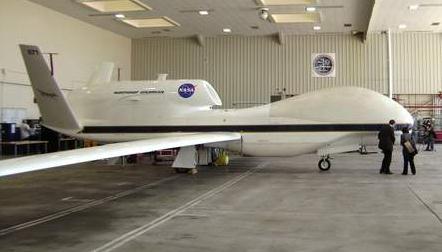
Drones To Scour The Clouds For Hurricanes' Secrets. Some interesting details on the use of civilian drones from
The Herald Tribune: "
NEW ORLEANS -
Scientists have found a new weapon in their long struggle to understand how tropical storms can suddenly morph into killer hurricanes: U.S. Air Force drones. A drone happened to catch Tropical Storm Karl's intensification off the Mexican Gulf Coast two years ago, providing an unprecedented 3-D view of the transformation at work. That mission's success has prompted new research that will include two drones — called Global Hawks — monitoring more hurricanes this September with some of the most advanced weather equipment on the planet." Photo courtesy of NASA.
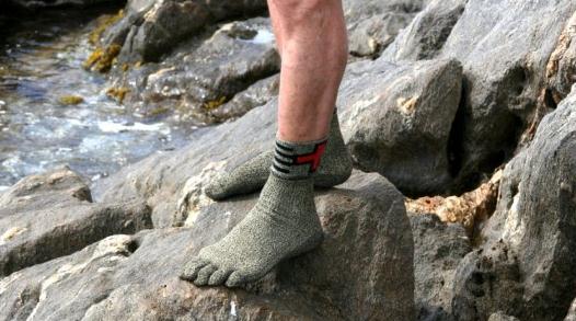
Furry Sock Shoes Designed For Walking, Running And Sports. Yep, they look strange, but who are we to judge?
Gizmag.com has more details:
"Swiss Protection Socks from Swiss Barefoot put a whole new spin on the barefoot movement. These are essentially big, burly socks that are designed to be worn not inside shoes, but instead of them. The manufacturer claims that the socks are hefty enough to protect your feet from the pain and dangers of walking completely barefoot."
New Media Vs. Old. Guess Who's Losing? I guess this was inevitable, with so much (free) content on the web, updated in real time.
Elpasoinc.com has the gory details: "
Not even Kim Kardashian's 72-day now-you-see-it-now-you-don't marriage to Kris Humphries was enough to reverse the slumping sales of celebrity magazines in the second half of 2011. Single-copy sales of consumer magazines, especially many women's and celebrity publications, dropped 9.96 percent, to 28.9 million from 32.1 million, compared with the second half of 2010, according to a report released by the Audit Bureau of Circulations. The five magazines with the highest newsstand sales - Cosmopolitan, Woman's World, People, First for Women and In Touch Weekly - all reported declines."
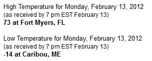
87 Degree Spread. The warmest reading in the lower 48 states Monday was Ft. Myers, Florida, at 73 - in stark contrast to a nippy -14 F. at Caribou, Maine Monday morning. Source:
NOAA.
Better Than Chocolate?
Happy Valentine's Day. You didn't forget, did you? There's still time. Maybe cut out the weather page and put a bow on it? Better than chocolate or roses! O.K. Maybe not.
From Roses, Pennsylvania to Romeo, Florida to Love, Arizona to Valentine, Nebraska: unusually mild weather will be our biggest gift. Snow lovers are in a brown, gritty funk, but the USA is saving BILLIONS on heating bills and snow removal, giving the economy an additional jolt.
MSP statistics are amazing: the warmest meteorological winter (since December 1) since 1877-78. 11 days of single digits this winter (average is 38). 5 records. The second fewest number of subzero nights on record (3). A 5-way tie for the warmest winter minimum temperature (-11 F.). The second least winter snowfall, to date, on record - our meager 14.9" second only to the 14.2" that amazed Minnesotans in 1931.
The drought is bad enough, and may amplify in the weeks ahead. NOAA is forecasting La Nina to weaken by spring. That may allow moisture-laden southern storms to (finally) reach Minnesota, but this year all bets are off.
The mercury kisses the 40-degree mark tomorrow; daytime highs above 32 F. every day through the end of February. Remarkable. Storms stay south; the only thing I can predict with 100% accuracy: potholes.
Climate Stories....
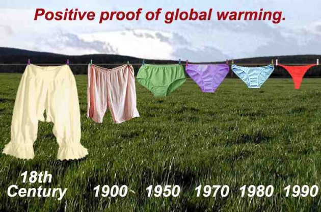
Definitive Proof? O.K. Let's try and keep our sense of humor and some degree of civility as we "argue the science", but the swimsuit trends are pretty compelling evidence eh?
With Climate Change, Today's "100-Year Floods" May Happen Every 3-20 Years. The story from
physorg.com:
Last August, Hurricane Irene spun through the Caribbean and parts of the eastern United States, leaving widespread wreckage in its wake. The Category 3 storm whipped up water levels, generating storm surges that swept over seawalls and flooded seaside and inland communities. Many hurricane analysts suggested, based on the wide extent of flooding, that Irene was a “100-year event”: a storm that only comes around once in a century. However, researchers from MIT and Princeton University have found that with climate change, such storms could make landfall far more frequently, causing powerful, devastating storm surges every three to 20 years. The group simulated tens of thousands of storms under different climate conditions, finding that today’s “500-year floods” could, with climate change, occur once every 25 to 240 years. The researchers published their results in the current issue of Nature Climate Change."
Saudi Arabia's Surprising About-Face On Climate Change. The story from Kelly Rigg at
Huffington Post: "
At a speech delivered in late January (PDF), the Saudi Minister of Petroleum and Mineral Resources said: "Greenhouse gas emissions and global warming are among humanity's most pressing concerns. Societal expectations on climate change are real, and our industry is expected to take a leadership role. We are doing this in Saudi Arabia." It's worth repeating; this was said by the Saudi oil minister. But let's not get overly excited. The Minister also said: "In 2009, the Kingdom completed a massive program to increase oil production capacity. This investment and effort is aimed at retaining our position as number one supplier of oil to the world and the investment continues." My point is simply that formal Saudi recognition of the need to get to grips with climate change is a major about-face. The speech signalled that the Saudis may be prepared to play a more progressive and less obstructionist role in the negotiations. And just last week we heard that Al-Sabban will be replaced by the well-respected Khalid Abuleif as the leading voice of Saudi Arabia at the climate negotiations."
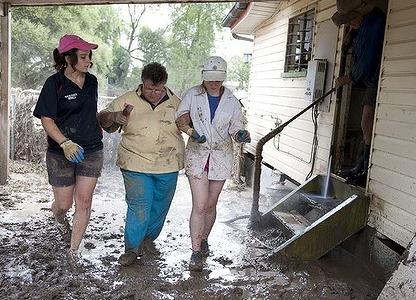
Climate Change Role In Floods Won't Be Clear For A Decade, Say Scientists. Yes, there are some discrepencies even within the scientific community about whether a warmer (wetter) atmosphere will spark more flooding, and with what frequency. Here's an excerpt from the
Sydney Morning Herald: "
Leading climate researchers said the frequency of El Nino and La Nina events that bring drought and flood to Australia seems to have increased in the past 30 years, even though such events have been occurring independently of human influence for far longer. ''It's completely naive to exclude climate change as a contributor to the floods because of the rapid warming of the oceans, but we are not yet at the stage where we can be too specific about individual events,'' a climate researcher at the University of NSW, Matthew England, said."
Photo caption above: "
Trying time … volunteers help Patricia Budd as she returns to her home in Mitchell, about 500 kilometres west of Brisbane, to survey flood damage. Photo: Harrison Saragossi."
Global Warming: Bacteria A Wild Card In Ocean Carbon Cycle. The story from the
Summit County Citizens Voice: "
As the upper layers of the ocean warm there will less mixing of water. Increased stratification will probably have a profound impact on microbes and plankton that pump carbon out of the atmosphere – but researchers say it’s still unclear whether these processes will increase global warming or decrease it. The forces at work are enormous and the stakes huge, according to Oregon State University scientists who last published an article on the topic in the journal Science. “We’re just beginning to understand microbial diversity in the oceans and what that may mean to the environment,” said Stephen Giovannoni, an OSU professor of microbiology. “However, a large portion of the carbon emitted from human activities ends up in the oceans, which with both their mass of water and biological processes act as a huge buffer against climate change. These are extremely important issues.” Photo courtesy of NOAA.
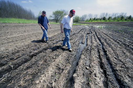 Soil Erosion Increasing Global Warming Threat: UNEP
.
Reuters has the story: "
Global warming will get worse as agricultural methods accelerate the rate of soil erosion, which depletes the amount of carbon the soil is able to store, a United Nations' Environment Programme report said on Monday. Soil contains huge quantities of carbon in the form of organic matter. which provides nutrients for plant growth and improves soil fertility and water movement. The top meter of soil alone stores around 2,200 billion tonnes of carbon, which is three times the level currently held in the atmosphere, said the UNEP Year Book 2012. "Soil carbon is easily lost but difficult to rebuild," the report said." Photo: Star Tribune.
 Debate In The Media - No Debate Among Published, Peer-reviewed Scientists
. From an article at the
Huffington Post: "
The global warming consensus is more often debated in the popular media where a he-said, she-said reportage is used than among scientists. In fact, the U.S. Climate Change Research Program reported in 2009 that: Observations show that warming of the climate is unequivocal. The global warming observed over the past 50 years is due primarily to human-induced emissions of heat-trapping gases. No scientific organization of international standing disagrees: A 2010 paper in the Proceedings of the National Academy of Sciences analyzed "1,372 climate researchers and their publication and citation data to show that (i) 97-98% of the climate researchers most actively publishing in the field support the tenets of anthropogenic climate change outlined by the Intergovernmental Panel on Climate Change, and (ii) the relative climate expertise and scientific prominence of the researchers unconvinced of anthropogenic climate change are substantially below that of the convinced researchers."
* graph above showing an increase in carbon dioxide levels at Mauna Loa, Hawaii courtesy of
NOAA.
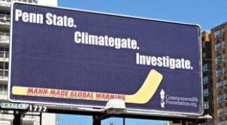
More Than A Free Lunch: $500 Reward For Exposing (Climate Scientist) Michael Mann In Los Angeles (Monday). Wow. It's come to this? Paying deniers to show up and badger climate scientists? $500 a question? From the web site
Junk Science: "
Michael Mann is taking his book tour today to the UCLA School of Law. We will pay $500 for a video of someone asking Mann an alarmism-debunking question at his presentation."