
10 hours, 30 minutes of daylight today.
104 minutes of additional daylight since December 21 in the Twin Cities.
.23" liquid predicted for the Twin Cities next Monday (NAM model). With temperature close to freezing I could see a mix of rain and snow ending as snow, a coating to an inch of slush possible Monday night on lawns and fields, while most main roads stay wet.
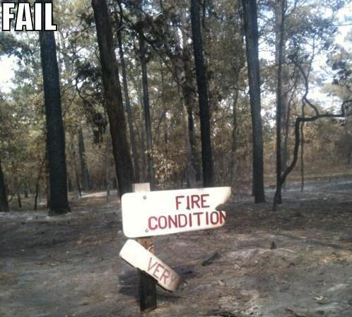
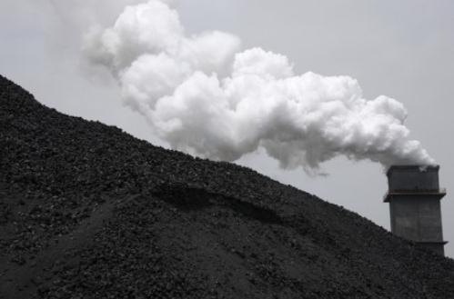
4X. According to Dr. Mark Seeley, midwinter rain and ice events have increased four-fold in the Twin Cities since 2000.
"Viewers tracking storms on television will perhaps most embrace the intelligence from the dual polarity that indicates whether or not a tornado has actually touched down. The key, Baron said, is that the dual polarity can identify the size of objects in the air - from large raindrops to small ones to even snow. And a common trait of a tornado on the ground is the debris it picks up. If there is a cluster of debris, that's a strong indicator of a touchdown." - from an article on dual polarization Doppler radar and Baron Services, a pioneer in radar technology, in a blog post at al.com below.
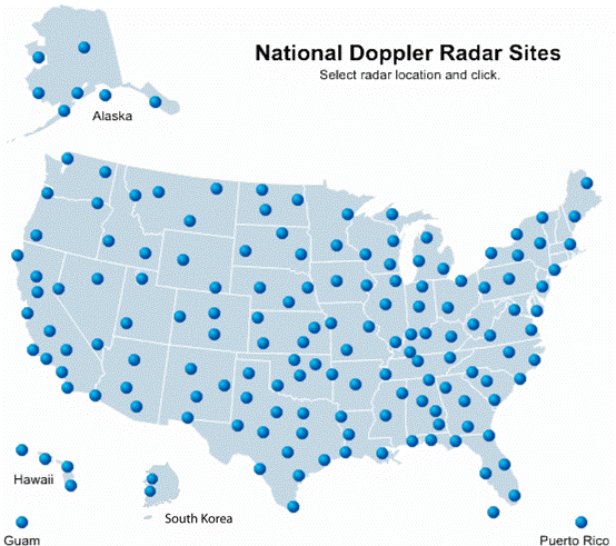
171 "Nexrad" (next-generation) National Weather Service Doppler radar systems across the USA, providing nearly continuous radar coverage from coast to coast. Map source: NOAA.

"Three states (Louisiana, Texas and South Dakota) have passed so-called Environmental Literacy Improvement Act bills — written by energy industry shills — that require schools to teach climate change “denial” along with conventional climate science. Other states are considering such measures." - from an article at salon.com below. Photo credit here.
"Research has shown that people are motivated to find information that supports their beliefs. "Encountering counterarguments causes us to marshal forces like an army of white blood cells to defend against them."
"Gallup and Pew polls show that the percentage of Americans that believe in climate change now hovers around 50 percent, but Krosnick's latest poll -- which asked the question in a more detailed way -- suggests the figure is 83 percent -- up from 79 percent in 1997. Of the global warming believers, the majority also reported thinking that the burning of fossil fuels and other human activities play a role. The trend held after the researchers broke the data down by political party: 66 percent of Republicans said climate change is happening." - from a Huffington Post article below.
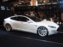
2 cents/mile. Average cost of driving an EV, or electric vehicle. Source: Dept. of Energy, Tesla Corporation. Photo of Tesla Model S above courtesy of Wikipedia.


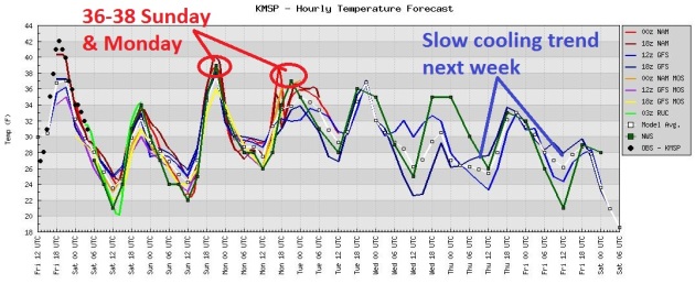
Above Average Temperatures Through Most Of Next Week. A cool Saturday (close to average for mid February) gives way to upper 30s Sunday and Monday, followed by a slow cooling trend the latter half of next week. Nothing arctic - but by the end of next week it may actually start to feel like February again.
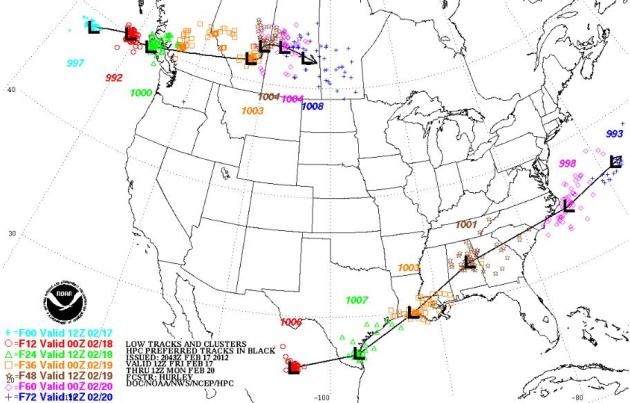
* storm tracks and timing above courtesy of NOAA NCEP.
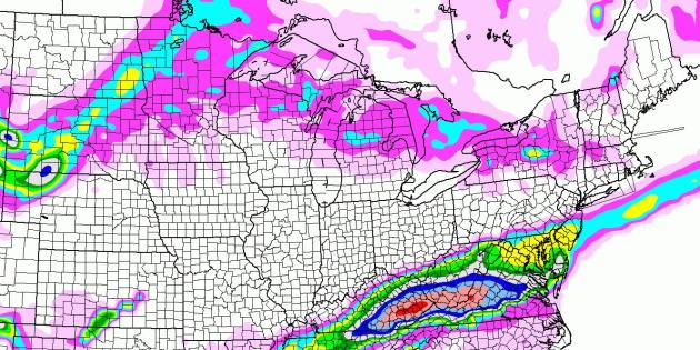
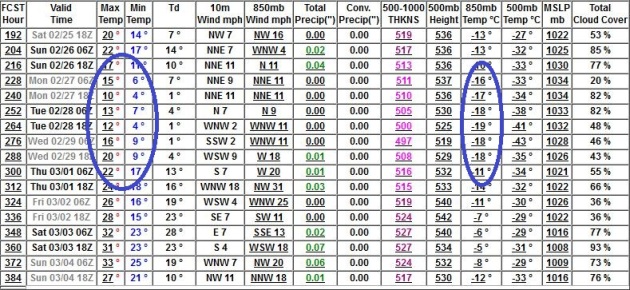
Latest Snowfall Prediction. The NAM is still printing out some 8-16" snowfall amounts for southeastern Kentucky and West Virginia, a plowable accumulation into central Virginia, with 1-3" possible for Washington D.C., a coating to 1" for Philly and south Jersey. Monday's (weak) storm over the Upper Midwest may drop a couple inches of slush on the Red River Valley, little snow expected in the Twin Cities metro area.
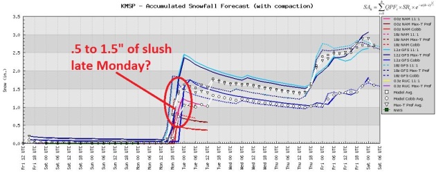
As Good As It Gets. A (warm), slow-moving and weakening area of low pressure may squeeze out a quick inch of slush Monday night, a better chance of a couple inches of snow over far western Minnesota. Models are hinting at another inch or so of snow next Thursday as temperatures begin to fall. Nothing but (meager) clippers. Yes, we are most definitely in a snow recession.
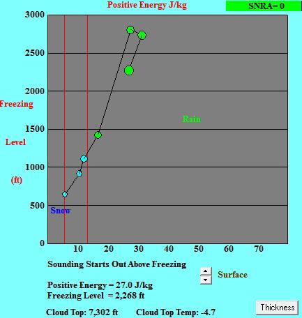
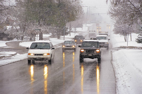
Monday Mix? The Bufkit plot from last night's 00z NAM run shows a little wet snow Monday afternoon changing over to a cold rain Monday evening as temperatures aloft rise above 32 F. That leads me to believe that we won't see 2" of snow, maybe a sloppy coating to an inch of slush - before the changeover to rain. With surface temperatues just above freezing I suspect most roads will stay wet. A late February snow is different than a (cold) early January snow. Considering the maps look more like mid March I guess we shouldn't be too surprised that we'll see a mix of rain/snow.
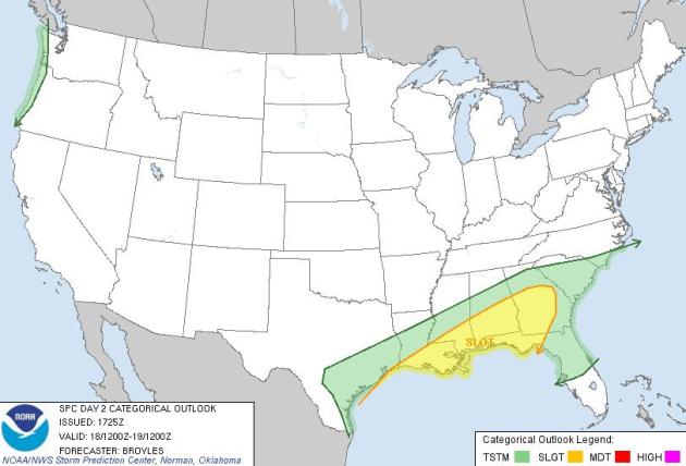
Saturday Severe Threat. SPC shows a slight risk of severe storms, including a potential for isolated tornadoes, from southern Louisiana to Montgomery, Birmingham and the Atlanta area, as well as parts of the Florida panhandle.
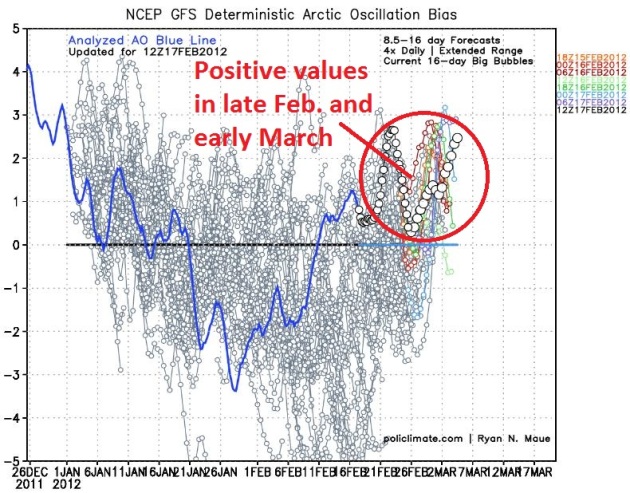
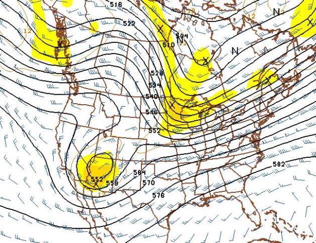
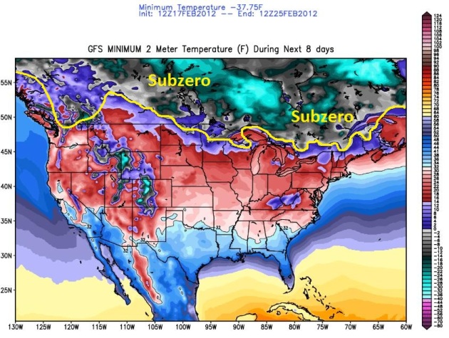
One More (Real) Cold Front? The GFS is fairly consistent bringing one more surge of numbing air south of the border during the last few days of February. It won't stay cold for long - a few days in the teens and 20s; not even sure we'll dip below zero in the metro area. But keep the heavy jackets handy. Winter isn't quite done with us just yet. GFS 500mb forecast above valid February 29.
Shiver-Potential. Although no big storms are in sight (where have you heard THAT before?) the GFS and other models are fairly consistent pulling nippy air south of the border between February 26 - February 29; maybe 2 or 3 days of minor pain and scattered goosebumps. The GFS drops metro lows into single digits, but a lack of significant snowcover may keep the mercury above zero at KMSP.
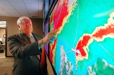
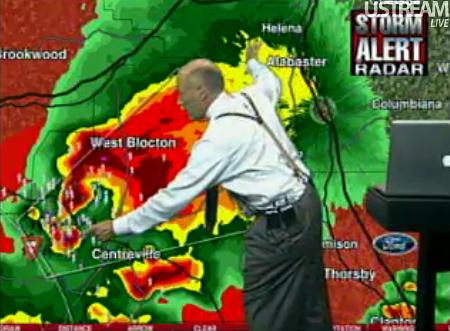
Former TV Meteorologist Bob Baron Making World Safer From Tornadoes. I'm proud to say I know Bob Baron; he's a true entreprenuer and pioneer - he built Baron Services from scratch down in Huntsville, and he's been on the cutting edge of radar technology for the better part of 25 years. In fact we use Baron technology on the air - their Vipir Doppler system, which can tap into NWS Nexrad radars and live, local TV radars as well - there's no better tool to analyze severe thunderstorms. KARE-11 also has Vipir, which does a remarkable job isolating the rotating T-storms that often go on to spawn large hail and tornadoes. The Birmingham News has the story at al.com: "HUNTSVILLE, Alabama -- Bob Baron is sitting in his sprawling office on the second floor of his tornado business and seems almost amused at the repeated questions about April 27. For some, April 27, 2011, was the day that tornadoes became TORNADOES. For some, every dark cloud off to the west now gets an extra glance or two. For Baron, he's more than 20 years ahead of you. "It really hasn't changed what we've done," he said. Baron, a former television meteorologist in Huntsville, founded Baron Services in the aftermath of the deadly Airport Road tornado in 1989. Ever since, he's been trying to demystify tornadoes."
Photo credit above: "Baron Services was founded in 1990. They worked in the development of Doppler weather radar including dual-polarization radar technology. Their equipment and software is in a number of broadcast TV station. They are working with L-3 STRATIS to upgrade 171 NEXRAD installations with dual-polarization capability for the U.S. National Weather Service, Federal Aviation Administration and Department of Defense. Bob Baron talks about the tornado outbreak on April 27, 2011. Screen on right is tornado track of one of the F5 tornadoes which hit Ala. (The Huntsville Times/Dave Dieter)."
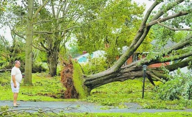
Photo credit above: "Within the past year, a string of damaging and expensive natural disasters, including tornadoes, a hurricane, a tropical storm and earthquake tremors have all caused damage in the region. The Daily Times/file photo."
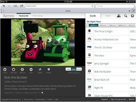
Start-Up Sends Live Local TV To iPhones and iPads. This is bound to trigger a fight with local broadcasters, who are paid by cable systems to retransmit their signals. Aero gets around this by selling a small antenna, which then makes it legal, or so they hope. Plenty of additional billable hours for lawyers involved with this one, but once the genie is out of the Internet-bottle, it's going to be tough to put it back in. More from AP and MSNBC.com: "A startup backed by media billionaire Barry Diller has launched a service that sends live local TV feeds to iPhones and iPads. But the service may be short-lived, since TV stations are likely to challenge its right to use their broadcasts. The service, Aereo, launched in New York this week, but it is available only by invitation. It hopes to broaden access to more people next month, and then launch in other cities. Subscribers pay $12 per month and use their web browsers to access streams from 27 local channels, including the major broadcast networks ABC, CBS, NBC and Fox. For now, the service works only on iPhones, iPads and iPod Touches, but Aereo is planning to make it accessible to PC browsers and Android-powered phones as well."
"There is talk of an early spring. Do your records remember when farmers were doing field work around Northfield on March 4, 1981? That may be a year or so off. I remember that clearly, because it was my birthday. I had never before seen such early field work, and I have not seen it since. I am almost 79 years old.
Gloria Kiester
Dear Gloria- I didn't get to the Twin Cities until March of 1983, but I teed up your question with Pete Boulay over at the MN State Climate Office. It turns out there was a spell of remarkable warmth in mid February, 1981. Here is what Pete said:
"I remember it well. Back in 1981 the Twin Cities was in the middle of a 5-day streak in the 50s, and one 60. It was great to walk outside and watch the snow melt away." - Pete Boulay, MN State Climate Office.
http://climate.umn.edu/doc/twin_cities/msp1980's.htm
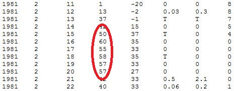
One Amazing Warm Front. Check out the numbers from mid February, 1981. After waking up to -20 F. the morning of February 11, the high in the Twin Cities reached 60 just 5 days later! Data courtesy of the MN State Climate Office.
__________________________________________________________________________
Dear Paul,
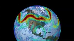
I was a pilot in WWII and every morning a weather balloon was released to gather the current conditions. Now you have the jet stream. My question is how is the jet stream located? It must be invisible. Is it by radar or computer? I'll be watching the daily paper for an answer.
Yours truly,
Walter Miller
Plato, Minnesota
________________________________________________________________________
Paul, I am a recently retired investment banker who wants to learn more about weather - understanding weather terms, patterns, influences on local weather, tools for forecasting near term weather. Are there any college/university weather courses that you could steer me towards here in the Minneapolis - St.Paul metropolitan area.
Thanks
Steve Yanisch
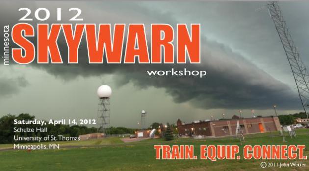
Steve- Although the U. of Minnesota doesn't offer a meteorology degree (not quite sure why they don't) you might be able to audit an introductory meteorology course there - worth a shot. The only school in Minnesota where you can get a 4-year meteorology degree is St. Cloud State University. Again, they may have some options to sample classes that I'm not aware of. There is so much (good) information on the web now - a simple Google search will keep you busy for months to come. UCAR at Boulder offers a "Comet Virtual Classroom", which delve into incredible detail on every kind of meteorological phenomenon. The National Weather Service offers up "Jet Stream: Online School For Weather", which has some great information. Another good option: attend the 2012 Skywarn Conference at the University of St. Thomas on April 14. The emphasis is severe weather, but you'll make some contacts and connections which may lead to more opportunities. Good luck!
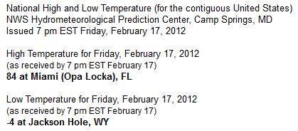
National Highs And Lows For The Lower 48 States, courtesy of NOAA.
Winter On Hold
"Spring is when you feel like whistling even with a shoe full of slush," said Doug Larson. No slush in sight, but I'm whistling. Some part of me misses the snow, but - like many - I feel like I won the Winter Lotto this year. Like I went in for a root canal, only to discover my (sadistic) dentist mixed up the X-rays. Relieved.
We're not quite out of the woods - but I can see the edge of the forest coming into view. Dr. Mark Seeley reports 77 days above average since November 1 in the metro.
At the rate we're going (with a chilly end to February) this may wind up being the 3rd or 4th warmest meteorological winter since 1872. 3 subzero nights so far? If word gets out there'll be a line of minivans and SUV's rolling up I-35 any day now. You mean Minnesota doesn't get dreadfully cold anymore? It's cold enough, but the worst of the arctic fronts have been neutered since 1998.
Sunday's storm misses D.C, a few inches of snow for Tennessee and Virginia. A weakening storm may squeeze out 1-2" of slush Monday night, but the biggest storms track south of Minnesota through late February.
I've used my heavy coat only TWICE all winter. Keep a heavy jacket handy for late February.
* photo credit above here.
Climate Stories....
Dear Mr. Douglas,
Been meaning to drop you a quick note just saying thank you thank you thank you for your incredibly clear and courageous [sad that it is that] statement about climate change on Kerri's show, January 13. Bravo, I stopped what I was doing, clapped at the radio and wished more scientists were so articulate and pointed.
All the best,
Karin Preus
St. Paul, MN
Karin - I appreciate your note. I usually only hear from a very vocal minority, the skeptics, doubters and deniers on the subject of climate change. I don't pretend to be a climate scientist, but weather and climate are flip-sides of the same coin. Unlike some of the other TV meteorologists in town I do feel a professional obligation to report on climate science; what I genuinely believe will be one of the biggest, ongoing stories of the 21st century. I hope the scientists are wrong - but the body of data and evidence is pretty overwhelming, and getting bigger every year. I'll keep reporting on stories that catch my eye and share them with you - thanks for checking out the blog.
_____________________________________________________________________________
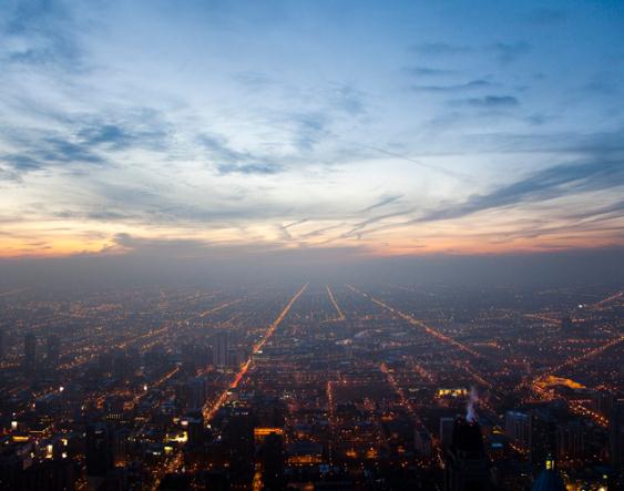
Photo credit above: "IMAGE: The sun sets over the city of Chicago, where Heartland Institute is having an open house at One South Wacker #2740 Drive on March 1. (Photo by Brooks Kraft/Corbis)."

Why Global Warming Still Considered Target Of Skepticism For Americans. Huffington Post has the story; here's an excerpt: "If you follow the popular polls, you might think that Americans are growing ever more skeptical about man-made climate change -- despite the consensus among published climate scientists. That's simply not true, Jon Krosnick of Stanford University told an audience of social scientists and cognitive researchers Wednesday, in Garrison, N.Y. He maintained that most Americans do, in fact, believe. The problem, Krosnick said during his talk at the Garrison Institute's annual Climate, Mind and Behavior symposium, is that we haven't been asking the public the right questions. The other problem: Legislators are reading their misleading answers and hearing from a vocal minority of constituents."
Secret Papers Turn Up Heat On Global Warming Deniers. Salon.com has more: "With Al Gore way down in Antarctica inspecting melting glaciers, and America’s unusually mild winter providing a respite from seasons of freakish droughts, floods, Nome-style whiteouts and the hurricane that ravaged Vermont, the issue of man-caused global warming has been out of sight and mind. But virtually all scientists continue to believe that most indicators suggest the world as we know it is slowly ending, and that humans are to blame. Nature – oceans, deserts, crops, animals and insects – is in the process of being transformed by rising temperatures due to the fuel we burn to stay warm or cool, and to power factories, cars and jets. In the academies, the argument now is only between experts who predict “bad” and those who predict “catastrophe.” Some people don’t want to hear it. Supporters of industries that profit from the fossil-fuel status quo routinely challenge those facts, and treat them as political talking points." Photo above: Reuters.
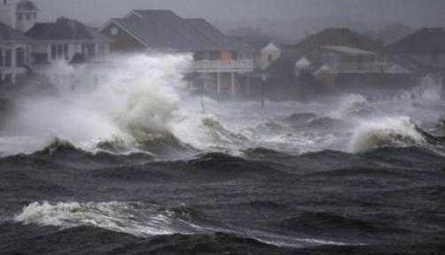
Global Warming Could Fuel More Frequent Storm Surges. USA Today has more details: "Last year's most devastating tropical system -- Hurricane Irene -- was considered by some experts to be a "100-year-event," a storm that comes around only once a century. Irene lashed the East Coast in August, killing at least 45 people and leading to $7.6 billion in damages. But a study out this week in Nature Climate Change says that due to global warming, these monster storms could make landfall more frequently, causing destructive storm surges every 3 to 20 years instead of once a century." Photo: AP


Photo credit above: "The Heartland Institute, whose strategy to undermine climate change was exposed this week, has non-profit status. Photograph: John Mcconnico/AP."
* An Open Letter To The Heartland Institute, courtesy of The Guardian.