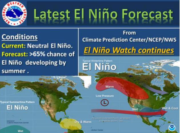
May Not
Hi.
Welcome to an emergency session of Paul's Weather Therapy. Lie down on
the sofa - prop up your feet - and tell me why you're feeling blue,
listless and anxious. Reoccurring nightmares of the Polar Vortex? The
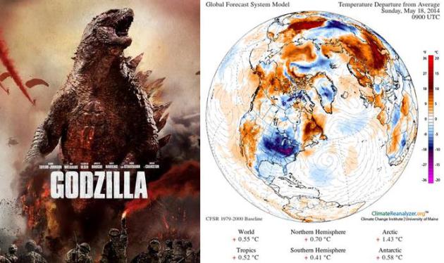
Godzilla of Cold Fronts? I share your sense of unease and angst.
We
shouldn't be tracking a few inches of snow over the U.P. of Michigan on
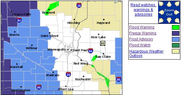
May 16. Frost advisories for greater Minnesota? Rare, but not
unprecedented this time of year.
The jet stream is still drunk,
recovering from a 5-month winter hangover; still prone to getting
tangled up in a slow-motion holding pattern where blobs of unseasonably
cold air stall out for days or weeks on end. This has spawned torrential
rains east of the Mississippi, while the west continues to fry - and
burn.
Cold air aloft sparks ragged clouds and a few PM sprinkles
today, but spring battles back as May windchill finally retreats
northward over the weekend. Expect 60s by Sunday, a few 70s next week.
T-storms are most likely on Monday.
It's still early but I'm
cautiously optimistic about a warm Memorial Day Weekend; highs in the
60s and 70s. Potentially warm enough to mow the lawn and take the boat
out for a maiden voyage.
Frost Advisories - Freeze Warnings.
Well, at least it didn't snow (here), although flurries were spotted in
Duluth yesterday. Frost Advisories are posted as close as St. Cloud and
Hutchinson this morning; Freeze Warnings for far western Minnesota.
Last year it snowed on May 3, but then the mercury spiked to near 100F a
little more than a week later. I see a few 70s next week, but still no
hot fronts in sight.
Slow Recovery.
Another chilly day is on tap today with any early sun giving way to
instability clouds, even a PM sprinkle or two (nothing heavy expected).
Expect more sun Saturday as the mercury approaches 60F; highs close in
on 70F Sunday. ECMWF guidance is hinting at 70s as we kick off Memorial
Day Weekend. Graphic: Weatherspark.
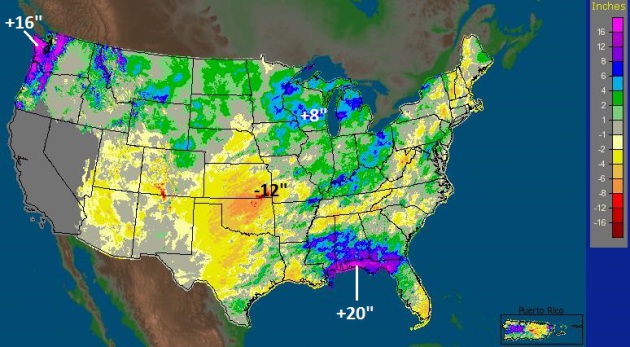
90-Day Precipitation.
I found the map above fascinating; extreme rains for the Pacific
Northwest and Gulf Coast, with precipitation well above average east of
the Mississippi, but precious little rain over the southern Plains and
NO rain to speak of for much of the southwestern USA. Source: NOAA.
90-Day Precipitation Departure from Normal.
A series of closed "cut-off" lows as created a quilt-work of moisture
haves and have-nots since mid-February. Much of Minnesota and Wisconsin
is 4-8" above average for the last 3 months, while farms near Wichita,
Kansas are running nearly a 12" rainfall deficit.
Wildfires From Space.
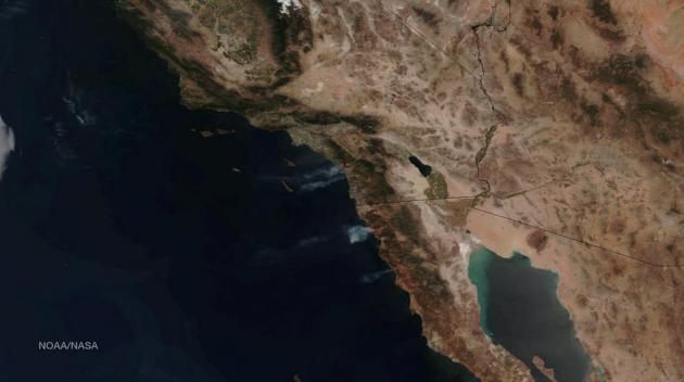
NOAA satellites shows the smoke and ash plumes from fires that continue to burn north of San Diego; more fires south of Tijuana, Mexico.
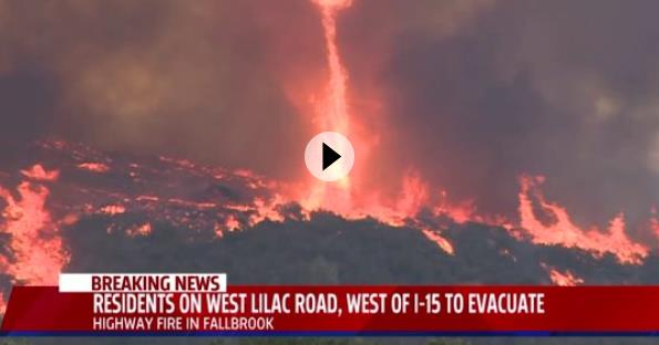
Firenadoes Spotted In San Diego Wildfires.
Fox43.com has video of one of these spinning updrafts of fire and ash; here's an excerpt of an explanation from
Vox: "...
Most
often, the cyclone sucks carbon-rich gases, produced by burning plants,
upward. At ground level, these gases might not come into contact with
enough oxygen (needed to fuel a fire) to burn, but once they're aloft,
they mix with fresh oxygen and start burning suddenly. Once this
happens, the extreme temperatures of a fire tornado (as high as
2,000°F) can be hot enough to re-ignite ash that's been sucked up from the ground — and mixed with fresh, oxygenated air — as well..."
10,000 Acres Already Scorched in SoCal Wildfires. Details from the
Los Angeles Times.
The Surprising Dangers of Hospital Stays. Dear God, please keep me out of the hospital, for a variety of valid reasons for concern.
Next Avenue has a few; here's an excerpt: "...
In
2011, there were 722,000 healthcare-associated infections in U.S.
hospitals. That means the patients didn’t come in with these infections —
they got them while being treated there. About 75,000 patients died
from these infections. Lots of patients get sick from hospital
infections, not just those who came in with severe health problems. In
fact, more than half the infections happened outside the intensive care
units at the hospitals..."
File photo: ThinkStock.
America Is The Top Consumer of Wine In The World. As if there was any doubt. Here's an excerpt from a story at
Eater: "
America officially dethroned France as the number one largest market for wine in the world last year. France is not only eating less baguettes, but the country is also drinking less wine. According to Reuters, France fell into second place for wine consumption for the first time in 2013. In 2013 American consumption went up .05% with US consumers buying 29.1 million hectoliters of wine, while the French only bought 28.1 Million hectoliters, meaning consumption in France fell almost 7%..."
Climate Stories....
Who Will Pay For Climate Change? Not Us, Insurer Says.
Here's news of a potentially precedent-setting legal case taking shape
in the suburbs of Chicago. Do cities have a (legal) responsibility to
prepare for more intense rains and frequent flood events?
Marketplace has the story; here's an excerpt: "...
Andrew Logan looks at the insurance industry for Ceres, a non-profit that coordinates private-sector efforts to address climate change.
“I think what the insurers are saying is: ‘We’re in the business of
covering unforeseen risks. Things that are basically accidents,’” Logan
says. “‘But we’re now at a point with the science where climate change
is now a foreseeable risk.’”
That would make local governments liable, in theory, for not upgrading
their stormwater-management systems to account for that risk..."
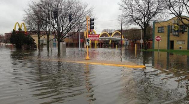
Photo credit above: Army Corps of Engineers, via flickr. "
Chicago's April 2013 rainstorms flooded basements and streets."
Picture This: U.S. Cities Under 12 Feet Of Sea Level Rise.
Far-fetched and alarmist? I sure hope so, but the reality is we really
have no idea how fast ice in Greenland and West Antarctica will melt in
the decades to come. Computer models have consistently underestimated
the rate of ice melt. Here's a clip from a story at Climate Central: "
Maps are one way to understand what collapse of West Antarctic glaciers
could eventually mean. Photos show it another way. In 2013, Climate
Central shared some of its sea level rise mapping data with artist Nickolay Lamm so
that he could develop photorealistic images of U.S. city scenes under
different future scenarios. One scenario was 12 feet of sea level rise —
right in the middle of the range now predicted due to the collapse of
key Antarctic glaciers under way. Here is what some classic American
city scenes would look like today with that much extra ocean..."
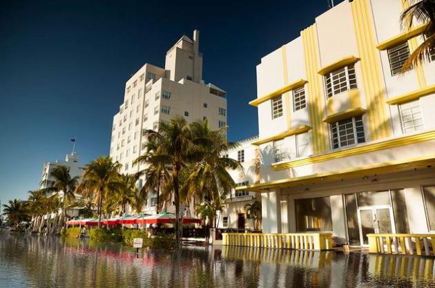
Photo credit: Ocean Drive in Miami with simulated 12 foot sea level rise -
Credit: Nickolay Lamm. Data: Climate Central
Tipping Points.
What's happening on the West Antarctica ice sheet is one of many
potential tipping points climate scientists are tracking, one of many
"known unknowns". Others include melting permafrost sparking more
methane releases, changing albedo accelerating warming over the Arctic,
and the rate of ice melt over Greenland. Climate Nexus has a list here.
April Was Second Warmest Globally, Average for USA.
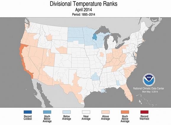
Climate Central has the details - here's the introduction: "
While
April was an uneventful month temperature-wise in the U.S., with most
areas experiencing near-average temperatures, the month was the
second-warmest April on record globally, according to new NASA data.
That makes April the 350th month in a row — more than 29 years — with
above-average temperatures, largely caused by the buildup of manmade
greenhouse gases in Earth’s atmosphere..." (Image: NOAA NCDC).
From Airports to Interstates: Global Warming Threatens Coasts.
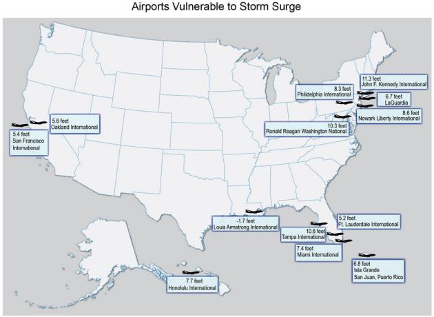
Here's an excerpt from a story focusing on transportation
infrastructure at increasing risk of rising seas and storm surges,
courtesy of
U.S. News: "...
More
than a dozen of the nation's 47 largest airports, meanwhile, have at
least one runway that sits within reach of moderate to high storm surge.
In fact, all three major airports around New York City – Newark,
LaGuardia and JFK – are all at risk, as are Philadelphia International
and Ronald Reagan Washington National..." (Graphic above: U.S. News).
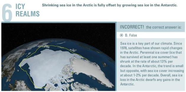
Shrinking Arctic Sea Ice Is Fully Offset By Growing Antarctic Sea Ice? False. So says NASA, which provided the graphic above.
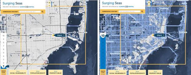
What Does U.S. Look Like With 10 Feet Of Sea Level Rise?
Granted, this won't happen next year, or even 20 years from now, but
some of the models are suggesting as much as 4-6 feet of rise by the end
of this century, depending on the rate of melting in Greenland and West
Antarctica. The honest answer is we don't really know how fast water
levels will rise. Here's a clip from an interactive tool at
Climate Central: "
New research indicates that climate change has already triggered an unstoppable decay
of the West Antarctic Ice Sheet. The projected decay will lead to at
least 4 feet of accelerating global sea level rise within the next
two-plus centuries, and at least 10 feet of rise in the end. What does
the U.S. look like with an ocean that is 10 feet higher? The radically
transformed map would lose 28,800 square miles of land, home today to
12.3 million people..."
U.S. Military Pressed on Climate Change.
The Pentagon is taking climate change seriously as a force-multiplier, a
potential catalyst capable of igniting local and regional conflicts
related to mass migrations linked to shortages of water and food - as
well as rapidly melting Arctic ice during the summer months and
potential skirmishes as countries jockey for mineral rights at the top
of the world. Here's a clip from
The Wall Street Journal: "
The
military panel that advises CNA also found that many changes were
happening more quickly than they predicted in 2007 in their latest
report that examined the national-security implications of climate
change. "For our national defense, we need to be making sure we are more
resilient for the changes we have locked in," said retired Adm. David
Titley, the former oceanographer of the Navy. "It is changing the battle
space the Department of Defense operates in..." (File photo: Hassan Ammar, AP).
