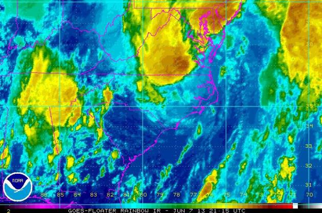
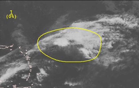
ANDREA looked like a much more formidable storm on Thursday, just prior to landfall. Typically, as tropical systems lift farther north from the tropics, wind shear becomes a problem and they tend to get torn apart. Tropical storms and hurricanes feed off of warm ocean water temperatures and light wind speeds aloft and those types of favorable weather conditions are generally found closer to the Equator. Look at the tropical satellite image from Thursday afternoon. Other than bright orange cloud tops over Virginia, it's really hard to see anything that would resemble a tropical cylone.
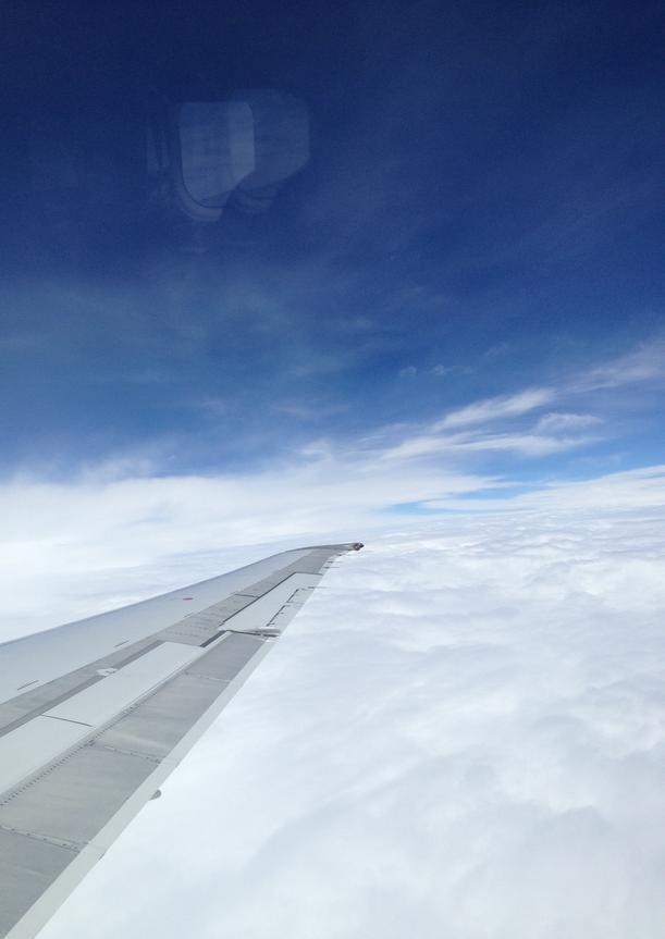
ANDREA From Above
Thanks to my brother-in-law, Aaron Weidner, for the picture below. He was on business out east this week and happened to be flying above ANDREA Thursday as he was on his way home... pretty neat! Thanks Aaron!
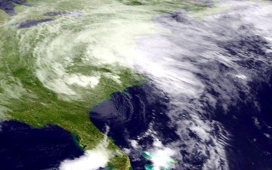
ANDREA Drenches East Coast
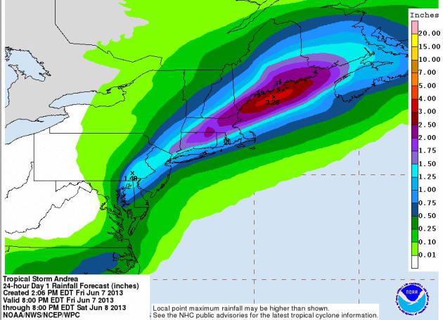
There were 10 tornado reports and several wind damage reports associated with ANDREA, but widespread wind damage has not been the biggest issue. The biggest concern with ANDREA really has been the excessive rainfall; from Floriday to Maine (13 states included) heavy rainfall of some 3" to 6"+ reports may be possible when all is said and done through the weekend.
The image below suggests the radar estimated rainfall from Friday. The red colors indicated 3"+
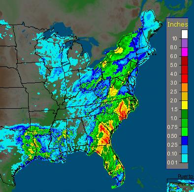
New York Rain
Thanks to my good friend Jamie Steinert for the pictures below from New York City. Looks like ANDREA made for a soggy Friday night out on the town...


Additional ANDREA Rain
As ANDREA picks up speed, there
won't be as big of potential for as heavy or rainfall as what we've
already seen across parts of the Southeast. NOAA's HPC from PM Friday
through PM Saturday suggests the heaviest will be right along the Maine
coast, possibly up to 2" to 3".
Tracking the Tropics...
The National Hurricane Center is
also concentrating on another wave in the Atlantic, but at this point,
it appears there is a low chance of it growing into a tropical cyclone.
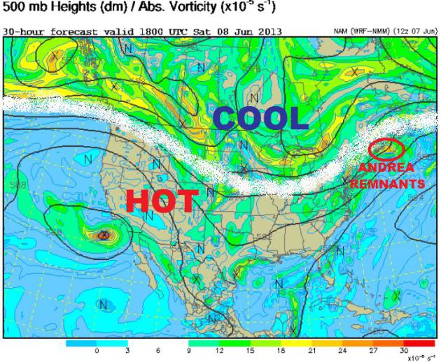
Cool Great Lakes, Hot Southwest
Take a look at the weather map below. The white line shows the placement of the Jet stream, which also divides the warmer air from the cooler air. Note the buckle of cool air over the Great Lakes, but also note the bubble of heat in the Southwest. Temperatures in the Southwest have been nearly record highs in many locations over the past several days and may continue to do so!
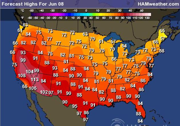
High Temps Saturday
Temperatures in the 100s aren't uncommon in the Southwest, but it's pretty hot out there and it looks like the heat will stick around for much of the next 5 to 7 days!
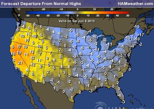
Saturday High Temps From Normal
Temperatures out west are still running 10F to nearly 20F above normal, while temps around the Great Lakes Region are still running a bit below average.
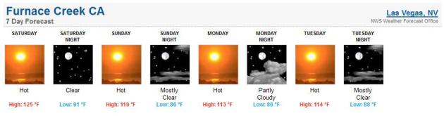
Furnace Creek, CA Temperature Outlook
Take a look at the temperature outlook for Furnace Creek, CA (Death Valley). Saturday appears to be the warmest day of the next 7 days as temperatures soar into the 120s. A nice little cool down in the low 110s is expected into next week... WHEW!
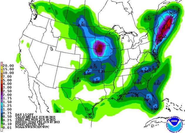
Weekend Precipitation
NOAA's HPC 2 day precipitation forecast suggests how much rainfall may be possible across the nation this weekend. The big blob in the Northeast is thanks to the remnants of ANDREA, but an additional storm system moving into the Midwest will help to produce heavy rainfall potential of 1" to 3".
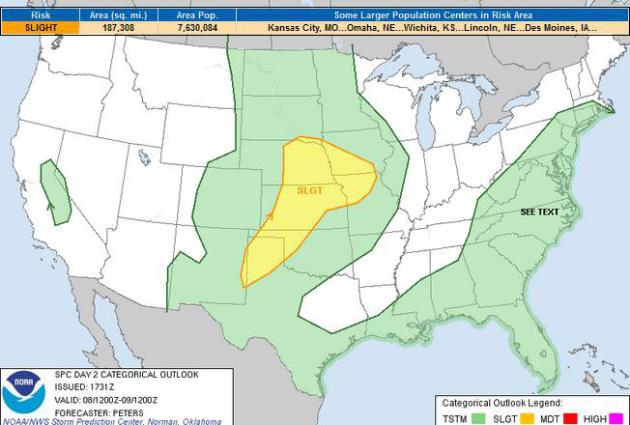
Severe Saturday?
The big blog of precipitation is a response to thunderstorm activity that may be a little more vigorous at times. The Storm Prediction Center has issued a SLIGHT RISK of severe weather for parts of the Midwest and Central Plains on Saturday.
Thanks for checking in, have a great weekend!
Don't forget to follow me on Twitter @TNelsonWNTV