National Light Show
Thunderstorms across parts of the nation have created quite a light show, take a look at some of the spectacular images below.
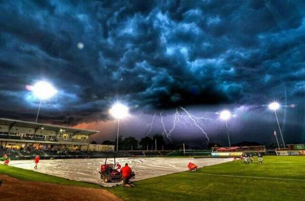
(Photo Below Courtesy: photographer Michael Kitchen via Bowling Green Hot Rods FB page)
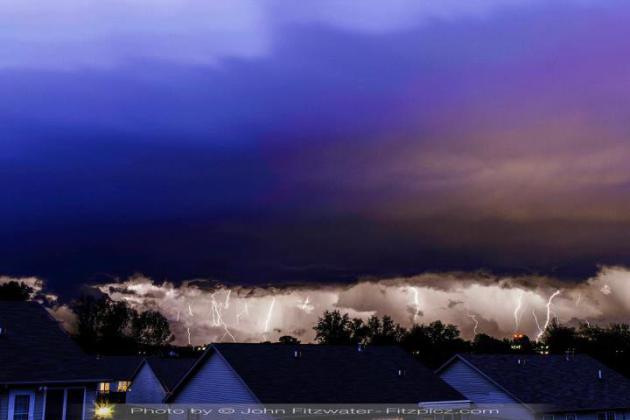
(Photo Below Courtesy: John W. Fitzwater from Somerset, KY)
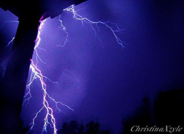
(Photo Below Courtesy: Christina Karnitz from Clarksville, TN)
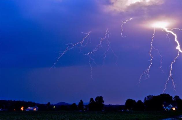
(Photo Below Courtesy: Chad Whitlock from Putney, VT)
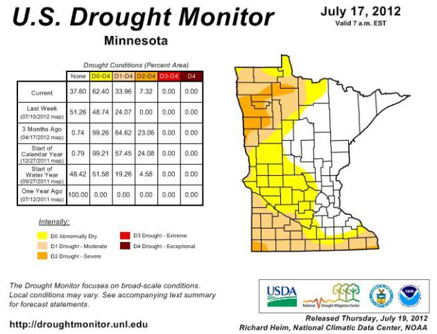
Updated MN Drought Conditions
Every
Thursday the U.S. Drought Monitor releases their newest drought map...
July 19th revealed that 62% of the state was abnormally dry including
parts of the west metro. Nearly 15% more of the state is considered to
be abnormally dry than last week and now even SEVERE DROUGHT conditions
are showing up in far northwestern and far southwestern Minnesota.
Topsoil moisture across 53 percent of Minnesota's landscape is said to be Short or Very Short. The state's corn is now pollinating. Water stress during this critical period of the corn growing season inhibits corn yield potential.
Stream flow measurements at reporting stations in the driest areas of the state rank at or below the 10th percentile when compared with historical data for the date.
The drought situation in northwest Minnesota is the result of a dry autumn, a snow-sparse winter, and a dry growing season (maps below). The moisture deficits in southern Minnesota developed rapidly due to very hot and very dry conditions over the past few weeks (maps below)."
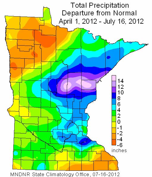
Precipitation From Normal April 1st - July 16th
No
wonder why drought conditions are popping up across the state... take a
look at the total precipitation departure from normal graphic below. It
is indicating that from April 1st - July 16th, some folks in
northwestern Minnesota are nearly 6" behind normal. Meanwhile, the
monster flooding near Duluth, MN in late June has folks there nearly 12"
or more above normal during that time frame.
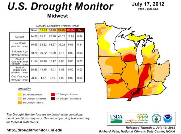
Drought 2012
On
a regional basis, the drought worsens dramatically as you head south...
in fact, there are EXTREME to EXCEPTIONAL drought conditions there. In 3
months, the area below has seen abnormally dry conditions balloon
nearly 45% to almost 86% of the area. 3 months ago, there were no severe
drought conditions (RED) and now there is a 12% coverage area.
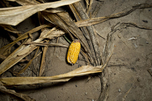
Corn Prices At Record Levels
"The drought, now rated the worst in U.S. history since 1956, has pushed corn prices over the 8$ threshold and soybeans to $17.23 per bushel."
"The
worst drought in a half century will continue to plague most of the
U.S. Midwest crop region for at least the next 10 days, with only
occasional showers providing some relief mainly in the east, an
agricultural meteorologist said on Thursday.
"An
underdeveloped ear of corn lays amongst corn plants damaged by extreme
heat and drought conditions in a field in Carmi, Illinois. The worst
Midwest drought since 1988 is baking farms from Arkansas to Ohio and
boosting the cost of corn used in food for people and livestock at a
time when consumers are already paying the most ever for meat.
Photographer: Daniel Acker/Bloomberg"
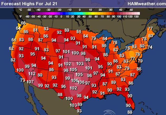
Heat Continues This Weekend
Look
at the high temperature map for Saturday... WHEW! More 90s and 100s,
some may even be at record levels in the central part of the country...
When will it end!
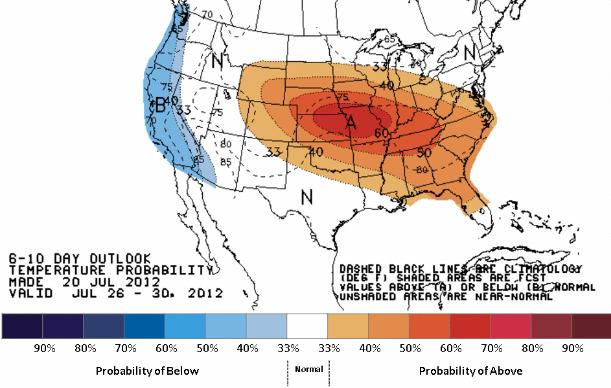
Heat Continues Through July
NOAA's
Climate Prediction Center has a high probability of the above average
temperatures continuing through the end of the month. The 6-10 day
temperature outlook shows a 60% chance of above average temperature
during that time frame centered over Kansas City & St. Louis, MO.
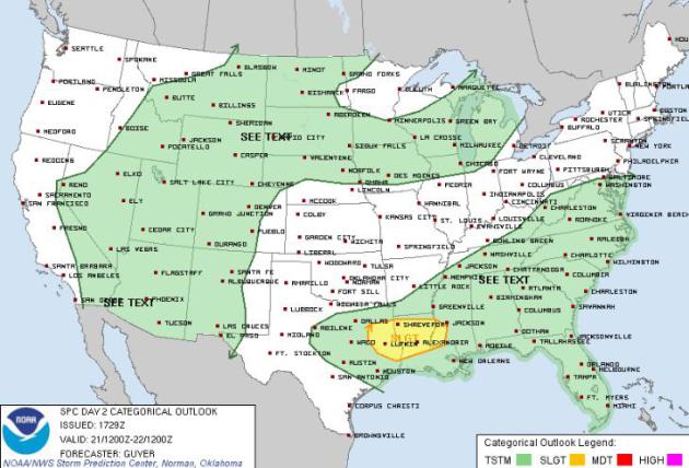
National Severe Weather Threat Saturday
The
Storm Prediction Center has issued a SLIGHT RISK of severe weather for
parts of the Lower Mississippi Valley, but there will be areas of
convection in the green shaded areas, which could tip severe limits as
well. 1" diameter hail and 58mph wind gusts are considered to be
'severe'
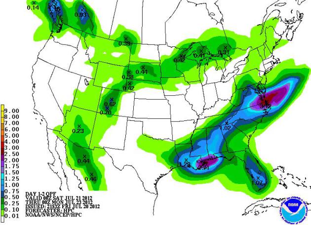
Weekend Precipitation
NOAA's
HPC shows areas of precipitation over the weekend from the Desert
Southwest to the Great Lakes and another swath of heavier rain from the
Lower Mississippi Valley to the Mid-Atlantic State. These areas of
precipitation will come in the form of showers and thunderstorms all
rotating in a clockwise fashion around the bubble of heat in the central
part of the country.
Thanks for checking in, have a great weekend!
Don't forget to follow me on Twitter @TNelsonWNTV