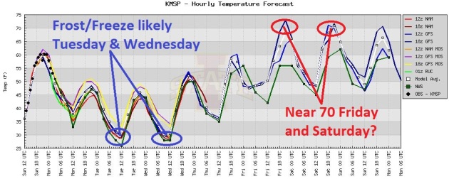
Good Chance Of Frost. After being amazingly uniform (highs within a few degrees of 60 into Saturday) a cold front brings back light jackets early next week; models hinting at the best chance of frost Tuesday morning, another (lesser) risk of 32 F. readings next Wednesday morning.
“The departure from normal for temperatures this past month were just staggering, with most of Minnesota and Wisconsin seeing the average temperature for the entire month end up being double digits above normal.” - from the Twin Cities National Weather Service, from a Climate Central post below. More details: Twin Cities NWS.
Tornado Warning. "One of these days a single tornado will claim over 1,000 American lives." The story I wrote about troubling trends (more violent tornadoes touching down east of the Mississippi, where people aren't as prepared or tornado-wise) is below.
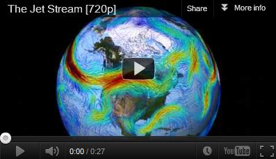
"The jet stream, the study says, is becoming “wavier,” with steeper troughs and higher ridges. Weather systems are progressing more slowly, raising the chances for long-duration extreme events, like droughts, floods, and heat waves." - from a Climate Central story linking changes in the Arctic to warm weather records across the rest of North America. WRF model output source here.
"The 2012 Atlantic hurricane season will be "below average" with 10 tropical storms, four of which will strengthen into hurricanes, Colorado State University forecasters predicted on Wednesday. Two of those will become major hurricanes with winds of at least 111 miles per hour (178 kph)..." - from a Reuters story below. Photo: NASA.
"To Hayhoe, the earth, being "God's second-greatest gift" after Christ himself, is made up of resources given by the creator. But in return, she said, people have produced massive amounts of waste, resulting in an island of plastic garbage in the middle of the Pacific Ocean as big as Texas, despoiled the habitats of millions of species and plants, and created air pollution from burning fossil fuels." - from a story from the Abilene-Reporter News, details below. Photo credit here.
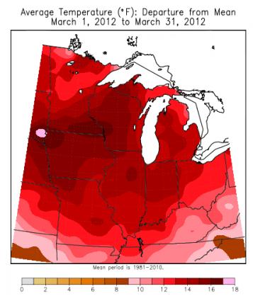
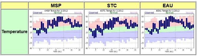
Graphic credit above: "March temperature departures from average during March 2012. Credit: Midwest Regional Climate Center."
Minnesota Climate Highlights. Here's an excerpt from Greg Spoden's latest press release from the Minnesota Climatology Working Group:
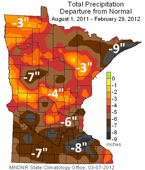
- The U. S. Drought Monitor depicts nearly every Minnesota county as experiencing some level of drought. A large portion of northeast Minnesota is placed in the Severe Drought category. The Drought Monitor also rates much of southern Minnesota in the Severe Drought category. Nearly all other Minnesota locales are determined to be in Moderate Drought. Over the last eight months, precipitation totals are short of normal by more than six inches in many Minnesota communities.
- Without ample, widespread precipitation in April and May, Minnesota will face a number of drought-related issues during the 2012 growing season. The drought situation will become rapidly apparent in the form of wildfire potential, deficient soil moisture supplies, and low water levels in wetlands, lakes, and rivers.
- Monthly mean temperatures for March 2012 were astoundingly warm, topping the historical average by 10 to 17 degrees across Minnesota. It was the six consecutive month of abnormally warm temperatures. Preliminary data indicate that March 2012 will rank as Minnesota's - and the country's - warmest March of the modern record.
- The extraordinarily warm weather rapidly advanced signs of spring such as perennial plant development, agricultural field work, and lake ice out by three to four weeks. For the majority of Minnesota lakes, 2012 ice out dates were the earliest on record.
- The potential for wildfires is currently rated by DNR Forestry as HIGH for nearly all Minnesota counties.
Map credit above: "Nearly all Minnesota counties are designated as undergoing Moderate to Severe drought (map at right). In north central and northeast Minnesota, stream flow and lake levels are very low due to the lingering impact of precipitation deficits during the 2010 growing season and spotty rainfall in 2011. Much of the southern one-third of Minnesota is rated in the Severe drought category. In those areas, significant late-summer and autumn 2011 precipitation shortfalls led to rapidly deteriorating hydrologic conditions. Precipitation totals for the seven-month period from August 2011 through February 2012 were less than seven inches in many areas, a negative departure from the long-term average of four to eight inches (maps below). When compared with the same seven-month period in the historical database, the precipitation totals rank among the lowest on record over a large area of southwest and south central Minnesota." More details from the Minnesota Climatology Group.
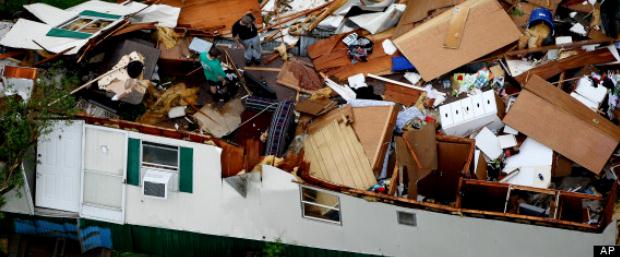
Photo credit above: AP.
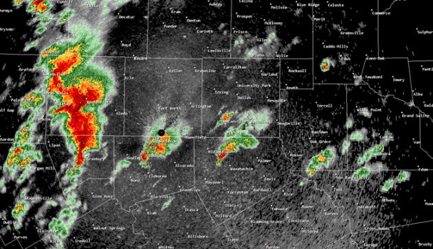
Latest Tornado Count From The Dallas/Ft. Worth National Weather Service. Details: "In addition to the documented tornadoes in Arlington/Kennedale, Lancaster, and Forney, there are two additional documented tornadoes to report. Storm survey teams found evidence of EF-1 damage near Joshua in northern Johnson County. Additionally, there was an EF-2 tornado in Rockwall County south of Royse City. These additional documented tornadoes WILL NOT change our estimate of total tornadoes (that number is still 13), but it does bring our total number of documented tornadoes to 5. Additional information will be sent in the coming days."
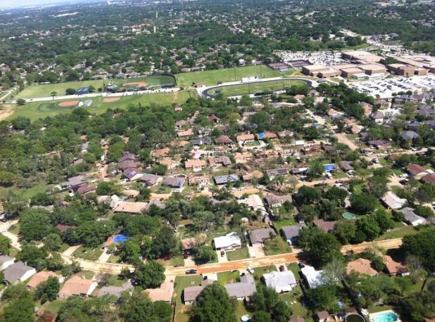
Aerial View Of Damage In Arlington, Texas. Details from the DFW National Weather Service via Facebook: "This is an aerial photograph of a tornado damaged area in Arlington TX. The damage from the tornado that affected Kennedale and Arlington on April 3, 2012 has been given a preliminary rating of EF-2. The photo was taken on Wednesday, April 4, looking to the east."
DFW Storms Had All The Right Ingredients, Including TV Cameras. I have a tough time with this - by showing video of tornadoes on the ground we encourage people (anyone with a smartphone now) to put themselves - potentially - in harm's way. And yet if (a big if) they can do it safely, SEEING footage of a tornado on the ground, from a live stream, a webcam, helicopter video (hope the life insurance is paid up) often is the TRIGGER that gets people to take the tornado warning seriously - to get up off the couch and head to the basement. In a perfect world we would rely on a fixed network of live, streaming webcams (battery back-up, multiple wireless networks for redundancy) and take people out of the equation - but at the rate we're going I doubt that will happen anytime soon. Here's an article from The Star-Telegram: "All the ingredients were on the table, and Mother Nature mixed up a perfect storm of reality TV on Tuesday as tornadoes tossed big rigs into the sky during a mad five-hour march across the Metroplex. "You had pretty much an ideal environment form right over the Dallas-Fort Worth Metroplex that would allow these thunderstorms to acquire deep rotation and produce tornadoes," said Greg Corbin, a meteorologist at the National Weather Service Storm Prediction Center in Norman, Okla. Even as he talked, Corbin was watching video from Dallas-Fort Worth TV stations as the storms danced from town to town in a scary waltz across Texas. When it happened was no surprise. Over the last 60 years, 172 tornadoes have been reported in Dallas and Tarrant counties, and nearly 30 percent have come in April, Corbin said."
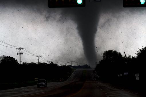
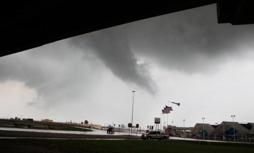
Photo credit above: "A tornado touches down in Lancaster, Texas south of Dallas on Tuesday, April 3, 2012. Tornadoes tore through the Dallas area Tuesday, peeling roofs off homes, tossing big-rig trucks into the air and leaving flattened tractor trailers strewn along highways and parking lots. (AP Photo/The Dallas Morning News, Parrish Velasco)."
Tornado Warning: "One of these days a single tornado will claim over 1,000 American lives." Hype? I don't think so. That quote isn't from me, it's from tornado veteran, meteorologist and Haag Engineer Tim Marshall, who has studied hundreds of tornado outbreaks, and believes that most American homes don't come close to being able to withstand winds from a major or severe tornado. The average home is built to withstand 90 mph winds - not even close to being able to hold up in an EF2 - EF5 tornado. The trends are troubling: more big, violent, long-track tornadoes east of the Mississippi River, where people aren't as prepared as they are in Tornado Alley. It's a combustible mixture - apathy + more (big) tornadoes = recipe for disaster.
I wrote an article for The Huffington Post; here's an excerpt: "Tuesday's 13 large, violent tornadoes in the Dallas were a wake-up call for America. With camera-ready smartphones -- it may have been the most-photographed and filmed tornado outbreak in history -- dramatic video that convinced many locals to take the warnings seriously and take cover. Had the Arlington tornado tracked just 19 miles farther east it would have struck downtown Dallas. A convergence of meteorological and socioeconomic trends has left America more vulnerable to a catastrophic tornado; a single long-lasting tornado hitting a major urban center -- potentially putting thousands of lives at risk. It's too early to know if it's an aberration or a trend -- but in recent years some of the largest, most destructive tornadoes have struck east of the Mississippi River, hitting more densely populated cities and suburbs. There's no clear-cut evidence we're seeing more violent tornadoes, but "Tornado Alley" appears to be expanding north and east. People in Dallas know what to do. Baltimore? Not so much. 2011 brought six EF-5 tornadoes, as big and violent as they get. The movie "Twister" described an F5 as "the finger of God." They are beyond words. Dazed tornado survivors from Joplin to Tuscaloosa are still picking up the pieces of their lives. Their trauma has lessons for the rest of us. Tornadoes bulldozing the eastern U.S. present a unique problem. They're much harder to track (more hills and haze; highways that make chasing tornadoes all but impossible). Many homeowners don't have safe, underground options. Bedrock and high water tables can make it prohibitively expensive to excavate for a basement; the only thing that makes a 200 mph EF-5 super-tornado survivable."
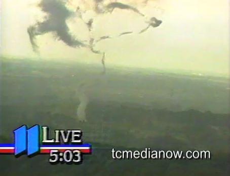
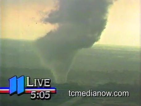
* frame-grabs above courtesy of KARE-11 and tcmedianow.com, showing the infamous 1986 tornado that was photographed by Sky 11. It was proof-positive that tornadoes CAN touch down in heavily-populated metro areas.
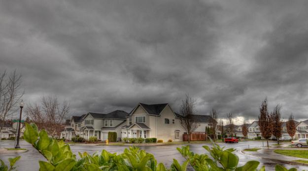
Photo credit here: Mike McCune/Creative Commons
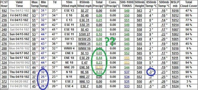
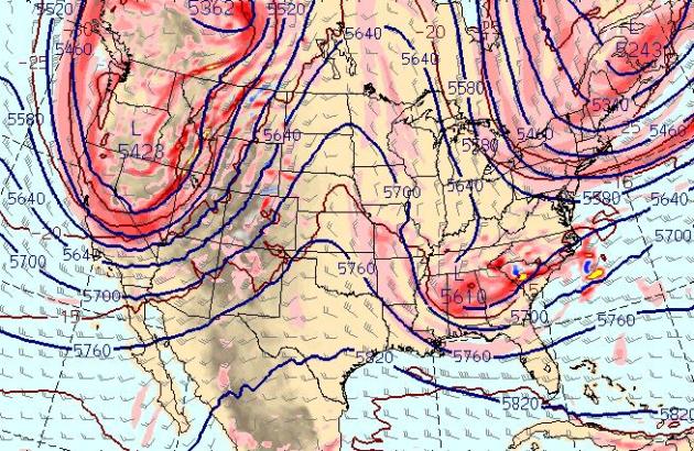
Potential For A Real Storm? Not buying it yet - but it's refreshing seeing significant rain (and...um...a hint of wet snow) on the long-range maps. The GFS is printing out over 1" rain around April 17-18, with 850 temperatures potentially cold enough for rain to end as a little wet snow. Who knows? This is still nearly 2 weeks away, and the GFS has been erratic and unreliable - just as confused as we are. Stay tuned...
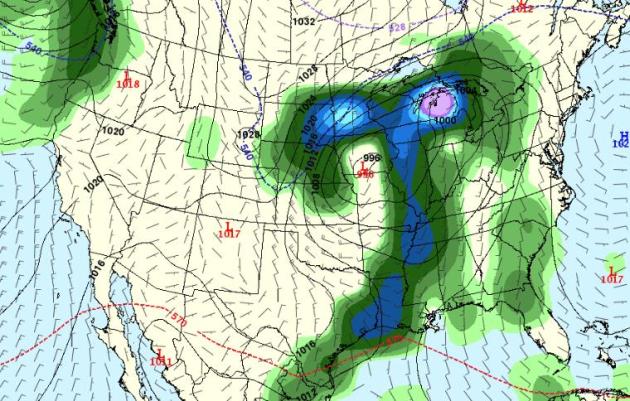
GFS: April 18. Here is the GFS outlook for 18z, on April 18, showing a strong storm over southern Iowa - throwing a cold rain into Minnesota. Temperatures aloft may be marginally cold enough for rain to end as a period of wet s-s-snow, especially north/west of the Twin Cities. It's just too early to know - confidence level is about as low as it gets.
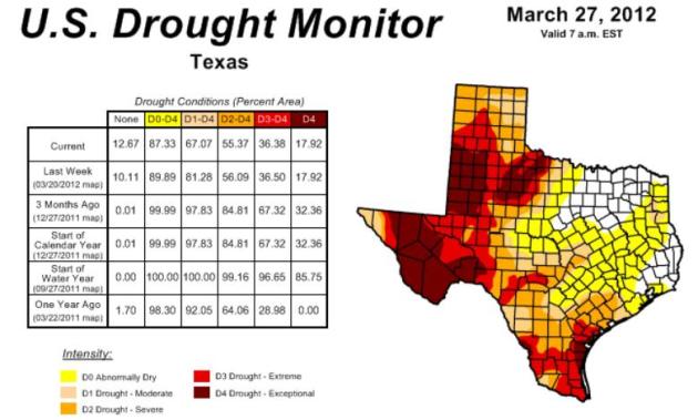
Texas Drought: Wet Winter Doesn't Mean Its Over. Here's an update from The Huffington Post: "SAN ANTONIO (AP) — An unusually wet winter that brought badly needed relief to a state suffering through a historic drought is no guarantee that bone-dry conditions won't return to Texas later this year, the National Weather Service warned state officials Monday. "We're in a positive phase of getting out of the drought," meteorologist Barry Goldsmith said. "But notice I'm mincing my words. We're not out of the woods just yet." Soaking rains since December have saturated parts of Texas with as much as 12 inches more rain than normal for this time of year, injecting color and growth back into browned and brittle landscapes. There should be even more rainfall in April and May across state, Goldsmith said." Map above courtesy of NOAA's Drought Monitor.
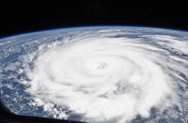
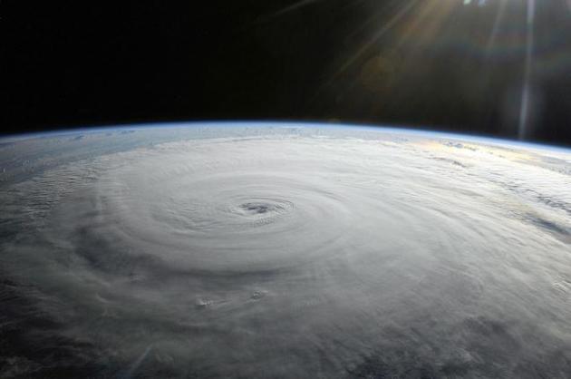
Below Average Hurricane Season Forecast. La Nina is weakening - the "cooling phase" in the Pacific that still, somehow, resulted in the 4th warmest winter on record for the Lower 48 States. Now we're transitioning into a possible El Nino - which correlates with stronger winds over the tropics - winds which tend to shred developing tropical storms. El Nino usually means fewer/weaker hurricanes, but at the rate this year is going - all bets are off. More from Reuters: "The 2012 Atlantic hurricane season will be "below average" with 10 tropical storms, four of which will strengthen into hurricanes, Colorado State University forecasters predicted on Wednesday. Two of those will become major hurricanes with winds of at least 111 miles per hour (178 kph), the team founded by forecasting pioneer William Gray said. In an average year, there are 11 tropical storms, six hurricanes and two major hurricanes in the Atlantic, Caribbean and Gulf of Mexico during the season that runs from June 1 to November 30. The outlook for a milder 2012 season was based on two main factors. Hurricanes thrive on warm water and the tropical Atlantic has cooled this year, the researchers said. There is also a "fairly high" likelihood that an El Nino effect will develop this summer, they said." Photo of Hurricane Igor taken by the ISS, International Space Station on September 14, 2010, courtesy of NASA.
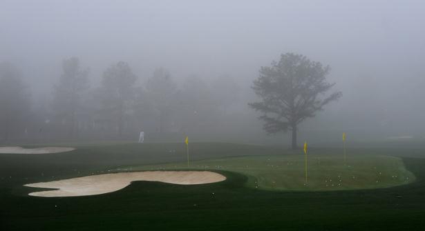
Foul Weather At The Masters. It'll get better as the week goes on (I hope). More from masters.com: "An overnight thunderstorm caused a gate-opening delay at the 76th Masters Tournament on Wednesday morning. At daylight, fog blanketed the Augusta National Golf Club on the final day of Practice Rounds and as the Par 3 Contest was scheduled to take place in the afternoon on the Par 3 Course. The gates were scheduled to open at 8:40 a.m.Cleanup crews were busy on the grounds preparing the course after a storm moved through the Augusta area that brought high winds, heavy rain and hail. After midnight Tuesday, there was more than 1 inch of rain on site.The forecast calls for warm weather today, setting the stage for some isolated showers and thunderstorms in mid-afternoon and evening. Storms are likely by Thursday afternoon into the evening and continuing Friday morning with clearing Friday afternoon. Dry conditions will return this weekend with more seasonable temperatures of highs in the mid-70s."
Hi Paul,
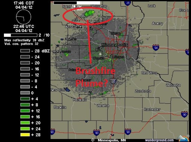
Is this the smoke plume from a grass fire? Showing up on radar, down
by Farmington?
http://preview.tinyurl.com/775ptnq
-- Kai
P.S. You run the best weather blog ever, by the way. I read it every day.
Kai- thank you for being a loyal reader. The older I get the less I take for granted - we appreciate that very much. I used the link you sent near the top of today's blog - yes, I suspect it was a smoke plume from a brushfire in the far north metro. Conditions are tinder-dry and until we get a few good soakings, fire (and dropping lake water levels) will be a growing problem across the state. Thanks for the link!
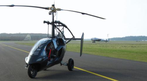
Photo credit above: "The PAL-V at a runway. PalVco/via Flickr."


Mixed Messages
My heart was in my throat Tuesday, as big, violent EF-2 tornadoes were carpet-bombing the Dallas area.<p>It reminded me of a 2002 study, simulating an EF-5 tornado going through the heart of Dallas at rush hour, threatening thousands of lives. A worst-case scenario trapped 87,000 motorists in their cars. Had the Arlington tornado tracked 20 miles farther east it would have hit downtown Dallas; a Katrina-like catastrophe. We got lucky.
I struggle with the messages we're sending to the public. "Go to the basement - don't photograph the tornado!" Then what do we do? We put incredible footage on the air. We talk out of both sides of our mouths. The only possible upside: many people are skeptical and apathetic. "They're crying wolf again Mabel!" Sometimes it takes live tornado video from a webcam, chopper or a guy with an iPhone for people to do the right thing and head to the basement.
Tornadoes or drought? I'm leaning toward drought in 2012. It'll be far too cool for anything severe into next week. A shower is possible Saturday, followed by light jackets early next week. I don't see a widespread freeze (few hours colder than 28 F), but a frost is likely in the suburbs by Tuesday.
Photo credit above: "Storm clouds loom over I-30 and N Buckner Blvd in Dallas during a storm on Tuesday, April 3, 2012. Tornadoes tore through the Dallas area Tuesday, peeling roofs off homes, tossing big-rig trucks into the air and leaving flattened tractor trailers strewn along highways and parking lots. (AP Photo/The Dallas Morning News, Kye R. Lee)."
Climate Stories..
Texas Tornadoes: Climate Change - And Climate Deniers - In The Lonestar State. Here's an excerpt of a story at Huffington Post: "Here's a headline we're tempted to write - or rather, one that we would be tempted to write if we weren't so nice, or so dedicated to avoiding oversimplification: "Climate-Change Deniers Struck by Climate Change in Texas Tornado Outbreak." This week two seemingly unrelated but very connected events took place: In the first, freak tornadoes struck the Dallas area today with unexpected ferocity, causing many experts to revisit the issue of whether tornadoes should be included in the list of extreme weather caused by climate change. In the second, one of the hard-hit area's Representatives bragged about cutting funds for - predicting storms and reducing their impact. If you think that's bad - and it is - last year Mitt Romney did the Representative one better: He said it would be "immoral" to spend Federal money to help victims of national disasters like the one that just struck Texas."
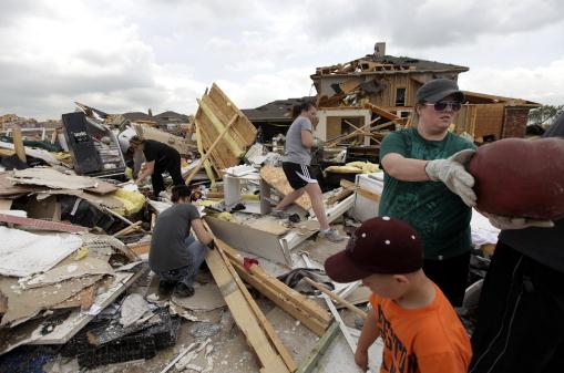
Photo credit above: "Bobbie Deen, right, along with friends and family help salvage personal items from Deen's mothers home Wednesday, April 4, 2012, in Forney, Texas. Deen's mother, Sherry Enochs was babysitting three children Tuesday, all under the age of 3, that survived a tornado that struck the area. The mayor of Forney, Texas, says it's "a real blessing" that nobody was killed in the community by the tornadoes that ripped through parts of the Dallas area yesterday. (AP Photo/Tony Gutierrez)."

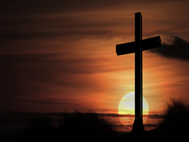
Christian Climatologist Tackles God And Global Warming At Hardin-Simmons University. Here's an excerpt of a story at The Abilene-Reporter News: "In the Book of Revelation, Christian believers are promised, along with the return of Christ, a new heaven and a new earth, But Christian climatologist Katharine Hayhoe said in an interview Tuesday that until the promise is fulfilled believers in the here and now aren't excused from tending the planetary garden granted them. "It may happen any day, but we don't know when it is," she said on the topic of Christ's expected return. So in the meantime? "Make wise choices," said Hayhoe. The associate professor of atmospheric sciences at Texas Tech University spoke to Hardin-Simmons University students and others Tuesday on climate change and her role as director of the Climate Science Center at Tech. To Hayhoe, the earth, being "God's second-greatest gift" after Christ himself, is made up of resources given by the creator." Photo: American Meteorological Society.
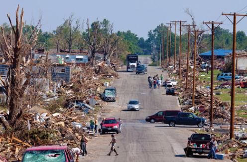
Photo credit above: "Volunteers and debris fill the streets of Joplin, Missouri, after an EF-5 tornado touched down on May 22, 2011."
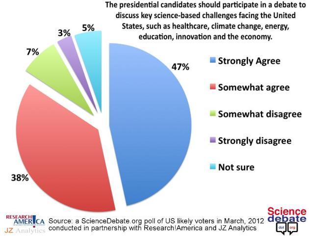
New Poll: Even Religious Voters Overwhelming Want Candidates To Debate Science. I've said this over and over, ad nauseum: I'm a Christian. No matter what you believe all of us ultimately come to our God through faith - but in matters of climate science no faith is required. There's plenty of peer-reviewed scientific evidence, for people that take time to dig in - and avoid talk radio and denier-troll-sites that revel in cherry-picking to advance their agenda. Here's an excerpt of an interesting post at Neorennaisance: "Whenever the people are well informed," Thomas Jefferson wrote, "they can be trusted with their own government." But what happens now, two centuries later, when science has become so complex and so powerful that it influences every aspect of life, while most politicians' last science class was in high school? Are the people still well-enough informed to be trusted with their own government? This is the subject of my new book, Fool Me Twice. But it's also the subject of a larger conflict over the nature and role of government, and the role of science as the best basis for determining public policy that is fairest to all Americans. Every major policy challenge the United States is facing today is either wholly or partly driven by science, and yet this year in particular we have seen every mainstream candidate for president adopt one or more positions that run contrary to the best available evidence science has to offer."
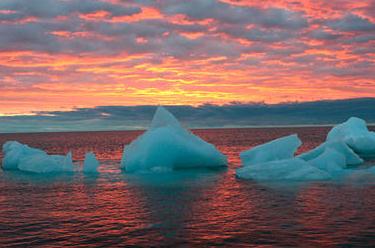
Increasing Carbon Dioxide Levels Ended Last Ice Age. Here's an excerpt from an article at The Christian Science Monitor: "Planet-warming carbon dioxide emissions - similar to those caused by burning fossil fuels and other human activities now - helped heat the planet and end the last ice age some 11,700 years ago, scientists reported on Wednesday. In a finding that offers a response to those skeptical about human-caused global warming, researchers from Harvard University, Oregon State University and other institutions reported in the journal Nature that rising temperatures followed increases in carbon dioxide. Climate scientists had long suspected this was the case, but the geologic record was murky. Earlier studies looked at air bubbles trapped in ancient ice in Antarctica that revealed carbon dioxide levels in the late Pleistocene Epoch, some 20,000 to 10,000 years ago, the period when the ice age tapered off."
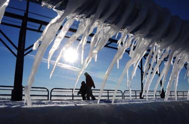
Photo credit above: "Layers of ice and icicles slowly melt along the North Pier in St. Joseph, Mich. on Saturday, Jan 21, 2012. In an attempt to understand global melting, a new study shows that the end of the last ice age was preceded by an increase in carbon dioxide emissions. AP Photo/The Herald-Palladium, Don Campbell."
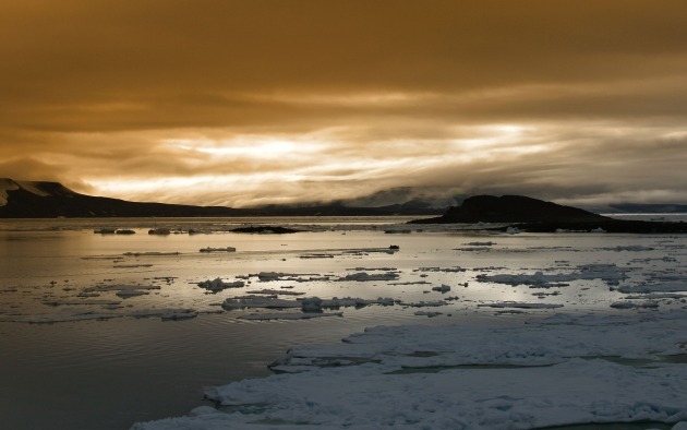
Did Melting Antarctic Permafrost Drive Ancient Global Warming? The story from ScienceNOW: "Fifty-five million years ago, the world abruptly warmed by a scorching 5 degrees Celsius, the oceans turned acidic, and life ran a gantlet of extinction. Sound familiar? That was the closest nature ever came to foreshadowing the fossil-fuel-fed warming that is just getting underway now. But for 15 years, climate scientists have puzzled over how that ancient global warming could have happened. Now a group of researchers is offering a new explanation: The needed greenhouse gases could have gushed from thawing permafrost on an ice-free Antarctica."
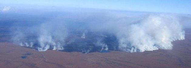
Photo credit above: "Up in smoke. A sudden global warming 55 million years ago might have been fueled by carbon dioxide released from permafrost, as happened in Alaskan fires in 2007. Credit: Bureau of Land Management/Alaska Fire Service."

Global Warming May Bring More Lyme Disease, Ticks. Great - just what you want to dig into on a Thursday. Hey, I'm just the messenger - the gory details from Huffington Post: "Darren Collins doesn't know life without Lyme disease. He was just 11 months old when he came home from Wisconsin's Mauthe Lake Campground pasty white, lethargic and running a fever of 105. Darren's flu-like illness eventually subsided, but a host of other troubling Lyme-related symptoms -- stomachaches, irritability and concentration problems -- have since plagued the boy, now 10. "He's like Jekyll and Hyde," says his mom, Kristin. One moment Darren could be "happy and smiling," and the next in a "complete rage." "He scores perfect on a spelling test one week, then gets every word wrong the next week," adds Kristin, a nurse in Waukesha, Wisc. "He wants to know why he can't be like other kids." Photo credit: Wikipedia.
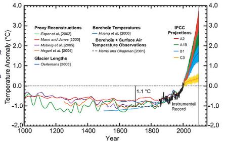
Get Your Own Hockey Stick. Here's an interesting post at getenergysmartnow.com: "Want to prod an anti-science syndrome sufferer into a vitriolic rampage, utter two words: “hockey stick”. And, want to see them turn red, add two more words: “Michael Mann”. Simply put, Dr. Michael Mann’s work on reconstructing temperature records using multiple sources provided a very telling demonstration of how (rapidly mounting) modern temperatures were entering ranges simply not seen over (at least) the past 1000 years. Legitimate climate skeptics had wondered whether modern temperatures were really out of whack with recent (past several thousand years or so) global temperatures, with the Medieval Warming Period (MWP) being the most prominent reason for questioning whether late 20th Century temperatures were really something unusual."
Research Brings New Understanding To Past Global Warming Events. The story from R&D Mag: "A series of global warming events called hyperthermals that occurred more than 50 million years ago had a similar origin to a much larger hyperthermal of the period, the Pelaeocene-Eocene Thermal Maximum (PETM), new research has found. The findings, published online in Nature Geoscience, represent a breakthrough in understanding the major "burp" of carbon, equivalent to burning the entire reservoir of fossil fuels on Earth, that occurred during the PETM. "As geologists, it unnerves us that we don't know where this huge amount of carbon released in the PETM comes from," says Will Clyde, associate professor of Earth sciences at the University of New Hampshire and a co-author on the paper. "This is the first breakthrough we've had in a long time. It gives us a new understanding of the PETM." The work confirms that the PETM was not a unique event—the result, perhaps, of a meteorite strike—but a natural part of the Earth's carbon cycle."

Republican Environmental Group Drops "Republican" From Its Name. From Huffington Post: "WASHINGTON -- After 16 years of trying to marry their party's support for drilling and climate change denial with environmental protection, Republicans for Environmental Protection is dropping the word "Republican" from its name. The group's new name, ConservAmerica, is designed to "explain the connection between conservatism and conservation" and underscore the group's ethic of stewardship. "Our mission is staying exactly the same," said David Jenkins, the group's vice president for government affairs. "It's more of an emphasis issue, switching from the emphasis being on Republican -- not that we're separating ourselves from that at all. It's just putting the emphasis more on connecting conservation and conservative, which are born of the same root."
Sociology Professor Draws Limbaugh's Fire. Here's an excerpt of a story at registerguard.com: "University of Oregon professor Kari Norgaard had the honor last week of taking part in a panel discussion in London at a prestigious meeting of scientists on the subject of climate change. But upon her return, she found her name on Rush Limbaugh’s lips, her university e-mail stuffed with hundreds of hateful messages and the UO itself under attack in the blogosphere for “Stalinesque” changes to its website. “Maybe they’ll soon go from being called The Mighty Ducks to ‘The Mighty Schmucks,’ ” one of the bloggers wrote. The subject of the bloggers’ ire appears to have sprung from an inaccurate description of Norgaard’s work that appeared in a UO news release. It said: “Resistance at individual and societal levels must be recognized and treated before real action can be taken to effectively address threats facing the planet from human-caused contributions to climate change.”
Scientists Push To Change Timing Of Seasons. Yes, this is satire. I think. Here's an excerpt from EarthAirWaves: "SANTA FE, NM – Local skiers were festive but disappointed on closing day, a full week earlier than originally planned. As temperatures in the state capital approached 80 degrees on the first day of April, rivulets of water cascaded into the ski area parking lots. Large patches of bare ground were exposed along with bare skin of skiers and snowboarders who occupied Totamoff’s deck to enjoy the sun and beer. “When I first came to Santa Fe, it always snowed by Halloween and the ski area always opened by the end of November,” observed Michael Wigley, a local skiing legend. “Now we are lucky if we have decent snow before Christmas. Scientists and meteorologists have voiced growing concerns that the winter season is disappearing across much of the northern hemisphere. Dr. Jeff Masters put it bluntly on his blog, “Mother Nature has fast-forwarded past spring and gone straight to summer over the Midwest.”