 1,400
1,400. Average number of tornadoes every year across America. Fewer than 1% will reach EF-4 or EF-5 strength.
13 minutes. Average lead time for a tornado in the USA (time from when a warning is issued until arrival).
6-7 minutes. Average lead time in 1975.
+2.5 F. Water temperatures in the Gulf of Mexico were 2.5F warmer than average in March, the mildest ever observed. Meteorologists are concerned that this added warmth and moisture over the Gulf may be a factor in what is turning into an especially severe tornado season across the USA. Details below.
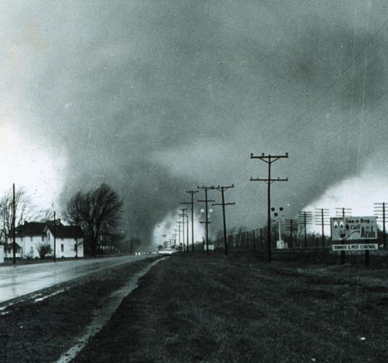
* photo above of the April 11, 1965 Palm Sunday tornado outbreak courtesy of NOAA. Details from
Wikipedia.
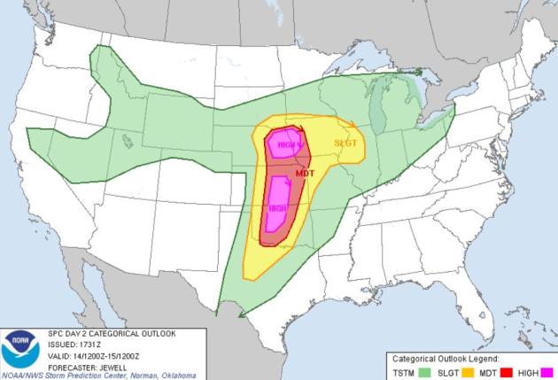
"High Risk" For Tornado Alley. A "high" risk 2 days out? This has happened only one other time in the modern history of the product usage. The only other time
NOAA's SPC issued a "high threat" 2 days out was April 7, 2006. The subsequent outbreak spawned 73 tornadoes, killing 13 people, sparking $1.5 billion in damage. SPC has modified the area where large, violent tornadoes are anticipated:
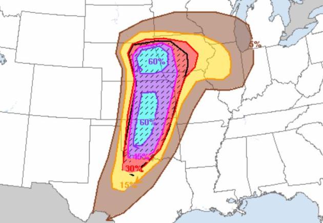
one high threat area from near Oklahoma City northward to Wichita, another high risk area over eastern Nebraska and western Iowa. The meteorologists I
trust who specialize in tornado forecasting are most concerned about the northern area, closer to the "triple point" and vigorous boundaries that may help to spin up the wind profile favorable for EF-3+ tornadoes later today. The hatched area in the upper right is the probability of severe weather within 25 miles of any point - 60% is off the scale. This could be the biggest outbreak of the year - or certainly in the Top 3. The only saving grace:
it's coming in the heart of Tornado Alley, where most people know what to do if a tornado is approaching. I just pray that no major cities are impacted.
April 7, 2006
EF-3 tornadoes: 2
EF-2 tornadoes: 5
EF-1 tornadoes: 25
EF-0 tornadoes: 41
Major Population Centers In Or Near High Threat Area:
Des Moines: 200,538 (city only)
Omaha: 454,731
Lincoln, Nebraska: 254,001
Oklahoma City: 579,999. 2010 census.
Wichita: 2011, the metro area had a population of 630,721.
Norman, OK: - With a population of 110,925 as of the 2010 census
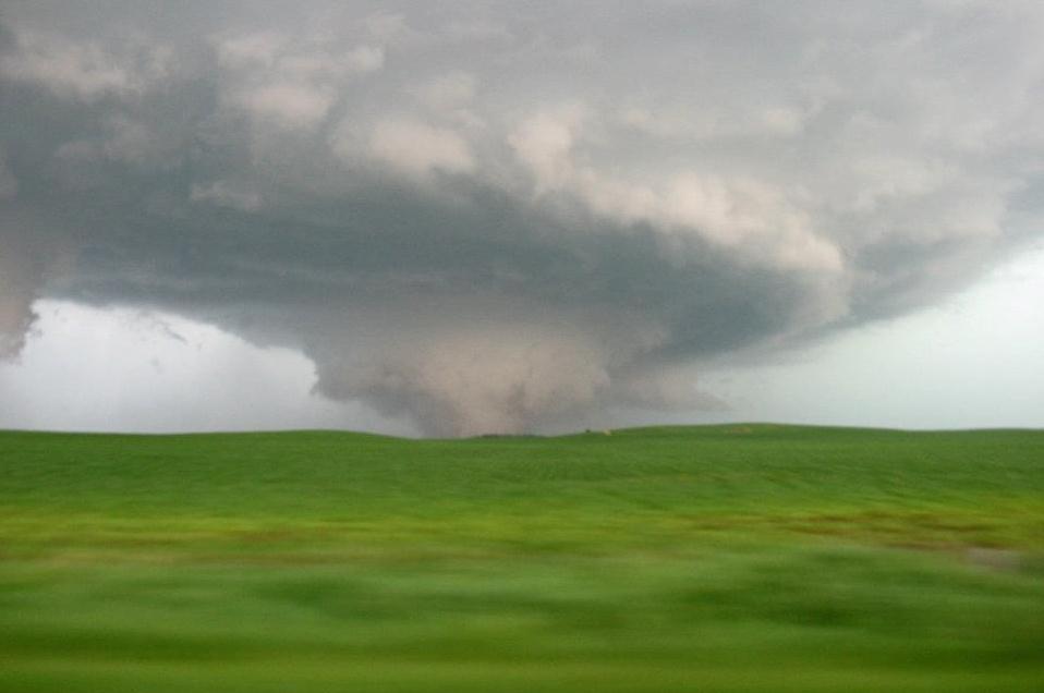
Potential For A Major Tornado Tragedy. We've been (very) lucky that a major tornado has not hit a heavily populated area in Tornado Alley recently. Meteorologically - there is nothing preventing a large, violent tornado from hitting a close-in suburb or even a downtown. Here's a recent story I wrote for Huffington Post, highlighting the potential for a major loss of life from a "wedge" striking a major population center. Tim Marshall, a meteorologist and structural engineer, recently warned "there will be 1,000 or more deaths from a single tornado hitting a major population center in the near future." I hope he's wrong - but, like many meteorologists, I'm worried about complacency and apathy. You'd be amazed at the number of otherwise logical people who believe living in a city insulates them from tornadoes. Nothing could be farther from the truth. June 17, 2010 Albert Lea tornado courtesy of WeatherNation TV meteorologist Aaron Shaffer.
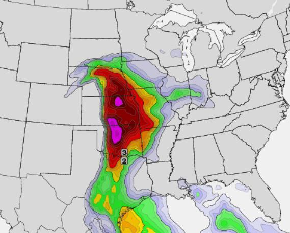
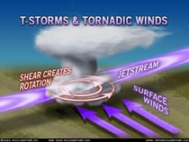
Potential Super-Outbreak Later Today - Forecast EHI Values. EHI is short for "Energy Helicity Index, a combination of the two most important factors in tornadogenesis: buoyancy and shear. Buoyancy is the potential for a parcel of air to rise, and accelerate, a measure of instability. Shear is the integrated difference in wind speed/direction with altitude. If winds at the surface are blowing from the east, 3,000 feet above the ground howling from the south, and 20,000 feet screaming from the southwest at over 115 mph (as the case will be today over the southern and central Plains) thunderstorms can become "supercellular", start to spin, protecting the warm, updraft from rain and hail-cooled air.
"Tornadogenesis" Although the exact mechanism is still unclear, meteorologists theorize that a (warm/buoyant) downdraft, called an RFD, or rear-flank downdraft, wrapping around a spinning supercell, may be the mechanism that focuses horizontal wind shear about a vertical axis, stretching the rotating, violently rising column of air within a severe thunderstorm into a tight vortex, the tornado signature. The map above is from
twisterdata.com, valid at 7 pm this evening.
I'm most concerned about Omaha, Lincoln, Sioux City, even the suburbs of Des Moines - best chance of a few large, violent tornadoes between 5 pm and 9 pm this evening.
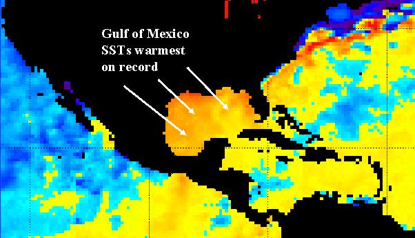
Dangerous Tornado Outbreak Expected Saturday; Gulf of Mexico SST's Warmest On Record. Here's an excerpt from Jeff Master's
Wunderblog - he points out record warm water temperatures in the Gulf of Mexico: "
Temperatures in the states bordering the Gulf of Mexico were the 3rd - 7th warmest on record during the first three months of 2012, according to NOAA's National Climatic Data Center. This allowed Sea Surface Temperatures (SSTs) in the Gulf of Mexico (25 - 30°N, 85 - 90°W) to climb to 1.4°C (2.5°F) above average during March 2012, according to a wunderground analysis of the Hadley Centre SST data set. This is the warmest March value on record for the Gulf of Mexico, going back over a century of record keeping."
Map credit above: "
Departure of Sea Surface Temperature (SST) from average for April 12, 2012, as computed by NOAA/NESDIS. SSTs in the Gulf of Mexico are at their warmest levels on record for this time of year. Follow Weather Underground on twitter for the latest on this potential severe weather outbreak."
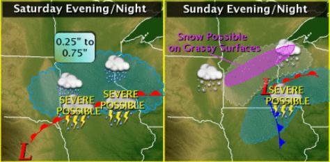 Minnesota Severe Threat
. The greatest risk of severe storms (large hail, damaging straight-line winds and even an isolated tornado or two) will come over southern Minnesota later today, far southeastern Minnesota Sunday PM hours. Source:
MSP National Weather Service office.
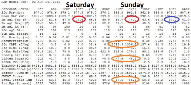 Raw Numbers: Sunday Looks Like The Noisier Day.
 The atmosphere may be stable enough today (lifted indices around +3 to +5) for intervals of sun, low to mid 70s - probably thunder-free until tonight. Early Sunday could be lively though, CAPE over 1,000, lifted indices drop to -8 (anything under 0 is "unstable") with a Total Totals of 57 at 7am Sunday morning. Check out the 2 meter temperature Monday morning at 7am: 32 F. Good grief. A coating of slush can't be ruled out, especially over the northern suburbs, Monday morning. Have a super day!
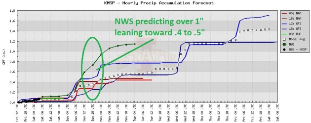 Projected Rainfall.
 The NWS is predicting over 1" of rain by Sunday night, which is possible, especially far southern Minnesota. Here in the metro I'm leaning more toward .4 or .5".
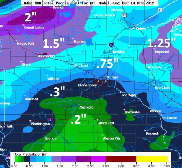 Statewide Rainfall Predictions.
 Heavier rain is predicted by the NAM
model north/west of MSP, as much as 1.5" forecast near Alexandria and Brainerd, with 2" amounts near Detroit Lakes. We'll see - hope the model is right.
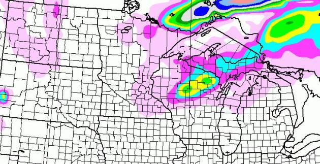
 A Touch Of ....Snow?
 The latest NAM model (00z) prints out some 2-5" snowfall amounts from east of Eau Claire to Rhinelander, Wisconsin, maybe a coating of slush between MSP
and Duluth. There's a good chance we'll wake up to flurries Monday morning - but with warm ground temperatures nothing will stick. I pray.
 Mostly-Mild Last Week Of April
. The GFS pulls the mercury into the 60s and 60s from April 22 to April 28, followed by one more risk of frost around April 28-29. We'll see.
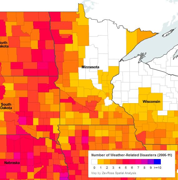
Learn About Extreme Weather's Local Impact. Based on the last 6-7 years I'm thinking of moving to northeastern Minnesota, where there have been NO major weather-related disasters. Why is this? All I can think is that a persistently chilly wind off Lake Superior inoculates much of the Northland for large, violent tornadoes and tends to dampen many of the most severe T-storms. Details from
Environment Minnesota.
"Click on your county to see a tally of weather-related disasters since 2006. Extreme weather is happening—and it's causing extremely big problems. To make matters worse, global warming increases the likelihood that we'll see even more extreme weather in the future. To tackle this threat, we must cut the carbon pollution from power plants, cars and trucks, and other sources that fuels global warming."
Monday S-S-S-now? Here's the latest NAM model, showing accumulated snowfall by Monday evening, a stripe of 2-9" stretching from Wadena and Crosslake to Duluth - heaviest amounts forecast to be along the North Shore of Lake Superior. We'll see. Map from
policlimate.com.
Dry Start To Growing Season. Here's an excerpt from Dr. Mark Seeley's
Friday WeatherTalk blog: "With field working season underway, and some of the state's 2012 crops already in the ground many Minnesota farmers are waiting for rain to replenish the dry soils that were a carryover from last year. The precipitation deficiency reported by some climate observers is very significant. There are many areas of the state that have reported precipitation totals since last August (a period of 8.5 months) that are more than 7 inches behind normal values for the period. Some of these locations are in the list below, showing how the deficiency for this 8.5 month period ranks historically.
Location; Precipitation Total; Departure from Normal; Historical Rank
(8/1/2011-4/11/2012); (8/1/2011-4/11/2012);
Lamberton; 5.35 inches; -7.51 inches; Driest of record
Winnebago; 8.03 inches; -7.17 inches; Driest of record
Marshall; 4.66 inches; -8.69 inches; 2nd Driest
Granite Falls; 4.89 inches; -7.82 inches; 3rd Driest
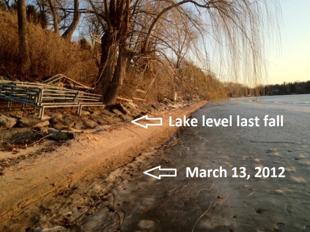
Lake Minnetonka Conservation District Initiates "Low Water Declaration". I know I should have gone into propeller repair (or the dock business). Plan on a few extra dock sections this summer, whatever lake you're hanging out on. More from LMCD: "
When Lake levels fall below 928.0 feet, the Lake Minnetonka Conservation District (LMCD) Code states that the Board of Directors may approve a resolution that allows for temporary dock length extensions for licensed (multiple dock facilities) and unlicensed (primarily residential) sites on Lake Minnetonka. The LMCD Board of Directors has been considering this matter based on water level readings provided by the Minnehaha Creek Watershed District since mid-March, as well as projected precipitation. Based on those findings, a resolution was adopted at the April 11th Regular LMCD Board Meeting declaring “Low Water” on Lake Minnetonka. This resolution authorizes temporary dock extensions per LMCD Code." (I snapped this photo back on March 13).
Kansas Storm Chaser/Photographer Sues Over Montana Wreck Of SUV. When I'm chasing tornadoes (think of how insane that sounds) I'm not so much worried about the tornado. I am worried about hail, cloud to ground lightning, and getting creamed by a guy in a pickup driving 100 mph to catch up to a supercell. I'm amazed there haven't been any fatal accidents, to date. But
dodgeglobe.com has a cautionary tale about the perils of taking your favorite vehicle into Tornado Alley: "
A Kansas storm chaser and photographer is suing a motorist whose car struck his SUV during a Montana snowstorm, alleging that the wreck destroyed a vehicle that had "unique value" for surviving more than 350,000 miles through hurricanes, tornadoes and other extreme weather. Jim Reed of Wichita, Kan., filed the lawsuit April 6 in Helena against an East Helena man involved in the November 2010 crash. He is seeking unspecified compensation for his cranberry-colored SUV and his injuries, the Independent Record (http://bit.ly/HDLgyQ ) reported Thursday. Reed said his 1994 Ford Explorer was featured in much of his work, including a two-page spread in the June 2009 issue of National Geographic, and in a 2009 series on the Speed Channel."
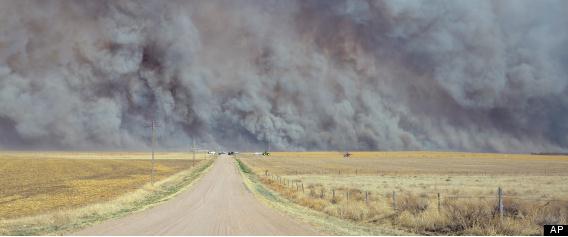
2012 Wildfire Season: States Prepare For Dangerous Fires. It is a bit troubling that we're seeing so many fires so early in the season. Our fast-forward spring has accelerated the frequency and intensity of wildfires and forest fires. It may be a long, hot (and fiery) summer for much of the western USA.
Huffington Post reports: "
DENVER -- The West's 2012 wildfire season exploded in earnest last month with a wind-whipped blaze that killed three people in rugged alpine canyon country near Denver. It took a 700-strong federal firefighting team a week of labor, day and night, to tame the blaze – and other states throughout the West took notice. Fire experts say this year's drought, low snowpack and record-high temperatures in much of the West portend a dangerous installment of what has become a year-round wildfire threat. Wildfires burned more than 1,500 square miles in Arizona last year and have already torched about 12 square miles this year. Most were caused by people, and fire officials hope the public has learned some lessons from the Wallow Fire, the worst in state history. Campfire embers ignited a blaze that forced nearly 10,000 people to evacuate their homes." Photo above courtesy of AP.
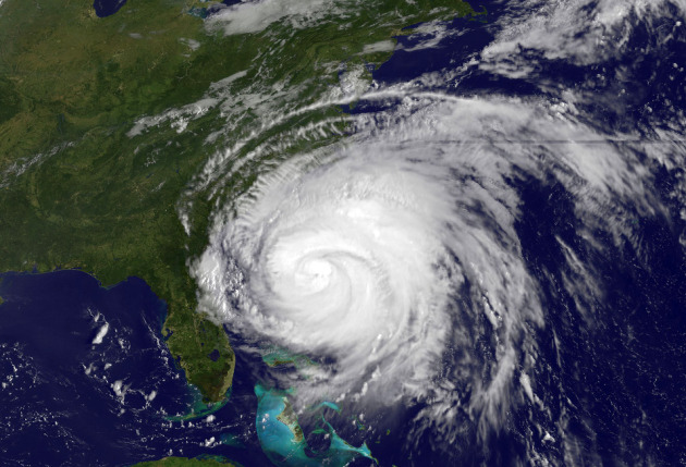
"Irene" Retired From List Of Atlantic Basin Storm Names. From NOAA: "
Irene has been retired from the official list of Atlantic Basin tropical storm names by the World Meteorological Organization’s (WMO) hurricane committee because of the fatalities and damage it caused in August 2011 and will be replaced by Irma. Storm names are reused every six years for both the Atlantic Basin and eastern North Pacific Basin, unless retired for causing a considerable about of casualties or damage. Irene is the 76th name to be retired from the Atlantic list since 1954. Irene became a hurricane on Aug. 22 and intensified to a Category 3 hurricane on the Saffir-Simpson Hurricane Wind Scale on Aug. 24 while centered between Mayaguana and Grand Inagua in the Bahamas. It gradually weakened after crossing the Bahamas, making landfall in North Carolina on Aug. 27 as a Category 1 hurricane. Irene made another landfall the next day as a tropical storm very near Atlantic City, New Jersey. The center moved over Coney Island and Manhattan, New York, the same day." Hurricane Irene image courtesy of NASA.
Irene Replaced By Irma On Atlantic Hurricane Name List.
Nola.com in New Orleans has a slightly different perspective on the "retirement" of Irene's name from the master list; here's an excerpt: "
The World Meteorological Organization has dropped Irene from its six-year list of names for tropical storms and hurricanes because of the fatalities and damage caused by Hurricane Irene last August. Irma will replace it on the list, and could be first used in 2017. Irene is the 76th name to be retired from the Atlantic list since 1954."
Thailand's Blueprint To Reign In Fallout From Floods And Drought. An interesting story from
The Christian Science Monitor; here's an excerpt: "
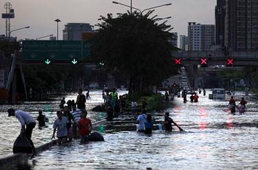
Despite seeing his 60 acres of rice paddies covered in more than 10 feet of water for three months during late 2011, farmer Tawee Wongsan is sanguine about flooding this year. “I don't think there will be flooding this year,” he says. “The water in the big dams is not so high like last year.” Last year's floods killed more than 800 people and caused an estimated $40 billion damage to the country's $345 billion economy, which is the world's 25th largest. Water covered several districts of Bangkok and swamped industrial zones that include vital automobile and electronics sectors, disrupting global supply chains."
Photo credit above: "
Thai residents wade through floodwaters in Bangkok, Thailand, in this October 2011 file photo. Altaf Qadri/AP/File."
Local Earth Day Activities. Earth Day is next Sunday, April 22.
Here is a list of local events, courtesy of
The Will Steger Foundation.
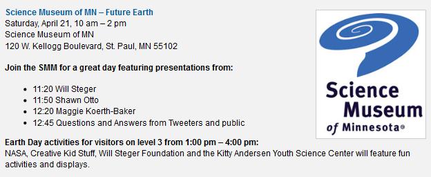
New "Future Earth" Exhibit At St. Paul Science Museum Opens Next Saturday, April 21. This will be a must-see exhibit, and there's added incentive to attend the Grand Opening a week from today. Details from
The Science Museum: "
What will Earth be like in 2050 with 9 billion people? No one knows. But as the healthiest, wealthiest, most educated and most connected population in Earth's history, we're in a good position to face the challenges ahead. Join us in exploring Future Earth!
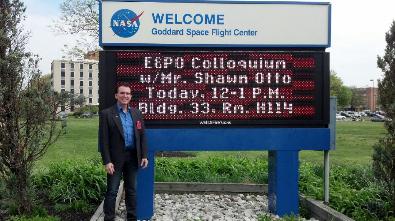
On Saturday, April 21, help us celebrate Earth Day and the opening of Future Earth! From 11 a.m. to 1 p.m., you can hear free presentations by polar explorer Will Steger; Shawn Otto, science advocate and author of Fool Me Twice: Fighting the Assault on Science in America, and Maggie Koerth-Baker, writer and science editor at boingboing.net. And from 1-4 p.m. join in on hands-on family activities with Creative Kidstuff and NASA's Earth Ambassadors."
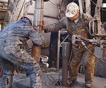
The 10 Worst Jobs Of 2011. What in God's name is a "roustabout"? You're about to find out. This list is making news. Is your job in the Top 10? More from careercast.com: "
From bad to worse: thanks to upheaval in the oil industry, Roustabout ranks as the Worst Job of 2011 – its second straight year in last place. Twelve-hour shifts, exposure to the elements in hostile environments, low pay, high risk of injury and isolation from loved ones for weeks at a time are just some of the factors that combine to make Roustabout the worst job of 2011. As the key providers of maintenance for oil rigs and pipelines, Roustabouts routinely perform backbreaking labor at all hours of the day and night in conditions that can range from arctic winters to desert summers to ocean storms. They even face the threat of attack in unstable parts of the world. Braving these inhospitable surroundings, Roustabouts work on the front lines, getting hands-on with dangerous drilling equipment and risking serious injury or worse – as last year’s explosion at the Deepwater Horizon facility in the Gulf of Mexico illustrates. Why does Roustabout rank as the worst job of 2011, as opposed to other worst jobs such as Lumberjack or Construction Worker? Surveying 200 different jobs, the Jobs Rated report ranks professions according to five core criteria: Work Environment, Physical Demands, Outlook, Income and Stress."
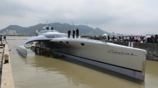
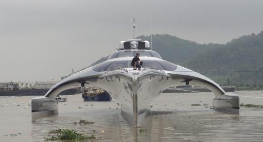
"Astrada" Superyacht Launches In China. How long before one of these shows up on the St. Croix River?
Gizmag.com has the decadent details: "....
The finished product is worth US$15 million, and will likely be used by Marden and his wife Elaine to sail between two islands that they own off the coast of Indonesia. The trimaran measures 42.5 by 16 meters (139.5 by 52.5 feet), and weighs 52 tons (47 tonnes). It has a top speed of 22.5 knots, although at 17 knots it has a remarkable range of 4,000 nautical miles (7,408 km) – this comes thanks largely to a lightweight hull made from a glass/Kevlar foam sandwich material, a superstructure made from carbon fiber with a honeycomb core, and other weight-saving and streamlining considerations. Its fuel economy is estimated at 90 liters (24 U.S. gallons) per hour at 13 knots, or 120 liters (32 gallons) per hour at 17 knots."
Hi Roger. It's Me, Joe: The "Fox Mole". It's fascinating what some publications will do for a scoop; details from
gawker.com: "
Hi. My name is Joe Muto. I was the Fox Mole. Two hours ago I was called into a meeting with Dianne Brandi, the Fox News Executive Vice President of Legal and Business Affairs and suspended indefinitely... with pay, oddly enough. They nailed me. In the end, it was the digital trail that gave me away. They knew that someone, using my computer login, had accessed the sources for two videos that ended up on Gawker over the past few weeks. They couldn't prove it entirely, but I was pretty much the only suspect. I denied it, which is why they didn't fire me outright. But two nice gentlemen from security escorted me to my desk to pack up my stuff, and it was pretty obvious at that point that I would not be setting foot back into 1211 Avenue of the Americas again."
A Fool's Paradise. Was Instagram Too Free To Last? Another fascinating story from one of my favorite sites (you can sign up for a free, daily HTML e-mail with story highlights) at
gizmag.com. Here's an excerpt: "...
The fact is, no one except a handful of people inside Instagram and Facebook knows what the future holds, though it's certainly true that if we look to acquisitions of the past for clues, there are worrying precedents - even if we limit the field down to the services Facebook has itself obtained (recall Gowalla). A question fewer people seem to be asking is was such a takeover inevitable, given that Instagram is a free download. Since its launch 18 months ago, Instagram has attracted a community 35-million strong, but apart from investment it hasn't generated a bean in revenue. One has to wonder, of that part of the community that is now jumping ship for competing services, what on Earth did they think was going to happen? The situation as it was couldn't continue indefinitely."
Pinpoint Unsavory Elements In Your Neighborhood With The "Criminal Tracker" App. Live in a rough neighborhood - worried about personal safety? There's an app for that. Here's an excerpt from
gizmag.com: "
U.S. Publications Inc says that a study by the U.S. Department of Justice has revealed that sex offenders are four times more likely to re-offend than other convicted criminals, and that 60% of convicted sex offenders are out on parole or probation. Playing on the fear that there could well be just such a person living secretly in your neighborhood, the company has announced a new app that's said to be capable of pointing out the location of such undesirables within a 40 mile (64 km) radius of a given area. The Criminal Tracker app doesn't limit its results to sex offenders, however, as the company's database is claimed to be the most comprehensive National Criminal Index available."

"Doppler Douglas"
I've been called the Master of Disaster, "Doppler Douglas", and things I'd rather not see in print. If I had a magic weather wand I'd schedule rain for weekdays, preferably at night, sparing frazzled commuters any wet weather angst.It's possible to enhance snow over western mountains, but widespread weather modification is still in the realm of science fiction - it won't happen in our lifetime.
According to Pete Boulay at the MN Climate Office the Twin Cities are running a 6.4 inch rainfall deficit since last September. Let it rain.
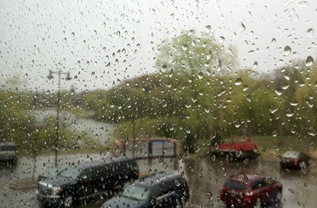
A fine, springy weekend is shaping up, enough sun for 70s, even a shot at 80 far southern Minnesota. A major tornado outbreak is likely today over the central Plains (as close as Iowa) - a few severe cells may brush southern Minnesota. Stay alert for watches and warnings.
I'm burying the lead, for good reason. After sampling lukewarm 70s we go over a temperature-cliff Monday; a 30 degree temperature drop is likely. Low 40s by Monday? Yep. A few flurries are possible in the metro, maybe 3-6" of flurries from Duluth into northern Wisconsin.
That's one of the great things about Minnesota. Don't like the (current) weather? Just wait an hour or two. It'll change.
Climate Stories...
From A Boy Who Loved NASA: How Could 49 Former NASA Astronauts And Scientists Soil Their Good Names Over Climate Politics? An important post from Shawn Lawrence Otto at
Neorennaisance: "
When I was a boy, I loved NASA. So imagine how pleased I was to be invited to speak at NASA Goddard Space Flight Center this week - where the kindly, soft-spoken and brilliant Willy Wonka of the place, astrophysicist John Mather, and his team are building the James Webb Space Telescope - perhaps humanity's most ambitious engineering project - and where scientists use satellites to study climate change in incredible detail. My talk, on Wednesday, was about the subject of my new book, called Fool Me Twice: fighting the assault on science in America, and how NASA scientists, particularly NASA climate scientists, could communicate complex science in the face of antiscience attacks, such as those by global warming deniers. At that very moment a living example was was happening all around me. I started getting texts, tweets and emails about 49 former NASA employees who were taking the agency to task for publishing information on climate change."
49 Cliff Clavin's Walk Into A Bar And Talk Climate Change. A post related to the indignant NASA astronauts from local St. Thomas professor John Abraham at
desmogblog.com: "
You could almost set your watch by it. It has become a regular absurdity that a bunch of non-scientists try to tell the world that they know something the experts don’t. Those of us who watched that iconic television show called Cheers remember Cliff, the mailman. He considered himself the expert on everything even though it was painfully obvious he knew very little about anything. Well we got our latest batch of Cliff Clavin wisdom this past week when 49 former staff members from NASA wrote a letter to NASA administrators decrying the work that the organization does on climate. It makes one wonder what the thousands of current NASA employees think of their former colleagues."
On The Intellectually Empty, Politically Motivated Attacks On NASA Climate Scientists By Former Astronauts. Wait a minute - astronauts are lecturing climate scientists (in their own organization) about climate science? Am I missing something here? It would be like a NASA climate scientist giving John Glenn tips on how to correct a burn to reach low-Earth orbit. Huh? More on this tempest in a NASA-teapot from
Climate Science Watch: "
With the 2013 NASA budget endangered by upcoming votes in Congress, attacks on Earth Science (where climate research and observing systems are funded) are to be expected. A denial machine letter signed by 49 former NASA administrators, astronauts, and engineers – i.e., folks who want to steer budget cuts away from human space flight – stoops to attacks on NASA climate scientists, essentially calling for them to be disowned and muzzled by their agency. The letter signers collectively have zero climate science expertise or relevant publications, in contrast with the NASA climate scientists, who are leaders in climate change research with a mountain of peer-reviewed publications. And endless impediments to honest discourse and meaningful action."
* more from NASA Watch
here.
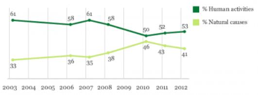
Public Understanding Of Climate Change: Getting Warmer. From Climate Progress and
grist.org: "
To go by the polls, the high point of public understanding of climate science was 2006 to 2008. That’s no surprise, since that period saw a peak in media reporting on climate science, starting in 2006 with An Inconvenient Truth, the documentary of Al Gore’s PowerPoint presentation on climate science, and continuing in 2007 with the four scientific assessment reports of the Intergovernmental Panel on Climate Change." Graphic above courtesy of Gallup and grist.org.
How Climate Change Makes Trees Sick. Here's an excerpt of a story from
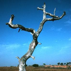
KQED-FM, public radio for northern California: "
A patch of tanoak, killed by Sudden Oak Death, in the Los Padres National Forest in Monterey County. Climate change is likely to wreak havoc on California’s forests. Extreme weather, wildfires and insect outbreaks will all take a toll. Add to those another looming threat: disease. Forest diseases like Sudden Oak Death, which has infected trees in 14 counties in the state, stand to benefit from the effects of climate change, to the detriment, obviously, of the trees. Trees are big and long-lived. Tree pathogens, mostly fungi and bacteria, are the opposite. They’re mobile, able to blow around on the wind. And they reproduce and evolve rapidly. That’s the crux of the problem, according to Susan Frankel, a plant pathologist with the Forest Service."
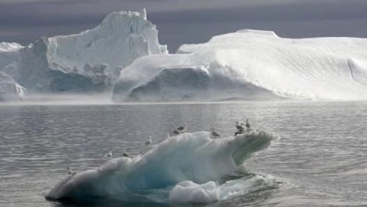
Rising Pacific Seas Linked To Climate Change. Here's an excerpt of a story at
Mother Nature Network: "
SYDNEY — Sea levels in the southwest Pacific started rising drastically in the 1880s, with a notable peak in the 1990s thought to be linked to human-induced climate change, according to a new study. The research, which examined sediment core samples taken from salt marshes in southern Australia's Tasmania island, used geochemistry to establish a chronology of sea level changes over the past 200 years. Patrick Moss, from the University of Queensland, said major environmental events that impacted the ocean, such as the introduction of unleaded petrol and nuclear tests, showed up in the samples and were used for dating."
Photo credit above: "
WATERY CULPRIT: Seagulls standing on an iceberg in a fjord, near Ilulissat in Greenland, in 2007. The Greenland ice sheet is likely the source of rising waters in the Pacific Ocean. (Photo: Michael Kappeler/AFP)."
Addressing Climate Change Through Diet. From VOA,
Voice of America: "
A new study says one of the best ways to curb greenhouse gas emissions is to eat less meat. In fact, the study says meat consumption in the developed should be cut by 50 percent per person by 2050."