Thanks to everyone who came out to and said hello while I was at the Startribune booth on Saturday. As expected, the rain came... I was
delagated to selling umbrellas and ponchos! I've never seen such a mad
dash for waterproof gear like that before! We literally sold hundreds of
items during the 1 hour soak. Ponchos sold out in about 30 minutues and
umbrellas started flying off the shelf. Seemed like everyone still
managed to enjoy themselves even with the rain.


It
was also the first time I've seen the Giant Slide getting a good scrub
from severeal workers... After the rain, several people worked
diligently to dry the slide.

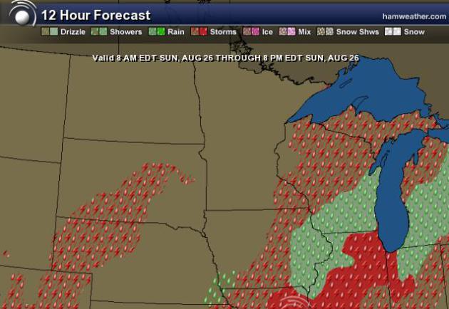
Sunday Weather
The
front that brought soggy weather conditions to the region on Saturday
will slowly push east on Sunday. It appears a little cloudy/soggy to
start, but there will be improving weather conditions through the day.
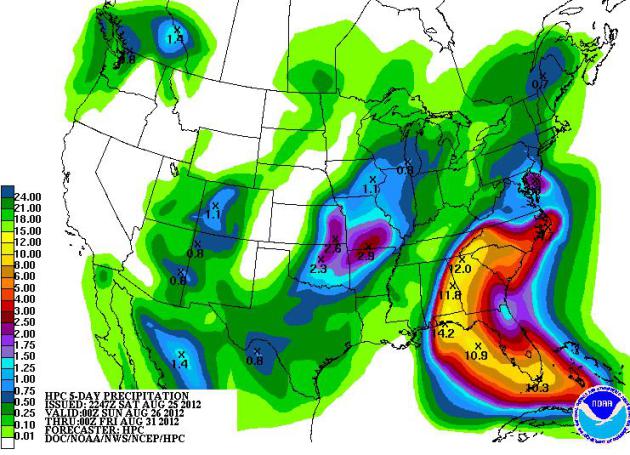
Heavy Flooding Rains Expected in the Southeast
NOAA's HPC 5
day rainfall forecast suggests nearly 12"+ in spots of the southeastern
U.S. as Isaac draws near. Let's just hope that impacts from wind damage
and storm surge remain minimal.
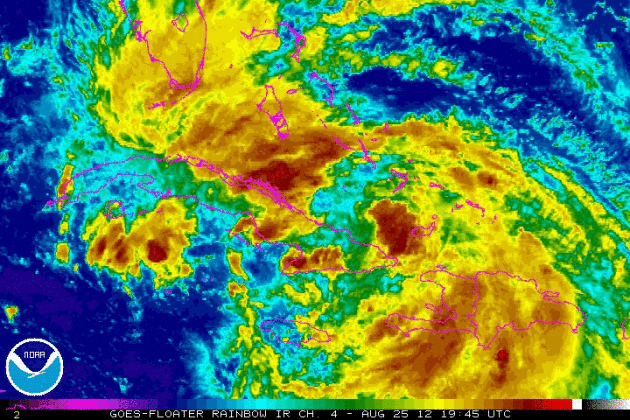
Eyes on Isaac
DISCUSSION AND 48-HOUR OUTLOOK
------------------------------
AT 1100 PM EDT...0300 UTC...THE CENTER OF TROPICAL STORM ISAAC WAS
LOCATED NEAR LATITUDE 22.1 NORTH...LONGITUDE 77.2 WEST. ISAAC IS
MOVING TOWARD THE NORTHWEST NEAR 17 MPH...28 KM/H...AND THIS
GENERAL MOTION IS EXPECTED TO CONTINUE DURING THE NEXT 48 HOURS.
ON THE FORECAST TRACK...THE CENTER OF ISAAC SHOULD MOVE JUST
NORTH OF THE CENTRAL COAST OF CUBA TONIGHT...AND MOVE NEAR
OR OVER THE FLORIDA KEYS SUNDAY OR SUNDAY NIGHT. ISAAC IS
FORECAST TO MOVE OVER THE SOUTHEASTERN GULF OF MEXICO BY EARLY
MONDAY.
MAXIMUM SUSTAINED WINDS ARE NEAR 60 MPH...95 KM/H...WITH HIGHER------------------------------
AT 1100 PM EDT...0300 UTC...THE CENTER OF TROPICAL STORM ISAAC WAS
LOCATED NEAR LATITUDE 22.1 NORTH...LONGITUDE 77.2 WEST. ISAAC IS
MOVING TOWARD THE NORTHWEST NEAR 17 MPH...28 KM/H...AND THIS
GENERAL MOTION IS EXPECTED TO CONTINUE DURING THE NEXT 48 HOURS.
ON THE FORECAST TRACK...THE CENTER OF ISAAC SHOULD MOVE JUST
NORTH OF THE CENTRAL COAST OF CUBA TONIGHT...AND MOVE NEAR
OR OVER THE FLORIDA KEYS SUNDAY OR SUNDAY NIGHT. ISAAC IS
FORECAST TO MOVE OVER THE SOUTHEASTERN GULF OF MEXICO BY EARLY
MONDAY.
GUSTS. STRENGTHENING IS FORECAST DURING THE NEXT 48 HOURS...AND
ISAAC IS EXPECTED TO BE AT OR NEAR HURRICANE STRENGTH WHEN IT
REACHES THE FLORIDA KEYS.
TROPICAL STORM FORCE WINDS EXTEND OUTWARD UP TO 205 MILES...335 KM
FROM THE CENTER.
ESTIMATED MINIMUM CENTRAL PRESSURE IS 997 MB...29.44 INCHES.
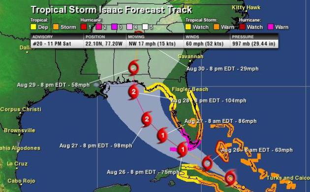
Forecast Track
As expected, Isaac will quickly intensify as he moves into the warmer waters of the Gulf of Mexico. There are still factors that could affect Isaac, but the overall consensus is to make landfall near Florida/Alabama by late Tuesday night/early Wednesday morning.
See more from the National Hurricane Center HERE:
Thanks for checking in, enjoy the rest of your weekend.
Don't forget to follow me on Twitter @TNelsonWNTV