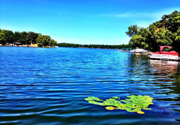
Sunday, August 19th, 2012
Glad I made the trip out to visit my
Grandparents in Wisconsin on Friday... what a beautiful day! The image
below is from the dock on Bear Trap/Wapogasset Lake (or Lake Wapo to the
locals). Our first REAL cool front of the season allowed cool Canadian
air to settle south of the border for an extended period, something that
we haven't seen much of over the past few months.
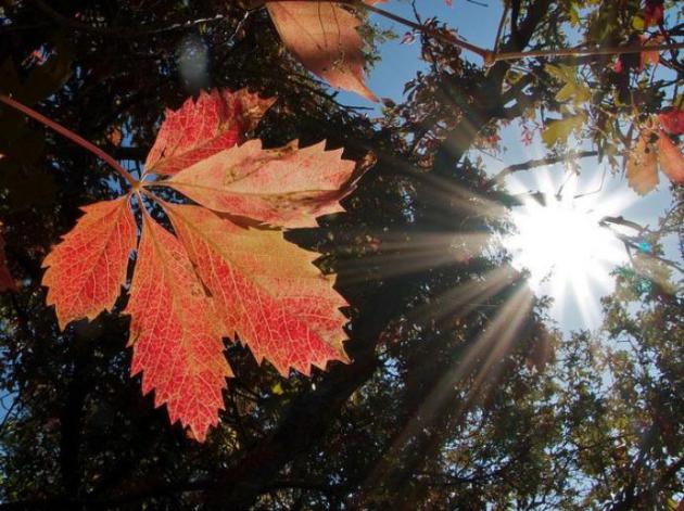
Signs of September
Thanks to my good friend, Dan Hanger, for
the picture below. He snapped this from Duluth, MN where signs of Fall
are already starting to show up. Keep in mid that the mercury dipped to
33F in Silver Bay on Friday morning! It appears that some of the
folliage across the far north are already reacting to the significant
loss of daylight since the Summer Solstice (in mid/late June) and the
recently chilly overnight lows.
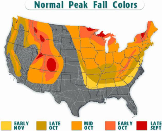
Fall Color Not Far Away
The image below from Brian Wilder's Blog via Trulia.com,
shows the average fall color peak across the nation. Note how parts of
northern Minnesota start to peak in late September... that's only a few
weeks away! The rest of the state starts to peak in October.
Holy Allergies Batman!
Not sure about you, but by late August my
seasonal allergies start to REALLY kick in and this is the first weekend
where it is starting to get ridiculous. The latest info from pollen.com suggests the worst cities for pollen across the entire U.S. are:
Minneapolis, MN
Fargo, ND
Grand Forks, ND
Jamestown, ND
Bismarck, ND
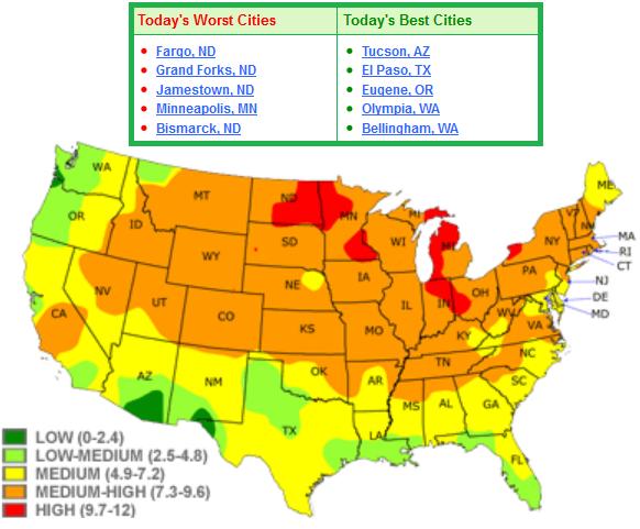
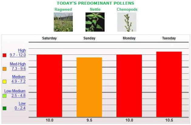
Minneapolis Pollen Forecast
If you're wondering why you're sneezing so
much or why your eyes are so itchy, it's proabably because pollen counts
in the Twin cities are through the roof! The image below is the pollen
count over the weekend and forecast into early next week, which remains
HIGH!
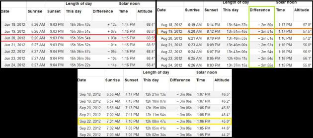
Losing Daylight Rapidly
The tables below show the sunrise/sunset
and time of day from mid/late June (Summer Soltice) to mid/late August
(now) to mid/late September (Autumnal Equinox). Note first how we're
losing nearly 3minutes of daylight each day (outlined in green).
Sunrise/Sunset times today are 6:20am and 8:12pm, which gives us about
13hours and 52minutues of daylight. This is down almost 1hour and
45minutes from the longest day of the year about 2months ago. We are 34
days from the Autumnal Equinox, which rings in this year on September
22nd. We will lose another ~1hour and 45minutues of daylight by then!
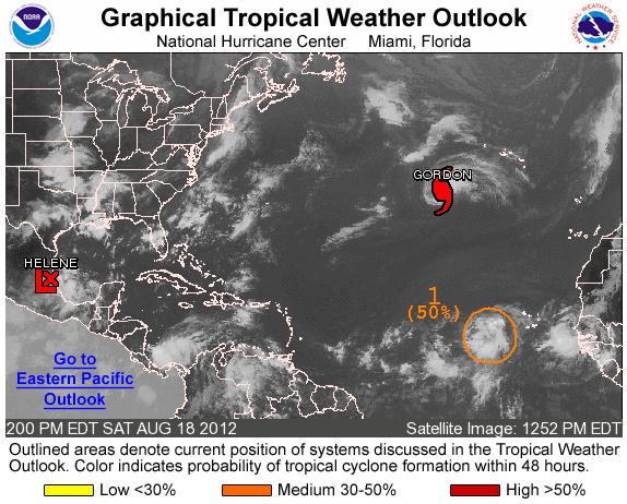
Hurricane Season Continues
Hurricane Season runs from June 1st to
November 20th, but typically peaks in September when water temps are at
their warmest. The Atlantic basin is currently quite active with several
areas of interest. The National Hurricane Center continues watching
Gordon and Helene, but is also watching a wave in the central Atlantic,
which could become Isaac.
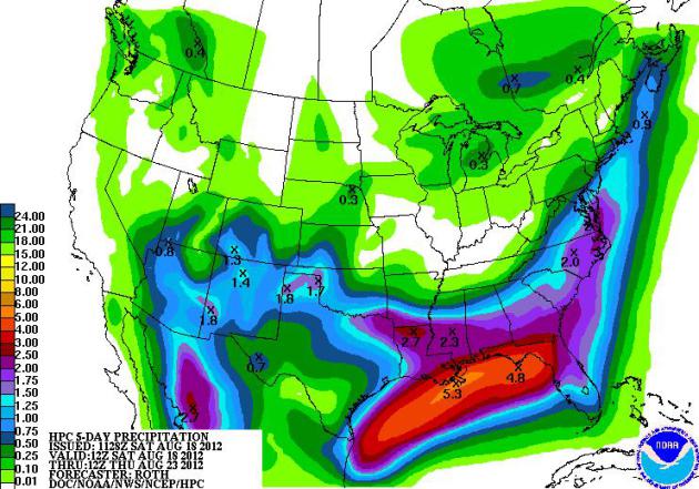
Helene to Bring Heavy Rain
NOAA's HPC 5 day rainfall forecast keeps
most of the rain from Helene across the Gulf Coast from near New Orleans
into northern Florida. Some areas could get soaked with nearly
5" through the middle part of the week. Also note the heavy rain pockets
in the Southwest due to monsoon moisture, but also not the lack of much
needed moisture across the middle part of the country.
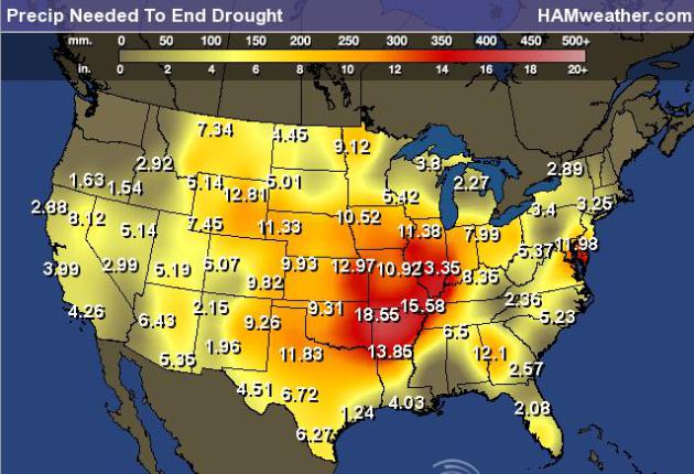
Precip Needed to End Drought
Many farmers across the nation are dealing
with loss this year due to the drought. Even if we picked up
significant moisture in the near future, it would be too late to
recover from the significance of the lack of moisture this growing
season. The image below suggests how much rain is needed to get back to
normal. Remarkably, some spots need nearly one and a half feet of rain
to get back to normal!
Significant Low River Flows
The lack of moisture through the central
part of the country has also caused some issues along the
Mississippi River. Not only have barges been running into low waters
levels, but large (unsafe) beaches have been showing up along the
shore. WNTV Meteorlogist Gretchen Mishek has more information.
Tempting New Beaches
New beaches appearing due to abnormally
dry conditions along the Mississippi are tempting swimmers and boaters
but experts say it is a dangerous situation.

AP Photo/Robert Ray
Here’s more from the Washington Post:
“A lack of rain in the United States’ midsection in recent months has
reduced water levels in some of the nation’s biggest rivers, exposing
sandbars that experts warn could be deadly quicksand. Rivers such as the
Mississippi and Missouri are typically low in August, but this year’s
drought has them at their lowest point in decades. The sandbars that
are revealed look like beaches, inviting boaters, fishermen and hikers
to venture out. Experts agree that can be a very bad idea. Steve Barry,
emergency management chief for the Corps of Engineers office in
Memphis, Tenn., said the exposed sand looks dry on top but it is really
saturated mud. Combined with the undercurrent of water in the
fast-moving rivers, that creates a true danger.”

Diagram from: http://www.unmuseum.org/quicksand.htm.
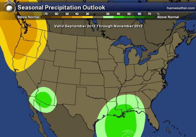
Seasonal Precipitation Outlook
Unfortunately for folks dealing with
drought this year, the precipitation outlook for meteorological fall is
not suggesting above normal chance chances of widespread precipitation.
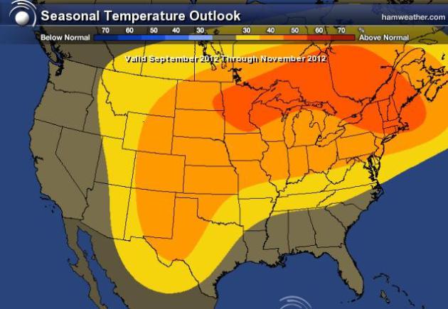
Seasonal Temperature Oulook
It sure is nice to have a little reprieve
from the excessive heat as of late, but the Climate Prediction Center
suggests that meteorological fall will consist of above normal
temperatures through the middle part of the country. There is an above
normal chance that this will occur.
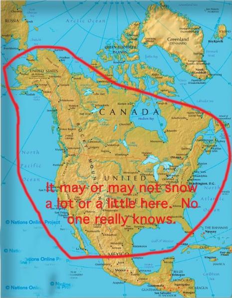
LOL ALERT - Snowfall Forecast This Winter
LOL - For those of you interested in what
the winter will bring, Jon Collet says that after careful study and
calculation, he came up with this extended winter forecast for
snowfall... Thanks for a good chuckle Jon.
Thanks for checking in, have a great rest of your weekend and week ahead!
Don't forget to follow me on Twitter @TNelsonWNTV