78.14% of the USA is described as "abnormally dry".
24.14% of America is in extreme or exceptional drought, nearly a quarter of the Lower 48 States.
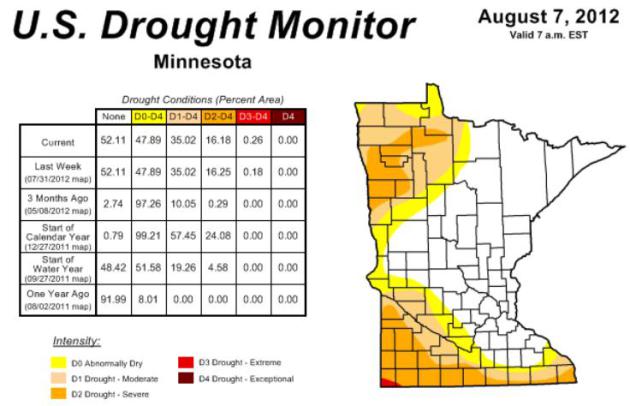
16.18% of Minnesota in severe drought, down slightly from 16.25% last week.
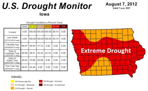
69.14% of Iowa in extreme drought, up from 30.74% last week.
Photo credit above: "
Buchanan County, Mo., employees Ron
Martin prepares to go back out onto Lake Contrary Thursday afternoon
Aug. 9, 2012, in his jon boat to pick up more dead fish while Shane
Hartman tosses what he collected into a front end loader. Low water
levels and extreme heat caused a sizable fish kill in the Oxbow lake
that the Missouri Department of Conservation estimates to be about
20,000 mostly invasive Asian Carp." (AP Photo/The St. Joseph News-Press, Eric Keith)
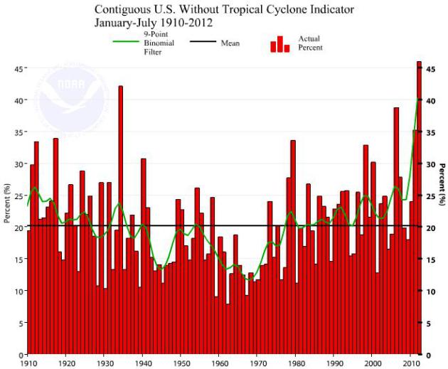
46% record high CEI Index (Climate Extreme Index)
for 2012, to date, surpassing the previous record of 42% in 1934.
Details from NOAA NCDC below. Photo: WeatherNation TV meteorologist
Bryan Karrick.
El Nino conditions "likely to develop during August or September 2012", according to NOAA. Details below.
"
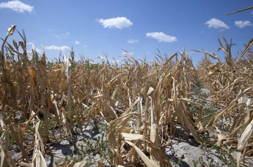
Nearly half of the nation’s corn crop is in poor or very poor
condition, as well as a third of soybeans. The damage would be much
worse without the crop science advancements of the last 40 years, said
Andrew Wood, a professor of plant physiology and molecular biology at
Southern Illinois University." - from a Washington Post article, details below. Photo credit: Nati Harnik, AP.
 Less Arctic Ice Than 2007?
Unusually warm weather is creeping into the Arctic, where ice loss is
on pace with the previous record, 2007. Not only the aerial extent of
ice but the volume of ice is dropping rapidly; details below.
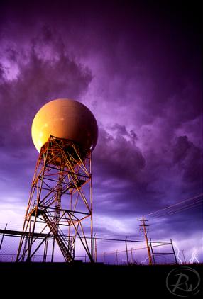
Twin Cities NWS Doppler Is Down For Maintenance. Actually, it's more than that - KMPX is being upgraded to "
dual polarization"
capabilities, a software and hardware upgrade that will help local
meteorologists predict everything from rainfall amounts, to winter
precipitation, even detect tornado signatures ("debris balls") with
greater accuracy. I'm holding my breath that there won't be any severe
weather outbreaks (doubtful) in the next week; until then we'll rely on
Doppler from Duluth, Sioux Falls and La Crosse. Photo above: Reid
Wolcott.
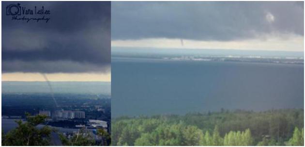
Thursday Waterspouts In Duluth. Check out the
remarkable photos of the waterspout that formed over Lake Superior, just
off the shoreline of Duluth. Photo upper left courtesy of Vana Leslee
Photography (via
WDIO). Photo upper left from Alissa Glickstein. Nicely done.
Minnesota Drought: Holding Steady. There was little
change in the drought status, statewide, in the last week; 47% of
Minnesota "abnormally dry", over a third of the state in a moderate
drought, 16% in severe drought, and a tiny sliver of far southwestern MN
in an extreme drought (near Worthington). Soil moisture from Rochester
and Mankato, north to the Twin Cities, St. Cloud and Duluth are in good
shape. More details from NOAA's
U.S. Drought Monitor.
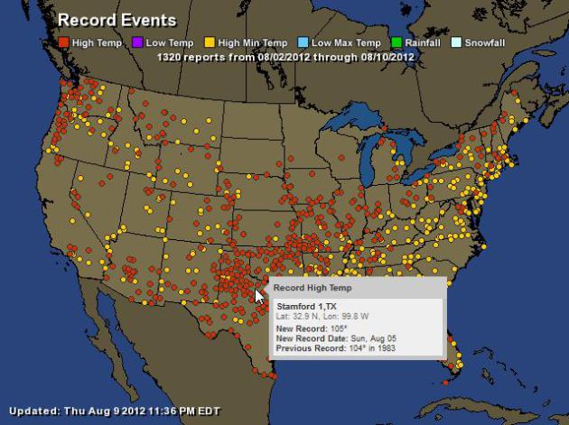
A Sprawling Heat. Although the Upper Midwest has
seen significant relief, much of America continues to sizzle: 1,320 warm
weather records since August 2, according to NOAA. Map courtesy of
Ham Weather.
A Sprawling Drought. An estimated 62.46% of the USA
is in moderate drought (or worse). The worst conditions can be found
from southern Indiana westward through Missouri and Arkansas into Kansas
and Oklahoma, pockets of exceptional drought as far south as Georgia.
More details from the
U.S. Drought Monitor.
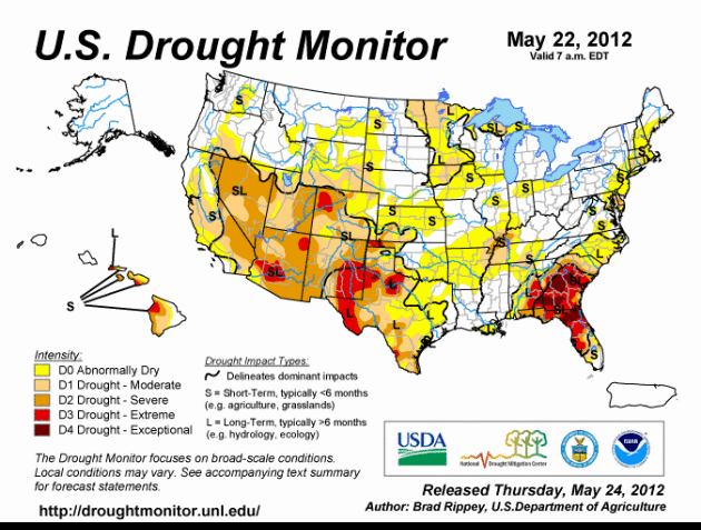
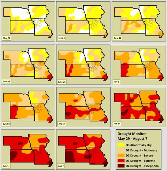
Drought Animation. You can see the progression of
the Great Drought of '12 since May 22 in this animation. The darker the
red: the more severe the drought - thought to be the worst since 1956,
possibly 1936.
Iowa Farmers Are In Trouble. At first I thought it
was a typo - I had to go back and check it again. The percentage of Iowa
in extreme drought jumped from 30.74% last week to 69.14% this week, a
nearly 40% jump. I've never seen that before. Details
here.
Evolution Of Drought. The steady spread of drought conditions since May 29 has been striking; more details from
NOAA: "
The
latest drought monitor is now available in the region. Once again,
extreme drought continues over much of Kansas and Missouri. However,
portions of the area have now been upgraded to the highest level of
drought, “exceptional”. The drought monitor does not include impacts of
rainfall from last night, but given the scattered nature of rain, the
improvements would be minimal. Since the beginning of the drought
monitor in 1999, this is the first “exceptional” drought status in
western Missouri."
Severe Losses For Reinsurers From U.S. Drought: Munich Re.
CNBC.com has the details; here's an excerpt: "
The
recent dry weather affecting crops across the midwest of America will
hit the reinsurance industry with perhaps the biggest loss ever,
according to Nikolaus von Bomhard, Chairman at Munich Re. “We do think
it will be severe and probably one of the severest losses for this
market ever,” he told CNBC Wednesday. “It’s too early to tell what the
exact claim will be because we have to wait until the harvest is done.”
The prolonged hot spell is said to be the worst in five decades and has damaged corn production across 26 U.S. states."
Photo credit above: "
A dry field of corn is seen near
Ashland, Neb., Thursday, Aug. 9, 2012. The latest U.S. drought map
shows that excessively dry conditions continue to worsen in the Midwest
states that are key producers of corn and soybeans. This is the worst
U.S. drought in decades. The weekly U.S. Drought Monitor map released
Thursday, Aug. 9. 2012 shows that the area gripped by extreme or
exceptional drought rose nearly 2 percent to 24.14 percent." (AP Photo/Nati Harnik)
2012: Most Climate Extremes On Record. Here's an explanation from NOAA: "
The
U.S. Climate Extremes Index (USCEI), an index that tracks the highest
and lowest 10 percent of extremes in temperature, precipitation, drought
and tropical cyclones across the contiguous U.S., was a record large 46
percent during the January - July period, over twice the average value,
and surpassing the previous record large CEI of 42 percent, which
occurred in 1934. Extremes in warm daytime temperatures (83 percent) and
warm nighttime temperatures (74 percent) both covered record large
areas of the nation, contributing to the record high year-to-date USCEI
value." Graph courtesy of
NOAA NCDC.
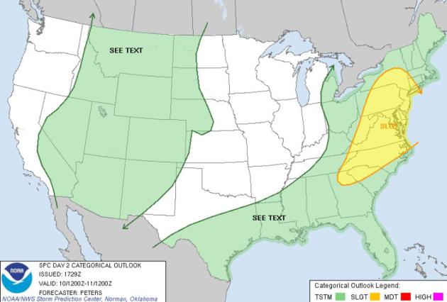
Friday Severe Threat. A stalled frontal boundary
becomes a focal point for severe storms later today from New York and
Albany to D.C. and Raleigh. Flying east? You may encounter delays. Map
courtesy of NOAA SPC.
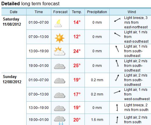
Weekend Outlook. The European model continues to
hold up Saturday as the better day of the weekend for outdoor
plans: highs in the upper 70s to near 80 with a light southeast breeze.
Timing Sunday showers is tricky; no all-day rains, but a couple hours
are possible with highs in the low 70s.
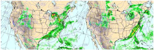
Slow-Motion Weather Map. The WRF model shows a
slow-moving cool frontal boundary stalling over the eastern seaboard by
Saturday, compounding rainfall amounts from the Mid Atlantic region to
the Florida Panhandle. High pressure treats the Northern Plains and
Upper Midwest to comfortable sun. The Great Lakes will see frequent
showers and T-storms, mainly dry weather west of the Rockies. Upper
left: today at 4 pm. Upper right: Saturday at 4 pm.
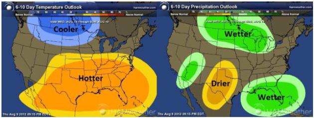
First Hints Of Autumn. Remarkable news: we may enjoy
a spell of cooler, wetter than normal weather as we sail into
mid-August. NOAA's Climate Prediction Center 6-10 Day Outlook shows a
cool, wet bias for the Northern Plains and Upper Midwest - more
relentless heat for the southern half of America. Map:
Ham Weather.
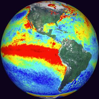
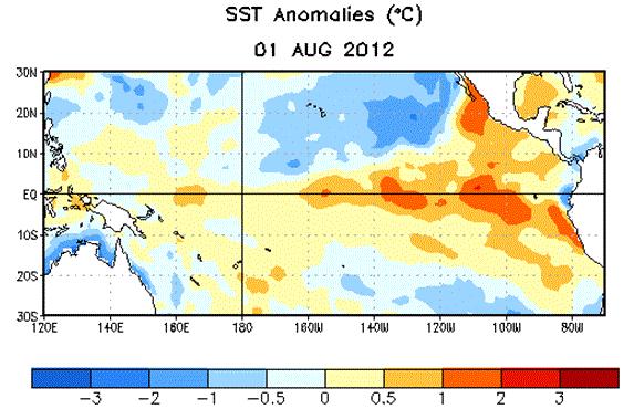
NOAA: "El Nino Conditions Likely To Develop During August Or September 2012". More details from
NOAA NCEP: "
ENSO-neutral
conditions continued during July 2012, despite above-average sea
surface temperatures (SST) across the eastern Pacific Ocean. Reflecting
this warmth, most of the weekly Nino index values remained near or
greater than +.5 C. The oceanic heat content anomalies (average
temperatures in the upper 300 meters of the ocean) also remained
elevated during the month, consistent with a large region of
above-average temperatures at depth across the equatorial Pacific.
Althugh sub-surface and surface temperatures were above average, many
aspects of the tropical atmosphere were inconsistent with El Nino
conditions."
Graphic credit above: "
Average sea surface temperature
(SST) anomalies (C) for the week centered on 1 August, 2012. Anomalies
are computed with respect to the 1981-2010 base period weekly means."
NOAA Raises Hurricane Season Prediction Despite Expected El Nino.
The forecast calls for El Nino by autumn (see above). El Nino patterns
usually imply stronger winds over the tropics - conditions not favorable
for hurricane development (those winds tend to shred developing
tropical storms and prevent them from reaching their peak potential). In
spite of this,
NOAA NHC is predicting a higher than average number of tropical systems: "
This
year’s Atlantic hurricane season got off to a busy start, with 6
named storms to date, and may have a busy second half, according to
the updated hurricane season outlook issued today by NOAA’s Climate
Prediction Center, a division of the National Weather Service. The
updated outlook still indicates a 50 percent chance of a near-normal
season, but increases the chance of an above-normal season to 35
percent and decreases the chance of a below-normal season to only 15
percent from the initial outlook issued in May.
Across the entire Atlantic Basin for the season – June 1 to
November 30 – NOAA’s updated seasonal outlook projects a total (which
includes the activity-to-date of tropical storms Alberto, Beryl,
Debbie, Florence and hurricanes Chris and Ernesto) of:
- 12 to 17 named storms (top winds of 39 mph or higher), including:
- 5 to 8 hurricanes (top winds of 74 mph or higher), of which:
- 2 to 3 could be major hurricanes (Category 3, 4 or 5; winds of at least 111 mph)
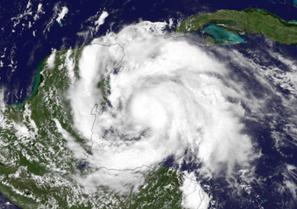
Photo credit above: "
Satellite image of Hurricane Ernesto taken on Aug. 7, 2012 in the Gulf of Mexico." (Credit: NOAA)
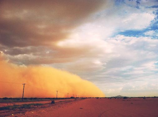
Haboob! I still have trouble talking about haboobs
without chuckling. Sorry. I know, infantile. One of many personal
defects. Thanks to Mike Olbinski, who shot this advancing wall of dust
and sand outside Phoenix. Amazing.
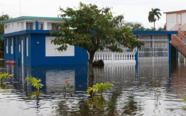
Get Flood Insurance Before You Need It. Are you in a flood zone? When was the last time you checked? Here's an excerpt of an important article from
Reuters: "
The
best time to get protection against a flood is before it happens. That
means if you keep anything in a basement or live on the ground floor,
it's important to have flood insurance. Floods are the most common natural disaster and they can cause significant damage.
Buying flood insurance is always a good idea but in some cases it's
also mandatory. It's important to understand how and when to buy flood
insurance so that you're prepared before disaster strikes.
The Federal Emergency Management Agency administers the National Flood
Insurance Program which is generally a good place to start.
Under federal law, homes with a federally regulated mortgage must have
flood insurance if located within a Special Flood Hazard Area. Even if
your home is not within a SFHA, banks may require that you have flood
insurance before approving a mortgage." Photo credit: NOAA.
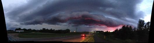
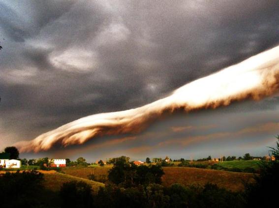
Photo Of The Day. Art Fightmaster captured a photo of a sunlit shelf cloud in Gardnersville, Kentucky Thursday. Photo courtesy of
WeatherNation TV.
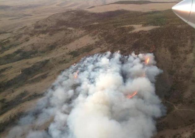
Flames From Above. Photo courtesy of Wyoming's
Bureau of Land Management: "
Yesterday,
firefighters were able to mop-up the perimeter of the Sheep Park
Wildfire south of Jeffrey City. The fire burned 528 acres and is
approximately 90% contained."
Weather Services International Acquires Weather Central.
This may be inside baseball, but WSI (owned by The Weather Channel) and
Weather Central create the weather graphics systems that 90% of
America's TV stations and networks use for weather visualization. Full
disclosure: a previous company of mine, "EarthWatch Communications", was
acquired by a local company, Kavouras, back in 1997, which went on to
license 3-D weather technology to Weather Central, which is about to be
owned by WSI, which is owned by The Weather Channel. Confused? Me too.
Not sure how this will impact the TV weather graphics landscape, but I'm
keeping an open mind. Details from Madison-based
Weather Central:
"Weather
Services International (WSI) today announced an agreement to acquire
Weather Central, a Madison, WI based global provider of interactive
weather technology, graphics and data services for professional, media,
and consumers delivered to television, web and mobile screens. Terms
of the agreement were not disclosed. “The acquisition of Weather
Central enables us to immediately expand the range of products we offer
to each company’s business clients in television, wind energy,
insurance and retail, as well as increase the speed at which we can
develop new innovations,” said Mark Gildersleeve, president of WSI.
“Our goal is to make the best products available to our collective
customer base. Every broadcast customer, for example, will gain access
to new tropical data, radar data, forecast models, and severe weather
tracking tools within the first thirty days at no charge. In addition,
we are offering a wider suite of products in the interactivity, social,
news, traffic, web, mobile and video categories.”
How To Make Your Lost Phone Findable. The New York
Time's David Pogue had quite an adventure last week; he lost his phone,
and using Twitter (and local police) was able to track it down. But it
got him thinking; what technology or apps can I utilize to find my
phone, if and when it gets lost again? Here's an excerpt from his column
at
The New York Times: "
Last
week, I lost my iPhone on a train. I used Apple’s Find My iPhone
feature to track it to a house in suburban Maryland, and the local
police were able to return it to me. Because I’d tweeted about these
developments, the quest for the phone became, much to my surprise, an
Internet-wide, minute-by-minute real-life thriller. (You can read the
whole story here.)
Several readers wrote to ask how to set up their own phones to be
findable. As you’d guess, given last week’s experience, I have some
strong feelings about the importance of setting up Find My iPhone or the
equivalent on Android phones."
Ford Pushes Speed And Economy Rating Of 2013 C-MAX Hybrids. This new car from Ford caught my eye; a potential Prius-killer?
Gizmag.com has details: "
Ford definitely appears to have Toyota in its sights with its 2013 C-MAX line. Having already revealed the C-MAX Hybrid will be cheaper than Toyota’s Prius v,
the U.S. automaker is now boasting that its hybrid utility vehicle
beats the Prius v in the fuel economy stakes by up to 7 mpg (2.9 km/l).
It is also the first vehicle to offer the same fuel economy rating in
both city and highway driving."
The Edge of Drought
You may not believe it but we've been relatively
lucky this summer. No deadly tornadoes or flash floods; ample soil
moisture for much of Minnesota. Yes, drought is creeping into southern
& western counties; a third of the state now in moderate drought. It
could be much worse. The percentage of Iowa in extreme drought has
spiked from 30 to nearly 70 percent in just the last week. I've never
seen that before.
NOAA NCDC says 2012, to date, is the most
extreme year ever recorded across the USA - even more temperature &
rainfall extremes than 1934, the previous record, at the height of the
Dust Bowl. Every day I drive into the Weather Center studios, holding my
breath. What next?
A weak bubble of high pressure chases away the
clouds today. Expect comfortable sun; 70s with a dew point near 50.
Saturday looks like the sunnier, nicer day. Another clipper-like system
sparks showers Saturday night into a portion of Sunday. Get out
tomorrow, if possible.
Cool 70s linger the next 3 days. Yes, it's good to be "average again".
Enjoy, because highs may approach 90 by next Wednesday.
Drumroll: NOAA says El Nino should return by autumn. Another milder Minnesota winter? Place your bets.
* photo credit above: Seth Perlman, AP.
Climate Stories...
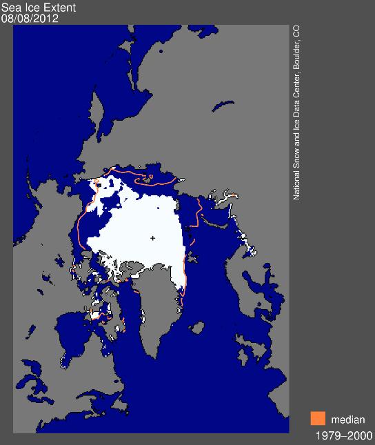
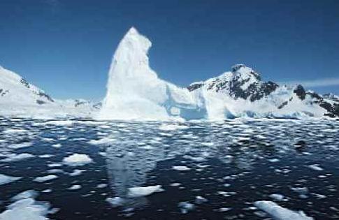
Sea Ice Extent. I took one look at this graphic and
my jaw dropped. We are on target for the lowest summer Arctic ice levels
in recorded history. More details on Sea Ice Extent from the
National Snow And Ice Data Center: "
These
images, derived from passive microwave satellite data, depict the most
recent daily sea ice conditions. Extent images show the total area of
ocean covered with at least 15 percent ice. Concentration images show
varying degrees of ice coverage, from 15 to 100 percent. Monthly images
are more indicative of trends than daily images."
On Track For A Record Sea Ice Minimum. An explanation from NSIDC:
"These
satellite-derived images depict current sea ice conditions and trends.
Long-term changes in Arctic sea ice are an index of climate change.
Southern Hemisphere sea ice images are also available. For more
information about current conditions and their significance, see Arctic Sea Ice News and Analysis."
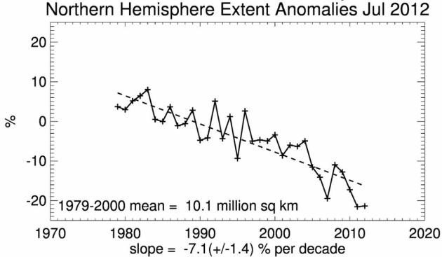
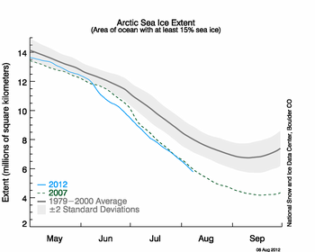 Arctic Sea Ice Extent
. We're on track for a new record ice minimum within 30 days.
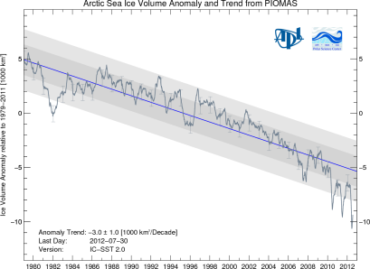 Arctic Sea Ice Volume
. Volumetric trends in the Arctic are even more troubling, literally off the scale. Graph: PIOMAS.
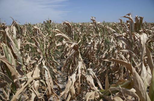
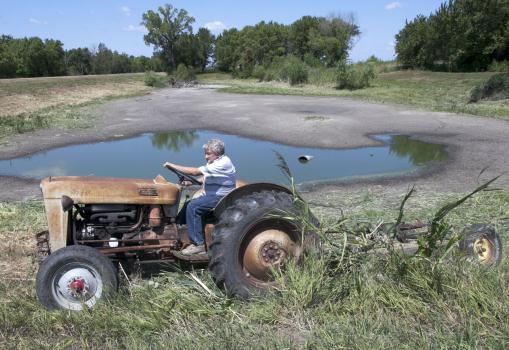
To Confront Climate Change, U.S. Agriculture Seeks Hardier Breeds That Can Survive Long Droughts.
Universities and private ventures are already working on new strains of
corn, wheat and beans that can better withstand extended dry spells
(and sudden floods). The financial upside for the firms that figure this
out will be astronomical. Here's a timely story from AP and
The Washington Post: "
Cattle
are being bred with genes from their African cousins who are
accustomed to hot weather. New corn varieties are emerging with larger
roots for gathering water in a drought. Someday, the plants may even be
able to “resurrect” themselves after a long dry spell, recovering
quickly when rain returns. Across American agriculture, farmers and crop
scientists have concluded that it’s too late to fight climate change.
They need to adapt to it with a new generation of hardier animals and
plants specially engineered to survive, and even thrive, in intense
heat, with little rain."
Photo credit above: Nati Harnik, AP. "
Jerry Johnson of
Ashland uses his antique 57 Ford tractor to mow vegetation around his
drying pond in Ashland, Neb., Thursday, Aug. 9, 2012, which he hopes
will keep the critters away."
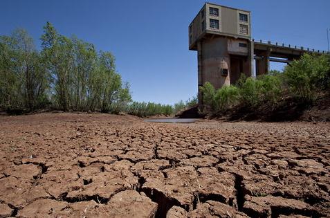
How To Parse Climate Change And Extreme Weather. Here's an excerpt of a John Broder Op-Ed on connecting the dots in
The New York Times: "
James
E. Hansen, the irrepressible NASA scientist who was among the first to
sound the alarm about human-caused global warming, has roiled the
scientific community again with a new scientific paper
explicitly linking high concentrations of carbon dioxide and other
heat-trapping gases to recent severe heat waves and drought. My
colleague Justin Gillis has a detailed article
in Tuesday’s Times on the study and the initial reaction to it. In the
paper, published in the prestigious Proceedings of the National
Academy of Sciences, Dr. Hansen and two co-authors say that human
activities – chiefly the burning of fossil fuels – have “loaded the
dice,” making extreme weather events more frequent. They go further and
say that the drought in the United States and the deadly heat wave in
Russia, among other recent weather extremes, were direct consequences of
this phenomenon."
Photo credit above:
Robert W. Hart for The Texas Tribune. "A pump house at Lake J.B. Thomas in west-central Texas sat high and dry last year."
Six Tips For Newly Climate-Concerned Americans. Some good advice from Mike Sandler at The Huffington Post; here's an excerpt: "...
Direct
experience with heat waves and drought may be moving some Cautious and
Disengaged people into the Concerned category. These individuals may
benefit from a few tips for dealing with their new worries about
climate change:
- Build Community -- it helps. If your
existing community watches Fox News, or listens to Rush Limbaugh, then
your new concern about climate change will cause some cognitive
dissonance. That's OK, you'll be facing cognitive dissonance quite a
bit at first, like every time you switch on a light or drive your car.
Joining a community that recognizes the paradoxes that climate change
brings to modern Americans can help during those first troubling weeks,
months, and years.
- Listen to upbeat messages. Upbeat,
positive messages about humanity, or about our ability to change, adapt,
survive, and help each other through tough times can be helpful in
countering anxiety after reading several depressing articles about the
coming climate-pocalypse. A good example is a lyric from Bob Marley's
"Three Little Birds": "Every little thing, gonna be alright."
Climate Change Adaptations: How To Prepare For Global Warming.
Underground cities and floating farms? Hey, who knows - we're all going
to have to think outside the (warming) box to come up with viable
solutions, to grow global economies while mitigating the worst symptoms
of a warmer world. Here's an excerpt from an intriguing story at Huffington Post: " Wild
geoengineering schemes may aim to reverse global warming by reflecting
sunlight into space or storing excess carbon dioxide, but they won't
spare humanity from living through climate change in the next several
decades. That means humans must adapt to life in a world where droughts
hit harder, floodwaters rise higher and entire island nations may sink
beneath the waves. 'Some adaptation ideas resemble science fiction made
real — growing crops inside city buildings, floating villages and
genetically engineered crops. Other solutions, such as floating
agriculture and traditional species cross-breeding, draw upon the long
history of human adaptation rather than futuristic technologies.
Waterworld homes: When the waters rise, tomorrow's buildings may rise with them as floating structures. Koen Olthuis, head of Waterstudio.NL,
has begun working on projects ranging from floating apartments in the
Netherlands to a floating mosque in the United Arab Emirates."