23 F. average high for January 8.
12 F. high temperature a year ago.
-32 F. record low for today's date (1977).
49 F. record high in the Twin Cities for today and Tuesday. We may come close, especially tomorrow.
January 12: the coldest day of the year, based on the latest 30 year weather averages for KMSP.
2: fewest number of subzero nights in a single winter here in the Twin Cities (2001-2002).
+12.4 F. January temperatures are running more than 12 degrees above average at KMSP.
+15.6 F. January temperatures at International Falls are more than 15 degrees above average.
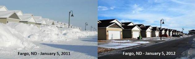
What A Difference A Year Makes. Trite? Cliche? You 'betcha. I'm not above that. But (as the saying goes) "a picture tells a thousand words." Photo comparison above courtesy of InForum.
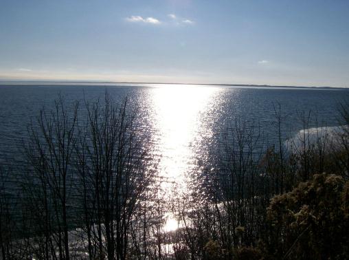
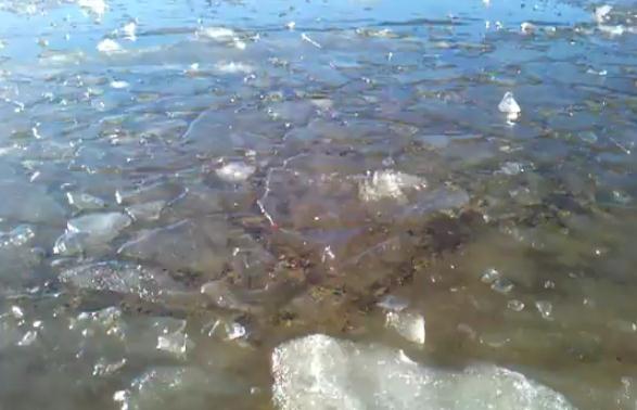
Ice-Free On Lake Mille Lacs? In early January? What planet are we living on again? Here are more details about this photo: "A large swath of Lake Mille Lacs was ice-free on Saturday -- a testament to the unseasonably warm weather this winter. This view is looking southwest from Myr Mar Point on the north side of the lake. Locals say they've never seen open water this time of year. Photo by Steve Fellegy."
"A lot of people like snow. I find it to be an unnecessary freezing of water." - Carl Reiner
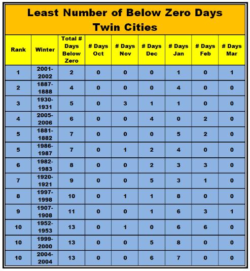
Fewest Subzero Nights. Since 1983 we've had 7 winters that made the "Top 10 Fewest Subzero Nights" list here in the Twin Cities; the fewest was 10 years ago, when the mercury dipped below zero only twice. I have a (strong) hunch this winter will also wind up in the Top 10 List. More details from the National Weather Service here.
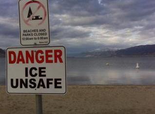
January Melt-Down. Check out the YouTube clip (taken on an Android phone) from WeatherNation meteorologist Aaron Shaffer on Lake Calhoun yesterday. Actually - he was on the shoreline, which - judging by the quality of the ice - was a very good idea. Be very careful out there; ice will become even more unstable between now and midweek. Some improvement is likely by next weekend, but it's going to take a few days of temperatures consistently below 32 to firm up ice on area lakes.
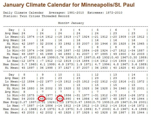
Close To Record Territory? The record high for today and Tuesday is 49. Today's record dates back to 2002 (the winter with only 2 subzero lows); tomorrow's record of 49 goes back to 1990. We may come close, especially tomorrow. 30 year (1981-2010) averages for MSP courtesy of the Minnesota Climatology Working Group.
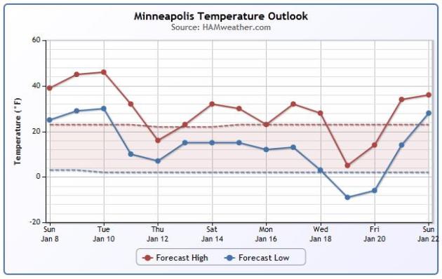
Consistently Warmer Than Average. The latest GFS temperature plot through January 22 shows a distinct cooling trend later this week, another (fleeting) cold smack around January 18-20, when the mercury may dip below zero for the first time all winter. Graphic above courtesy of Ham Weather. BTW, the record for the latest subzero temperature on record at MSP is January 18. We may come very close to breaking that record this year.
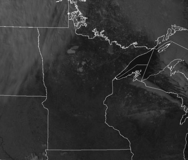
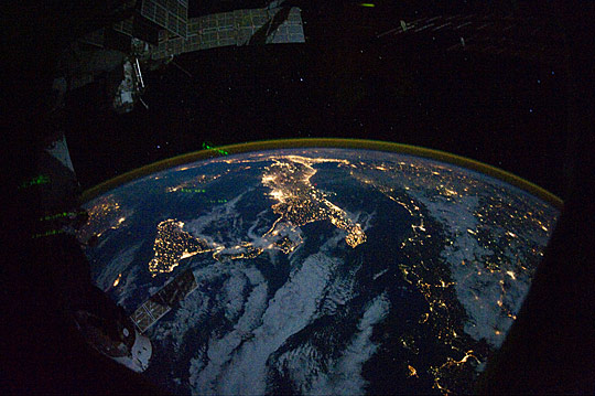
Where's The Snow? Looking at Sunday's 2:30 pm visible satellite image the frozen lakes up north are easy to pick out (especially Leech and Red Lake). But I'm struck by the utter lack of snow, even up north, where a couple feet of snow should be on the ground right now.
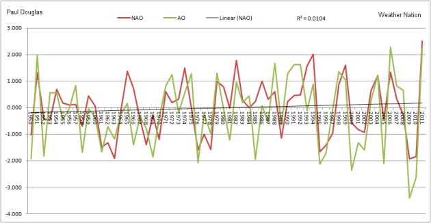
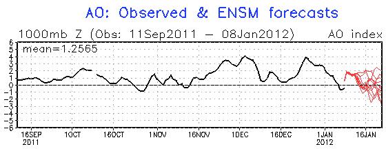
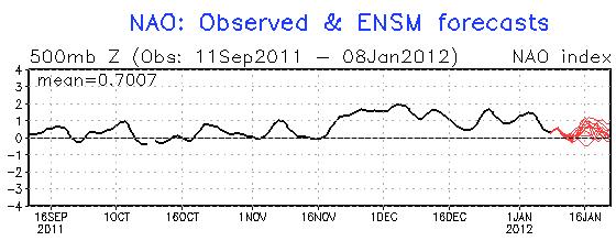
Still Waiting For A (Pronounced) Phase Shift. The AO (Arctic Oscillation) and NAO (North Atlantic Oscillation) have been strongly positive for the last few months - meaning persistent west winds howling across North America; bitter air bottled up over northern Canada. What's it going to take for bitter air to reach Minnesota? The AO and NAO will need to drop consistently below zero. Although the AO is forecast to drop to near zero after January 16 the NAO remains positive. That will probably mean a few close enounters with numbing air, but I still don't see any widespread or persistent outbreaks of subzero air, at least through the 25th of January. More from CPC here.
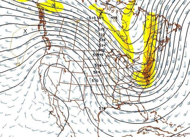
January 25: Modified Pacific Flow Lingers. We'll see glancing blows of numbing air over the next couple of weeks, but winds aloft are forecast to have more of a Pacific than a Canadian component for the next 2 weeks or so. The 12z 384 hour forecast valid 12z January 25 shows (what else): winds howling from the west/northest, from British Columbia, instead of the Yukon or Arctic Circle. What's striking is this: usually the jet speeds up and becomes increasingly unstable, until it buckles, producing the wide gyrations, dips and bulges of a "high amplitude pattern" (ridges and troughs) that spin up major storms, pulling bitter air south in their wake. But not this winter. The pattern is locked in a groove, a holding pattern that favors (sustained/persistent) westerlies over most of North America, with very little variation. Sometimes La Nina or El Nino can increase the odds of weather becoming temporarily locked in a certain pattern, but this goes beyond anything equatorial cooling of the Pacific Ocean would be capable of. This bizarre pattern is probably the result of a consistently strongly positive AO and NAO, the arctic and North Atlantic oscillations we've been talking about for weeks, indices that are as strong as we've ever seen them. Everyone wants a nice, neat, soundbite answer to "why is this happening"? But to be honest, I've never seen anything quite like this. Neither have the other professional meteorologists I know and trust in the business. We're all scratching our heads in wonder. The truth? We're in uncharted waters.
"Marriage means commitment. Of course, so does insanity." - author unknown
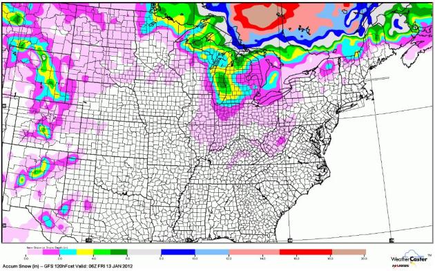
Expected Snow Through Thursday Night. The GFS model prints out a potentially plowable amount of snow across the Great Lakes, well over a foot for Ontario, Canada, but precious little snow over the Upper Midwest and New England.
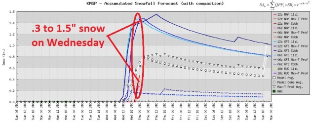
Nuisance Snow on Wednesday? The arrival of seasonably cold air sets off a period of light snow and flurries Wednesday. The cold front will move too quickly to tap moisture from the Gulf of Mexico, limiting amounts to anywhere from a coating to just over an inch.
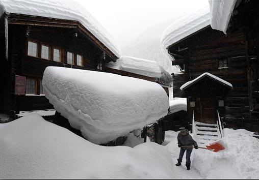
Smothered In Snow. Europe has been hammered by a parade of severe storms packing heavy snow, flooding rain, and winds gusting over hurricane force. According to the AP, over 3 feet of snow has fallen in the central Alps between eastern Switzerland and western Austria. Part of Austria's east-west railway link in Tyrol Province is closed. There's a considerable avalanche risk in the Swiss Alps and Jura Mountains. "A person shovels snow in front of snow-laden houses in Blatten, in the Loetschental Valley, Switzerland, Sunday, Jan. 8, 2012. AP Photo/dKeystone/Jean-Christophe Bott)."
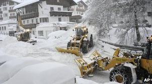
Austria Hit By Heavy Snow, Major Railway Line Shut. Up to 4 FEET of snow? Good grief. Nice to know some portion of the Northern Hemisphere is having a real winter. The BBC has the details: "Part of a major railway route has been shut down in the west of the country, and some villages and tourist resorts have been cut off. Up to 1.2 metres (4ft) of fresh snow has been recorded in some areas since Thursday. The authorities say the probability of avalanches is extremely high and widespread. The railway line that connects Oetzal, close to Innsbruck in Tyrol, and Bludenz in the far west of the country has been shut and is expected to remain closed until Sunday afternoon, says the BBC's Bethany Bell in Vienna."
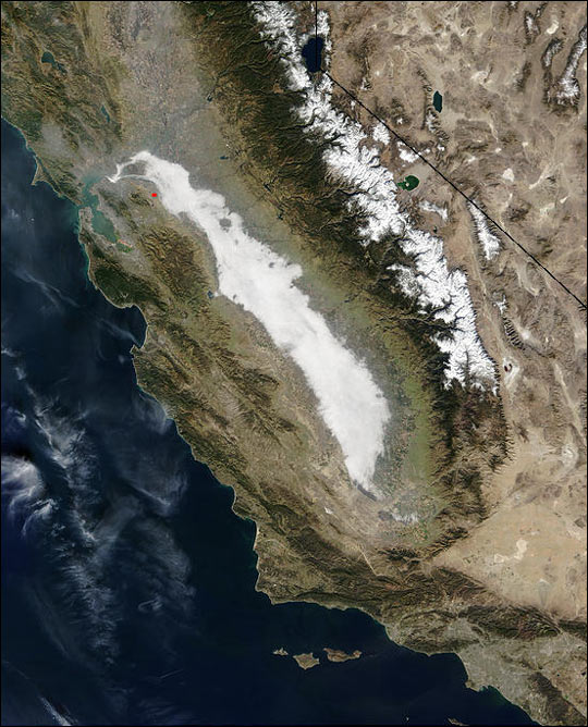
Record Pollution Hammers California's Ag Heartland. The story from msnbc.com: "This is the time of year when residents who often live with the nation's worst pollution often can draw a breath of fresh air. But this winter has not been kind to people who want to play outside in California's Central Valley. A dry December and January has stagnated air across California, but nowhere is the situation more serious than between Modesto and Bakersfield, where nearly every day dirty air has exceeded federal health standards. It's the worst air quality recorded in a dozen years, and it's the unhealthiest kind— microscopic, chemical-laden particles that can get into lungs and absorbed into the bloodstream to create health risks in everyone, not just the young and infirm." Photo above courtesy of NASA.

"The best advice is this: Don't take advice and don't give advice." - author unknown
"March-uary"
"It's too nice for there not to be consequences down the road" my wife whispered - gazing out at a kid (in shorts) - walking his dog. A friend in Burnsville sent me a photo of trees budding (on the blog); flowers are sprouting in New Hampshire and many lakes in Michigan have yet to freeze. It's a bit of a paradox: I don't miss the wind chill, but part of me worries about what our winter no-show means. Was last winter a fluke? Is this the "new normal"?
2010-2011 was probably the most severe year in America's history, going back to 1816. Weather Underground founder Jeff Masters points to "an extreme jet stream configuration"; persistent blocking patterns keeping our steering winds blowing from the Pacific. There seems to be more energy in the system. A symptom of climate change? Possibly, but melting arctic ice and solar activity may also play a role. The truth: we're in uncharted waters.
The record high today and Tuesday is 49. We'll come close, especially tomorrow, when 50s will be widespread south/west of the metro. A coating-1" Wednesday gives way to seasonable cold by late week; 30s and a few 40s possible the last week of January.
A "no subzero" January? Don't rule it out.
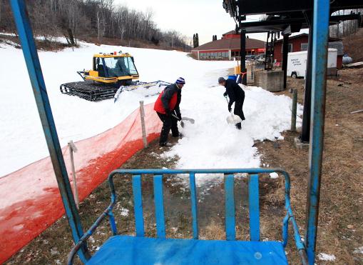
Photo credit above: "In this Jan. 3, 2012 photo, Andrew Arens and Scott Rodeghier shovel show to create a loading ramp for a chair lift at Coffee Mill Ski Area in Wabasha, Minn. The lack of snow this winter has delayed the opening of all the runs at the ski hill. (AP Photo/Winona Daily News, Andrew Link)."
Climate Stories...
Global Warming: European Species Lag In Species Shift. The story from AFP: "PARIS — Fast-track warming in Europe is making butterflies and birds fall behind in the move to cooler habitats and prompting a worrying turnover in alpine plant species, studies published Sunday said. The papers, both published by the journal Nature Climate Change, are the biggest endeavour yet to pinpoint impacts on European biodiversity from accelerating global temperatures. A team led by Vincent Devictor of France's National Centre for Scientific Research (CNRS) found that from 1990 to 2008, average temperatures in Europe rose by one degree Celsius (1.8 degrees Fahrenheit). This is extremely high, being around 25 percent greater than the global average for all of the last century." Photo courtesy of NASA.
Extreme Is The New Normal. The story from New Zealand's Dominion Post:
"As I watch from my summer subtropical perch in Brisbane, Queensland, the somewhat unprecedented rains that deluged parts of Australia during the summer of 2010/11 have been replaced by sizzling heat waves this summer. These raise some pertinent lessons on climate and risk management for New Zealand. Firstly, let's look at some figures and ask the question of what are the climate mechanisms behind the heat waves. Figures from Australia's Bureau of Meteorology figures show that the highest temperatures of 2011 occurred in the third Australian heat wave of the year. This affected the Pilbara region in the north west of Western Australia. Multiple sites broke the previous Western Australian December record of 48.8 degrees Celsius." Photo above courtesy of Reuters.

Time To Stop Being Cynical About Corporate Money In Politics And Start Being Angry. Here's a post from Bill McKibbon, reposted from Tom Dispatch and Climate Progress: "My resolution for 2012 is to be naïve — dangerously naïve. I’m aware that the usual recipe for political effectiveness is just the opposite: to be cynical, calculating, an insider. But if you think, as I do, that we need deep change in this country, then cynicism is a sucker’s bet. Try as hard as you can, you’re never going to be as cynical as the corporations and the harem of politicians they pay for. It’s like trying to outchant a Buddhist monastery. Here’s my case in point, one of a thousand stories people working for social change could tell: All last fall, most of the environmental movement, including 350.org, the group I helped found, waged a fight against the planned Keystone XL pipeline that would bring some of the dirtiest energy on the planet from Canada through the U.S. to the Gulf Coast. We waged our struggle against building it out in the open, presenting scientific argument, holding demonstrations, and attending hearings. We sent 1,253 people to jail in the largest civil disobedience action in a generation. Meanwhile, more than half a million Americans offered public comments against the pipeline, the most on any energy project in the nation’s history."