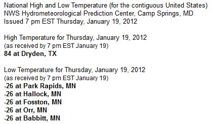
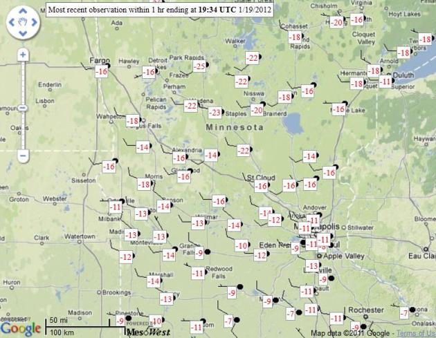
Coldest In The Lower 48. 5 different Minnesota towns came in at -26 Thursday morning, coldest in the lower 48 states.
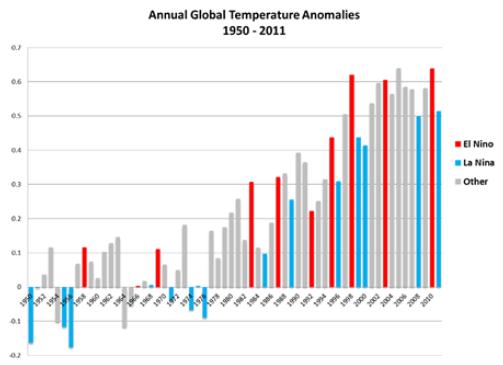
2011: 10th warmest year worldwide. Warmest La Nina year on record. Capital Weather Gang has details below.

"Men can bear all things except good days." - Dutch Proverb
-53 F. Grand Marais
-41 F. Brainerd
* photo above courtesy of the AP.
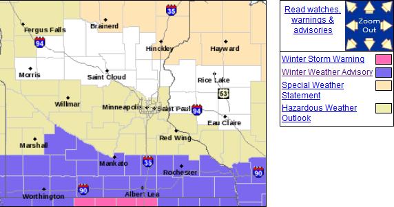
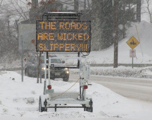
Tougher Travel South of MSP. The farther south you drive on I-35 the worse travel conditions will be today. The National Weather Service has posted Winter Weather Advisories for southern Minnesota, Winter Storm Warnings just south of the Iowa border.
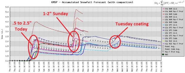
Snow Potential. Although no major storms are brewing (a west/northwest wind flow aloft will limit how much moisture can surge into Minnesota anytime soon) we could see 2" today, another inch or 2 Sunday, maybe a Tuesday coating. LIke forecasting weather in Wichita.
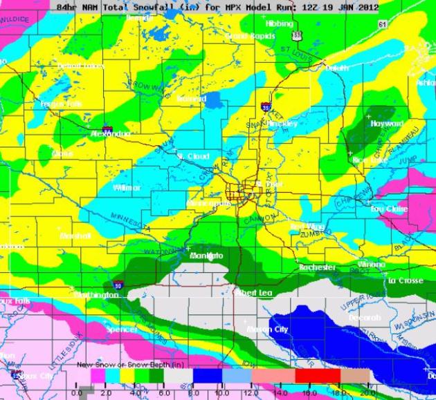
Plowable Far Southern Minnesota. The latest NAM model prints out some 3-6" amounts over far southern Minnesota, south of Mankato, from Albert Lea to La Crosse. Some 8" amounts are predicted for northeastern Iowa and southern Wisconsin - metro Chicago may pick up 3-6". O 'Hare and Midway will be a mess later today.
Photo credit above: "In this Monday, Jan. 16, 2012 photo, a family skates across Mendenhall Lake in Juneau, Alaska. Temperatures are forecast in the single digits all week. (AP Photo/The Juneau Empire, Michael Penn)."
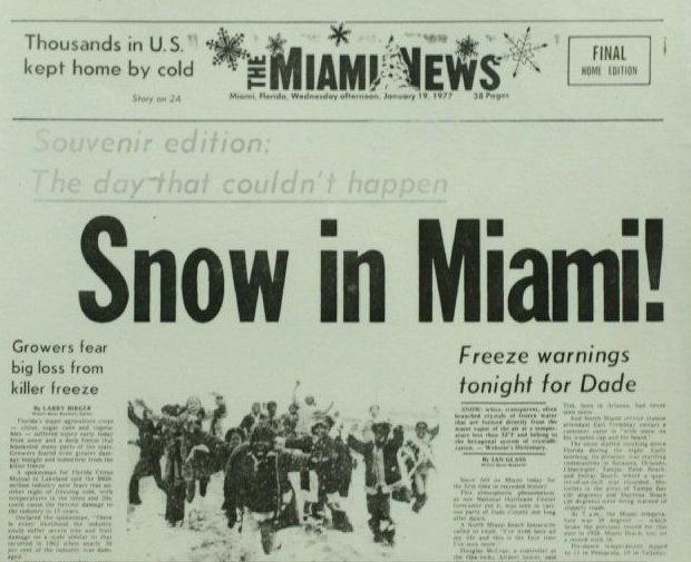
RECORD EVENT REPORT
NATIONAL WEATHER SERVICE CHANHASSEN MN
100 AM CST THU JAN 19 2012

...THE RECORD LATEST BELOW ZERO READING TIED IN MINNEAPOLIS/ST PAUL...

AT ONE MINUTE BEFORE MIDNIGHT...THE TEMPERATURE DROPPED BELOW ZERO AT
THE TWIN CITIES MINNEAPOLIS/ST PAUL AIRPORT.

THIS IS THE FIRST RECORDED BELOW ZERO READING THIS WINTER IN THE TWIN
CITIES.

THERE HAS NEVER BEEN A WINTER WITHOUT A BELOW ZERO TEMPERATURE READING
IN THE TWIN CITIES.

THIS TIES THE RECORD LATEST BELOW ZERO READING...
FIRST SET ON JANUARY 18 1889...AND TIED JANUARY 18 2002.
PUBLIC INFORMATION STATEMENT
NATIONAL WEATHER SERVICE FAIRBANKS AK
343 AM AKST WED JAN 18 2012

...THE 40 BELOW TEMPERATURES KEEP ON COMING AT FAIRBANKS...

THE LOW TEMPERATURE SO FAR TODAY AT THE FAIRBANKS INTERNATIONAL
AIRPORT HAS BEEN 43 BELOW. THIS IS THE 12TH DAY THIS MONTH WITH A
LOW TEMPERATURE OF 40 BELOW OR LOWER AT THE FAIRBANKS INTERNATIONAL
AIRPORT. THIS IS NOW THE GREATEST NUMBER OF 40 BELOW DAYS DURING
THE MONTH OF JANUARY SINCE THE 1989 COLD SNAP WHEN THERE WERE 14.
JANUARY 1971 STILL HOLDS THE RECORD FOR THE MOST 40 BELOW DAYS IN
JANUARY WITH 21.

TODAY IS THE 6TH DAY IN A ROW WITH A LOW TEMPERATURE OF 40 BELOW
OR COLDER. IT IS LONGEST CONSECUTIVE STRETCH OF 40 BELOW DAYS
SINCE THE COLD SNAP OF LATE DECEMBER 2008 INTO JANUARY 2009 THAT
PRODUCED 15 DAYS IN A ROW OF 40 BELOW COLD.
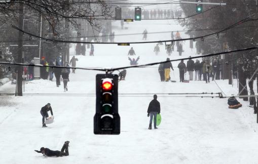
Don't Even Try To Plow This Road. This may be my favorite new photograph - a city street that was magically transformed into a sledding hill in Seattle. More details: "Sledders, skiers, snowboarders and pedestrians take over a snow-covered street in the Queen Anne neighborhood of Seattle Wednesday, Jan. 18, 2012. As snow started falling on Seattle Wednesday morning, the National Weather Service scaled back the amount expected in western Washington but said it would still be a significant event. The total in the city would likely be 3 to 6 inches, meteorologist Dustin Guy says. More is likely in southwest Washington, 4 to 8 inches, while less is expected in the northwest interior, 1 to 2 inches. (AP Photo/Elaine Thompson)."
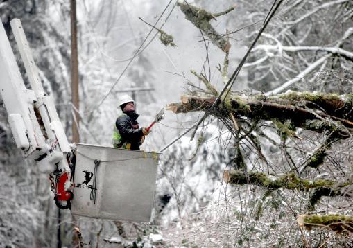
Photo credit above: "Travis Barrett leans back as a chunk of tree springs upward after his cut with an electric chainsaw, Thursday, Jan. 19, 2012 in Seattle. An ice storm followed heavy snow in western Washington, bringing down trees that killed one person and knocked out power for about 100,000 homes while sending cars and trucks spinning out of control. (AP Photo/The Seattle Times, Steve Ringman)."
...OREGON...
MT. HOOD MEADOWS 50.0 ESTIMATED 50-55
TIMBERLANE 45.0 ESTIMATED 45-55
BLAZED ALDER 35.0 ESTIMATED
MOUNT HOOD TEST 35.0 ESTIMATED 35-40
GOVERNMENT CAMP 34.0
BEAR GRASS 32.0 ESTIMATED 32-36
NORTH FORK 31.0
CLACKAMAS LAKE 30.0 ESTIMATED
CLEAR LAKE 30.0 ESTIMATED
DALY LAKE 30.0 ESTIMATED
GREENPOINT 30.0 ESTIMATED 30-35
LITTLE MEADOWS 30.0 ESTIMATED 30-35
MUD RIDGE 30.0 ESTIMATED 30-35
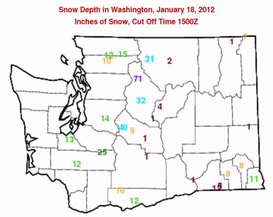
...WASHINGTON...
JUNE LAKE 31.0
SURPRISE LAKE 30.0 ESTIMATED
LEAVENWORTH 12.4 N 26.5
PLAIN 0.8 NW 26.0
WINLOCK 0.5 W 25.4
CALAMITY 25.0 ESTIMATED
LONE PINE 25.0 ESTIMATED 25-30
OLYMPIA 6.5 SW 25.0
PEPPER CREEK 25.0 ESTIMATED
SPENCER MEADOW 25.0 ESTIMATED
SWIFT CREEK 25.0 ESTIMATED 25-30
MINERAL 0.2 S 22.7 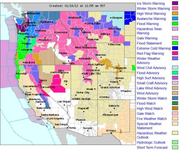
The Wild, Wild West. Check out all the National Weather Service watches, warnings and advisories over the western third of America; the weather stuck in a pattern that favors (major) storms sweeping inland from the Pacific Ocean.
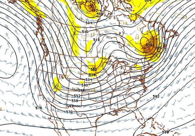
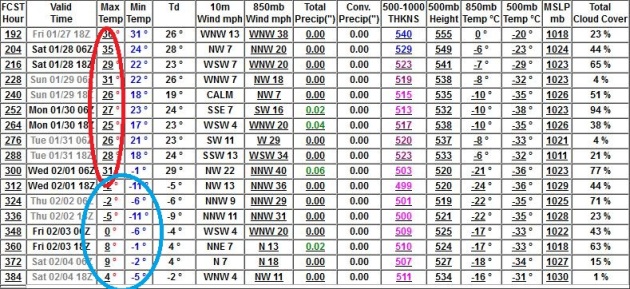
F-F-F February. After a relatively mild last week of January (highs consistently in the 30s) the GFS pulls much colder air into town the first few days of February, maybe a couple of days of single digit highs and 2-4 nights below zero. No, it's way too early to write off the Winter of 2012.
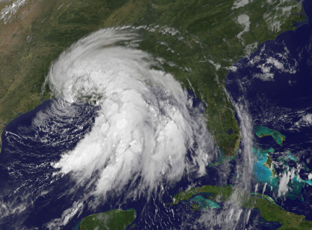
Two More Billion Dollar Disasters. NOAA is now reporting a total of 14 separate billion dollar weather disasters last year, shattering the old record of 9 set in 2008. The New York Times reports: "The count of billion-dollar weather disasters for 2011 has taken another jump. The National Oceanic and Atmospheric Administration, still adding up the costs of the extreme weather events that plagued the country last year, announced on Thursday that two more had surpassed the $1 billion mark, for a total of 14. And the agency is still counting. The latest additions were Tropical Storm Lee, in early September, and a severe weather outbreak in the Rockies and Midwest from July 10 to 14. Lee hit the Gulf Coast and caused wind and flood damage across a broad swath of the country, with some of the worst flooding in New York and Pennsylvania. The Rockies outbreak featured wind, hail and floods, notably in Colorado and Wyoming." Image of Tropical Storm Lee above courtesy of NASA.
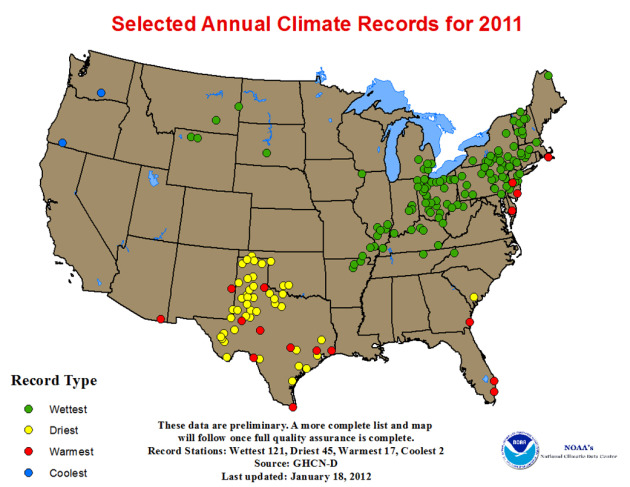
* NOAA has a great summary (pdf) of 2011's extremes here.
* A NOAA pdf of all the cities that set new records for wettest/driest years on record is here.
NASA images courtesy Jeff Schmaltz, LANCE/EOSDIS MODIS Rapid Response Team at NASA GSFC.
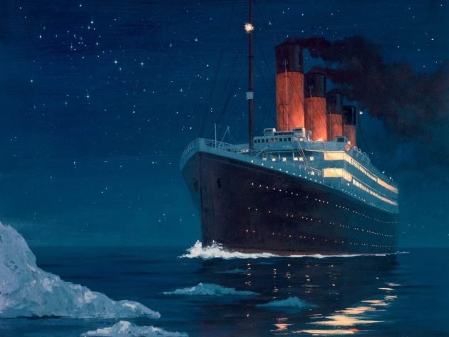
You Just Can't Make This Stuff Up. A Swiss passenger on the Costa Concordia, who was eating dinner in the ship's restaurant, reports that at the exact momen when the cruise ship hit the rocks, the piped-in music playing onboard was Celine Dion, singing "My Heart Will Go On", the title song from the movie Titanic. Source: German Tagesschau.


"In order to keep a true perspective of one's importance, everyone should have a dog that will worship him and a cat that will ignore him." - Dereke Bruce.
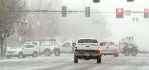
Black Ice Alert
Not all snow events are created equal. We all tend to (rightfully) fixate on "how many inches?" - when the more relevant question should be "how cold will it be as the snow falls?" Who care? MnDOT chemicals work best when the air temperature is in the 20s; major freeways tend to stay wet. But when it's this cold (single digits) traffic can compress snow into a thin film of glaze ice, the "black ice" that can leave humbled SUV drivers in the nearest ditch. Be careful out there today; leave extra time for your commute. Snowfall amounts will range from 1-3 inches (heaviest amounts south metro).
Expect one more night near zero, followed by a fairly quick warming trend - 20s on Sunday will feel like a Club Med Vacation!
A Pacific flow returns for much of next week, meaning highs near 30 by late week. 40 isn't out of the question the last weekend of January. In spite of The Boat Show underway in Minneapolis, spring is NOT right around the corner. A mild end to January gives way to yet another arctic swipe the first week of February.
Storms? A little slush is possible Sunday (more for north/west Minnesota), but snow will fall in dribs and drabs the next 2 weeks. Status quo right?

"Politicians and diapers should be changed frequently and all for the same rason." - Jose Maria de Exa de Queiroz
Climate Stories....
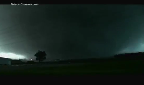
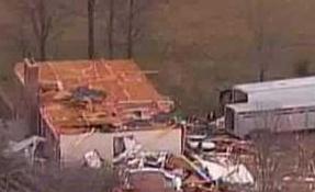
Did Global Warming Destroy My Hometown? A uniquely personal story from Popular Science: "The tornado that destroyed my hometown was born in an otherwise unremarkable atmospheric collision over the American Central Plains. On May 22, 2011, a geostationary satellite 22,300 miles overhead recorded a large collection of cloud lines drifting over southeastern Kansas. At around 2 p.m, one of the cloud lines exploded, like a cartographic-scale dry-ice bomb. Dense white vapors poured from nothing, and over the next five hours the National Oceanic and Atmospheric Administration monitored the growing supercell thunderstorm as it drifted toward a three-letter abbreviation on the map: “JLN.” Just after 5 p.m., two storm chasers driving toward the western edge of Joplin, Missouri, spotted a translucent set of tendrils reaching down from the storm’s low black thunderhead. Almost as quickly as they formed, the tendrils disappeared. And then things took a turn. A dark blob half a mile wide congealed and dropped from the clouds. As it touched the ground, it filled with sparks from ruptured power lines, like a jar of fireflies. At 5:41, the National Weather Service office in Springfield, Missouri, issued this alert: NUMEROUS REPORTS OF TORNADO ON THE GROUND WEST OF JOPLIN AND POWER FLASHES."
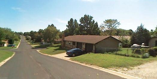
Photo credit above left: "Pre-Tornado The Joplin, Missouri neighborhood where the author grew up. Google Maps."
Photo of Joplin tornado upper right courtesy of twisterchasers.com and NOAA.