10 minutes of additional daylight since the Winter Solstice, on December 21.
10 years. In only 10 of the last 120 years of weather records has Minnesota reported a 60-degree high anywhere in the state.
1. This is the first time in recorded history where a 60-degree high has been recorded anywhere in Minnesota during the first week of January. Source: MN State Climate Office.
Year Without A (real) Winter? It's probably wildly premature to even utter those words in private, much less public, but long-range guidance shows little or no chance of sustained, prolonged, arctic air through the 4th week of January. I know - I don't quite believe it either. Details below.

"For the first time in 30 years, a lack of snow has not allowed us to open the back bowls in Vail as of January 6, 2012, and, for the first time since the late 1800s it did not snow at all in Tahoe in December.” - from a Bloomberg article on the dire lack of snow impacting ski resorts nationwide. Photo above courtesy of bigskyresort.com.
"There has never been a 60-degree temperature recorded during the first week of January in Minnesota's modern climate record. The warmest temperature ever recorded in Minnesota during the first week of January is 59 degrees, occurring on January 7, 2003 in Amboy, MN. The warmest temperature ever recorded in MInnesota on January 5 is 57 degrees, recorded at Crookston in 1902. Reaching 60 degrees ANY time ANYWHERE in January is quite rare, occurring only 10 years of the 120 year modern record. The all-time record high temperature for any day in January is 69 degrees, occurring January 24, 1981 in Montevideo." - MN State Climate Office, as reported by the local NWS office.

2001-2002: winter with the fewest nights at or below zero (2). Average for the winter is closer to 30 subzero nights.
"The mildest winter we have had in the last 120 years occurred ten years ago, with only two zero or subzero days. December 2001 had no subzero days, there was only one January 2002 (-2) occuring on Jan. 18, 2002, which was latest subzero day in history, and one in March (-3) on the third. There were no subzero days in February, 2002. The coldest day of the winter, at -3, was the highest min for any winter in history."
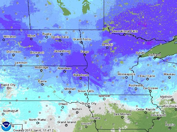
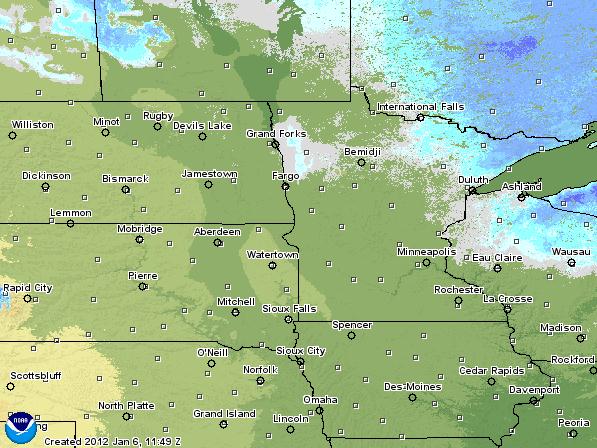
January 6. 2011 vs. 2012. The map on the left shows snowcover a year ago; 10-15" on the ground in the metro with 20-30" snow reported over much of northern, central and western Minnesota. Compare that with the most recent snowcover map (right), showing a few inches over the MN Arrowhead. Data courtesy of NOAA.
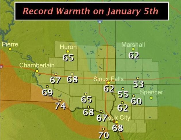
74 F. at Philip, South Dakota. That breaks the old record of 46 in 2002.
63 F. at Aberdeen, South Dakota, shattering the old record of 46 in 1935. It's also the warmest temperature ever observed in Aberdeen during the month of January since weather records were started in the late 1800s.
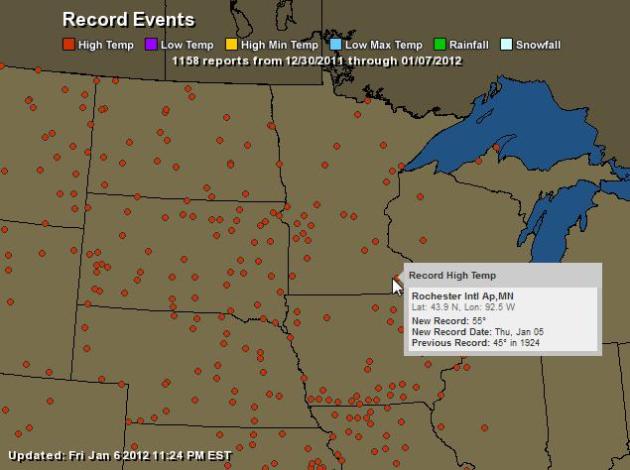
One Amazing Map. 1158 records in one week? Most of these were record highs. Click on the Ham Weather interactive map showing all the details. I honestly can't remember seeing such widespread record highs in January in the 35 years I've been doing this. When meteorologists call this "historic January weather" they aren't exaggerating.
South Dakota
Philip 74
East Rapid City 71
Mitchell 68 (*also the all-time warmest high in January)
Yankton 68
Pierre 66
Huron 65 (*also the all-time warmest high in January)
Aberdeen 63 *(also the all-time warmest high in January)
Hot Springs 62
Pine Ridge 62
Sioux Falls 62
Camp Crook 61
Buffalo 59
Sisseton 59
Bison 58
Watertown 57
Mobridge 55
North Dakota
Dickinson 62
Minot 61 * (also the all-time warmest high in January)
Bismarck 59
Williston 58 *(also the all-time warmest high in January)
Jamestown 56 *(ties the all-time warmest high in January set in 1908)
Fargo 55 *(also the all-time warmest high in January)
Grand Forks 47
* Thanks to Julie Gaddy from Earth Networks for helping me summarize Thursday's record highs.
Thursday Records. More details from the Chanhassen office of the NWS here.
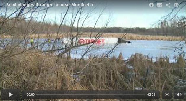
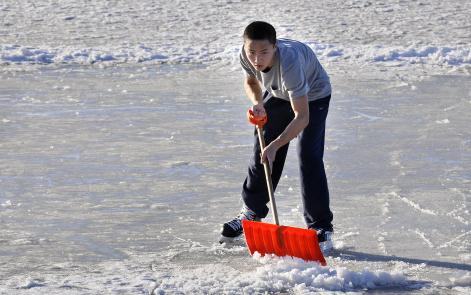
Semi Plunges Through Ice Near Monticello. There was (reportedly) about 4-6" of ice, fairly unstable ice, on the lake - strong enough to support a snowmobile, but no match for a semi. KARE-11 has the details: "MONTICELLO, Minn. - Eight hours after plunging through the ice covering a pond just off I-94 near Monticello, a semi-trailer truck is finally back on solid ground. Just before 6:30 a.m. Friday, 35-year-old John Nettifee of Anoka was pulling a Target trailer on eastbound I-94 when he lost control, left the road, crossed over lanes of oncoming westbound traffic and skidded onto the pond. The semi skidded 100 to 200 yards across the ice before breaking through."
Serious Time Warp. Thanks to the Facebook page of the Sioux Falls, South Dakota National Weather Service for posting this.
820: "The number of disasters around the world, exceeding the 630 average over 30 years. They caused $105 billion in insured losses, more than any other year because of the higher frequency and more insured property in risk-prone areas." - from an article on 2011 weather disasters in the Sun Sentinel newspaper below.
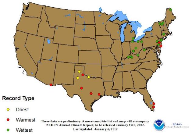
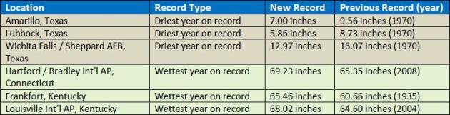
2011 Extremes. Too wet, too dry, too warm, too windy, too wild. 2011 was an historic year around the USA, as reported by the NCDC, the National Climatic Data Center: "The following are annual records broken or tied at selected stations for the year 2011, compiled from National Weather Service “Record Event Reports”. This list should be considered preliminary and incomplete; it covers only larger towns and cities, and final quality assurance has not been performed on the 2011 data. When the data are complete, the final number of stations with new annual records will likely be larger. A more complete list will accompany NCDC’s annual climate report, to be released January 19th, 2012."
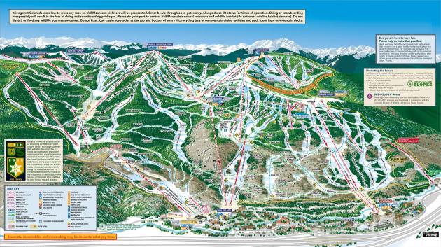
Vail Resorts Struggle As Snowless Season Hits. The story from Bloomberg: "Vail Resorts Inc. (MTN) shares have fallen 15 percent since Dec. 23 as major ski trails were closed at the company’s mountain properties in the western U.S. because of a lack of snow. Visitors to the company’s resorts were down 15.3 percent compared to this time last year, Rob Katz, chief executive of the Broomfield, Colorado-based company, said in a statement. Lift ticket revenue was up 0.6 percent and revenue from ski school was up 0.9 percent, even though “very unusual” weather had reduced skier visits and the use of season passes, he said. “For the first time in 30 years, a lack of snow has not allowed us to open the back bowls in Vail as of January 6, 2012, and, for the first time since the late 1800s it did not snow at all in Tahoe in December,” Katz said in the statement."
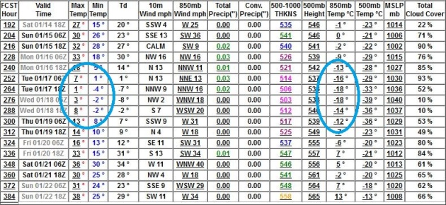
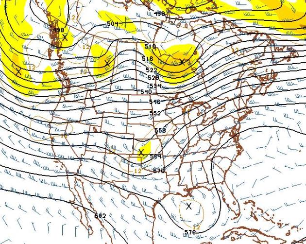
Still Waiting. Here is the predicted 500mb map for January 23 (GFS), showing a continued upper level wind flow from the west, from the Pacific. In spite of a brief cold snap around January 17-18 I still don't see any significant risk of sustained, bitter cold through the 4th week of January. I'd say "amazing" again, but I'm getting way too repetitive. Let's settle for extraordinary. At this rate this may be as close as any of us will come to a Year Without A Winter.

$35.9 billion: The insured losses in 2011, which exceeds the $23.8 billion average for 2000 to 2010. That includes paid and projected losses.
552: The number of lives lost in tornado outbreaks in the Midwest and South, making it the deadliest year for U.S. tornadoes. There were 748 tornadoes observed in April.
8.3 million: The acres burned from wildfires in Texas.
$7 billion: Insured losses from Hurricane Irene, including about $2.7 billion covered by the federal government's flood insurance program.
820: The number of disasters around the world, exceeding the 630 average over 30 years. They caused $105 billion in insured losses, more than any other year because of the higher frequency and more insured property in risk-prone areas."
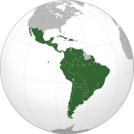
Wild Weather Hits Latin America. The story from AP: "CHIA, Colombia (AP) — From Chile to Colombia to Mexico, Latin America has been battered recently by wildfires, floods and droughts. For many witnessing the extreme weather in the region and around the world, the question that comes up again and again is whether climate change is playing a role. The response from experts: Probably. While leading climate scientists are unable to pin any single flood or heat wave solely on climate change, experts say the number of extreme weather events is increasing worldwide and the evidence suggests global warming is having an impact."
Debris From Japan Tsunami Washes Onto Cannon Beach, Yakutat, Alaska. From the National Weather Service in Alaska: "Debris from the Japanese Tsunami has washed up on Cannon Beach in Yakutat. These floats are believed to have come for an oyster farming operation. Photo by Jack Endicott."
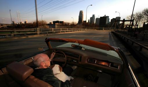
January Convertibles
At 2:30 pm on Thursday the mercury at Minneota (Lyon County) hit 64 degrees. According to Dr. Mark Seeley January 5 was the warmest in our state's history; a touch of late April in January.
We have yet to hit zero in the metro area. According to consulting meteorologist Dean DeHarpporte, we may come close to setting a record for the latest subzero reading in the metro (Jan. 18, 2002). That winter we only had 2 nights at, or below, zero. In 1996 and 2006 MSP had NO subzero nights during January.
We're due for a little payback, and by late next week it will feel like winter again; the first subzero nights of winter possible January 18-20. Fresh outbreaks of numbing air often spin up significant snow, but I still don't see a respectable "storm" looking out 2 weeks. A quiet weekend gives way to another shot at 40 Monday and Tuesday - a lousy coating of snow Wednesday marking the arrival of seasonably cold air.
Food for thought: based on the latest 30 year averages for MSP, the coldest day of the year (on average) is 5 days away, on January 12. And since December 21 we've picked up 10 minutes of additional daylight.
It's too early to babble about spring fever right? Sorry.
Climate Stories....
Hanson Et Al: "Extreme Heat Waves....In Texas and Oklahoma In 2011, and Moscow In 2010, Were "Caused" By Global Warming. Joe Romm at Climate Progress has the details: “Climate dice,” describing the chance of unusually warm or cool seasons relative to climatology, have become progressively “loaded” in the past 30 years, coincident with rapid global warming. The distribution of seasonal mean temperature anomalies has shifted toward higher temperatures and the range of anomalies has increased. An important change is the emergence of a category of summertime extremely hot outliers, more than three standard deviations (σ) warmer than climatology. This hot extreme, which covered much less than 1% of Earth’s surface in the period of climatology [1951-1980], now typically covers about 10% of the land area. We conclude that extreme heat waves, such as that in Texas and Oklahoma in 2011 and Moscow in 2010, were “caused” by global warming, because their likelihood was negligible prior to the recent rapid global warming. We discuss practical implications of this substantial, growing climate change."
Scientists Back "Significant Broadening" Of Climate Research Amid Tight Budgets. The story from CNN: "U.S. scientists want to expand research into climate change to focus on its social effects and ways to adapt to a changing planet, but tighter budgets may crimp those plans, the National Academy of Sciences reported Thursday. The 10-year plan reviewed by the academy represents a "significant broadening" of the federal Global Change Research Program, which includes researchers from across the U.S. government. Thursday's report by the academy's National Research Council generally supports the proposal but warned that researchers may have to overcome fiscal as well as scientific hurdles. "The proposed broadening of the program's scope from climate change only to climate change and 'climate-related global changes' is an important step in the right direction," the review committee concluded. But it cautioned that "in an era of increasingly constrained budget resources, those questions of how will become paramount."

Climate Scientist Spurned By Gingrich Laments "Politicization". The Hill has more details: "A week after GOP White House hopeful Newt Gingrich said he nixed plans for a chapter on climate change in his new book, the author of the chapter is lamenting the “politicization and polarization” of the issue. “I really, really deplore the politicization and polarization of this issue,” Katharine Hayhoe, a well-known climate scientist who had been tasked with writing a chapter on climate change for Gingrich’s new book on the environment, told The Guardian, a British newspaper. “There are these increasingly unprincipled attempts to polarize the science when the science is fact — like the sky is blue, the grass is green and the temperature of our planet is increasing.” Photo credit above: treehugger.com.